

Texas map
Randall County map
About 150,547 people live here (Census Bureau, 2024 estimate). The sheet's index lists 300 streets; Pullman Road, Tradewind Street and South Eastern Street cross the most grid squares. Things to do inside the boundary: Bill's Backyard Classics, Palo Duro Canyon State Park and Panhandle–Plains Historical Museum.
Open the map (PDF, US Letter)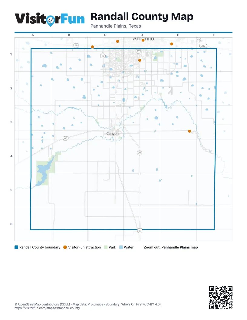
Street index of Randall County
Each street on the sheet and the grid squares it crosses.
- Marshall Formby Memorial HighwayC3, D3, D4, D5, D6
- Canyon ExpresswayC1, D1, C2, C3
- South US Highway 87C4, C5, D5, D6
- South Soncy RoadC1, C2, C3, C4
- West Hollywood RoadB2, C2, D2
- Helium RoadC1, C2, C3, C6
- Claude HighwayD2, E2, F2
- FM 1541D2, D3, D4
- West State Highway 217D3, E3
- Park Road 5E3, F3, F4
- North 23rd StreetC3
- East Hollywood RoadD2, E2
- Hereford HighwayC3
- South Lakeside DriveE1, E2, E3
- 4th AvenueC3, D3
- East Loop 335 SouthE1, E2
- 23rd StreetC3, C4
- West Loop 335 SouthC1, C2
- East State Highway 217D3
- Soncy RoadC1, C3, C4
- 11th StreetC3
- North 11th StreetC3
- North Tallmage AvenueD6
- Canyon DriveC1, D1, C2, C3, E4
- County Line RoadB6, C6, D6, E6, F6
- Pullman RoadE1, E2, F2, F3, E5, E6
- Tradewind StreetD1, D2, D3, D4, D5, D6
- South Eastern StreetE1, E2, E3, E4, E5, E6
- South Georgia StreetD1, D2, D3, D5, D6
- Buffalo Lake RoadA4, B4, C4
- Sampson RoadB1, B2, B3, B4
- Wayside RoadD5, E5, F5, E6, F6
- West County Road 34A1, B1, C1
- West Dowlin RoadC5, D5, E5
- Lair RoadB2, C2
- Bushland RoadB1, B2, B3, B5
- South Western StreetD1, D2, D3
- Bell StreetC1, C2, C3, C6
- South Osage StreetD1, D2, D3, D4
- West Farmers AvenueA1, B1, C1, D1
- Dowell RoadC2, C3, C4, C6
- South Coulter StreetC1, C2
- Brown RoadC3, C4, C5
- East Farmers AvenueD1, E1, F1
- West Sundown LaneB2, C2, D2
- Southwest 45th AvenueC1, D1
- South Grand StreetD1, D2
- Southwest 34th AvenueC1, D1
- West Rockwell RoadC3, D3
- Southeast 34th AvenueD1, E1
- FM 1705C4, C5
- Southeast 58th AvenueD1, E1
- West McCormick RoadC2, D2
- South Washington StreetD1, D2
- Arden RoadC1, D1
- Hillside RoadC1, D1
- North 3rd AvenueC3
- West Dowlen RoadB5, C5, E5
- Southeast 46th AvenueD1
- Parker StreetD1
- Southwest 58th AvenueD1
- West McAfee RoadD2
- South Travis StreetD1
- Mack RoadC2, D2
- Farmers AvenueD1
- Paramount BoulevardD1
- Teckla BoulevardD1
- Fulton DriveC1, D1
- Rockwell RoadD3
- South Tyler StreetD1
- Sleepy Hollow BoulevardC1
- Southwest 46th AvenueD1
- Tanglewood RoadD2
- 10th AvenueC3
- Mc Cormick RoadB2, C2
- South Harrison StreetD1
- Southwest 81st AvenueC2
- Claude RoadD2
- 28th StreetC3
- Van Winkle DriveC1
- McCarty BoulevardD1
- Mockingbird LaneD1
- Star LaneC1, D1
- West 34th AvenueC1
- Southwest 36th AvenueC1, D1
- Hawthorne DriveD1
- Susan DriveD1
- Darrell AvenueD1
- James Louis DriveD1
- South Taylor StreetD1
- East Northern StreetD6
- Southeast 31st AvenueD1, E1
- Hillcrest DriveC3
- West 4th AvenueC3
- Wimberly RoadD1
- West 32nd AvenueD1
- South Arthur StreetD1
- FM 285F5
- Century DriveD1
- Hardin DriveD1
- Criss StreetD1
- Moss LaneD1
- Emory DriveD1
- Southwest 36th Avenue/Canyon DriveD1
- Surf DriveD1
- Southeast 46th StreetD1
- I-27 Frontage RoadC3, D3, D4, D5, D6
- South Blessen RoadB1, B2, B4, B5, B6
- Arnot RoadB1, B2, B3, B4, B5
- Hope RoadC1, C2, C3, C4, C5, C6
- West Hungate RoadB5, C5, D5
- Adkisson RoadA1, A2, A3, A4
- West Country Club RoadA3, B3, C3
- Juett Atterbury RoadE1, E2, E5, E6
- West Cemetery RoadC4, D4
- Coulter RoadC4, C5
- Hunsley RoadA3, C3, D3
- West County Road 46A1, B1
- East County Road 58E1, F1
- South Whitaker RoadE1, E2
- East County Road 34E1, F1
- South Masterson RoadF1
- Holley RoadD6
- Park Road 5 AlternateF4
- FM 1721E5
- East Sundown LaneD2
- Bowie StreetD1
- Country Club DriveC3
- 8th AvenueC3
- New England ParkwayC1
- South Bonham StreetD1
- 6th AvenueC3
- West Costley RoadC2
- Heritage Hills ParkwayC2
- South Lipscomb StreetD1
- White Fence RoadC3, D3
- Andover DriveC1
- South Virginia StreetD1
- Southwest 37th AvenueC1, D1
- Tripp AvenueC1
- Bayswater RoadC1
- South Milam StreetD1
- South Polk StreetD1
- South Austin StreetD1
- South Van Buren StreetD1
- Town Square BoulevardC1
- Kingston RoadC1, D1
- Beacon RoadD2
- Aberdeen ParkwayC1
- Harmony StreetC1, D1
- West 42nd AvenueC1, D1
- Catalpa LaneD1
- 1st AvenueC3
- Southeast 32nd AvenueD1, E1
- Fleetwood DriveD1
- Overlook DriveD1, C3
- Southwest 35th AvenueC1, D1
- Shawnee TrailD1
- Southwest 48th AvenueC1, D1
- Cornell StreetC1, D1
- South Timbercreek DriveD2
- Southwest 47th AvenueC1, D1
- John Thomas StreetC1, C2
- Russell Long BoulevardC3
- Mesa CircleD1
- Burlington RoadD2
- Tanglewood DriveD2, E2
- Ross StreetD1
- Greg StreetC3
- Southridge DriveD2, C3
- Pilgrim DriveC1
- Nancy Ellen StreetC1
- Dreyfuss RoadC1
- 26th StreetC3
- Elmhurst RoadC1
- Sheldon RoadC1, C2
- Hancock StreetC1
- South Rusk StreetD1
- Southwest 77th AvenueC1
- Scotty DriveC2, D2
- Robin RoadC3
- Longhorn TrailD1
- Hunsley Hills BoulevardC3
- Danbury StreetC1
- Vail DriveD1, D2
- Alexandria DriveD1, D2
- Wesley DriveC1
- Lamount DriveD1, D2
- Nicholas DriveC1
- Perry AvenueC1
- Knoll DriveD2
- Upton RoadC2
- Continental ParkwayC1
- Andrews AvenueC1, D1
- South Seminole StreetD1
- Glenoak LaneC1
- Hampton DriveC1
- Mays AvenueD1
- Santa Fe TrailD2, C3
- Willow StreetD1
- Grimes CircleC2, C3
- Capt Woodrow Call TrailE1, E2
- Southwest 53rd AvenueC1, D1
- Terrace DriveD1
- Calumet RoadC1
- Stardust LaneD1
- Hurst RoadC1
- Julie DriveD1
- South Lamar StreetD1
- Langtry DriveC1
- South Bolton StreetE1
- Pineridge DriveC1
- Mosley StreetC1
- City View DriveD1, D2
- Douglas DriveD1
- Capulin LaneD1
- Trammel AvenueD2
- Sandie DriveC1
- Georgetown DriveC1
- Southeast 114th AvenueD2
- Baughman DriveC1
- Janet DriveD1, D2
- Pinnacle DriveC2
- Dobie StreetD2
- Camp LaneC1, D1
- Oakhurst DriveC1
- 15th StreetC3
- Scotswood DriveD2
- Canode DriveC1
- Atkinsen StreetC1
- Potts DriveC2
- Southwest 32nd AvenueD1
- Wild Plum DriveD2
- Ridgecrest CircleD1
- Rutson DriveC1
- Granada DriveC1, D1
- Cruse LaneC2, D2
- North Timbercreek DriveD2
- Green Haven RoadD1
- Barstow DriveD2
- Estacado LaneC1
- Oxford DriveC2
- McAfee LaneD2
- Kingsgate DriveC1
- Wilbur DriveD1
- Time Square BoulevardC1
- South Mirror StreetD1
- Leigh AvenueD1
- Bent Tree DriveC1
- Hornady StreetD1
- West Valencia DriveD2
- Hatton RoadD1
- 4th StreetC3
- East Tangier AvenueD2
- Patriot DriveC1
- Hyde ParkwayC1
- Angel LaneD2, D3
- Thunder RoadC2
- Huntington DriveC1
- Greenways DriveC1
- Buffalo Stadium RoadC3
- Capt Augustus McCrea TrailE1
- Air Park DriveD1
- Athens StreetD1
- Meadowgreen DriveC1, D1, C2
- Southeast 40th AvenueD1
- Rutgers StreetC1, D1
- Farwell DriveC1
- Danvers DriveC1
- Foxcroft DriveC1
- West 6th AvenueC3
- Van Tassel StreetC1
- Cherokee TrailD1
- Saxon WayC1
- Reeder DriveC1
- Tarter AvenueC1
- Lufrank StreetD2
- Southeast 44th AvenueD1
- Glenwood DriveC1
- Hawk LaneD1
- College AvenueC1, D1
- Southwest 54th AvenueC1
- Bush DriveC1
- Wesley RoadC1
- Hansford DriveC1
- Main StreetC3
- Avent StreetC2, C3
- Addison DriveC2
- Tampa Bay AvenueD2
- Wentworth DriveC1
- Duncan DriveD1
- Roach DriveC1
- Garden Way DriveC2
- Wineinger RoadD1
- Blake AvenueC1
- West 37th AvenueC1
- Holyoke TrailC1
- Taylor LaneC3
- South Nelson StreetD1
- Randolph RoadC1, D1
Things to do on the Randall County map
Places on the map
- Ascension Academy
- Bivins Lake
- Blue Sky Airfield
- Buffalo AIrport
- Buffalo Lake
- Buffalo Lake National Wildlife Refuge
- Busan Way Playa Lake
- Camp Don Harrington
- Canyon
- Canyon Country Club
- Canyon Trails at Buffalo Hill
- Comanche Trail Golf Course
- Currie Lake
- Diamond Horseshoe Playa
- Frog Lake
- Greenways Park
- High Plains Retreat Center
- John Stiff Memorial Park
- Lake Tanglewood
- Lake Tanglewood Golf Course
- Llano Cemetery
- Maxwell's Pumpkin Farm
- McCarty Lake
- McDonald Lake
- Mesquite Campground
- Palisades
- Palo Duro Club Lake
- Palo Duro Creek Golf Course
- Playa Lake 7
- Randall County Jail
- Republic Services Landfill
- Rick Klein Park BMX Course
- Rockwell Place
- Southeast Complex
- Tarantula
- Timbercreek Canyon
- Town Square Village
- Tradewind Airport
- Umbarger
- Western Business Park
Next to Randall County
© OpenStreetMap contributors, Open Database License, openstreetmap.org/copyright · Map data: Protomaps · Boundary: Who's On First (CC-BY 4.0); Quattroshapes (CC BY 2.0)