

Texas map
Royse City map
About 26,387 people live here (Census Bureau, 2024 estimate). The sheet's index lists 300 streets; Congressman Ralph Hall Highway, East Interstate 30 and West Main Street cross the most grid squares. Also on it: Stone River Golf Club, Royse City High School and Anita Scott Elementary School.
Open the map (PDF, US Letter)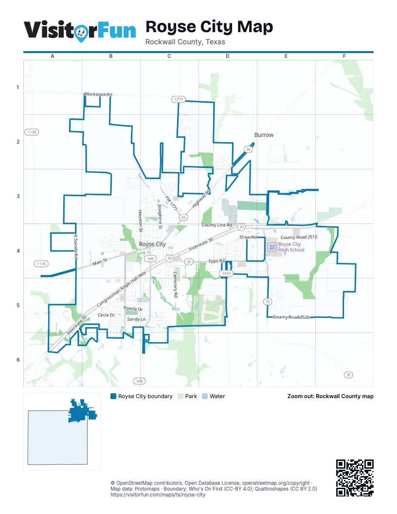
Street index of Royse City
Each street on the sheet and the grid squares it crosses.
- Congressman Ralph Hall HighwayB4, C4, D4, A5, B5, A6
- West Main StreetA4, B4, C4
- Highway 66C3, D3, C4
- East State Highway 66C4
- East Main StreetC4
- East Interstate 30C4, D4, E4, A5, B5, A6
- West Interstate 30B4, C4, B5
- South Farm to Market 548C4, C5, C6
- Epps RoadC4, D4
- Farm-to-Market Road 35D4, E4, E5
- FM 1777C3
- FM 2642E4
- South Elm StreetC4
- South FM 548C4
- South Erby Campbell BoulevardB4, B5, B6
- I-30 Frontage RoadE4, F4
- Farm to Market 2453D4, D5
- Blackstock RoadB1
- North Elm StreetC4
- C.D. Boren ParkwayA5
- County Road 588B3, C3
- East County Line RoadC4, D4
- County Road 2515E4, F4
- Hidden Creek DriveB3, C3
- North Houston StreetB3, C3, C4
- Cemetery RoadC4, C5
- County Road 2596F4, F5
- County Road 677C1, D1
- North Josephine StreetC3, C4
- North Sorrels RoadA4
- County Road 2595F5
- County Road 2526E5
- Circle DriveB5
- Live Oak StreetC3, C4
- Rowdy DriveB5, C5
- Spruce StreetD4, E4
- West County Line RoadA4, B4, C4
- Shaw RoadD4, E4
- Liberty Crossing AvenueC4, C5
- Anglers WayD4
- Stone River BoulevardD5
- Rustic Meadow DriveB4
- Wind Knot WayD4
- Clearwater WayD4
- East Old Greenville RoadC4
- Perdenales DriveD5
- County Road 2594E5
- Industrial DriveD3, D4
- Candlebrook CircleB5
- Cookston LaneB5, C5
- South Bell StreetC4
- Kingdom AvenueC1, C2
- Sandy LaneB5, C5
- Elm Grove RoadB5, B6
- Welch DriveB5, C5
- East Lamar StreetC4
- Starlight LaneC5
- Verandah BoulevardE3
- Lakes DriveC5
- Oak Grove LaneB4
- Kansas StreetC5
- County Road 1031D3
- Ranch RoadD5
- Llano DriveD5
- Green Terrace DriveC3
- Fairway LaneD5
- Center StreetC3, C4
- Peterson StreetC3, C4
- Meadowlark LaneC3
- Lesli DriveB5
- Tamarack LaneE5
- Ame LaneB5, C5
- Brookhaven DriveB4
- County Road 940C3
- Prospector LaneD2
- Wesley AvenueD2, D3
- Lampasas DriveD5
- Sun Harvest DriveC5
- Creekshaw RoadD4
- Fire Rock DriveC5
- Park Glen AvenueE5
- Shawspring RoadD4
- Roll Cast RoadD4
- Orchid BoulevardD4
- Evergreen StreetB5
- San Marcos DriveD5
- Wood StreetC4
- Rocky Mountain DriveB5
- Parkfield RoadD4
- Marsha LaneD4
- Redwood StreetD4
- Mockingbird StreetD4
- Northwood LaneB3, C3
- Pin Oak LaneB4
- West Gail LaneB4, C4
- West Creek DriveB4
- Long Prairie DriveC3
- Midnight DriveC3
- Pullen StreetC4
- Rustic Grove LaneB4
- Gardenia DriveD4
- Walnut StreetB3, B4
- Singleton DriveB5, C5
- Fair Oaks LaneB3, C3
- County Road 2597F4
- Memory LaneC4, C5
- West Charles StreetB4, C4
- Joe Bailey StreetC4
- Newberry LaneD4
- Rolling Meadows RoadC3
- Lisa LaneC5
- Loganwood DriveB4
- Sabine CircleD5
- Mohan DriveC5
- Fikes AvenueD2
- Poolside WayD4
- South Jones StreetC4
- Northstar DriveC6
- Oleander DriveD4
- Waggoner RoadC2
- Larry Lott BoulevardC2
- South Houston StreetC4
- North Erby Campbell BoulevardB4
- Autumn TrailB4
- Texoma CourtC5
- South College AvenueC4
- Preston DriveD4
- Rostan CourtB4
- Spencer CircleD4
- Camellia DriveD4
- Howard StreetC4
- Overstreet LaneD4, E4
- Flatiron DriveB5
- West Church StreetB4, C4
- Black Canyon AvenueB5
- Missouri StreetC4
- Steer TrailC2
- Cascade Falls CourtB5
- High Meadow DriveC3
- Ambergrove DriveC5
- May StreetC4
- Briaroaks DriveB5
- East Church StreetC4
- Jasmine DriveD4
- Front StreetC4
- Woodlawn AvenueB3
- Cooper LaneB5
- Meadowdale DriveB4
- Nancy DriveB5
- Hunters GlenC3
- Kim LaneB5
- Cockrell AlleyC4
- Wildwood DriveD4, E4
- Ketchum LaneC5
- Pitchfork RoadC2
- Autumn DriveD2
- Colonial DriveB3
- Hutson DriveE4
- East Runnel RoadD4
- Kelly LaneB5
- Barton StreetC4
- Lincoln DriveB3
- Beene LaneC4, C5
- Rio Grande WayB5
- West Lamar StreetB4, C4
- Chestnut CourtD4
- Jessica WayC5
- Saint Matthew CircleC2
- Appalachian DriveB5, B6
- Box Elder AvenueE5
- Anthem DriveB3
- Hicks RoadB5, C5
- Mackenzi DriveB5
- East Burton StreetC4
- Mercantile BoulevardB4
- Audrey DriveB5
- Courtney DriveB5
- Vasant DriveC5
- Love LaneB4
- Whispering GlenC3
- Dyann DriveB4
- Hearn DriveC5
- Kerala CircleC2
- Ellis LaneB5
- Timberhaven TrailB5
- Sweetspire DriveD4
- Taggart StreetC4
- Rosemary DriveB5
- Stream Turn DriveD4
- Firethorn DriveD4
- Canyon Crest WayD4
- Stedham StreetC4
- Baldwin StreetC4
- Elk Hair DriveD4
- Redbud DriveD4
- Gavin TrailD4
- Amistad AvenueB6
- Vervalin StreetC4
- Janette CourtC5
- Blue Ridge PlaceB5
- Tawakoni LaneB5, B6
- Glacier RidgeB5
- Village Falls LaneB5, B6
- Big Thicket LaneB5, B6
- Fort StreetE4
- Bowie StreetC4
- Maverick LaneC3
- Taylor DriveE4
- Prairie Meadow DriveC3
- Rio Piedra DriveD5
- McKamy BoulevardB4
- Jackson Burn DriveD4
- Bob DriveB5
- Waco TurnerC3
- Ridgecrest DriveC3
- Ackerman StreetC5
- Tripp TrailB4
- Skelton StreetB4
- Glen Meadow DriveC3
- Rolling Waters WayB5
- Sams CircleB5
- Cariway DriveD4
- Audobon LaneC3
- Louis Miller DriveC3
- Santo DriveB5, C5
- Shepherd LaneC3
- Stonefly WayD4
- Harrison Hollow LaneD4
- New StreetC4
- North Church StreetB4
- Great Sand Dune StreetB5
- Matthew LaneD4
- West Burton StreetC4
- Dye DriveC3
- Ensign WayC4
- Brandon DriveC5
- Marti DriveB5
- Lost Valley DriveC3
- East Faber StreetC4
- Fireside PlaceB4
- Lula StreetC4
- Annahlee StreetC4
- Cyprus DriveB5
- East Pearl StreetC4
- Roaring Fork DriveD4
- Yellowstone RoadD4
- Crabapple DriveD4
- Hollow Branch DriveD4
- Skye LaneC5, C6
- Cotton Ridge RoadC4
- Sorrells StreetC4
- Hatch LaneD4
- Valley CourtC3
- Shooting Star DriveC5, C6
- Claire LaneC3
- Hawthorne CourtB5
- Strait WayD4
- Bruback DriveB5
- Oak LaneE4
- West Old Greenville RoadC4
- Yosemite StreetB5
- North Arch StreetC4
- Grand Teton TrailB6
- Joyse LaneE4
- North Preston DriveD4
- Paluxy CourtD5
- Pecan StreetD4
- South Josephine StreetC4
- Byrum LaneC5
- Turkey Track LaneC2
- Irvin DriveC5
- Enchanted Rock LaneB5
- Mexia CourtC5
- Burgess StreetC5
- Silverleaf CourtD4
- Laurel LaneB5
- Darner DriveA5
- Salem CourtC2
- Lilac View LaneD4
- Pierce LaneC5
- West Overlook DriveD4
- Warner DriveD4
- Aston StreetC4
- Pendant DriveC5
- Lorena DriveB5
- Canup LaneC4
- Cross LaneC4
- Fling LaneC4
- Francis LaneD4
- Sisk LaneC4
- James LaneC4
- Walker LaneC4
- Plum StreetC4
- Barbary LaneD4
- Wooded WayB4
- Hafner DriveB5
- McCassland DriveC4
- Redman DriveB5
- Trent DriveB5
- Butler StreetC4
Places on the map
- American Inn
- American National Bank of Texas
- Anita Scott Elementary School
- Anvil Brewing
- Arby's
- AutoZone
- Buc-ee's
- Bulldog Stadium
- Charlie's Old Fashioned Burgers
- Circle K
- City Hall Annex
- City Lake Park
- Cookston Court
- Corky's Car Wash
- Creekshaw Amenity Center
- CVS Pharmacy
- Denny's
- DQ Grill & Chill
- ECI Academy
- Exxon
- Family Dollar
- Fellowship Church
- First Christian Church
- First United Methodist Church
- Four Brothers Outdoor Power
- H.H. Browning Achievement Center
- High Point Assembly of God
- Holiday Inn Express & Suites
- Hunt Regional Medical Center
- Iglesia Cristiana AMIEL
- Kwik Kar
- Lakepointe Church
- Lowe's
- Royse City Cemetery
- Royse City Hall
- Royse City High School
- Splash Park
- Stone River Golf Club
- W.R. Fort Elementary School
- Walker Hawk Sports Complex
Next to Royse City
- Burrow
© OpenStreetMap contributors, Open Database License, openstreetmap.org/copyright · Map data: Protomaps · Boundary: Who's On First (CC-BY 4.0); Quattroshapes (CC BY 2.0)















