

Texas map
Seagoville map
About 20,124 people live here (Census Bureau, 2024 estimate). The sheet's index lists 300 streets; C F Hawn Freeway, North Highway 175 and East Malloy Bridge Road cross the most grid squares. Also on it: Post Oak Preserve, Bruce Central park and Creekside Circle.
Open the map (PDF, US Letter)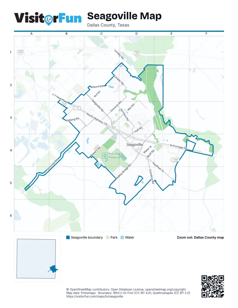
Street index of Seagoville
Each street on the sheet and the grid squares it crosses.
- C F Hawn FreewayB2, B3, D3, D4
- South Belt Line RoadA5
- North Highway 175B3, C3, D3, D4
- Seagoville RoadC2, C3
- East Malloy Bridge RoadE2, D3, E3, D4
- West Malloy Bridge RoadD4, C5, D5
- South Highway 175D4, E4
- North Frontage RoadE4, F4
- Kaufman StreetE5
- Farm-to-Market Road 1389E4, E5
- West Simonds RoadB3, C3, B4, A5
- East Farmers RoadC3, D3, D4
- East Simonds RoadD2, C3, D3
- Alto RoadD2, C3, D3
- Hall RoadD3, D4
- North Kaufman StreetC3, D4
- South Kaufman StreetD4, E4, E5
- Kleberg RoadB3, C3
- Combine RoadD4, D5
- Lasater RoadC2, D2
- West Stark RoadB3
- Shannon RoadC1, D1, C2, D2
- South Woody RoadB2
- West Bluff RoadD4
- Lumley RoadD1
- Bowers RoadB4, C4
- Ballard RoadD4, D5
- Stark RoadC2
- Ard RoadC2, B3, C3
- East Bluff RoadD4, E4
- Shady LaneD3
- Environmental WayC3, C4
- Fran StreetC4, D4
- East Stark RoadB2, C2, B3
- Water StreetD4
- Cloverhill LaneB3
- Judy LaneD3, D4
- Creekside CircleC3
- Catherine LaneD3
- Irene StreetD5
- South Watson StreetD4
- May RoadC3, D3
- North Watson StreetD4
- Casa Grande DriveD3
- Old Farm DriveC2, D2
- Netherland DriveC4
- Crestview DriveD3, D4
- Jack StreetD3
- Ross LaneD3
- Shadywood LaneD4
- Armstrong RoadC4
- Cobb RoadC5, D5
- West Farmers RoadD4
- Shadybrook LaneD3
- Seago DriveC4, D4
- Georgia LaneD4, E4
- Thedford RoadD3
- Lone Star LaneC2, D2
- Preakness DriveC2
- Pedigree LaneC2
- High School DriveD3
- Glenn StreetB3
- Durham StreetD4
- Old Wilmer BridgeA5
- Henley DriveC2, D2
- Wynngate DriveC2, D2
- Zoppes Mobile Manor Mobile Home ParkB3, C3
- Cain StreetC3
- Posey DriveD2
- Highland Meadows DriveC1, D1, D2
- Wooley WayC3
- Bent Tree RoadD5
- Quinette DriveD3
- Lynell DriveB2, B3
- Fairview AvenueD3, D4
- Baker StreetD4, D5
- Elmo DriveC4
- Greenhaven DriveC3, D3
- Woodhaven DriveC3, D3
- Aqueduct DriveC3, D3
- Modene StreetC3
- Johnson StreetD4
- Smith LaneD3, D4
- Quail Run DriveB3
- Easy StreetD5
- Cypress StreetD4
- Oakhurst DriveB3
- Flowers StreetD4
- Prescott LaneC2
- Briarbrook DriveD1, D2
- Bruce WayC3, C4
- Willis DriveE4
- Parkhaven DriveC3, D3
- Highland DriveD3, D4
- Riverview LaneD3
- Woodside LaneD3
- Saint Andrews DriveD2
- Grandview AvenueD3
- Glendale AvenueD4
- Avenue CD4
- Aberdeen DriveD2
- Marotto WayD2
- Thistlewood DriveD1, D2
- Myers StreetC3
- Dakota LaneD3
- Elizabeth LaneC3
- Riley DriveD4
- Balleywood DriveD2
- Canterbury DriveC3
- Jean DriveD3
- Delta Downs DriveC3, D3
- North Railroad AvenueD4
- Palomino LaneC2
- Horseshoe LaneC2
- Prentice DriveB3
- Stafford DriveC4, D4
- Altom LaneC3
- Mary Jane LaneD3
- Thomas TrailD3
- Cubley DriveC3
- Castlebend DriveD1, D2
- Kentucky TrailC2
- Wanda WayB2, B3
- Reeves LaneD3
- Bluffview DriveD3
- Walnut DriveB3
- Colt CourtD2
- Oakbrook LaneD3
- Mustang WayC2
- Hialeah DriveC3, D3
- Bryan PlaceD3
- Whitaker DrD2
- Meadow Grove DriveD4
- Midway StreetC2
- May Road CircleD3
- Stallion StreetC2
- Belmont DriveC3, D3
- Kristof DriveC2
- Mathis StreetD4
- Dennis CircleB3
- Julie StreetD3
- Shelby DriveD3
- Tahoe DriveC2
- Highgate DriveC2, D2
- Melrose DriveC2
- La Fonda DriveD3
- Pheasant LaneB3
- Baylee StreetD3
- Stonegate DriveC2
- Fly StreetD4
- Edge StreetD4, D5
- Tobin DriveC3, D3
- Hutchins DriveD2
- Clay LaneD3
- Derby DriveC2
- Stacie LaneD3, D4
- Creekstone CourtD3
- Lakey RoadD4
- Rowland DriveD2
- Englenook DriveD2
- Erle StreetD3
- Kim CircleB3
- Horton DrD2
- Madison DriveC3
- Paul DriveD3
- Campbell StreetC3
- Cundiff DriveD4
- Brittany WayD3
- Crosscreek LaneD3
- Avenue BD4
- Churchhill Downs DriveC3
- Kelly StreetC3
- Terrace LaneC3
- Jeff Davis DriveC3
- Dakota CircleC2, C3
- Johnnie RowD3
- Fisk RoadB3
- Moore RoadC4
- Barry DriveE4
- Ferrell DriveC3
- Joshua DriveD3
- La Salle DriveC3
- Homestretch DriveC2, D2
- Fawn Meadow DriveD3
- Jordan DriveD2
- Robinwood DriveB3
- Rosslyn CourtC1, D2
- Bell StreetC3
- Post Oak DriveB3
- Hammet DriveD3
- Vickie DriveE3, E4
- Gallop RoadC2
- Glenrose DriveD2
- Kimberly DriveC3
- Stockton DriveD2
- Alvarado DriveD3
- Graystone CourtD1
- Circle DriveC3
- Arlington Park CourtC3
- Hanover LaneD3
- Lincoln CircleC3
- Ball StreetD4
- Carriage CourtD2
- Emely LaneD3
- Pearl StreetC3
- Travis TrailC3
- Makanya LaneD3
- Old Seagoville RoadC3
- Tunnell StreetC3
- Allie Renea LaneD4
- West Adkins StreetD4
- Marie DriveD3
- Grande RoadD2
- Hopkins StreetC3
- Pinecrest DriveB3
- Broken Bow DriveC2
- Hollywood DriveC3, D3
- Hitt StreetD4
- Potter StreetC3
- Wilson StreetD3, C4
- Larry DriveE4
- Fountain DriveC3
- Simonds RoadA5, B5
- Scott PlaceB3
- Sunrise CircleC3
- Keeneland DriveD3
- Eastgate DriveD3
- Newsted DriveD3
- Putnam DriveD4
- Victor DriveE4
- Wade StreetC4
- Gibson StreetD4
- Sam Houston DriveC3
- Ulrich DriveD3
- San Jacinto DriveC3
- South Crestview DriveD4
- Trujillo DriveD3
- Avalon DriveD4
- Frances StreetC3
- Saratoga DriveD3
- La Fonda CircleD3
- Bilindsay RoadA5
- Van StreetE3, E4
- Brandon DriveD3
- Chariot CourtD2
- Tradition DriveC2, D2
- East Adkins StreetD3, D4
- Clydesdale CourtC2
- Chestnut DriveD2
- Vincent DriveE4
- Lincoln CourtC3
- Gunner DriveC2
- West Elm StreetD4
- East Ard StreetD4
- Appaloosa DriveC2
- North Peck StreetD4
- Teasdale CourtC1, D2
- South Peck StreetD4
- Steeplechase LaneC2
- Edmonds DriveD3
- Del Carlo CircleD3
- Sierra DriveD3
- Coronado DriveC3
- St. Lawrence DriveD3
- Petrea DriveD2
- Phelps DriveD2
- Ontario DriveC2
- Apple StreetD3, D4
- Paddock LaneC2, D2
- Hillhaven DriveC3
- Furlong DriveD2
- Lauren WayC2
- Corbo DriveD2
- Old Rylie-KlebergB3
- Dunnbrrook CourtD1, D2
- Glen Cove StreetC3
- Page AvenueC3
- Rein RoadC2
- Cedar DriveB3
- Layton CourtD3
- Bowers StreetD4
- Hetfield DriveD3
- Kennedy AvenueC3
- Gladys StreetD4
- East Retha StreetD4
- Laurel Park LaneC2
- Continental AvenueC3
- Lexington StreetC3
- Scott StreetB3
- Naci CourtC2
- Huddleston CourtD3
- Heritage CourtD4
- Wisdom DriveD3
- Lundy LaneD3
- Hampton CourtD4
- Washington StreetD4
- Whitehaven StreetD4
- Bronco DriveC2, D2
- Burton DriveD3
- Shaye CourtD3, D4
Places on the map
- Ace Hardware
- American National Bank of Texas
- Anytime Fitness
- AutoZone
- Beardon Park
- Best Western
- Brookshire's
- Bruce Central park
- Central Elementary School
- Chevron
- Chevron Car Wash (Inc. Short-Visits)
- Chicken Express
- Creekside Circle
- Denny's
- Dollar General
- Federal Correctional Institution Seagoville
- Gibson Self Storage
- Heard Park
- Homebank Texas
- James Ray Henry Stadium
- Lee Cemetery
- McDonald's
- Methodist Church of Seagoville
- Murphy USA
- O'Reilly Auto Parts
- Post Oak Preserve
- Rose Lawn Memorial Gardens
- Seagoville C-Store
- Seagoville Church of Christ
- Seagoville Elementary School
- Seagoville Fire Station 2
- Seagoville Food Mart
- Seagoville Inn
- Seagoville Market
- Seagoville North Elementary School
- Seagoville Police
- Shell
- Soil Conservation Service Site 4 Reservoir
- Soil Conservation Service Site 6 Reservoir
- Walmart Supercenter
© OpenStreetMap contributors, Open Database License, openstreetmap.org/copyright · Map data: Protomaps · Boundary: Who's On First (CC-BY 4.0); Quattroshapes (CC BY 2.0)















