

Texas map
Southlake map
About 31,500 people live here (Census Bureau, 2024 estimate). The sheet's index lists 300 streets; East State Highway 114, Northwest Parkway and North White Chapel Boulevard cross the most grid squares. Also on it: Bob Jones Park, Southlake Town Square and Timarron Golf Course.
Open the map (PDF, US Letter)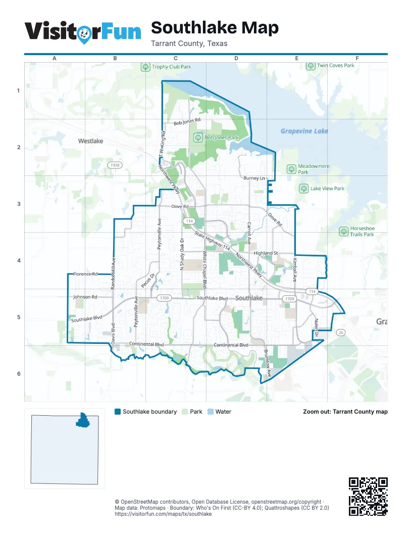
Street index of Southlake
Each street on the sheet and the grid squares it crosses.
- Northwest ParkwayC2, C3, C4, D4, E4, E5
- Northwest HighwayF5
- West Southlake BoulevardA5, B5, C5
- East Southlake BoulevardC5, D5, E5, F5
- Randol Mill AvenueB3, B4, B5
- Davis BoulevardB5, B6
- West Northwest HighwayF5
- East State Highway 114C2, C3, C4, D4, E4, E5, F5
- North White Chapel BoulevardC1, C2, C3, C4, C5
- Kirkwood BoulevardC2, C3
- North Carroll AvenueD3, D4, D5
- North Kimball AvenueE3, E4, E5
- South Kimball AvenueE5
- East Continental BoulevardC5, D5, E5, D6, E6
- East Dove RoadC3, D3, E3, E4
- West State Highway 114C3, C4, F5
- South Carroll AvenueD5
- South White Chapel BoulevardC5, C6
- West Continental BoulevardB5, C5
- West Dove RoadC3
- Brumlow AvenueD6, E6
- Sabre DriveC2
- Continental BoulevardC5, C6
- Solana BoulevardC2
- Dove RoadC3
- Pleasant Run RoadC6
- Byron Nelson ParkwayD5, D6
- East Kirkwood BoulevardC3, D3, D4, E4
- North Peytonville AvenueC3, B4, C4, B5
- Southridge Lakes ParkwayC4, C5
- North Shady Oak DriveC3, C4, C5
- East Highland StreetC4, D4, E4
- Burney LaneD2, D3, E3
- South Peytonville AvenueB5
- T.W. King RoadC1, C2
- Johnson RoadA5, B5
- Crooked Lane BoulevardE5, E6
- Lonesome Dove RoadE3
- Sunshine LaneE3, E4
- West Bob Jones RoadC2
- Blessed WayE4
- South Nolen DriveE5
- Union Church RoadA5, B5
- West Highland StreetC4
- Grace LaneD4
- Sam School RoadC3
- Pine DriveC5
- T.W. King Road EastC2
- Lilac LaneC5, D5
- Southmost DriveD4
- Nolen DriveE5
- North Nolen DriveE5
- Village Center DriveE5
- South Pearson LaneA5
- East Bob Jones RoadD1, C2, D2
- Unity WayC4, C5
- Bent Creek DriveC5, C6
- Woodbrook LaneB4, C4
- Saddleback LaneC1, C2
- Florence RoadA4, B4
- Brazos DriveC4
- Shady LaneE4, E5
- Stratford DriveC5
- Eagle BendC6, D6
- Pecos DriveB4, C4, B5, C5
- Schwab LaneC2, C3
- Winding Ridge TrailB5
- Lake Carillon LaneD3, D4
- Turnberry LaneC3, C4
- Lakeview DriveB4
- Clariden Ranch RoadC2
- Ridgecrest DriveD2, D3
- Jellico CircleB5
- Stone Lakes DriveC5
- Commerce StreetE5
- Aberdeen WayD6
- Watermere DriveA5, B5
- Main StreetD5, E5
- Diamond BoulevardD4, D5
- Marshall RoadC3
- Chesapeake LaneA5
- Raintree DriveE4
- Indian Paintbrush WayB5
- Dominion DriveD5
- Zena Rucker RoadD5
- Independence ParkwayC5
- Silicon DriveE5
- Timber Lake DriveC5
- State StreetD4, D5
- Regency CrossingD6
- Village Green DriveB5, B6
- Shorecrest DriveC5
- Aspen Ridge DriveD3
- Deer Hollow BoulevardB5
- Dove Creek TrailD4
- Top Rail LaneB5
- Emerald BoulevardC4, D4, D5
- Quail Run RoadD3
- Longford DriveD5
- Northridge DriveB5, C5
- Canyon Park DriveD3
- Lake DriveD2, E2, D3
- Orleans DriveD3, D4
- Wentwood DriveD5
- Merlot DriveD5
- West Chapel Downs DriveC4
- Morgan RoadB3, B4
- Normandy DriveC5
- Southwestern StreetE6
- Estes Park DriveD3
- King Ranch RoadC2
- Boulder DriveD3
- Riviera LaneD3, D4
- Mission DriveC4, D4
- Brookshire DriveE5
- Park Grove LoopB5
- Cross Timber DriveB4, C4
- McCrae TrailD3
- Mockingbird LaneB3, C3
- Sunrise Ranch RoadC2
- Round Hollow LaneC2, C3
- Villa PromenadeD6
- la Salle LaneD3, D4
- Timber Lake WayC5
- Bay Meadows DriveD3
- Division StreetD4, E4
- Montgomery LaneD6
- Westwood DriveE5
- Tuscan Ridge CircleB3
- Canyon Lake DriveC5
- Creekway BendC6
- Sherwood DriveC4
- Powder River TrailD3
- Stacy DriveC4, C5
- Loch Meadow CourtD2, D3
- Fairway View TerraceD6
- Emerald CircleD3, E3
- South Field DriveC2
- Tyler StreetC3
- Timber Lake CircleC5
- Pheasant LaneB3, C3
- Saint Tropez DriveD3
- Hampton Manor WayC4
- Meadowlark LaneB4, B5
- Water Lily DriveB4
- Southview TrailD4, D5
- Taylor StreetD3
- Stonebridge LaneB5
- Lodestar DriveB4
- Harrell DriveA5
- Northwood TrailD5
- Ten Bar TrailB4
- Chimney Hill TrailB5, C5
- Dartmouth DriveC5
- Hat Creek TrailD3
- Bent Trail CircleC6
- Creekside DriveE3, E4
- Inwood DriveD5
- Lovegrass LaneB4, B5
- Stockton DriveC3
- Imperial AvenueD4
- Riverbrook WayA5, B5
- Briar LaneC2, D2
- Hanover DriveD5
- Overland TrailA4, A5
- Cimarron TrailA4, A5
- Beam DriveB4
- Pearl DriveD4, D5
- Central AvenueE4, D5
- Siena DriveB5
- Woodsong WayD5
- Laurel LaneC3, B6
- Monte Carlo DriveD3
- Cheyenne Park LaneD3
- Federal WayD4, D5
- Ownby LaneD4, D5
- Potomac PlaceC5, C6
- Eastwood DriveE5
- Highland Oaks CircleC5, D5
- Foxborough LaneD5
- Coyote RoadC2
- Kimball ParkE4
- Stonebury DriveB5
- Southlake Park RoadD2
- Rhone LaneD3, D4
- Westmont DriveD5
- Veranda LaneA5, B5
- Exchange BoulevardE5
- Freedom LaneC5
- Amelia Island PathC3
- Bent Wood LaneD4
- Lake Crest DriveC5
- Sleepy HollowB4, C4
- Brooks CourtD2
- Strathmore DriveD5, D6
- Summit Ridge DriveD3
- Lake Wood DriveD4
- Sam Bass Ridge RoadC1
- Cherry LaneE4
- Lorraine DriveD5
- Province LaneD6
- Cotswold Valley CourtE4
- Castle Rock DriveD3
- East Chapel Downs DriveC4, D4
- Love-Henry CourtC4
- Biltmore DriveB4
- Grand AvenueD4, D5
- Morningside DriveD5
- Market LoopE5
- Saxon TrailD5
- Midland Creek DriveD5
- Timarron Golf CourseD6
- Royal Oaks CourtE3
- Simmons CourtE4
- Ridgewood CircleC5, C6
- Saratoga DriveD4
- Wyndsor Creek DriveD5
- Giverny LaneD3
- Post Oak TrailC4
- Oak Bend CourtD3
- Canopy CourtE4
- Tucker DriveD2
- Highland Oaks DriveC5, D5
- Flamingo CircleD2, D3
- Garden CourtC3
- Kingswood DriveB4
- Bordeaux DriveD5
- Berkshire RoadC4
- Lexington TerraceC4
- South Hollow DriveE5, E6
- Palmetto WayC3
- Wyndham Hill LaneC6
- Metairie LaneC3
- Trail Dust DriveB4, B5
- Midway DriveE2, E3
- Heatherglen DriveD5
- Ranch Loredo TrailC2
- Greenbough LaneE4
- Keystone DriveC3, D3
- Hillside CourtB4
- Welford LaneC2, C3
- Woodsey CourtE6
- Montrose LaneC4
- Redwing DriveB4
- Alamo DriveD4
- Moss LaneE3, E4
- Chimney Works DriveB5
- Soda Ridge RoadC1, C2
- Camden CircleB4
- Regal Oaks DriveB3
- Pyrenees DriveD3, D4
- Timberline CourtE6
- Wheeler DriveC3
- Bryson WayD5
- Harbor Retreat StreetD2, D3
- Londonberry TerraceC5
- Rolling LaneE4
- Savannah TrailC3
- Gifford CourtB4
- Palladium BoulevardD3
- Park Vista CircleC5
- Fanning StreetB4
- Ashleigh LaneD5
- Cascade Springs DriveD5
- TD Ameritrade LaneC2, C3
- Westminster WayE5
- Ravenaux DriveC4
- Miracle Pointe DriveE5
- Winchester DriveC4
- Plantation DriveC3
- Parkview LaneC5
- Rainforest CourtE4
- Harbor Haven StreetD2
- Hunters Creek StreetD3, E3
- Bank StreetF5
- Homestead DriveD1, D2
- Haven CircleD5, D6
- Greenbriar DriveB5
- Whispering LaneD4
- Hillcrest TrailC5
- Vista TrailA4
- Summer Place LaneD4
- Coventry LaneC4
- Forest Hills DriveD5
- Le Mans LaneD3, D4
- Briarwood DriveE4
- Southbend TrailD4
- Woodland DriveD2
- Matador Ranch RoadC2
- Sutton PlaceA4
- Logans LaneD6
- Mesquite RoadB4
- Silverton StreetD3
- Charleston DriveC3
- Fox GlenC3
- Parkcrest DriveC5
- Carlisle LaneD5
- Maranatha WayB3, B4
- Donley CourtB4, B5
- Rainbow StreetD5, E5
Places on the map
- 7-Eleven
- American Threads
- Ann Taylor
- Anthropologie
- Apple Store
- Barnes & Noble
- Bicentennial Park
- Bob Jones Park
- Carroll Elementary Park
- Carroll High School
- Carroll Middle School
- Carroll Pointe
- Carroll Senior High School
- Chesapeake Park
- Dawson Middle School
- Dragon Stadium
- Florence Elementary School
- Gateway Park
- Gateway Plaza
- Goode Airport (Historical)
- Kimball Crossing
- Liberty Park at Sheltonwood
- North Park
- Oak Pointe Park
- Old Union Elementary School
- Park Village
- Public Storage
- Royal and Annie Smith Park
- Shops of Southlake
- Southlake Corners
- Southlake Public Library
- Southlake Town Square
- Stone Lakes Pond
- The Preserve
- The Westin Dallas Southlake
- Timarron Golf Course
- Varispace Southlake
- Walnut Grove Elementary School
- White's Chapel United Methodist Church
- Wyndham Plaza
Next to Southlake
- Westlake
© OpenStreetMap contributors, Open Database License, openstreetmap.org/copyright · Map data: Protomaps · Boundary: Who's On First (CC-BY 4.0); Quattroshapes (CC BY 2.0)















