

Texas road map
Texas highway map
21 Interstate routes run about 3,425 miles in Texas, each on a sheet of its own. The sheet's index lists 72 highways; I-10, I-20 and US 77 cross the most grid squares. Towns on it: Houston, San Antonio and Dallas.
Open the map (PDF, US Letter)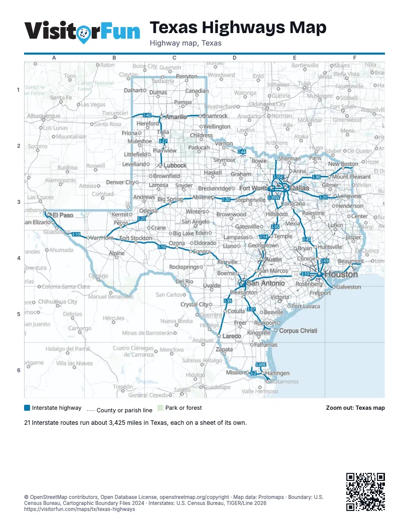
Road maps of Texas
21 road maps: each Interstate and byway on a sheet of its own.
Highway index of Texas
Each highway on the sheet and the grid squares it crosses.
- I-2D6
- I-10A3, A4, B4, C4, D4, E4, F4
- I-14D4, E4
- I-20B3, B4, C3, D3, E3, F3
- I-27C1, C2, D5
- I-30E3, F2, F3
- I-35D4, D5, E2, E3, E4
- I-35EE3
- I-35WE3
- I-37D4, D5, E5
- I-40B1, C1
- I-44D2
- I-45E3, E4, F4, F5
- I-69E4, F4
- I-69CD5, D6
- I-69ED5, D6, E5, E6
- I-69WD5
- I-110A3
- I-169E6
- I-369F2
- I-410D4, D5
- I-610E4
- I-635E3
- I-820E3
- US 54A3
- US 59D5, E4, E5, F2, F4
- US 60C1, C2
- US 62C2
- US 66B1, C1
- US 67B4, C3, E3
- US 69E2, F4
- US 70D2
- US 75E2, E3
- US 77D5, D6, E2, E3, E5, E6
- US 80E3, F3
- US 81D2, E3
- US 82C2, D2, E2
- US 83D3, D4, D5, D6, E6
- US 84C2, C3, D3, E3
- US 85A3
- US 87C1, C2, C3, D4
- US 90D4, E4, F4
- US 96F4
- US 175E3
- US 180A3
- US 181D5, E5
- US 183D2, D4
- US 190D4, E4
- US 259F3
- US 271F3
- US 277C3, D2, D3
- US 281D2, D4, D5, D6
- US 283D2
- US 287C1, D2, E3, F4
- US 290D4, E4
- US 377E3
- US 380E2
- US 385B4
- TX 6E3, E4
- TX 45D4, E4
- TX 71D4, E4
- TX 99E4, F4
- TX 114E3
- TX 121E2, E3
- TX 130D4, D5, E4
- TX 158C3
- TX 183E3
- TX 191C3
- TX 249E4
- TX 288E4, E5
- TX 375A3
- PA 1502D4
Places on the map
- Abilene
- Alpine
- Amarillo
- Andrews
- Anna
- Austin
- Beaumont
- Beeville
- Big Lake
- Big Spring
- Boerne
- Bowie
- Breckenridge
- Brownfield
- Brownwood
- Bryan
- Canadian
- Center
- Childress
- Conroe
- Corpus Christi
- Corsicana
- Cotulla
- Crane
- Crystal City
- Dalhart
- Dallas
- Del Rio
- Denver City
- Dumas
- Eden
- El Paso
- Eldorado
- Falfurrias
- Fort Stockton
- Fort Worth
- Freeport
- Freer
- Friona
- Galveston
- Gatesville
- Georgetown
- Gilmer
- Graham
- Harlingen
- Haskell
- Henderson
- Hereford
- Hillsboro
- Houston
- Huntsville
- Jasper
- Kermit
- Kerrville
- Kingsville
- Lamesa
- Lampasas
- Laredo
- Levelland
- Littlefield
- Llano
- Longview
- Lubbock
- Lufkin
- Mexia
- Mission
- Mount Pleasant
- Muleshoe
- New Boston
- Odessa
- Ozona
- Paducah
- Palestine
- Pampa
- Paris
- Pecos
- Perryton
- Plainview
- Pleasanton
- Port Lavaca
- Rockport
- Rocksprings
- Rosenberg
- San Angelo
- San Antonio
- San Elizario
- San Marcos
- Seymour
- Shamrock
- Sherman
- Snyder
- Sonora
- Stephenville
- Temple
- Tulia
- Uvalde
- Van Horn
- Vernon
- Victoria
- Wellington
- Winters
- Zapata
© OpenStreetMap contributors, Open Database License, openstreetmap.org/copyright · Map data: Protomaps · Boundary: U.S. Census Bureau, Cartographic Boundary Files 2024 · Interstates: U.S. Census Bureau, TIGER/Line 2026















