

Texas map
Wichita Falls map
About 102,372 people live here (Census Bureau, 2024 estimate). The sheet's index lists 300 streets; Trinidad Drive, Central Freeway and Central East Freeway cross the most grid squares. Things to do inside the boundary: Red River Valley and River Bend Nature Center.
Open the map (PDF, US Letter)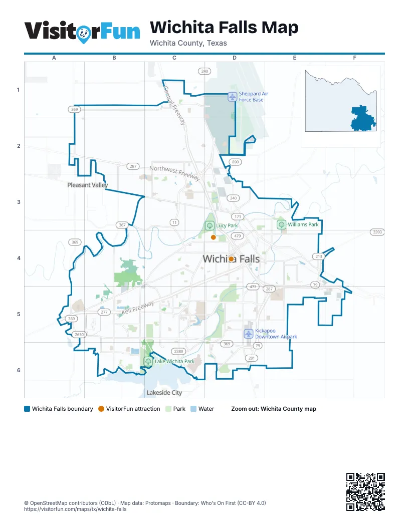
Street index of Wichita Falls
Each street on the sheet and the grid squares it crosses.
- Central FreewayC1, C2, C3, D3, D4
- Central East FreewayD4, E4, D5, E5, F5
- Southwest ParkwayA5, B5, C5, D5, D6
- Kell FreewayC4, D4, A5, B5, C5
- Northwest FreewayA2, B2, C2, C3
- Henry S Grace FreewayD4, D5, E5, D6
- Kell East BoulevardC4, D4, A5, B5, C5
- Waurika FreewayE4, F4, E5
- Old Jacksboro HighwayD4, D5, D6
- Lloyd Ruby OverpassD4
- Seymour HighwayB4, C4, D4, B5
- Kell West BoulevardC4, D4, A5, B5, C5
- Loop 11C2, C3, C4
- Burkburnett RoadC1, D1, D2, D3
- Sheppard Access RoadD2, D3
- Martin Luther King Jr. BoulevardD3, D4, E4
- Airport DriveC2, D2
- East Scott AvenueD4, E4
- Avenue ED1, D2, C4, D4
- Avenue DD1, D2, C4, D4
- Broad StreetD4
- Brook AvenueD4
- Archer City HighwayD6
- 6th StreetD3, D4
- Holliday StreetD4
- 5th StreetD3, D4
- North Martin Luther King Jr. BoulevardD3
- East Scott StreetE4
- Jacksboro HighwayD6
- Kemp BoulevardC4, D4, C5, C6
- Midwestern ParkwayC5, D5
- Reilly RoadA1, B1, C1
- Old Iowa Park RoadB3, C3, D3
- Fairway BoulevardB4, B5, B6
- Galveston StreetD4, E4
- Call Field RoadB5, C5
- Arena RoadA4, A5
- Spur 325 Frontage RoadC2, D2, C3
- FM 369 NorthA2
- Scott AvenueD3, D4
- North Scott AvenueD3
- FM 367B3, C3
- Sisk RoadA5, A6
- Emanual Davis BoulevardD4
- Allendale RoadB5
- Lincoln StreetD3
- Petrolia RoadE4
- Marconi StreetD4, E4
- Kell BoulevardD4
- Valley View RoadC3, C4
- State Highway 79F4
- Midwestern Parkway EastD5, E5
- Emanual Davis OverpassD4
- Central Freeway EastD4
- Barnett RoadB4, B5, B6
- Old Windthorst RoadE4, E5, E6
- Maplewood AvenueC5, C6
- 9th StreetC4, D4
- Missile RoadC1, D1
- Taft BoulevardD4, C5, D5, C6
- City View DriveC1, C2, C3
- Wellington LaneB1, B2, B3, B4
- 10th StreetC4, D4
- Harrison StreetD4, D5
- Huntington LaneB1, B2
- Harding StreetD4, E4
- McNiel AvenueC4, C5
- McKinney RoadE4, E5
- Cypress AvenueB5, B6
- Speedway AvenueC4, D4, C5
- North Beverly DriveC3, C4
- Seymour RoadB4, C4
- Rhea RoadC5, C6
- West Rathgeber RoadD6
- Lake Park DriveD5, C6, D6
- Rathgeber RoadD6, E6
- 11th StreetD4
- Trinidad DriveD3, C4, D4, B5, C5, D5, B6, C6, D6
- East Hatton RoadD5, E5
- Hammon RoadE4, E5
- Avenue KD2, C4, D4
- 7th StreetD3, D4
- Langford LaneB6
- Hampstead LaneC5, D5
- Maurine StreetC3, D3
- Lawrence RoadC4, C5
- Gregg RoadB5, B6
- Armory RoadD4, D5
- River RoadE3
- Lake Shore DriveB6
- Fisher RoadF4, F5
- Holliday RoadD4, D5
- Bridge Creek DriveC5, C6
- Johnson RoadB5
- North Rosewood AvenueE3, E4
- Armstrong DriveD2
- Stone Lake DriveD5, D6
- 3rd StreetD3, D4
- Lebanon RoadC4, C5
- Beverly DriveC4
- Hemme RoadC1
- Weeks StreetD5
- Rowland RoadE4
- Norman StreetD5
- South Rosewood AvenueE4
- Duncan StreetD3, E3
- Jefferson StreetD3
- Hatton RoadD5
- Taft StreetD4
- East Jefferson StreetD3
- East 3rd StreetD3
- FM 171D3
- Colorado AvenueE4
- Bacon Switch RoadC1
- Kiel LaneB2, C2
- Old Burk HighwayD2, D3
- Grant StreetC4, C5
- Avenue JD1, D2, C4, D4
- Buchanan StreetC4, C5
- Fillmore StreetC4, D4
- 8th StreetC4, D4
- Avenue HD1, D2, C4, D4
- Bluff StreetD4, D5
- York StreetC4, B5, C5
- Avenue GD1, D2, C4, D4
- Polk StreetC4, D4
- Garfield StreetC4, C5
- Travis StreetD4, D5
- Avenue ID1, D2, C4, D4
- Avenue FD1, D2, C4, D4
- Turtle Creek RoadB4
- Burnett StreetD4
- Taylor StreetC4, D4
- Hooper DriveC1, C2
- Kovarik RoadA4, B4
- Collins AvenueD4
- Van Buren StreetD4
- East Fort Worth StreetE4
- University AvenueB5, C5
- Hampton RoadE4, F4
- Austin StreetD4
- California AvenueD4, D5
- Cunningham DriveC5
- Wenonah AvenueC4, C5
- Grace StreetD4, D5
- Kessler BoulevardC4
- Lamar StreetD3, D4
- Hayes StreetC4
- Ridgemont DriveB4, C4
- 12th StreetD4
- Bonny DriveD5, D6
- Weeks Park LaneD5
- Denver StreetD4
- Monroe StreetC4, D4
- Featherston AvenueC5
- Baylor StreetD4
- Avenue CD1, D2, C4, D4
- Falcon BoulevardC1, C2
- Cartwright RoadB1, B2
- Indiana AvenueD3, D4
- Nehls BoulevardD2
- Ohio AvenueD3, D4
- 9th AvenueC1, D1
- Childress StreetD2
- Hamilton BoulevardD4, D5
- Hughes DriveC5
- 30th StreetD5
- Stearns AvenueC5
- Covington StreetC3
- Roanoke DriveC3, D3
- Ridgeway DriveC3
- Bridwell StreetD4, D5
- 4th StreetD3, D4
- Lindale DriveB5
- Tilden StreetC4
- Evergreen DriveC2, D2
- 1st AvenueD2
- Santa Fe StreetC4
- 14th StreetD4
- Avenue LC4, D4
- Elizabeth AvenueD4
- Radio LaneC3
- Arthur StreetC4, C5
- Martin BoulevardD4, D5
- Lavell AvenueC5
- 13th StreetD4
- Barbados StreetC5, D5
- Cynthia LaneD5
- Berkley DriveC5, D5
- Bridwell RoadD1
- Christine RoadD5
- Victory AvenueD4
- Elmwood AvenueC5, C6
- Shepherds GlenC5, C6
- McGaha AvenueC5
- McGregor AvenueD4
- East Midwestern ParkwayE5, F5
- Lucile AvenueD4
- Anchor RoadB4
- Moffett AvenueC5
- Glenwood AvenueC4, C5
- Longview StreetC2, C3
- Cumberland AvenueC4
- Phillips DriveB5, C5
- Boren AvenueC5
- Ellingham DriveC5, D5
- Kingston DriveB5, B6
- Ditto LaneD5, D6
- Polaris StreetC1, C2
- Wendover StreetB5, C5
- East Lincoln StreetD3, E3
- Clarinda AvenueC5, D5
- Duval StreetD4
- Professional DriveD6
- Colquit RoadC4, C5
- Louis J Rodrigues DriveC5
- Shady LaneB4, C4
- Amherst DriveC5, C6
- Beaumont StreetD2
- Fell LaneB3
- Flood StreetD4, E4
- Sunset DriveD3, D4
- Borton StreetC3, D3
- Parkhill RoadB4, B5
- Pearl AvenueD4
- Kiel RoadA2, B2
- Prince Edward DriveC5
- 31st StreetD5
- 32nd StreetD5
- Hines BoulevardE4
- South Shepherds GlenC6
- Briargrove DriveB5
- Giddings StreetD4
- Ardath AvenueD4
- 15th StreetD4
- Keeler AvenueD4
- Cedar Elm LaneD5
- Tuskegee Airmen AvenueD2
- North Broadway StreetD3, D4
- Alamo DriveD5
- Hollandale AvenueD5
- Humphreys StreetD4, E4
- Kentucky AvenueD4
- Jacqueline RoadC3
- Anderson DriveD2
- Hursh AvenueD5
- Skaggs DriveD2
- 35th StreetD5
- Peach StreetE4
- Reginald DriveC6
- Tulsa StreetD3, D4, E4
- Wichita StreetD3
- Marshal StreetD4
- Huff StreetD4
- Mesquite StreetD5, D6
- Sherman RoadC4, C5
- Tinker TrailC1
- Cedar AvenueC4
- Red Fox RoadC3, D3
- Candlewood CircleC6
- Lee StreetD3, D4
- Stesco AvenueE4
- Avondale StreetD4, D5
- Greenbriar RoadD5, D6
- Perigo StreetE4
- 3rd AvenueD2
- Bell StreetD4
- Quincy RoadE5
- Dallas StreetD4, E4
- Sinclair BoulevardD3
- Jalonick StreetD4, E4
- Jasper StreetD4, D5
- Jennings AvenueA5, B5
- North Brook AvenueD3, D4
- Blanton StreetC5
- Whisper Wind DriveB6
- Pleasant View DriveD3
- Harlan AvenueC3
- Avenue BD1, C4, D4
- Farris StreetD3
- Berwick DriveC4, C5
- Mistletoe DriveB5
- Morgan LaneE4
- Northwest DriveC3
- 2nd StreetD3, D4
- Harris LaneC3
- Onaway TrailC4
- Bayberry DriveB6
- Borland LaneB3
- Fairfax AvenueC2, D2
- Waco StreetD4, E4
- Woods StreetD3, E3
- 23rd StreetD4
- Fort Worth StreetD4, E4
- Mississippi AvenueD4
- Southwest DriveC3, C4
- Carolina StreetD3
- Pole StreetD1
- Crescent LaneC3
- Edgecliff DriveD6
Things to do on the Wichita Falls map
Places on the map
- Armstrong Drive
- Barwise Middle School
- Ben Donnell Park
- Castaway Cove Waterpark
- City of Wichita Falls Lake
- City View Elementary School
- City View Junior/Senior High School
- Crestview Memorial Park Cemetery
- Crockett Elementary School
- Denver Tank
- Dry Creek Mobile Home Park
- Expressway Village Park
- Fain Elementary School
- First Baptist Church
- Flying J Travel Center
- Fowler Elementary School
- Gabriella's Square
- Hamilton Park
- Harrell Park
- James V. Allred Unit
- Kickapoo Downtown Airpark
- Kiwanis Park
- Lake Wichita Park
- Loch Lomond
- Lucy Park
- Midwestern State University
- Parker Square Shopping Center
- Quail Creek Crossing
- Red River Hospital
- Sheppard Air Force Base
- Sikes Lake
- Sikes Lake Duck Park
- Sikes Senter Mall
- The Champions Course at Weeks Park
- Wichita Falls Country Club
- Wichita Falls RV Park
- Wichita Falls Sports Complex
- Wichita Square
- Williams Park
- World's Littlest Skyscraper
Next to Wichita Falls
- Lakeside City
- Pleasant Valley
© OpenStreetMap contributors, Open Database License, openstreetmap.org/copyright · Map data: Protomaps · Boundary: Who's On First (CC-BY 4.0); Quattroshapes (CC BY 2.0)















