

Texas map
Wood County map
About 48,742 people live here (Census Bureau, 2024 estimate). The sheet's index lists 300 streets; Oil Field Road, State Highway 154 and South Main Street cross the most grid squares. Things to do inside the boundary: Mineola Historical Museum.
Open the map (PDF, US Letter)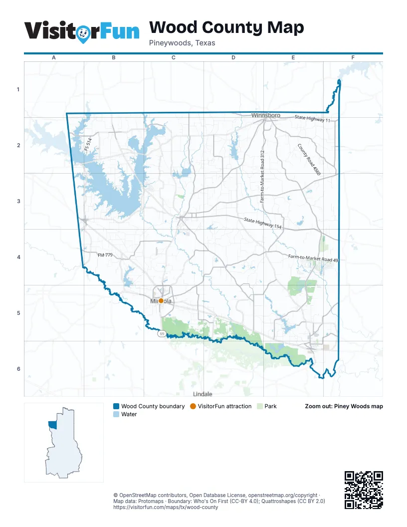
Street index of Wood County
Each street on the sheet and the grid squares it crosses.
- State Highway 154C3, D3, E3, E4, F4
- State Highway 37D2, C3, D3
- State Highway 11E1, E2, F2
- South Main StreetE1, B2, D2, E2, C3
- East Loop 564C5
- North Pacific StreetC4, C5
- Southeast Loop 564C5
- West Broad StreetC5
- West Loop 564C5
- East Broadway StreetE1
- North Main StreetE1, B2
- South Pacific StreetC5
- East Broad StreetC5
- Front StreetE6
- North Winnsboro StreetC3
- East Goode StreetC3
- Northeast Loop 564C5
- Greenville AvenueC5
- Northwest Loop 564C5
- East Greenville StreetA3, B3
- Dallas HighwayB5, C5
- West Broadway StreetD1, E1
- West Greenville StreetA3
- East Holley StreetA3, B3
- Farm-to-Market Road 1801C5, D5
- West Bermuda StreetC3
- East United States Highway 80C5
- West Holley StreetA3
- Main StreetC3
- Mineola HighwayC5
- Loop 564C5
- Farm-to-Market Road 49C4, D4, E4, F4, C5
- Farm-to-Market Road 2088C3, D3, E3, F3
- Farm-to-Market Road 778C4, D4, D5
- Farm-to-Market Road 852D1, E2, F2, F3
- Farm-to-Market Road 69C1, C2, C3
- Farm-to-Market Road 1795E5, F5
- Farm-to-Market Road 514A2, B2
- Horton StreetC3, C4
- Beaulah StreetE5, E6
- Farm-to-Market Road 2966C2
- East Coke RoadE2
- West Coke RoadD2, E2
- East Carnegie StreetE1, E2
- East McDonald StreetC5
- Gilmer RoadE2
- East Oak StreetB2
- West Oak StreetB2
- Grand Saline StreetB3
- North Walnut StreetE1
- Farm-to-Market Road 14E5
- FM 17A4, B4
- Oak Grove RoadC3
- Farm-to-Market Road 1804D5
- Farm-to-Market Road 2869E2, E3, E4, E5
- Farm-to-Market Road 312D2, E2, D3, E3, E4
- FM 779A4, B4, C4
- Farm-to-Market Road 1643D2, D3
- Farm-to-Market Road 1647F2
- County Road 3860E4, D5, E5
- Farm-to-Market Road 1254C4, D4, C5
- County Road 3859D4, D5
- County Road 3600E5, F5, E6
- Farm-to-Market Road 2422C5, D5
- County Road 2650C5
- FS 514B2
- North Newsom StreetC5
- Blackjack StreetD1, E1, B2
- South Walnut StreetE1, E2
- County Road 3500E5
- County Road 3480E5
- County Road 3400E6
- Glazner StreetE6
- Blackbourn StreetE6
- West Patten StreetC5
- County Road 4608E2
- Farm-to-Market Road 2455F2
- Ivey StreetC5
- East Quitman StreetA3, B3
- Mimosa StreetC5
- County Road 2651C5
- East Pine StreetE1
- County Road 3104C3
- County Road 3105C3
- Lane StreetC3
- North Osborn StreetB3
- Yates StreetE6
- Mount Pleasant StreetE1
- South Osborn StreetB3
- School DriveE6
- Goldsmith StreetC3
- North Chestnut StreetE1
- County Road 3501E5
- Old US Highway 80E6
- East Patten StreetC5
- Old Highway 80E6
- Cage StreetC5
- West Quitman StreetA3
- North Goldsmith StreetC3
- Farm-to-Market Road 2659F5
- Oil Field RoadC2, D2, C3, D3, C4, E6
- County Road 4560E2, E3, F3
- County Road 4930D2, D3
- County Road 1600B3, B4
- County Road 3420E5
- County Road 3990E3, E4
- County Road 3880D4, E4
- County Road 4660E2, E3
- County Road 3250D3, D4
- County Road 2100C3, B4, C4
- County Road 3230D3, D4
- County Road 3550E4, F4
- County Road 2724C5
- County Road 4990C2, D2, C3
- County Road 3540E4, E5
- County Road 3270D4
- County Road 3440E5, E6
- County Road 4460E2, F2
- County Road 2330C4
- Holly Trail EastE4, F4
- County Road 3940E4, E5
- County Road 3265D4
- County Road 1970B2, B3
- County Road 1476C1, C2
- County Road 2700C5
- County Road 4760D2, D3
- County Road 4870D2
- Holly TrailE4
- County Road 4294C1, C2, D2
- County Road 1630B3, B4
- County Road 3234D3
- County Road 4490E2, F2
- County Road 4596E3, F3
- County Road 3144D3
- County Road 4287D1, D2
- County Road 4530E2
- County Road 2260B4, C4, B5
- County Road 3118D3
- County Road 2336B4, C4
- County Road 1730B1, B2
- County Road 4778D3
- County Road 4450E2, F2
- County Road 4860D2
- Private Road 7850D5, E5
- County Road 1460C2
- Private Road 7908E5
- County Road 4420E1, E2
- County Road 4150D3
- County Road 1260C2
- County Road 3840D5, E5
- County Road 3588E3, F3
- County Road 4878D2
- County Road 4186D3
- Greenbriar TrailE4, F4
- County Road 1416C3
- County Road 2270B4
- County Road 4940C2, D2, C3, D3
- County Road 3235D3, D4
- County Road 1807B1, B2
- County Road 3750E6, F6
- County Road 1612B3, B4
- County Road 2389B4
- County Road 2332B4, C4
- County Road 4250D1, D2
- County Road 1560B3
- County Road 4750D2
- County Road 4580F3
- County Road 3689F5
- County Road 1700B1, B2
- County Road 3419E5, E6
- County Road 4430E1, E2
- County Road 2954B4
- County Road 4470E2, F2
- County Road 3220C3, C4
- County Road 3260D3, D4
- County Road 1410C3
- County Road 3590F3
- Rose Hill RoadC4
- County Road 3987E3
- County Road 1912B2
- County Road 3155D3
- County Road 4510E2
- County Road 3875D4, D5
- County Road 3170D3
- County Road 4730D2
- County Road 1388C2
- County Road 3978E3, E4
- County Road 4255D2
- County Road 3870D4
- County Road 4116C3, D3
- County Road 1800B1, B2
- County Road 3810E5
- County Road 3520F1, E5
- County Road 1900B2
- County Road 2980B4
- County Road 2385B4
- County Road 1570B3
- County Road 4165D3
- County Road 1497C2
- County Road 1468C2
- County Road 4840D2
- County Road 2495C2, D2, C4
- Holland DriveC4, C5
- County Road 3920E4
- County Road 1810B1, B2
- County Road 1590B3
- County Road 4480F2
- Private Road 7905E5
- County Road 1360C2
- County Road 2382B4
- County Road 2320C4
- County Road 2790D5
- County Road 1785A2
- County Road 1858B2, C2
- County Road 2810C5
- County Road 2230B4, B5
- County Road 2930B4
- County Road 1792A1, A2
- County Road 1813B1, B2
- County Road 2388B4
- County Road 4980D2
- County Road 4536E2
- Valleywood TrailE4
- County Road 1960B2
- County Road 4830D2
- West Myrtle StreetD1, E1, D2
- County Road 1698A4, B4
- County Road 1320C3
- County Road 3495E5
- County Road 3275D4
- County Road 4890D2
- County Road 4700D2
- County Road 4200D1, D2
- County Road 4865D2
- County Road 3832E5
- County Road 2380B4
- County Road 4390F1, F2
- County Road 1473C2
- County Road 2425C1, C4
- County Road 4805D2
- County Road 2267B4
- County Road 3245D3, D4
- County Road 2150C3, C4
- County Road 2774D5
- County Road 2590D4
- County Road 4280D2
- County Road 3953E4
- County Road 3900E5
- County Road 1226C3
- County Road 4919D3
- County Road 4627D2, E2
- County Road 1840B2
- County Road 2231B5
- County Road 2275B4
- County Road 3264D4
- County Road 2482C4
- County Road 1236C3
- County Road 1522B3
- County Road 1802B1, B2
- County Road 4583F3
- County Road 3986E3
- County Road 3490E5
- County Road 1580B3
- County Road 2377B4
- County Road 1540B3
- County Road 4620E2
- County Road 1660B4
- County Road 4645D3, E3
- County Road 4579E3, F3
- County Road 2210B5, C5
- County Road 2675D4
- County Road 4636E2
- CR 2290B4
- County Road 2339C4
- County Road 3950E4
- County Road 2952B4
- County Road 2944B4
- Private Road 7891D4
- Private Road 7402E5
- County Road 3163D3
- County Road 3430E5, E6
- County Road 2195C4
- County Road 3190E3
- County Road 2220C4, C5
- County Road 4661E2
- County Road 2310C4
- County Road 3580F3, F4
- Private Road 5980B3
- County Road 4440E2
- County Road 3226C4, D4
- County Road 4815D2
- County Road 2660D5
- County Road 2370B4
- County Road 1513A2
- County Road 2689D5, E5
- County Road 3955E4
- County Road 3287D4
- County Road 1336C3
- County Road 1350C2
- County Road 1210C3
Things to do on the Wood County map
Places on the map
- Adkins Lake
- Alba
- Alba-Golden ISD
- Beaver lake
- Big L Lake
- Big Woods Spring Lake
- Bobo Lake
- Boggy Lake
- Bradford Lake
- Brittain Lake
- Brooks Lake
- Brumley Lake
- Butler Lake
- Camp Lake
- Cedar Lake
- Childress Pond
- Creekside Air Park
- Crystal Lake
- Deep Eddy
- Floating Glade
- Greenbriar Lake
- Gunstream Lake Number 1
- Hawkins
- Holly Lake Ranch Golf Club
- Horseshoe Lake
- Lake Fork Reservoir
- Lake Hawkins
- Lake Holbrook
- Lake Lydia
- Lake Quitman
- Lake Winnsboro
- Little Sandy National Wildlife Refuge
- Mineola
- Mineola Nature Preserve on the Sabine River
- Oak Wood Shores
- Quitman
- Rock Falls Lake
- Upper West Lake
- Winnsboro
- Yantis
Next to Wood County
- Lindale
© OpenStreetMap contributors, Open Database License, openstreetmap.org/copyright · Map data: Protomaps · Boundary: Who's On First (CC-BY 4.0); Quattroshapes (CC BY 2.0)















