

United States map
United States map
The sheet's index lists 65 highways; I-90, I-10 and I-69 cross the most grid squares. Also on it: Albany, Anchorage and Annapolis. 55 smaller maps sit inside it, among them Alabama, Alaska and Arizona.
Open the map (PDF, US Letter)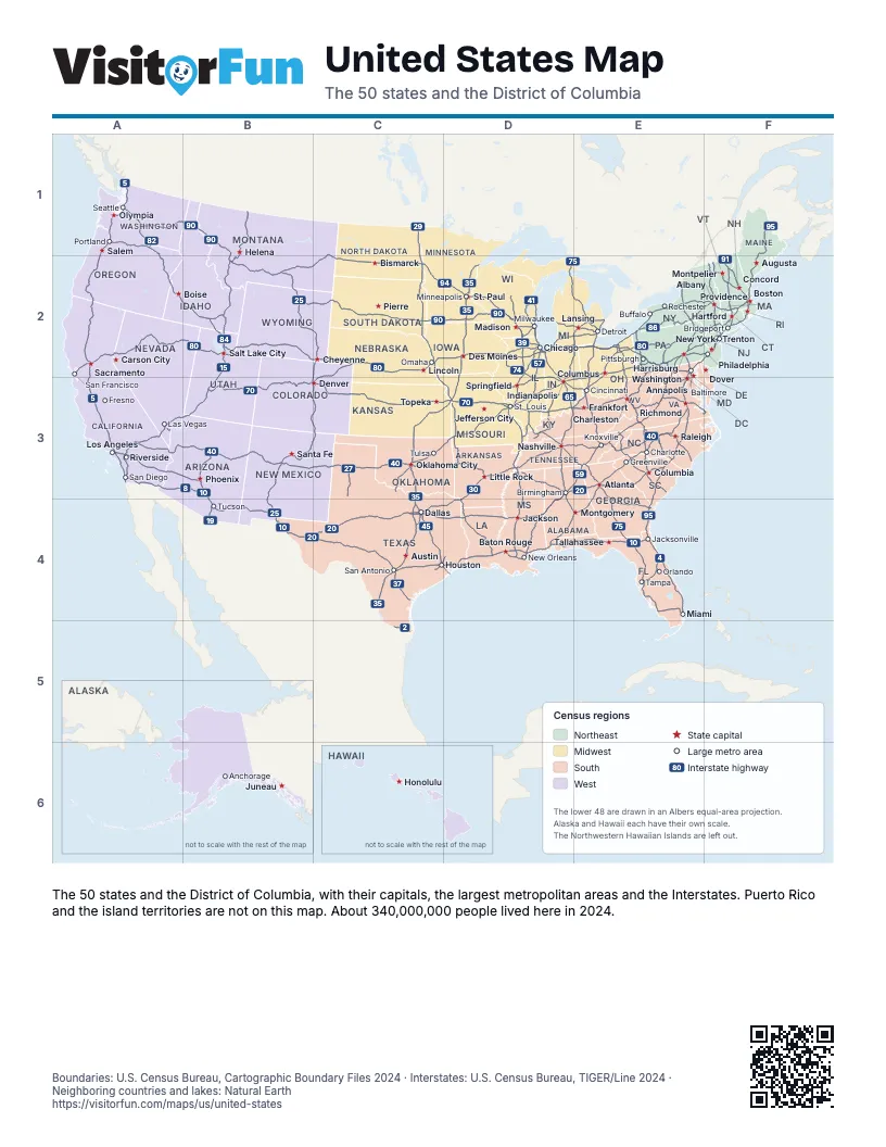
Maps inside United States
4 maps inside United States.
Highway index of United States
Each highway on the sheet and the grid squares it crosses.
- I-2C5
- I-4E4
- I-5A1, A2, A3
- I-8A3, B3
- I-10A3, B3, B4, C4, D4, E4
- I-11A3
- I-12D4
- I-14C4
- I-15A3, B1, B2, B3
- I-16E4
- I-17B3
- I-19B4
- I-20B4, C4, D3, D4, E3
- I-22D3
- I-24D3, E3
- I-25B2, B3, B4, C2, C3
- I-26E3
- I-27C3
- I-29C1, C2, C3, D3
- I-30C4, D3, D4
- I-35C3, C4, D2, D3
- I-37C4
- I-39D2
- I-40A3, B3, C3, D3, E3
- I-41D2
- I-43D2
- I-44C3, D3
- I-45C4, D4
- I-49D3, D4
- I-55D2, D3, D4
- I-57D2, D3
- I-59D3, D4, E3
- I-64D3, E3, F3
- I-65D2, D3, D4, E3, E4
- I-66E3
- I-68E2
- I-69C4, C5, D2, D3, D4, E2
- I-70B3, C3, D3, E2, E3
- I-71D3, E2, E3
- I-72D3
- I-73E3
- I-74D2, D3, E3
- I-75D2, E2, E3, E4
- I-76B3, C2, C3, E2, F2
- I-77E2, E3
- I-78E2, F2
- I-79E2, E3
- I-80A2, B2, C2, D2, E2, F2
- I-81E2, E3
- I-82A1
- I-83E2
- I-84A1, A2, B2, E2, F2
- I-85E3, E4
- I-86B2, E2, F2
- I-87E3, F2
- I-88D2, E2, F2
- I-89F2
- I-90A1, B1, B2, C2, D2, E2, F2
- I-91F2
- I-93F2
- I-94B2, C1, C2, D2, E2
- I-95E2, E3, E4, F1, F2
- I-96D2, E2
- I-97E2
- I-99E2
Places on the map
- Albany
- Anchorage
- Annapolis
- Atlanta
- Augusta
- Austin
- Baltimore
- Baton Rouge
- Birmingham
- Bismarck
- Boise
- Boston
- Bridgeport
- Buffalo
- Carson City
- Charleston
- Charlotte
- Cheyenne
- Chicago
- Cincinnati
- Columbia
- Columbus
- Concord
- Dallas
- Denver
- Des Moines
- Detroit
- Dover
- Frankfort
- Fresno
- Greenville
- Harrisburg
- Hartford
- Helena
- Honolulu
- Houston
- Indianapolis
- Jackson
- Jacksonville
- Jefferson City
- Juneau
- Knoxville
- Lansing
- Las Vegas
- Lincoln
- Little Rock
- Los Angeles
- Madison
- Miami
- Milwaukee
- Minneapolis
- Montgomery
- Montpelier
- Nashville
- New Orleans
- New York
- Oklahoma City
- Olympia
- Omaha
- Orlando
- Philadelphia
- Phoenix
- Pierre
- Pittsburgh
- Portland
- Providence
- Raleigh
- Richmond
- Riverside
- Rochester
- Sacramento
- Salem
- Salt Lake City
- San Antonio
- San Diego
- San Francisco
- Santa Fe
- Seattle
- Springfield
- St. Louis
- St. Paul
- Tallahassee
- Tampa
- Topeka
- Trenton
- Tucson
- Tulsa
- Washington
Boundaries: U.S. Census Bureau, Cartographic Boundary Files 2024 · Interstates: U.S. Census Bureau, TIGER/Line 2024 · Neighboring countries and lakes: Natural Earth















