

United States map
Southern United States map
The sheet's index lists 38 highways; I-20, I-40 and I-95 cross the most grid squares. Also on it: Abilene, Alexandria and Amarillo. 3 smaller maps sit inside it, among them East South Central States, South Atlantic States and West South Central States.
Open the map (PDF, US Letter)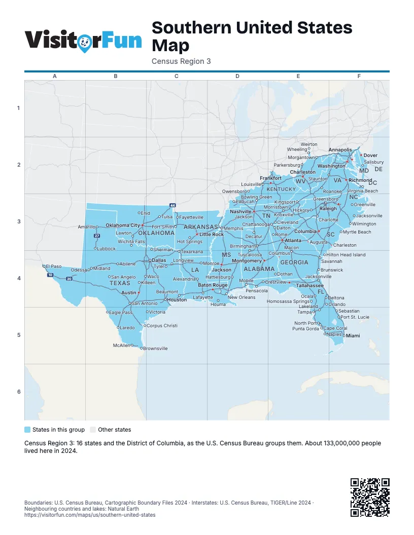
Maps inside Southern United States
3 maps inside Southern United States.
Highway index of Southern United States
Each highway on the sheet and the grid squares it crosses.
- I-2B5
- I-4E4, E5
- I-10A4, B4, C4, D4, E4
- I-12D4
- I-14B4
- I-16E4
- I-20A4, B4, C4, D3, D4, E3, F3
- I-22D3
- I-24D3, E3
- I-26E3, F3
- I-27B3
- I-30B4, C3, C4
- I-35B3, B4, B5, C3, C4
- I-37B4, B5
- I-40A3, B3, C3, D3, E3, F3
- I-44B3, C3
- I-45C4
- I-49C3, C4
- I-55D3, D4
- I-59D3, D4, E3
- I-64D2, E2, F2
- I-65D2, D3, D4
- I-66F2
- I-68E2, F2
- I-69B5, C4, D2, D3
- I-70E2, F2
- I-71D2, E2
- I-73E3, F3
- I-74E3, F3
- I-75E2, E3, E4, E5, F5
- I-77E2, E3
- I-79E2
- I-81E2, E3, F2
- I-83F2
- I-85D4, E3, E4, F2, F3
- I-87F3
- I-95E3, E4, F2, F3, F4, F5
- I-97F2
Places on the map
- Abilene
- Alexandria
- Amarillo
- Annapolis
- Atlanta
- Augusta
- Austin
- Baton Rouge
- Beaumont
- Birmingham
- Bowling Green
- Brownsville
- Brunswick
- Cape Coral
- Charleston
- Charleston
- Charlotte
- Chattanooga
- Cleveland
- Columbia
- Columbus
- Corpus Christi
- Crestview
- Dallas
- Dalton
- Decatur
- Deltona
- Dothan
- Dover
- Eagle Pass
- El Paso
- Enid
- Fayetteville
- Fort Smith
- Frankfort
- Greensboro
- Greenville
- Hattiesburg
- Hickory
- Hilton Head Island
- Homosassa Springs
- Hot Springs
- Houma
- Houston
- Jackson
- Jackson
- Jacksonville
- Jacksonville
- Killeen
- Kingsport
- Knoxville
- Lafayette
- Lakeland
- Laredo
- Lawton
- Little Rock
- Longview
- Louisville
- Lubbock
- Macon
- McAllen
- Memphis
- Miami
- Midland
- Mobile
- Monroe
- Montgomery
- Morgantown
- Morristown
- Myrtle Beach
- Naples
- Nashville
- New Orleans
- North Port
- Ocala
- Odessa
- Oklahoma City
- Orlando
- Owensboro
- Paducah
- Parkersburg
- Pensacola
- Port St. Lucie
- Punta Gorda
- Raleigh
- Richmond
- Roanoke
- Rome
- Salisbury
- San Angelo
- San Antonio
- Savannah
- Sebastian
- Sherman
- Staunton
- Tallahassee
- Tampa
- Texarkana
- Tulsa
- Tuscaloosa
- Tyler
- Victoria
- Virginia Beach
- Waco
- Washington
- Weirton
- Wheeling
- Wichita Falls
- Wilmington
Boundaries: U.S. Census Bureau, Cartographic Boundary Files 2024 · Interstates: U.S. Census Bureau, TIGER/Line 2024 · Neighbouring countries and lakes: Natural Earth















