

Utah map
Logan map
About 56,770 people live here (Census Bureau, 2024 estimate). The sheet's index lists 300 streets; 1000 West, Main Street and Airport Road cross the most grid squares. Things to do inside the boundary: Cache Valley.
Open the map (PDF, US Letter)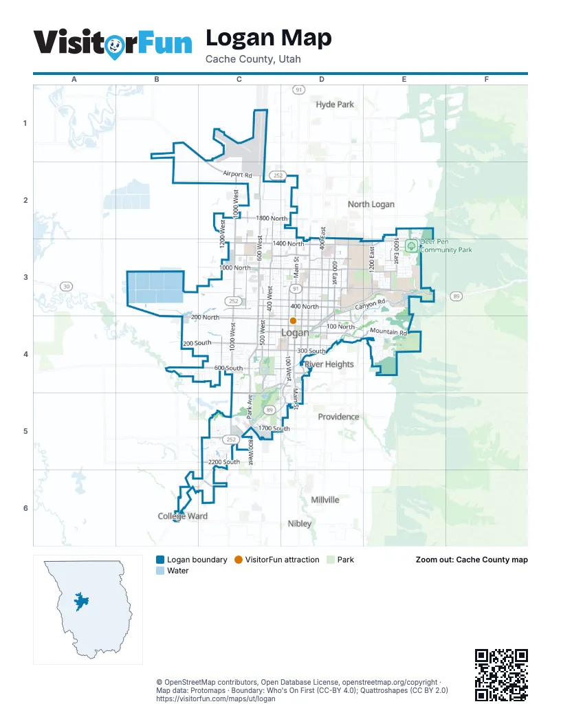
Street index of Logan
Each street on the sheet and the grid squares it crosses.
- 1000 WestC2, C3, C4, C5
- Main StreetD2, D3, D4, D5
- 200 NorthB4, C4, D4
- 400 NorthC3, D3, E3
- Airport RoadB1, C1, C2, D2
- Logan Canyon Scenic BywayE3
- 600 WestC2, C3, C4
- 1400 NorthC3, D3, E3
- 100 WestD3, D4, D5
- 200 EastD3, D4
- Canyon RoadD3, E3, D4
- 100 NorthC4, D4, D5
- 500 NorthC3, D3
- 600 EastD3, D4
- Center StreetC4, D4
- 700 NorthC3, D3, E3
- 100 EastD3, D4
- 600 SouthC4, D4
- 1200 EastE3
- Lars Hansen DriveD3
- 700 EastD3
- 1200 SouthD5
- Gateway DriveD4
- Mendon RoadB4
- 3200 SouthB6
- 1000 NorthC3, D3, E3
- 400 WestC2, C3, C4
- 200 SouthB4, C4, D4
- 400 EastD3, D4
- 500 WestC2, C3, C4
- 1200 NorthC3, D3, E3
- 800 WestC2, C3, C5
- 500 EastD3, D4
- Park AvenueC4, C5
- 1200 WestC2, C4, C5, C6
- Mountain RoadD4, E4
- 300 SouthC4, D4
- 1800 NorthC2, D2
- 1800 SouthC5
- 1900 WestB4
- 1600 EastE2, E3
- 1700 SouthC5
- Golf Course RoadC4, D4, C5
- 1500 NorthE2, E3
- BoulevardD3, D4
- 1500 EastE3
- 700 SouthC4, D4
- Aggie BoulevardD3, E3
- 1000 SouthC5
- 2200 SouthC5
- 2600 SouthB6, C6
- Cache Valley BoulevardD3
- Legrand StreetC5, D5
- Hyclone RoadC5
- Riverside DriveD4
- 2000 WestB6
- Crockett AvenueD3, D4
- Ellendale AvenueE3
- 1000 EastD4
- Country RoadD4
- Kip Thorne BoulevardD4
- 1130 WestC6
- 200 WestD2, D3, D4
- 600 NorthB3, C3, D3
- 300 WestC2, C3, C4
- 100 SouthC4, D4, E4
- 800 NorthC3, D3, E3
- 300 NorthC3, D3, E3
- 900 NorthC3, D3, E3
- 300 EastD3, D4
- 400 SouthC4, D4
- Sumac DriveE3, D4, E4
- 1100 NorthC3, D3, E3
- 1140 NorthC3, D3, E3
- Aspen DriveE2, E3
- 500 SouthC4, D4
- Canal RoadD3, E3
- Quail WayE3, E4
- 1400 EastE3
- 1600 NorthC2, D2, E2
- Legend DriveC4
- Gibbons ParkwayE4
- Three Point AvenueC4
- Eastridge DriveE4
- 1100 WestC5
- Winding WayE4
- 725 NorthC3, D3
- 1250 EastE3, E4
- 1250 WestC4, C5
- Meadowbrook DriveC4, C5
- Lauralin DriveD3, D4
- 800 SouthB4, C4
- Thrushwood DriveD4, E4
- 1300 EastE3, E4
- 1330 NorthC3, D3
- 1220 NorthE3
- 50 WestD3
- Mount Logan DriveE4
- 1700 NorthC2, E2
- 1280 WestC4, C5
- 150 WestD3
- 1150 NorthD3
- 1600 WestC5, C6
- 1600 SouthC5
- 1900 SouthC5
- Champ DriveD3
- 350 SouthC4, D4
- Stadium DriveD3, E3
- 1400 WestC4, C5
- Airport DriveC1, C2
- Fox Farm RoadE3, D4, E4
- Hillcrest AvenueE3
- Talon DriveC5
- Meadow CircleC4
- Red Fox TraceE4
- Cliffside DriveE4
- 1350 NorthC3, E3
- 1260 NorthD3, E3
- Harris Ball Park RoadE4
- 550 NorthC3
- Southwest StreetC4
- Talmage LaneE3
- Preston AvenueD3, D4
- Mallard LoopC4
- Bristol RoadE2, E3
- Scale House RoadB4, C4
- 1330 WestC5
- Shadow Mountain DriveE4
- Country Club DriveE3
- Black Hawk DriveC5, D5
- Thomas CourtC4
- 1380 WestC5
- 1530 NorthC2
- 470 NorthC3
- Cedar Heights DriveE3
- 350 WestC3, C4
- 1580 WestB4
- 1170 EastE3, E4
- Sunstone CircleC4
- Rosewood CircleC4
- Riverwalk DriveC4, D4
- 1300 NorthD3, E3
- Bike BoulevardD3, E3
- Trail CircleB4
- 775 NorthC3, D3
- 1110 NorthC3
- Riverwalk ParkwayD4
- University DriveE3
- Foothill DriveE2, E3
- 1700 EastE3
- Emme WayC5
- Center AvenueC4
- 1950 NorthD2
- Island DriveE3
- Johnson LaneD4
- 1080 NorthE3
- 1640 EastE2, E3
- 480 WestC3
- Penny LaneC2, D2
- 370 SouthC4
- 1550 NorthC2, D2, E2
- 1425 NorthE3
- 850 NorthD3, E3
- Country Manor DriveC5
- Maple DriveE3
- Lynnwood AvenueE3
- Teal LoopC4
- 330 SouthC4
- W 2260 SC5
- 290 SouthC4
- 870 NorthC3, D3
- Canterbury DriveD4
- 1720 EastE2, E3
- 880 NorthC3
- 130 SouthC4
- Creekside DriveC5
- Oak PlaceC4
- 375 WestC3
- Orchard Heights DriveE4
- 1250 NorthD3, E3
- 1800 EastE3
- Majestic DriveC4
- Oakwood DriveC4
- Jack B Parson DriveE3
- Eastridge LaneE4
- Suncrest LaneC2
- 1525 EastE2, E3
- 350 EastD3, D4
- Lavender LoopC2
- Crescent DriveD3
- 1820 SouthC5
- Quail Hollow RoadE4
- 250 WestD2, C3, D3
- Aggie Village DriveE3
- 950 WestC3, C4
- 850 WestC3, C4
- 1280 NorthD3, E3
- Kings CourtC3
- 1150 WestC3, C5
- 250 EastD3
- 660 SouthB4, C4
- 3000 SouthB6
- 1750 SouthC5
- 275 NorthD3, D4
- 630 WestC3
- 2000 SouthC5
- Fairway LaneC4
- Saddlehill DriveE3
- 1960 SouthC5
- Knowles LaneC4
- Sunset DriveE3
- 230 WestD2, D3
- 1050 NorthC3, D3
- Juniper DriveE3
- Western Park RoadC4
- 1780 SouthC5
- Ptarmigan LoopE4
- River Pointe DriveD4
- Riverwoods ParkwayD4
- 1500 SouthC5
- Bridger DriveC3, D3
- Canterbury LaneD4
- 1420 EastE3
- 2200 NorthD2
- 240 SouthC4
- 1275 EastE3
- Mountain Man WayC2, C3
- West Haven DriveC3
- 1350 EastE3, E4
- Mount Logan LoopE4
- 1240 WestC5
- 1750 EastE3
- 1025 NorthD3
- Evergreen DriveE3
- 690 SouthB4, C4
- 1075 NorthD3
- 1120 WestC5
- Ballard WayC5
- 360 WestC2, C3
- 850 SouthC4
- 530 SouthC4
- Riverbend RoadC4, D4
- HollyHock LaneD4
- 1185 NorthE3
- 1450 WestC5
- Pheasant Creek DriveC4, C5
- Rodeo LaneC4
- 1460 NorthE3
- Federal AvenueD4
- 1060 WestC4
- 1455 NorthC2, E3
- Apple DriveD3, D4
- Church StreetD4
- 550 SouthC4, D4
- 810 NorthC3
- Marindale AvenueC4
- Rsi DriveC3
- Temple AvenueD4
- 980 WestC4
- Johnson Ridge LaneC5
- Poplar AvenueD4
- 1770 EastE2
- Eastridge CircleE4
- 1500 WestC4
- 1540 WestB4
- Willow DriveC4
- 250 NorthC3
- 900 EastD3
- Southpointe CourtE2
- 2165 SouthC5
- 1730 EastE3
- Sharptail CircleE2, E3
- 1470 WestC4
- 780 WestC3
- 290 WestC3
- Rose StreetE3
- Conifer PlaceD4
- Northpointe CourtE2
- River Park StreetD3, D4
- Wasatch DriveD3
- 710 WestC3
- 750 EastD3, D4
- Dee AvenueD3
- 700 WestC4
- 1320 NorthE3
- Darwin AvenueD3
- 670 WestC3
- 2400 NorthD2
- 340 WestC2
- Greenview LoopC2
- Quail Canyon DriveE4
- Bonneville AvenueD3
- Water StreetD4
- Meadow VillageC3
- 1470 NorthC3
- 450 WestC3, C4
- 465 NorthD4
- Douglas DriveD3
- Circle View DriveE3
- Meadowview CourtB4
Things to do on the Logan map
Places on the map
- Adams Elementary School
- Bridger Park
- Cache County Fairgrounds
- Cache County Sheriff's Complex
- Canyon Entrance Park
- Center Street Historical District
- Deer Pen Community Park
- Denzil Stewart Nature Park
- Don Reese Park
- Ellis Elementary School
- FedEx at Walgreens
- First Dam
- First District Court
- Hillcrest Neighborhood
- Hyrum Gibbons Mt. Logan Park
- Jim Bridger Elementary School
- Logan Aquatic Center
- Logan Cemetery
- Logan City Green Waste
- Logan City Landfill
- Logan City Offices
- Logan Golf and Country Club
- Logan High School
- Logan Open Space
- Logan Regional Hospital
- Logan River Academy
- Logan River Golf Course
- Logan Utah Temple
- Lundstrom Park
- Maverik Stadium
- Mount Logan Middle School
- Old Main Hill
- Practice Field
- Ralph Maughan Track
- Ray Hugie Hydro Park
- Rendezvous Park
- Riverside Pre-school
- Southwest Gateway Park
- Utah State University
- Willow Park Sports Complex
Next to Logan
- College Ward
- Hyde Park
- Millville
- Nibley
- North Logan
- Providence
- River Heights
© OpenStreetMap contributors, Open Database License, openstreetmap.org/copyright · Map data: Protomaps · Boundary: Who's On First (CC-BY 4.0); Quattroshapes (CC BY 2.0)