

Utah map
Saratoga Springs map
About 57,411 people live here (Census Bureau, 2024 estimate). The sheet's index lists 300 streets; Redwood Road, Pony Express Parkway and Mountain View Boulevard cross the most grid squares. Also on it: TalonsCove Golf Course, Canal trail and Saratoga Springs Emergency.
Open the map (PDF, US Letter)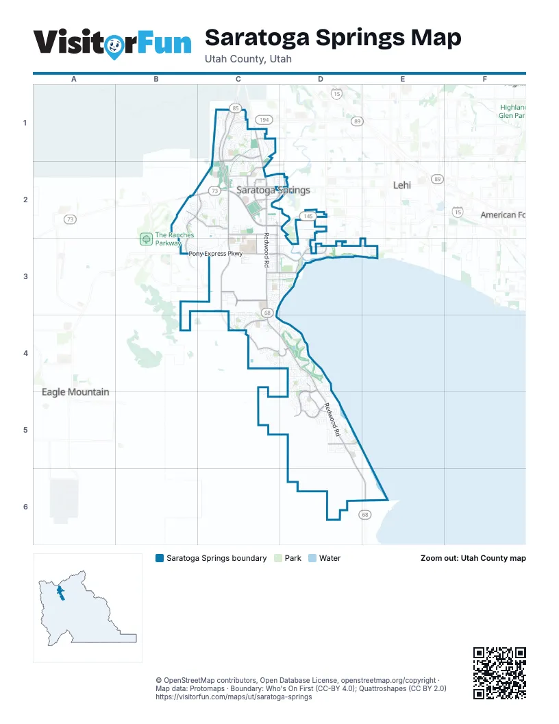
Street index of Saratoga Springs
Each street on the sheet and the grid squares it crosses.
- Redwood RoadC1, C2, C3, C4, D4, D5, D6, E6
- Pioneer CrossingC2, D2
- Mountain View CorridorC1, C2
- Pony Express ParkwayB3, C3, D3
- Cory B Wride Memorial HighwayB2, C2
- Mountain View BoulevardC2, C3, C4
- Saratoga RoadD2, D3
- Crossroads BoulevardC2, D2
- Grandview BoulevardC4
- Market StreetC2
- 2300 WestD2
- Founders BoulevardC3
- Village ParkwayD4, D5
- Harvest Hills BoulevardC1
- Riverside DriveC2, D2, C3
- Mount Saratoga BoulevardB2, C2, B3
- Wildlife BoulevardD5
- 400 NorthC2
- Talus Ridge DriveB2, C2
- Exchange DriveC2
- Aspen Hills BoulevardC2
- Swainson AvenueD5
- East Pony Express ParkwayD3, E3
- Ensign DriveC3
- 400 SouthC3, D3
- Medical DriveC2
- Ring RoadC4, D4
- Halvorsen ParkwayC3
- Lariat BoulevardC4
- Thunder BoulevardC2, C3
- Harbor ParkwayD5
- 1500 NorthC1, C2
- Harbor Park WayD5
- 400 WestC2
- Village Court RoadD4, D5
- 400 EastD2
- Lazaret AvenueD2
- Cold Spring DriveC2
- 1140 NorthC2
- Old Ranch RoadD2
- Silverlake ParkwayB3
- West 1900 SouthE3
- Centennial BoulevardC4, D4
- Providence DriveC1, C2
- Harvest Moon DriveC1, C2
- Parkway BoulevardC3, C4, D4
- Saratoga DriveC3, D3
- Salvia DriveC1
- Chianti StreetC1, C2
- Lake Mountain DriveD5
- Commerce DriveC2
- Stillwater DriveD4
- McGregor LaneD5
- Sunrise DriveD5
- Legacy ParkwayC3, D3
- Hillside DriveC3, C4
- School House RoadC3, D3
- Shorewood DriveD4
- Sagehill DriveC2
- Fairfield RoadC3
- Dandelion DriveC1
- Parkside DriveC3, C4
- Fairway BoulevardD4
- Stone Gate DriveB3, C3
- Colt DriveD4
- Spinnaker Bay DriveD5
- Lake Vista DriveD5
- Woodland RoadB2
- Panorama DriveD5
- Elderberry DriveC1, C2
- Fox Hollow DriveD4, D5
- Maverick RoadD4
- Highpass DriveC2
- Banner DriveB2
- Lake View Terrace RoadC3, C4
- Rolling Sage WayC4
- Boseman WayB2, C2
- Wild Hyacinth DriveC1
- Buffalo DriveC2
- Seaside StreetD3
- Stagecoach DriveC1
- Garibaldi WayD5
- Skyline DriveB2, C2
- Meadow Crest WayC3, C4
- Quailhill RoadB3, C3
- Palomino DriveD4
- Lake DriveC2
- Tytus LaneD5
- Wild Blossom BoulevardC1, C2
- Summerhill DriveD4
- Carlton AvenueC2, C3
- Highpoint DriveC3
- Range RoadD4
- Hawk DriveD5
- Alpine DriveC3, C4
- Marigold DriveC2
- Pinnacle LaneC2
- Starlight DriveD5
- Ruger DriveC4
- Marie WayC3
- Remington AvenueC4, D4
- Evans LaneC2
- Summit View DriveC2
- Honeysuckle DriveD4
- Casi WayD5
- Lukas LaneC4
- Polaris DriveC3, D3
- Old Farm RoadC3
- Fox Pointe DriveD4, D5
- Meridian DriveC2
- Big Horn DriveC1
- Hillcrest RoadC1
- Northshore DriveD2, D3
- Lori LaneD5
- Geranium DriveC1
- Goldenrod WayC1, C2
- Colonnade RoadC2, C3
- Red Wolf DriveD5
- Orchard WayC1
- Alta View DriveB2, C2
- Greenhead DriveD4, D5
- Valley View DriveC4
- West Rim DriveC1
- Bono BoulevardC2
- Cozy LaneC2
- East El Nautica Boat Club DriveD5
- Fall Harvest DriveC1
- Wild Yarrow DriveC1
- Hollow WayD5
- Ivy LaneD4
- Cove RoadC3
- Beacon DriveD5
- Regal View DriveC3, C4
- Snowberry DriveC1
- Church DriveC3
- Deer Meadow DriveD5
- Schooner DriveD5
- Russo DriveB2, C2
- Willow Creek DriveD5
- Andrews LaneC2
- Day Lilly DriveD4, D5
- Vineyard WayC1, C2
- 1000 WestC2, C3
- Peregrine TrailD5
- Wasatch DriveC2
- Sandpiper LaneD5
- Crooked Post WayC3, D3
- Landview DriveC4
- Deer Canyon DriveD5
- Wrangler AvenueD4
- Yellow Bill DriveD4, D5
- NorthgateC2
- Inlet Spring DriveC3, D3
- Wildflower DriveD4
- Nectar WayC1
- Rocky Ridge LaneC3, C4
- Mountain Peak DriveC2
- Sage Bloom WayC4
- East Lakeview DriveE3
- Blue Dawn LaneC1
- Meadow Side DriveC3
- Wiltshire LaneD4
- East Hawthorn StreetE3
- Jubilee DriveC3
- Stetson AvenueC4
- High Rock AvenueC3
- Bliss DriveD4
- Alhambra DriveC2, D2
- Waterside DriveC3
- Utah Cottage DriveC2
- Jack Rabbit RunC2
- North Lake Mountain Comm RoadC5
- Caroline DriveC3
- Hill View DriveB2
- Empire Spring DriveC3, D3
- Pilot StreetD3
- Wildcat LaneD4
- Cimarron AvenueC4, D4
- Western DriveC4, D4
- Pondside DriveC3, C4
- Bennedict DriveB2
- Halls Creek RoadC3, D3
- Lexington WayC3
- Regent StreetC2
- Independence WayC3
- Boston StreetC1
- Greyhound RoadD5
- Cottage CoveD4
- Lighthouse DriveC3
- Coyote RunC2
- Blue Mountain DriveC3
- Sara DriveC3
- Herald DriveC3
- Autumn Creek DriveD5
- Bertha DriveC3
- Woodrun WayC3
- 1200 NorthC2
- Joshua Tree StreetC3
- Heartstone LaneC3, D3
- Hickory StreetD5
- Puddle LaneD4, D5
- West Military RoadC2
- Kestrel DriveD5
- Bountiful WayC1, C2
- Kanab Creek DriveC3, D3
- Weatherby DriveC4
- Kings Canyon BoulevardC3
- Echo WayC2
- Venetian WayC2
- Forest AvenueD5
- Ridge RoadC1, C2
- Cooper AvenueD5
- Bluebell DriveC1
- Waterview DriveD4
- Wayside DriveD5
- 1470 NorthC1
- Blue Heron DriveD5
- Olympus DriveB2
- Red Fox LaneC2
- Eaglewood DriveB3
- Grand Sierra WayC2
- Wander AvenueC3
- Appellation DriveC2
- Pumpkin Patch DriveC1
- Preening WayD4, D5
- Commodore LaneD2
- Starhaven DriveC2
- Hunter DriveD4
- Red Tailed CrescentD5
- Mountain Moon DriveD5
- Muskmelon WayC1
- Captains StreetD5
- Teal RoadC3
- Kenai Fjords StreetC3
- Pheasant LaneC2
- Candlelight DriveC3
- 1400 NorthC2
- Harvest Village LaneC1
- Mountain Ridge DriveC4
- Wagoneer RoadC3, C4
- Kern AvenueC2
- Winter Wheat WayC1
- Blue Water LaneD4
- Catamaran WayD5
- Baltic Rush AvenueD4
- Freeman DriveC2
- Moorhen DriveD5
- Red Pine DriveD5
- Montego DriveD5
- Red Velvet LaneC1
- High Ridge RoadB2
- Cahill AvenueC4
- Heron Hills AvenueD5
- Mckenzie WayC2
- Country RoadC2
- Badger LaneC2
- Broadway DriveC2, C3
- Shadow Ridge DriveD4
- Sage LaneC2
- Beretta DriveC4
- Apple AvenueC1
- August DriveC2
- Stroll AvenueC3
- Misty Sage WayC4
- Scuttlebutt LaneD2
- Lewis LaneC2
- Arcadia DriveC2
- Jordan Ridge BoulevardC2
- Loveland LaneC3, C4
- Jamaica WayD5
- Snowy Egret AvenueD5
- Valcrest DriveB3
- Green River RoadD3
- Peony DriveC2
- Sage DriveC1
- Barton DriveB2
- Peachtree LaneC3
- Cottonwood LaneC4, D4
- Thrive DriveC2, D2
- 4100 WestC1
- Thistle DriveC1
- Devonshire DriveC2
- Birch DriveD4
- Joshua DriveC2
- Olivia LaneD4
- Morgan RoadD4
- Kit Fox DriveD4
- Cottontail LoopD4
- Floribunda DriveC2
- Violetta DriveC1
- Bearing DriveD2
- Cameron DriveD4
- Pelican LaneD5, E5
- Western Hills DriveC2
- Harrier DriveD5
- Granary WayC1
- Aruba DriveD5
- Danverse DriveB2
- Mustang LaneC2
- Ruddy WayD5
Places on the map
- ABC Great Beginnings - Saratoga
- Affinity Autism Services
- Air Force Field
- Alpine School Distict Bus Depot
- America First Credit Union
- Arctic Circle
- Army Field
- Canal trail
- El Nautica Boat Club
- Fitness Trail Park
- Fox Hollow Park
- Golden Hills Park
- Grasslands Park
- Harbor Point Elementary School
- Harvest Hills Nature Park
- Harvest Park
- Inlet Park
- Lakeview Academy
- Landrock
- Legacy Parkway
- Marina Park
- Meridian Park
- Neptune Park
- Orchard Park
- Patriot Park
- Peppermint Trail Park
- Pinnacle Park
- Saratoga Ridge Park
- Saratoga Springs Emergency
- Saratoga Springs Library
- Shay Park
- Shoreline Park
- Sunrise Bike Park
- TalonsCove Golf Course
- The UPS Store
- Vista Heights Junior High
- Walmart Supercenter
- wander
- Westlake Emergency Center
- Westlake High School
Next to Saratoga Springs
© OpenStreetMap contributors, Open Database License, openstreetmap.org/copyright · Map data: Protomaps · Boundary: Who's On First (CC-BY 4.0); Quattroshapes (CC BY 2.0)















