

Utah map
Spanish Fork map
About 47,809 people live here (Census Bureau, 2024 estimate). The sheet's index lists 300 streets; Mike Dmitrich Highway, Veterans Memorial Highway and North Main Street cross the most grid squares. Also on it: Spanish Fork Sports Park, Spanish Oaks Golf Course and Maple Mountain High School.
Open the map (PDF, US Letter)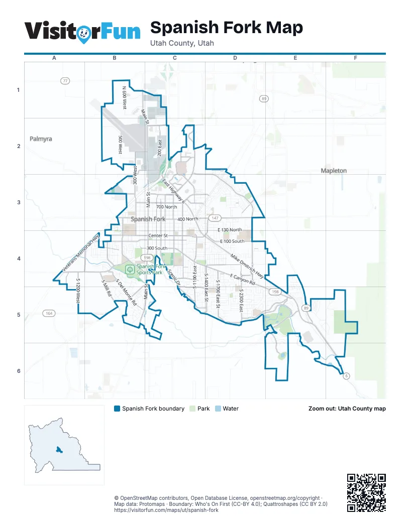
Street index of Spanish Fork
Each street on the sheet and the grid squares it crosses.
- Veterans Memorial HighwayC2, B3, C3, A4, B4
- Mike Dmitrich HighwayC3, C4, D4, E4, E5, F6
- North Main StreetB1, C1, C2, C3, C4
- South Main StreetC4, B5, C5
- East Highway 6C3
- Highway 89E4, E5
- West Arrowhead TrailB5
- Arrowhead TrailB4, C4, B5
- East US-6C3
- 400 NorthB3, C3, D3
- East Canyon RoadC4, D4, D5, E5
- Dry Creek ParkwayC2
- South Spanish Fork ParkwayD4
- 300 SouthB4, C4, D4
- Canyon Creek ParkwayC2
- Center StreetB4, C4
- North Canyon Creek ParkwayC2, C3
- East Powerhouse RoadE5
- East Center StreetC4, D4
- East 1000 NorthC3
- Spanish Fork ParkwayD3, D4
- 1000 NorthB3, C3
- East 1000 North StreetC3
- 6400 SouthD3
- Center Street (Frontage)C4
- South Woodland Hills DriveB5
- State RoadD2
- 200 EastC2, C3, C4
- 100 SouthB4, C4
- North Marketplace DriveC2, C3
- Scenic DriveC4, C5
- 300 EastC3, C4
- 300 WestB2, B3, B5
- South 1700 East StreetD4, D5
- East Canyon Crest DriveD5, E5
- South Del Monte RoadB4, B5
- East 100 SouthD4
- East River Bottom RoadD5, E5
- 800 NorthB3, C3
- South 1400 East StreetD4, D5
- 600 EastC3, C4
- 400 EastC3, C4
- South Mill RoadB4, B5
- South 2300 EastD4, D5
- East 750 South StreetC4, D4
- North Spanish Fork ParkwayD3
- East 1240 South StreetC5, D5
- 1600 NorthB2, C2, D2
- South 1200 WestA4
- East Expressway LaneC3, D3
- North 300 West StreetB3, B4
- Volunteer DriveB4, C4
- South 1100 EastC4, C5
- East Spanish Fork ParkwayC2, D2, D3
- East 800 NorthC3, D3
- West Center StreetB4
- Spanish Oaks DriveE5, E6
- Spanish Fields DriveB4
- South West Park DriveB4
- West 900 South StreetA4, B4
- 2000 WestC1, A4
- North 800 East StreetC3, C4
- South 820 EastC4
- 900 SouthA4
- East 1050 SouthC4
- South 1150 EastC4
- East 2200 South StreetD5
- West 1100 SouthB4
- 1550 WestB4
- Industrial Park DriveC2, C3
- 2300 EastD4
- South 600 East StreetC4
- 630 WestB3, B4
- 800 EastC4
- North Slant RoadD3
- 1430 EastD3, D4
- South 1100 East StreetC5
- East Commerce WayC3
- 920 SouthD4
- East Marketplace DriveC2
- South 1550 West StreetA4, B4
- South 630 West StreetB4
- 2050 NorthB2, C2
- North Commerce WayC2, C3
- North Chappel DriveC2
- South 3400 EastE5
- East 1750 South StreetC5, D5
- East Deer Trail DriveC4
- East Kirby LaneC3
- North 600 EastC3
- North 400 East StreetC3
- Bottoms RoadC5, D5
- West 100 South StreetB4
- East 1950 NorthC2
- South 200 East StreetC4
- North 800 EastC3
- North 630 WestB4
- South River Bottoms RoadC4
- 1150 EastC4
- North 350 EastC1
- South Scenic DriveC4
- East 800 North StreetC3
- 200 NorthB3, C3
- Cemetery RoadsC4
- 300 NorthB3, C3
- 500 NorthB3, C3
- 600 NorthB3, C3, D3
- Harmony Ridge ParkwayE5, F5
- 100 EastC3, C4
- 100 NorthB4, C4
- 500 EastC3, C4
- 100 WestB2, B3, B4
- 200 SouthB4, C4
- East 130 NorthD3
- 700 NorthB3, C3
- 500 WestB2, B3
- 200 WestB3, B4, B5
- South River Ridge LaneB4, B5
- 900 NorthB3, C3
- East 600 SouthC4, D4
- East 1400 South StreetC5, D5
- North 600 WestB1
- 700 EastC3, C4
- 400 SouthB4, C4
- South Windy Ridge DriveE4, E5
- East 320 NorthD3
- East 410 SouthC4, D4
- Fairway DriveE5, E6
- East 500 South StreetC4, D4
- South 2000 EastD4, D5
- East Williams LaneC2
- North 700 EastC3
- East 1850 South StreetD5
- East Rio Grande DriveD4
- East 260 NorthC3, D3
- 3250 NorthB1
- South 2900 East StreetE5
- South 800 West StreetB4
- Spanish Trails BoulevardB4
- 2040 EastD3
- East 1330 South StreetC5, D5
- East 900 SouthC4
- South 1800 EastD4
- Calpac AvenueB5
- East 200 NorthC3, D3
- 900 EastC3, C4
- East 1630 South StreetC5, D5
- South 900 East StreetC4
- Limber Pine DriveF5
- South 3750 EastE4, E5
- High Line Canal RoadE5
- 3450 NorthB1
- East 970 NorthD3
- West 3000 NorthB1
- Tamarack DriveE5, F5
- 450 SouthB4
- South 1400 EastC4
- South 1560 EastD4, D5
- North Coachman LaneD3
- East 1000 SouthC4
- East Somerset DriveD4, E4, E5
- North Freight Wagon LaneD3
- West 300 South StreetB4
- Dolostone StreetB5
- East Ridgefield RoadD3
- 1130 SouthD4
- 1400 NorthB3, C3, D3
- East 700 SouthD4, E4
- North White Horse DriveC3, D3
- North 1980 EastD3
- Silverado LaneD3
- South 1650 EastD4
- North Mitchell DriveB3
- South 1700 EastD4
- South 1230 West StreetB4
- South 880 West StreetB4
- East 900 NorthD3
- Heartwood RoadE5
- East 1650 SouthD5
- East 1900 South StreetD5
- South 950 West StreetB4
- East 7200 South StreetE4
- South Barley DriveB4, B5
- Acacia DriveF5
- 1120 SouthB4, D4, E4
- South 900 EastC4
- Mountain View DriveD4
- West River Ridge LaneB4
- Atwood RoadA4
- North Rees AvenueD3
- East 150 SouthC4, D4
- Granite StreetB5
- East 1480 South StreetC5, E5
- East 1180 SouthD4, E4
- Summit DriveB5, C5
- West Academy DriveB4, B5
- 1900 NorthB2
- 360 SouthD4, E4
- North Spring LaneD3
- 1000 SouthD4, E4
- South 2410 EastD5
- North 1800 EastD3, D4
- North Legacy Park DriveD3
- South 2600 East StreetD5
- 1050 SouthD4
- East 1600 South StreetD5
- East 300 SouthC4, D4
- East 1530 SouthE5
- East 1270 SouthE5
- East 280 SouthD4
- South 2000 East StreetD5
- 1270 EastC3, C4
- East 390 NorthD3
- Hawk DriveE5, E6
- North 1120 EastC3
- South 1860 East StreetD5
- North Wagon WayD3
- Depot RoadB3
- East 1530 South StreetD5
- South 100 West StreetB4
- East 1520 SouthD5, E5
- Obsidian StreetB5
- North Ponderosa LaneD3
- South 750 West StreetB4
- South Oak Ridge DriveE5, E6
- East 1710 South StreetC5, D5
- North Stallion DriveD3
- South Sandbar WayB4
- Alder DriveE5
- 2700 NorthB2
- East 1610 South StreetE5
- South 1240 EastC4
- South 2600 EastD4, D5
- East Somerset Village WayE4, E5
- 350 WestB5
- South 1170 East StreetC4, C5
- South Wolf Hollow DriveC4
- East 1360 SouthE5
- Old Fort DriveD3
- South 550 West StreetB4
- Olive AvenueE5
- South River View DriveB4, B5
- 920 NorthC3, D3
- North Golden Spoke DriveD3
- South Spanish Ridge RoadD5
- Dover DriveD4
- 1600 WestA4
- East 1250 SouthD5, E5
- East Heritage DriveD3
- North 1590 EastD3, D4
- South 1960 East StreetD5
- Meadow LaneD2, D3
- North 2350 EastD3
- South 1760 East StreetD5
- South Vincent Ridge DriveD5
- East 1035 South StreetD4
- East 300 South StreetC4
- East 950 South StreetC4, D4
- South Maple Leaf DriveD4
- 240 WestB5
- East Stony Hill WayD5
- Red Stone StreetB5
- South 1600 EastD4
- East 1200 SouthD4
- South 1400 West StreetB4
- South 1450 EastD4
- South 1500 EastD4
- South 1550 EastD4
- South Stony View DriveD5, E5
- South 1850 EastD4
- North Loop RoadB1
- South 690 EastC4
- East Flonette AvenueC4
- South 2370 East StreetD5
- West 450 South StreetB4
- East 1700 SouthD5
- East 700 NorthD3
- East 800 SouthC4, D4
- North 1280 EastC3
- East Haywain DriveD3
- 1510 SouthD5
- South 1510 East StreetD4
- West 480 North StreetB3
- East 1580 SouthD5
- East 3450 NorthB1, C1
- Eagle DriveE5, E6
- East 850 SouthC4, D4
- West 1550 South StreetB5
- South Fox Hill DriveC4
- South High Ridge DriveD4
- South 2250 EastD4, D5
- West 920 South StreetB4
- 1880 EastD3
- Cedar LaneE5
- North 920 West StreetB3, B4
- Sterling DriveC4
- East Fairway LaneE5
- East 1900 SouthD5
- 1170 WestB4
- 850 NorthD3
Places on the map
- Abbey Court Park
- Adventure Heights
- America First Credit Union
- American Leadership Academy
- Angelus Theatre
- Arby's
- AutoZone
- Bank of America
- Barry's Parkview Drive Inn
- Boothe Brothers Performing Arts Center
- Brockbank Elementary School
- Burger King
- CAL Ranch
- Canyon Elementary
- Canyon View Community Garden
- Canyon View Park
- Canyon View RV Park
- Centennial Park
- East Meadows Elemetary School
- FedEx Office
- Intermountain Health Spanish Fork
- Legacy Farms Park
- Legacy Park
- Maple Mountain High School
- North Park
- Riverview Elementary School
- Sierra Bonita Elementry
- Spanish Fork City Cemetery
- Spanish Fork Fairground
- Spanish Fork Gun Club
- Spanish Fork High School
- Spanish Fork Junior High
- Spanish Fork Readiness Center
- Spanish Fork Sports Park
- Spanish Oaks Elemetary
- Spanish Oaks Golf Course
- Spanish Oaks Loop Trail
- Spanish Oaks Reservoir
- Utah County Jail
- Walmart Supercenter
Next to Spanish Fork
- Mapleton map
- Palmyra
© OpenStreetMap contributors, Open Database License, openstreetmap.org/copyright · Map data: Protomaps · Boundary: Who's On First (CC-BY 4.0); Quattroshapes (CC BY 2.0)















