

Virginia map
Page County map
About 23,686 people live here (Census Bureau, 2024 estimate). The sheet's index lists 300 streets; Skyline Drive, South Page Valley Road and Pine Grove Road cross the most grid squares. Things to do inside the boundary: Luray Caverns and Shenandoah National Park.
Open the map (PDF, US Letter)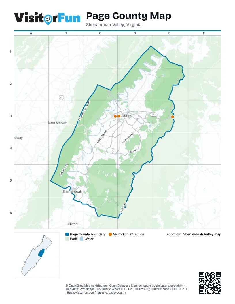
Street index of Page County
Each street on the sheet and the grid squares it crosses.
- US Highway 211D3, E3
- East Main StreetD3, C4, D4
- West Main StreetD3, C4
- 3rd StreetD3, B5
- Virginia AvenueD3, B5
- 4th StreetD3, B5
- North Broad StreetD3
- North 5th StreetB5
- South Third StreetB5
- South Broad StreetD3
- Stonewall Jackson HighwayE1
- South 3rd StreetB5
- East Lee HighwayB3
- Skyline DriveE2, E3, D4, E4, D5, D6
- Leaksville RoadC3, D3, C4
- Maryland AvenueB5
- Thornton Gap EntranceE3
- Northcott DriveD3
- East Point RoadB5
- Jollett RoadC6, D6
- Ida RoadD3, D4
- Mill Creek RoadC3, D3, C4
- Grove Hill River RoadC4, B5, C5
- Airport RoadC3, D3
- Rileyville RoadD2, E2
- Mill Creek CrossroadsC4, D4
- River RoadD2, C3, C4
- Bixlers Ferry RoadC2, C3, D3
- Dry Run RoadD3, E3
- Stonyman RoadD3
- Fleeburg RoadB5, C5, B6
- Fort Valley RoadC2
- Loop RoadC6
- Comertown RoadB5, C5
- Big Oak RoadC3
- Brookstone RoadD3
- North Egypt Bend RoadC2, C3
- Aylor Grubbs AvenueC4
- Clearview RoadD3
- Fairview RoadD3
- Marksville RoadD4
- Miller Creek RoadC4
- Camp Roosevelt RoadC2
- South Antioch RoadD3
- 1st StreetD3, B5
- Boston RoadC4
- Forrest DriveC4
- Cave Hill RoadC3, D3, C4
- Eden RoadD3
- Reservoir AvenueD3
- South Court StreetD3
- State Route 667D3
- Comer Town RoadC5
- Junior AvenueB5
- Grove Hill RoadC4
- Mechanic StreetD3
- Lakewood DriveD3
- Pond AvenueC4
- Collins AvenueD3
- Wallace RoadD3
- State Route 731D3
- North Hawksbill StreetD3
- Creekside DriveD3
- Chapel RoadC4, D4
- General DriveC3
- Antioch RoadD3
- State Route 602B5
- Comer LaneB5
- Collins StreetD3
- Naked Creek RoadC6
- Crisman Hollow RoadC2, B3, C3
- South Page Valley RoadC2, D2, C3, D3
- Page Valley RoadD1, E1, D2
- Farmview RoadD3, D4
- Cub Run RoadB4, B5
- Vaughn Summit RoadD2
- Egypt Bend RoadC3
- Dovel Hollow RoadC4, C5
- Rocky Branch RoadD3, E3
- Tanners Ridge RoadC5, D5
- Newport RoadB4
- Lucas Hollow RoadC4, C5
- Honeyville RoadC4
- Strole Farm RoadB4, B5
- Pine Grove RoadC4, D4, C5, D5
- Kimball RoadD3
- Dam Acres RoadC4
- Weaver RoadC5, C6
- Valley Burg RoadD3, D4
- State Route 669D3, E3
- Forest DriveC3, C4
- Hollow Run RoadD4
- Judy LaneC4
- Piney Hill RoadC4
- Balkamore Hill RoadD4
- Island Ford RoadD1, E1, D2, E2
- Old Stanley RoadC4
- Gander's DriveC3, C4
- Kauffmans Mill RoadC3
- Shuler LaneC4
- Keystone RoadC4, C5
- Riverside DriveC3, C4
- Redman Store RoadD3, D4
- Fort Stover RoadD2
- Kite Hollow RoadD4
- Old Wagon RoadD4
- Cavalier RoadD2
- Cross Mountain RoadD4
- Old Forge RoadD2, D3
- Basin Hollow RoadC5
- Park Line RoadD5
- Beahm LaneD2, E2
- River View DriveC3, C5
- Mt Carmel RoadC3, D3
- Elgin DriveD2, D3
- Shipwreck RoadB5
- Somers RoadD3, D4
- Mike Long's Woods RoadC4
- Old Farm RoadD3, B5, C5
- Cubbage Hollow RoadC5
- Oak Leaf DriveC3
- Sunnyview DriveD2
- Pass Run RoadD2, D3
- Hamburg RoadC3
- Riverwater RoadD2
- Canoe River DriveD1, D2
- Crooked Run RoadB5, C5
- Phoebe LaneC4
- Goodrich RoadC4, D4
- Battle Creek RoadC4
- State Route 624C4, D4, C5, D5
- Hulse RoadD2
- Harper Valley RoadD4
- Homestead DriveC3
- Mt Zion RoadD3
- State Route 654D3
- Longs RoadC3
- Serenity Ridge RoadC2
- Riverbend RoadC4
- South Creek RoadC6
- Kibler Hill RoadD2
- Alshire Hollow DriveD4, D5
- State Route 662E1, E2
- Overlook Mountain RoadC6
- State Route 666E3
- Overlook DriveE2, C3
- Jewell Hollow RoadE3
- Shipyard RoadB5
- Valley View LaneE2, B4
- Round Head Mountain RoadC4
- Ridge View LaneB5
- Grindstone Mountain RoadC5
- Shenk Hollow RoadE3
- Piney Woods RoadC4
- Fleeburg LoopB5, C5, B6, C6
- Mims RoadD2
- Lazy River West RoadD2
- River Valley RoadD2
- Valleyburg RoadD3
- Log Cabin DriveD4
- Mountain Top Ranch RoadC5, C6
- 2nd StreetD3, B5
- South Fork River LaneB5
- Hook Hill RoadD2
- 6th StreetD3, B5
- Spring Cliff RoadD4
- River View RoadD1, D2
- Printz Mill RoadD3, D4
- Ida Hollow RoadD4
- Backwash RoadC3
- Old Farms RoadD3
- Hawksbill Park RoadD4
- Wildwood LaneC5
- Jordan Hollow RoadD4, D5
- Sedwick RoadD3
- Almond DriveD2
- Waterside DriveB4, C4
- Whispering Hill RoadD3
- Paul LaneB5
- River Lodge RoadD2
- Riverdale Farm RoadC4
- Sandy Hook RoadD2, D3
- Frank Ballard RoadC4
- Parkview Est RoadD3
- Valley View RoadE2, D4
- Ridge RoadD2, C3, C4
- Cold Springs DriveC5
- Carvell RoadE1
- Wagon Trail LaneB4
- Batman RoadB5
- Brady RoadC4, D4
- Richview RoadD2
- Shenandoah River RoadB5
- Big MeadowsD5
- Edgewood DriveD3, D4, B5
- Sunny LaneC6
- Skyland Lower LoopD4, E4
- Back RoadB5, C5
- Springfield RoadD2, D3
- 5th StreetD3, B5
- Mill Run RoadB5
- Long AvenueB5
- Cub Run Farm LaneB4, B5
- Friendly LaneD5
- Hill Climb RoadB4, C4
- Matthews Arm RoadE2
- Falling Leaf RoadD4
- Walnut Hill RoadD4
- Power Dam RoadC3
- Kite's CornerB5
- Quincy AvenueB5
- Cross Creek RoadC3
- Hinton RoadD3
- Mosby Camp RoadD4
- Good Mill RoadD2
- Mountain Run RoadC3
- Panther DriveB4
- Overall RoadE1
- Precision RoadB5
- Cliff Heights RoadD5
- River Hills RoadC5
- T C Northcott BoulevardC3
- Compton Hollow RoadE1, E2
- Steam Hollow RoadC5
- Kibler DriveC3
- Sunnyside RoadB4
- East Branch RoadD3
- Ruffners Ferry RoadC3, D3
- South Lake View DriveD5
- Lazy River East RoadD2
- Alger DriveE1
- Eldon Yates DriveC4
- Middleburg RoadC4, D4
- Atkins DriveD3
- Spring View BoulevardD3
- Morning Star RoadE3
- Lam's CrossingB6, C6
- Lorelei LaneD2
- Cathy's Mountain DriveC2, C3
- Riverbend DriveC3
- Spir RoadC5
- Circle View RoadD3
- Jeremiah's Run RoadD2, E2
- Ferrell LaneC5, C6
- Dry Creek RoadD3, D4
- Memorial DriveD3, C4
- Outpost RoadD2
- High Pines RoadC3
- Skyland Upper LoopD4, E4
- Longview RoadC3
- Denver AvenueB5
- Massanutten AvenueD3, B5
- Kemble Spring LaneC5, C6
- West Juniper LaneC4, D4
- Lost Corner RoadE1
- Steam LaneC5
- Church AvenueC4
- Oak Forest LaneC3
- Ida Loop RoadD4
- Peach Orchard RoadD4
- Cedar LaneC3, D3
- Woodside DriveD2
- White Oak RoadC3
- Cardinal DriveC3
- Creek End LaneC6
- Leola LoopC4
- Shenandoah DriveC3
- Luray AvenueD3
- Ridge LoopC2
- Rosedale LaneD3, D4
- Cattail LaneC2, C6
- Helms RoadD4
- Panorama View DriveB4, C4
- Grace Church LaneD4
- Pennsylvania AvenueB5
- Shenk LaneC2
- Cobblestone LaneC4, C5
- State Route 656D3
- Owen LaneD4
- Circle DriveC3, D5
- Fox Hollow RoadD4
- Shenandoah AvenueB5
- Fort Liscomb RoadD2
- Heather LaneD4
- Highview RoadD2
- Hawksbill DriveD4
- Valley DriveC4, D4
- Herdman Hill RoadD4
- Jacobs LaneC4
- Pollack RoadD4
- Sub Station RoadB5, C5
- State Route 611D2, D3
- Painters Woods RoadC4
- StricklerC3
- Pheasants RunD4
- Liberty Bell LaneD3
- Brenwood DriveD4
- McCoy LaneC4
- South McDaniel LaneB5
- Woodland DriveC3
Things to do on the Page County map
Places on the map
- Bailey Mountain
- Beahm's Chapel Cemetery
- Bealers Pond
- Betty's Rock
- Big Mountain
- Bird Knob
- Blackrock
- Breedlove Knob
- Broadus Mountain
- Bushytop
- Carillon Park
- Catback Mountain
- Cave Hill
- Caverns Country Club Resort
- Chapman Mountain
- Crescent Rock
- Farm
- Field
- Grass field
- Jellystone Park Luray
- Lake Arrowhead
- Lake Arrowhead Park
- Lewis Mountain Campground
- Luray
- Luray Caverns
- Luray Caverns Airport
- Luray High School
- Luray Reservoir
- Luray RV Resort on Shenandoah River
- Matthews Arm Campground
- Newport Reservoir
- Page County High School
- Ralph H. Dean Recreation Park
- River Run Campground
- Shenandoah
- Shenandoah Reservoir
- Stanley
- The Meadow
- Wodland
- Woodland
Next to Page County
- Broadway
- Elkton
- New Market
© OpenStreetMap contributors, Open Database License, openstreetmap.org/copyright · Map data: Protomaps · Boundary: Who's On First (CC-BY 4.0); Quattroshapes (CC BY 2.0)















