

Vermont map
Brattleboro map
About 11,975 people live here (Census Bureau, 2024 estimate). The sheet's index lists 300 streets; Marlboro Road, Putney Road and Vernon Street cross the most grid squares. Things to do inside the boundary: Vermont Maple Museum.
Open the map (PDF, US Letter)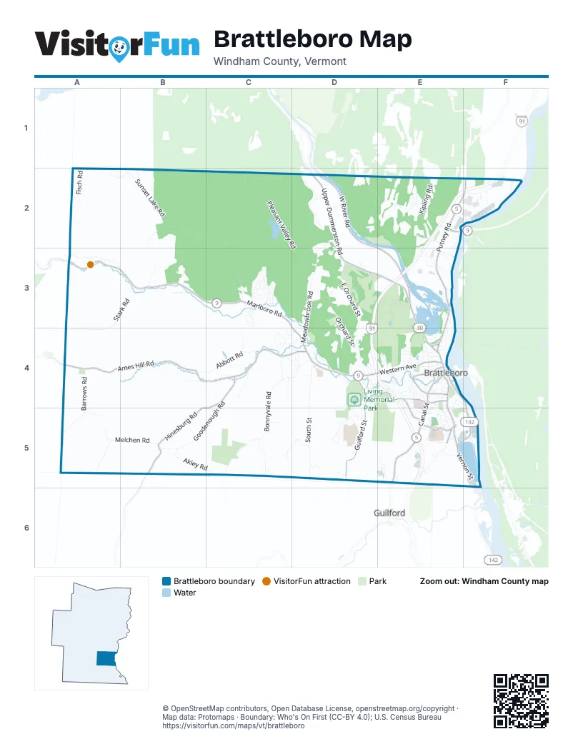
Street index of Brattleboro
Each street on the sheet and the grid squares it crosses.
- Marlboro RoadA3, B3, C3, D3, D4
- Putney RoadE2, F2, E3, E4
- West River RoadD2, E3
- Western AvenueD4, E4
- Canal StreetE4, E5
- Linden StreetE3, E4
- High StreetE4
- Main StreetE4
- Chesterfield RoadE2
- Park PlaceE4
- United States Navy Seabees BridgeE2
- Vermont Route 9A3
- Vernon StreetE4, F4, E5, F5
- Brattleboro RoadE4
- Bridge StreetE4
- Fort Bridgman RoadF5
- Ames Hill RoadA4, B4, C4
- Hinesburg RoadC4, B5, C5
- Upper Dummerston RoadD2, D3, E3
- Guilford StreetD4, D5
- South Main StreetE4, E5
- Maple StreetD4, E4
- Greenleaf StreetC4, D4
- Fairground RoadE5
- Elliot StreetE4
- Fairview StreetE4, E5
- Birge StreetE4
- Cotton Mill HillE5
- Pine StreetE4
- Washington StreetE4
- Elm StreetE4
- Sunset Lake RoadB2, C2, C3
- Bonnyvale RoadC4, D4, C5
- Meadowbrook RoadD2, D3, D4
- Pleasant Valley RoadC2, D2, D3
- South StreetD4, D5
- Black Mountain RoadD2, E2
- Orchard StreetD3, D4
- Stark RoadA3, B3, A4
- East Orchard StreetD3, D4
- Melchen RoadA5, B5
- Summit CircleD5
- Barrows RoadA4, A5
- Abbott RoadB4, C4
- Akley RoadB5, C5
- Goodenough RoadC4, B5, C5
- Williams StreetD4, E4
- Old Ferry RoadF2
- Hillwinds RoadD2
- Hamilton RoadA3
- Halladay Brook RoadB2
- Old Guilford RoadE5
- Kipling RoadE2
- Cedar StreetE4
- Winding Hill RoadC3
- John Seitz DriveE5
- Carriage Hill RoadC4
- Fisch RoadA2
- Miller RoadC5
- Riverside DriveF5
- Deepwood ParkC3
- Waubanong RoadA5
- Fox Farm RoadD2, E2
- Quails Hill RoadC4
- Wantastiquet DriveE3, E4
- Wickopee Hill RoadC2
- Browne CourtE2, F2
- Meetinghouse LaneD3, D4
- Sherwood CircleC3
- Hillcrest TerraceD4, D5
- Country HillD4
- Anna Marsh LaneE4
- Mercury DriveE5
- Village DriveC3
- Memorial Park DriveD4
- Olson DriveB3
- Hescock RoadA2, B2
- Windward DriveC3
- Green StreetE4
- Hillwinds NorthD2
- Chestnut StreetE4
- Pauls RoadE5
- Clark AvenueE5
- Fleisher LaneE2
- Mather RoadC4
- Oak Grove AvenueE5
- Gibson RoadD3
- New England DriveD4
- Ursa RidgeC5, D5
- Prospect StreetE4
- Melrose StreetD4
- Greenhill ParkwayE4
- Chestnut HillE4
- Connecticut River DriveE2, E3
- Dickinson RoadE2
- Rice Farm RoadD2
- Brattle StreetD4
- Frost StreetE4
- Green MeadowC4, D4
- Valley RoadC3
- O'Bryan DriveF2
- Belmont AvenueE4, E5
- Covey RoadB4
- Marlboro AvenueE5
- East Bonnyvale LaneC4
- Wellington RoadE2, F2
- Stockwell DriveC4, D4
- Chickering DriveE3
- Estey StreetE4
- Spruce StreetE4
- Stonewall DriveC3
- Sunny Acres RoadE5
- Juniper Ridge RoadD5
- Forest StreetE4
- Morningside CommonsE4, F4
- Frost PlaceE4
- Highland StreetE4
- Experiment WayE2
- Reservoir RoadC3
- Chestnut Street WestD4, E4
- Cider Mill HillB3
- Spring Tree RoadE3
- Putnam DriveD2
- Cooke RoadB3
- Oak StreetE4
- Record DriveC3
- Gateway Farm LaneC4
- Glen StreetD4
- Autumn Hill RoadC3
- Arbor Hill CommonD4
- Fuller DriveE4, E5
- Harris AvenueE3, E4
- Regina VistaC3
- Colonial DriveE3
- Moreland AvenueE5
- Royal RoadE4
- Technology DriveE3
- Maggies Farm LaneE5
- Burgess WayE4
- Signal Hill DriveD4, D5
- Southern AvenueE4
- Central StreetE4
- Clark StreetE4
- Winter StreetE4
- Peach Tree LaneD4
- Lawton DriveC4
- Lynwood DriveC3
- Maplewood DriveC3
- Solar HillE4
- Edward HeightsC4, D4
- Atwood StreetE5
- Eli WayD5
- Fairly Wild WayD3
- Brookwood DriveC3
- Landmark Hill DriveE3
- Kelly RoadB2
- Brets RoadD3
- Flat StreetE4
- Barred Owl LaneC5
- Mountainn View AvenueE5
- Grove StreetE4
- Gulf RoadC2
- Westgate DriveC3
- Glen Orne DriveF2
- Wallace WayE2
- Pond DriveD4
- Just So LaneE2
- Crosby StreetE4
- Whetstone DriveE4
- Farmhouse SquareE3
- Highlawn RoadE4
- Austine DriveE4, E5
- Garfield DriveD4
- Tyler StreetE4
- Brook StreetE4
- Wilson's Woods RoadE5
- Senator Gannett DriveD3, E3
- Stafford Farm HillD5
- Union StreetE4
- Jenny LaneD4
- Lexington AvenueE5
- Ledgewood Heights RoadE5
- Home StreetE5
- Vine StreetE4
- Sokoki HillA2
- First Level DriveC3
- University WayE5
- Allerton AvenueE4
- Terrace StreetE4
- Frog HillD5
- Chapin StreetE4
- Haskell DriveE5
- Walnut StreetE4
- Stone Boat RowC5
- Bear HillC2
- Town Crier DriveE3
- Laurel StreetE4
- Macintosh LaneD4
- Thayer Ridge RoadD4
- Crescent DriveE2
- Cherry StreetE4
- Brookside DriveD4
- Harvest Hill RoadC5
- Arch StreetE4
- Moonlight LaneD5
- Upper Forest StreetE4
- West StreetE4
- Pleasant StreetE4
- Woodvale RoadC3
- Overlook DriveE2
- Eaton AvenueE3
- Blanche Moyse WayD4
- Career CircleE5
- Williston StreetE4
- Blakeslee StreetE4, E5
- Ethan HillD4
- Buttonwood DriveE2
- Moore CourtE4
- Lincoln WayE5
- Friendship RoadD4
- G S P DriveE5
- Larkin StreetD4
- Brannan StreetE4
- Parkside AvenueE5
- Scott RoadC3
- Omega DriveE5
- Chase StreetE4
- Organ StreetE4
- Baker StreetE4
- Myrtle StreetE4
- Pearl StreetE4
- Spring StreetE4
- Tudor LaneC3
- Acorn LaneE4
- Apple Tree RoadD4
- Christie LaneD4
- Magnolia DriveE2
- Edgewood DriveC3
- Lee RoadB5
- Second Level DriveC3
- Sycamore StreetE4
- Elliot TerraceE4
- Ivy LaneD4
- Strand AvenueE4
- Reed StreetE4
- Bittersweet LaneD3
- North StreetE4
- Dettman DriveC3
- Harris PlaceE4
- Yorkshire CircleC4
- Beech StreetE4
- Generous StreetE5
- Cottage StreetE4
- Locust StreetE4
- School StreetE4
- Speno CourtE4
- Timber LaneD4
- Minshall StreetE4
- Justin Holden DriveE2
- Strawberry HillE4
- Thomas StreetE4
- Vermont AvenueE3
- Bennett DriveF2
- Hampshire CircleC4
- Harmony PlaceE4
- Martel WayE5
- Retting PlaceE4
- Darien StreetE5
- Depot StreetE4
- Homestead PlaceE4
- Bullock StreetE4
- Goldfinch LaneE5
- Baldwin StreetE5
- Third Level DriveC3
- Westbrook CourtC3
- Horton PlaceE4
- Pellett StreetE4
- White Birch AvenueE4
- Red Oak RidgeA4
- Whipple StreetE4
- Bradley AvenueE4
- Red Tail LaneD4
- Tavern WayE3
- Valley StreetE5
- George F Miller DriveD4
- Hunt AvenueE5
- Kyle RoadD5
- Church StreetE4
- Wagon DriveC3
- Bradford DriveE2
- Valgar StreetE5
- Brisk LaneE2
- Noahs LaneE3
- Ebby DriveE4
- Thistle Hill RoadC3
- Olive StreetE4
- Shore DriveE3
- Winter CourtE4, E5
- Dogwood DriveE2
- Estabrook StreetE4
Things to do on the Brattleboro map
Places on the map
- 892 Credit Union
- Academy School
- ALDI
- Asa Keys Medical Library
- Bear Hill
- Black Mountain Square
- Bonnyvale Environmental Education Center
- Brattleboro Bowl
- Brattleboro Chrysler Dodge Jeep Ram
- Brattleboro Common
- Brattleboro Country Club
- Brattleboro Fire Department Station 1 - Central Station
- Brattleboro Food Co-Op
- Brattleboro Memorial Hospital
- Brattleboro Memorial Hospital Library
- Brattleboro Museum & Art Center
- Brattleboro Post Office
- Brattleboro Retreat
- Brattleboro Ski Hill
- Brattleboro Stone Church
- Brattleboro Subaru
- Brooks Memorial Library
- Brown & Roberts Hardware
- Ginseng Hill
- Hilltop Montessori School
- Living Memorial Park
- Locust Ridge Cemetery
- Meetinghouse Hill Cemetery
- Morningside Cemetery
- Pleasant Valley Reservoir
- Prospect Hill Cemetery
- Retreat Farm
- Richardson Mountain
- Riverstone Preserve
- Round Mountain
- West Brattleboro
- Whetsone Park
- Whetstone Woods
- Winston Prouty Campus
- Zaluzny Excavating Corp. Gravel Pit
Next to Brattleboro
- Guilford
© OpenStreetMap contributors, Open Database License, openstreetmap.org/copyright · Map data: Protomaps · Boundary: Who's On First (CC-BY 4.0); U.S. Census Bureau















