

Vermont map
Windham County map
About 45,627 people live here (Census Bureau, 2024 estimate). The sheet's index lists 300 streets; Vermont Route 100, School Street and Main Street cross the most grid squares. Things to do inside the boundary: Historical Society of Windham County, Jamaica State Park and Lowell Lake State Park.
Open the map (PDF, US Letter)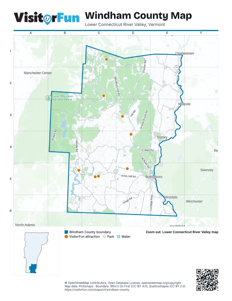
Maps inside Windham County
1 map inside, from the street map of Windham County down.
Street index of Windham County
Each street on the sheet and the grid squares it crosses.
- Vermont Route 100C1, C2, B3, C3, B4, C4, C5, B6, C6
- Vermont Route 30C2, C3, D3, D4
- Rockingham RoadE1, E2
- Vermont Route 9C5, D5
- U.S. Route 5E2, E3
- West River RoadD4, D5, E5
- Vermont Route 11C1
- Vermont Route 112C5, C6
- Coolidge HighwayD5, E5, E6
- Vermont Route 100 NorthC2, C4, B5, C5
- Calvin Coolidge Memorial HighwayE4
- Missing Link RoadE1, E2
- Marlboro RoadD5
- Main StreetC2, D2, E2, C3, E4, E5
- Vermont Route 100 SouthC3
- Bellows Falls RoadE3, E4
- Vermont Route 9 EastC5
- Putney RoadE4, E5
- Canal StreetE2, D5, E5
- Western AvenueD5, E5
- Vermont Route 9 WestB5
- Westminster StreetE2, E3
- Rockingham StreetE2
- Linden StreetE5
- East Main StreetB5, C5
- West Main StreetB5
- High StreetC1, E5
- North Main StreetC1
- Putney Landing RoadE4
- Vermont Route 123E3
- Park PlaceD3, E5
- Chesterfield RoadE5
- United States Navy Seabees BridgeE5
- The SquareE2
- Vermont Route 103 SouthE1
- Jacksonville RoadC6
- Westminster RoadE2, E3, E4
- Fort Bridgman RoadE5, E6
- Route 121C1, D1, E2
- Houghtonville RoadD1, D2
- Saxtons River RoadE2
- Route 121 EastD2, E2
- Route 8AC6
- Vernon StreetE5
- Stratton Mountain Access RoadB2
- Westminster West RoadE2
- Bridge StreetE2, E5
- Old TerraceE2
- Brattleboro RoadE5, D6
- Mount Hermon Station RoadE6
- Stratton Arlington RoadB3, C3
- Windham Hill RoadC1, D1, C2, D2, D3
- Green River RoadC5, D5, D6
- West Hill RoadC2, C3, D3, E4
- West Jamaica RoadB3, C3
- Pleasant Valley RoadE1, E2, B3, D4, D5
- Pikes Falls RoadB2, C2, C3
- Hinesburg RoadD5
- Higley Hill RoadC4, C5
- Grafton RoadD1, D2, D3
- Brookline RoadD2, E2, D3
- Augur Hole RoadC4, D4, C5
- Stage RoadD6
- Dover RoadC4, D4
- Ames Hill RoadC5, D5
- Weatherhead Hollow RoadD5, D6
- Route 35D2, E2
- Pond RoadB2, E2, E3, D4, E6
- Mountain RoadB2, B3, D3
- Guilford Center RoadD5, D6
- Chester RoadD1, D2
- East West RoadD4, E4
- River RoadC2, C3, E3, D4, D6
- Dover Hill RoadC4
- Brook RoadE2, E3, C5, C6
- Townshend RoadD2
- Upper Dummerston RoadD4, D5, E5
- Handle RoadB4
- Kentfield RoadB6
- Middle RoadE4
- Lake Raponda RoadC5
- Kurn Hattin RoadE3
- East Dover RoadC3, C4
- Haystack RoadB4, B5
- South RoadE2, C5
- Coldbrook RoadB4, C4
- Brockways Mills RoadE1
- Houghton Brook RoadE4
- Town Hill RoadC5, B6, C6
- Bunker RoadE4
- Ray Hill RoadB5
- Tyler Hill RoadE6
- Depot RoadD3, D4
- Branch RoadC6
- Patch RoadE3
- Carpenter Hill RoadD5, D6
- Moss Hollow RoadC5
- Athens RoadD2, E2, D3
- Guilford StreetD5
- Huckle Hill RoadE6
- Mann RoadB4, B5
- Hitchcock Hill RoadC1, D1
- Maple StreetE2, D5, E5
- South Main StreetB5, E5
- Dorr Fitch RoadC4
- Tunnel StreetB6
- School House RoadD3, E4
- Horsenail Hill RoadC1
- Auger Hole RoadD4
- Fairground RoadE5, D6
- Atkinson StreetE2
- Brazers WayB2
- Greenleaf StreetD5
- Goodnow RoadC6
- Poverty RowB6, C6
- Pine StreetE2, E5
- Elliot StreetE5
- Johnson's Curve RoadE4
- North Access RoadB4
- Fairview StreetE5
- Tannery RoadB4
- Birge StreetE5
- Washington StreetE2, E5
- Cotton Mill HillE5
- Elm StreetE2, E5
- Kimball HillE4
- South Access RoadB4
- Arch BridgeE2
- Brockway Mills RoadE1
- Goodevaille bridgeC3
- South Wardsboro RoadC3, D3, D4
- East Hill RoadC3, D3, C5
- Grassy Brook RoadD3, D4
- Sunset Lake RoadD4, D5
- Airport RoadB3, E3, B4, C4
- River Road SouthE3, E4
- Cambridgeport RoadE1, E2
- Somerset RoadB4
- West RoadE3, B5, E6
- Black Mountain RoadD4, D5, E5
- Bonnyvale RoadD5
- Sweet Pond RoadD6
- Parker Hill RoadE1, E2
- Putney Mountain RoadD3, D4, E4
- Middletown RoadC1, D1, C2, D2
- Stickney Brook RoadD4
- Jacksonville Stage RoadC6, D6
- Deer Park RoadD5, C6, D6
- Simpson Brook RoadD2, D3
- Newfane Hill RoadD4
- Pine Banks RoadE3
- Baker Brook RoadC4, D4
- East Putney Brook RoadE3
- Back Windham RoadD2, D3
- South Hill RoadC2, C3
- Stratton Hill RoadC4
- Under Mountain RoadC1, C2
- State Forest RoadD3
- Springhill RoadC1, C2, C4, D4
- Butterfield RoadD4, C5
- Morse Brook RoadE3
- Abbott RoadC2, D2, D5
- Burrington Hill RoadB6, C6
- Miller RoadE2, C4, E4, C5, D5
- Reed Hill RoadC5, C6
- Shearer Hill RoadC5
- North Pond RoadD4, D5
- Lower Dover RoadC4, C5
- Blue Brook RoadB4
- Hill RoadD3, D4
- Dam RoadD2, D3, B5, B6
- Upper River RoadD3, D4
- Turkey Mountain RoadC2, C3
- Potter RoadC3
- Collins RoadC4, D4, C5, C6
- Rockingham Hill RoadE2
- Boyd Hill RoadB5, C5
- Valley View RoadC4
- Forest Highway 71B3
- West Windham RoadC2
- Winhall Hollow RoadC1, C2
- North StreetC4, E5
- Eastman RoadD1, E1
- Stagecoach RoadD1, C3
- Grout Pond RoadB3, D3, D4
- Rice Farm RoadD4, D5
- Back Westminster RoadE2, E3
- Old County RoadD4, C5, C6, D6
- Stowe Hill RoadC5
- Cross RoadC2, D2, C3, E3, E4
- Hatch School RoadC5
- Holland Hill RoadD4, E4
- Old Stage RoadD3, E3, C5, C6, D6
- Quarry RoadE3, D4
- Fowler RoadC5, C6
- Kipling RoadE4, E5
- Upper Podunk RoadC3
- Castle Hill RoadC2, B5
- Park Laughton RoadD4, E4
- Landgrove RoadC1
- Camp Arden RoadD4
- Packer Corners RoadD6
- Adams Hill RoadC4
- Hunter Brook RoadC4
- Townsend Dam RoadC3
- Fisher Hill RoadE1, D2, E2
- Parsons RoadC5
- Leach RoadE2
- Davidson Hill RoadE2
- Stowe Mountain RoadC6
- Stark RoadC3, D5
- Thompsonburg RoadC1, C2
- Deer Valley RoadD3
- Darby Hill RoadE2
- Wiswall Hill RoadD3
- Maintenance RoadB2, B3
- Reed RoadD2
- Amidon RoadD6
- East Town Farm RoadE3, E4
- Faulkner RoadB5, B6
- McMillan RoadC6
- Church Hollow RoadC5, D5
- Pennel Hill RoadC6
- Williams RoadE1, C2, D4
- South StreetE2, D5
- Hale RoadD5
- Maple Hill LaneC6
- Anderson RoadD1, E1
- Cabell RoadD1, D2
- Goodaleville RoadC2
- Whites RoadC5
- Hartley Hill RoadE2
- Meadowbrook RoadD5
- Wilmington Cross RoadC5, C6
- Cowpath 40D5
- Ellen Ware RoadD3
- Merrifield RoadB6
- White RoadD1, C3
- Timson Hill RoadD4
- Fuller Hill RoadB5, C5
- Newfane RoadC3
- Lucier RoadC5, D5
- Gates Pond RoadC5
- Sand Hill RoadE2, E3, E4
- Hickory Ridge RoadE3
- Grant RoadC5
- Wheeler RoadD2, E4, C5, E6
- Yeaw RoadC4, D6
- Leonard RoadB4, D4
- Lee RoadD5
- Windmill Hill Road SouthE3
- Beaver Pond RoadD4
- New RoadC4
- Popple Dungeon RoadC1, D1
- Cemetery RoadE2, E3, D4, E4
- Taft Brook RoadC4
- Burbee Pond RoadC2, D2
- Thomas Hill RoadD5
- Old Town RoadB3, C4, E4
- Smith RoadC3, C4, C5, C6
- Bemis Hill RoadE2
- Adams Brook RoadC4
- Little Pond RoadC1
- Aldrich RoadB5, C6
- Upper Dover RoadC4
- Holbrook RoadC6
- Barrows RoadD5
- Ball Mountain LaneC2
- Orchard StreetD5
- Reilly RoadC1
- Hinkley Brook RoadD2
- Hanson RoadC5
- Barker RoadC1
- Fairview AvenueB5
- Franklin RoadE5, E6
- Fred Wright RoadE2, E3
- Broad Brook RoadD5, E5
- Larrabee RoadC4, C6
- Peaked Mountain RoadD3
- Wickopee Hill RoadD4
- School StreetD2, E2, E3, D4, B5, E5, B6
- Newton RoadE6
- Grimes Hill RoadD4
- Melendy Hill RoadC2, D5
- Whitneyville RoadC5, C6
- Chimney Hill RoadB4, B5
- Winhall Station RoadC2
- Hamilton RoadD5, D6
- Woods RoadE4, B5
- White Birch LaneC3, C4
- East Putney Falls RoadE3, E4
- Atcherson Hollow RoadE2
- Haven Hill RoadC2
- Jockey Hollow RoadC4
- Cooper Hill RoadC4
- Hells Peak RoadC1
- Williams StreetC1, E2, D5, E5
- Newell Hill RoadB3, C3
- Westminster Heights RoadE3
- Holland RoadC4
Things to do on the Windham County map
Places on the map
- Algiers
- Athens
- Atherton Meadows Wildlife Management Area
- Ball Mountain Lake
- Ball Mountain Reservoir
- Bellows Falls
- Bemis Pit
- Black Mountain Natural Area
- Brattleboro
- Brattleboro Country Club
- Brookline
- Canoe Brook Nature Preserve
- Chimney Hill
- Deer Run Nature Preserve
- Dover
- Dummerston
- Forest for Learning
- Fort Dummer State Park
- Grafton
- Grout Pond
- Grout Pond Recreation Area
- Guilford
- Halifax
- Harmonyville
- Harriman Reservoir
- Haystack Golf Course
- Jacksonville
- Jamaica
- Jamaica State Park
- Jamalca Pit
- Lake Raponda
- Lake Sadawga
- Lily Pond
- Living Memorial Park
- Londonderry
- Lowell Lake
- Lowell Lake State Park
- Magic Mountain Ski Area
- Townshend State Forest
- Windmill Ridge Nature Reserve
Next to Windham County
- Charlestown
- Hinsdale
- Manchester Center
- North Adams
- Swanzey
- Walpole
- Winchester
© OpenStreetMap contributors, Open Database License, openstreetmap.org/copyright · Map data: Protomaps · Boundary: Who's On First (CC-BY 4.0); Quattroshapes (CC BY 2.0)















