

Washington map
Everett map
About 113,011 people live here (Census Bureau, 2024 estimate). The sheet's index lists 300 streets; Evergreen Way, Holly Drive and Lake Chaplain Road cross the most grid squares. Things to do inside the boundary: Everett Mall and Imagine Children's Museum.
Open the map (PDF, US Letter)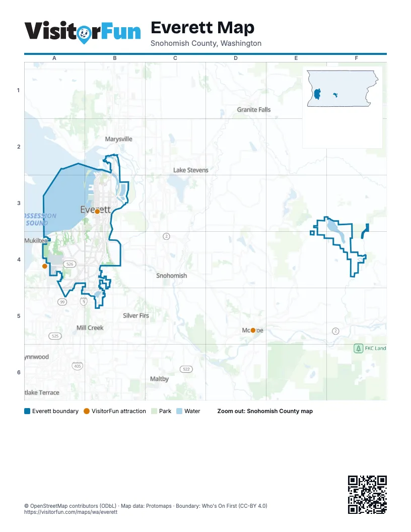
Street index of Everett
Each street on the sheet and the grid squares it crosses.
- Boeing FreewayA4, B4
- State Route 2B3
- Evergreen WayB3, A4, B4, A5
- BroadwayB3, B4
- Rucker AvenueB3, B4
- West Marine View DriveB2, B3
- State Route 529B2, B3
- 19th Avenue SoutheastB4, B5
- Boeing Perimeter RoadA4
- East Marine View DriveB3
- Everett AvenueB3
- Southeast Everett Mall WayA4, B4
- 41st StreetB3
- North BroadwayB3
- State Highway 527B4
- Bothell-Everett HighwayB5
- Southwest Everett Mall WayA4
- Broadway AvenueB4
- 132nd Street SoutheastB5
- North Broadway AvenueB3
- Pacific HighwayA5
- 84th Street SouthwestA4
- Colby AvenueB3, B4
- West Mukilteo BoulevardA3, A4
- Airport RoadA4, A5
- Maple StreetB3
- Hewitt AvenueB3
- Lowell Larimer RoadB4
- South 3rd AvenueB3, B4
- Walnut StreetB3
- Pacific AvenueB3
- Beverly BoulevardB4
- East Mukilteo BoulevardA3, B3
- Alverson BoulevardB2, B3
- East Grand AvenueB3
- South 3rd StreetB3
- Wetmore AvenueB3, B4
- Hoyt AvenueB3, B4
- Grand AvenueB3, B4
- Holly DriveA4, B4, A5
- Hardeson RoadA4
- Riverfront BoulevardB3, B4
- Pine StreetB3
- Seaway BoulevardA4
- McDougall AvenueB3
- West Casino RoadA4
- Beverly LaneA4, B4
- 7th Avenue SoutheastB4, B5
- Cedar StreetB3
- Madison StreetA4, B4
- 19th StreetB3
- 3rd Avenue SoutheastB4, B5
- Glenwood AvenueA4
- 23rd StreetB3
- Olympic BoulevardA3, A4
- 100th Street SouthwestA4
- Chestnut StreetB3
- Merrill Creek ParkwayA4
- 100th Street SoutheastB4
- California StreetB3
- 16th StreetB3
- 75th Street SoutheastB4
- 33rd StreetB3
- 112th Street SoutheastA5, B5
- East Casino RoadA4, B4
- 34th Avenue NortheastB2
- 35th StreetB3
- Lowell Snohomish River RoadB4
- 4th Avenue WestA4
- Commercial AvenueB4
- 36th StreetB3
- 112th Street SouthwestA5
- Smith AvenueB3
- Kasch Park RoadA4
- 52nd Street SoutheastB4
- Wall StreetB3
- Nassau StreetB3
- Ross AvenueB2, B3
- 75th Street SouthwestA4
- Lowell RoadB4
- 37th StreetB3
- Highland AvenueB3
- Sievers Duecy BoulevardA4
- 80th Street SouthwestA4
- 13th Avenue WestA4
- 60th Street SoutheastA4, B4
- 63rd Street SoutheastB4
- South 2nd AvenueB4
- 2nd Avenue SoutheastA4, A5
- Pecks DriveA4, B4
- 5th Avenue WestA4
- 35th Avenue NortheastB2
- Meridian Avenue SouthA4, A5
- Berkshire DriveB4
- 84th Street SoutheastB4
- Dogwood DriveA4
- 92nd Street SoutheastA4, B4
- Hollow Dale PlaceA4, A5
- 108th Street SouthwestA4
- Bruskrud RoadB4
- 110th Street SoutheastB5
- 29th Avenue WestA4
- 88th Street SoutheastB4
- 126th Street SoutheastB5
- 116th Street SoutheastB5
- 50th Street SoutheastB4
- 106th Place SoutheastB4
- 79th Place SoutheastA4, B4
- Corbin DriveA4
- 28th Place NortheastB2
- 55th Street SoutheastB4
- Tower StreetB3
- El Capitan WayB4
- Lenora StreetB4
- Alta DriveB4
- Park DriveB4
- 27th Avenue SoutheastB4
- 115th Street SoutheastA5
- Trojan WayB3
- Officer Dan Rocha WayB3
- Junction AvenueB4
- East Minuteman DriveA4
- Center RoadA5
- Beverly Park RoadA5
- Lake Chaplain RoadE3, F3, F4
- Lombard AvenueB3, B4
- Rockefeller AvenueB3, B4
- Oakes AvenueB3, B4
- 22nd StreetB3
- 18th StreetB3
- 24th StreetB3
- 25th StreetB3
- 21st StreetB3
- Rainier AvenueB3
- Baker AvenueB3
- 26th StreetB3
- Seahurst AvenueA3, A4
- Virginia AvenueB3
- Flukes DrivewayA4
- Federal AvenueB3
- Fulton StreetB3
- 10th StreetB3
- 15th StreetB3
- Diversion Dam RoadF3, F4
- 17th StreetB3
- 32nd StreetB3
- 20th StreetB3
- 13th StreetB3
- 74th Street SoutheastA4, B4
- Riverside RoadB3
- 36th Avenue WestA4
- Smith Island RoadB3
- 8th StreetB3
- 12th StreetB3
- Highland DriveB4
- South 4th AvenueB3, B4
- Silver Lake RoadB5
- Upper Ridge RoadA4
- 47th Street SoutheastB4
- East DriveB4
- 1st Avenue SoutheastA4, A5
- 14th StreetB3
- East Mall DriveB4
- Summit AvenueB3
- West Mall DriveB4
- 34th StreetB3
- Cady RoadB4
- 39th StreetB3
- Olympic DriveB4
- State StreetB3
- 1st Drive SoutheastA4, A5
- Pigeon Creek RoadA3, B3
- Sound AvenueA4
- Elm StreetA3, A4
- 73rd Street SoutheastB4
- Brookridge BoulevardA4
- Fairway DriveA4
- 16th Avenue SoutheastB4, B5
- Crown DriveA3
- Rainier DriveB4
- Lower Ridge RoadA4
- Kromer AvenueB3
- 11th StreetB3
- Cleveland AvenueB3
- 23rd Avenue WestA4
- 18th Avenue WestA4
- 38th StreetB3
- Spruance BoulevardA3, B3
- College AvenueB4
- Norton AvenueB3
- 33rd Avenue WestA4
- Harrison AvenueB3
- 29th Avenue SoutheastB3, B4
- 106th Street SouthwestA4
- Laurel DriveB3
- 108th Street SoutheastA4, B4
- Fowler AvenueB4
- West Marilyn AvenueA4
- 44th Street SoutheastB3
- Shuksan WayA4
- Shore AvenueA4
- Friday AvenueB3
- Ocean AvenueA4
- Cherry WayA4
- Morgan RoadA4, B4
- Fleming StreetB4
- Tulalip AvenueB3
- View Ridge DriveA3
- 10th Drive SoutheastB4, B5
- 61st Street SoutheastA4, B4
- Fletcher WayB3
- Jefferson AvenueB4
- Horseshoe Bend MainlineF4
- Brown Road SoutheastB3
- 9th Drive SoutheastB4, B5
- 100th Place SoutheastB4
- Panaview BoulevardB4
- Associated BoulevardA4
- Railway AvenueB3
- 104th Place SoutheastB4
- Harbor LaneA3, A4
- Delaware AvenueB4
- 90th Street SouthwestA4
- View DriveB4
- Sunset LaneA4
- 8th Avenue WestA4
- Crescent AvenueB3, B4
- 48th Street SoutheastB4
- Jackson AvenueB4
- 51st Place SouthwestA4
- Sharon DriveA4
- Dover StreetA3, A4
- Monroe AvenueB4
- 73rd Street SouthwestA4
- 30th Drive SoutheastB3, B4
- 93rd Street SouthwestA4
- Narbeck AvenueA4
- 46th Street SoutheastB3, B4
- East Beech StreetA4, B4
- 94th Street SouthwestA4
- Walter E Hall RoadA4
- Larlin DriveB4
- McDougal AvenueB4
- 57th Street SouthwestA4
- Howard AvenueB4
- 7th StreetB3
- Alger AvenueB3, B4
- 21st Avenue SoutheastB4, B5
- 27th Drive SoutheastB4
- Glenhaven DriveA3, A4
- Forest Park DriveB3
- 9th Avenue SoutheastB4
- Melvin AvenueB4
- Forest DriveA3, A4
- 40th StreetB3
- 4th Place SoutheastB4
- 51st Street SouthwestA4
- 36th Place NortheastB2
- 42nd Street SoutheastB3
- 56th Street SouthwestA4
- Industry StreetA4
- Lexington AvenueB4
- 62nd Street SoutheastB4
- West View DriveB4
- 9th StreetB3
- 5th StreetB3
- 74th Street SouthwestA4
- West DriveB4
- Wilmington AvenueB4
- West Beech StreetA4
- Cascade DriveB4
- 109th Street SoutheastA4, B4, B5
- Alder StreetA4, B4
- 127th Place SoutheastB5
- Madrona AvenueA3
- 50th Street SouthwestA4, B4
- Columbia AvenueB4
- Terminal AvenueB3
- 19th Place WestA4
- Dakota WayA4
- 25th Avenue WestA4
- Adams AvenueB4
- 25th Avenue SoutheastB4, B5
- Xavier WayB4
- Juniper DriveB4
- Delaware LaneB4
- 23rd Drive SoutheastB4, B5
- Ridgemont DriveA3
- 2nd Drive SoutheastA4
- 118th Place SoutheastB5
- 103rd Street SouthwestA4
- 10th Avenue SoutheastB4
- Creekside LaneB4
- High StreetB3
- 94th Street SoutheastA4, B4
- 107th Place SoutheastB4
- Alpine DriveB4
- Washington AvenueB4
- Heather RoadA3
- 23rd Drive WestA4
Things to do on the Everett map
Places on the map
- 12th Street Marina
- American Legion Memorial Park
- Bay View Yard
- Bayside
- Beverly Lake
- Boeing Lake
- Boeing Ramp
- Boulevard Bluffs
- Cascade Senior High School
- Cascade Shopping Center
- Cascade View
- Cemex
- Claremont Village
- Delta
- Delta Yard
- Everett Mall
- Everett Marina
- Evergreen
- Forest Park
- Glacier View
- Holly
- Japanese Gulch Park
- Jetty Island Park
- Lake Chaplain
- Langus Riverfront Park
- Langus Riverfront Trail
- Legion Memorial Golf Course
- Lowell
- Lowell Riverfront Park
- Naval Station Everett
- Northwest Everett
- Phil Johnson Ballfields
- Pinehurst - Beverly Park
- Port Gardner
- Riverside
- Silver Lake
- South Forest Park
- Valley View
- View Ridge - Madison
- Westmont
Next to Everett
- Granite Falls
- Lake Stevens
- Lynnwood
- Maltby
- Marysville map
- Mill Creek
- Monroe
- Mountlake Terrace
- Mukilteo
- Silver Firs
- Snohomish
© OpenStreetMap contributors, Open Database License, openstreetmap.org/copyright · Map data: Protomaps · Boundary: Who's On First (CC-BY 4.0); Quattroshapes (CC BY 2.0)