

Washington map
Metro Puget Sound map
The sheet's index lists 27 highways; I-5, US 2 and I-90 cross the most grid squares. Things to do inside the boundary: Argosy Cruises, Ballard Locks and Bellevue Square. Also on it: Arlington, Bothell and Carnation.
Open the map (PDF, US Letter)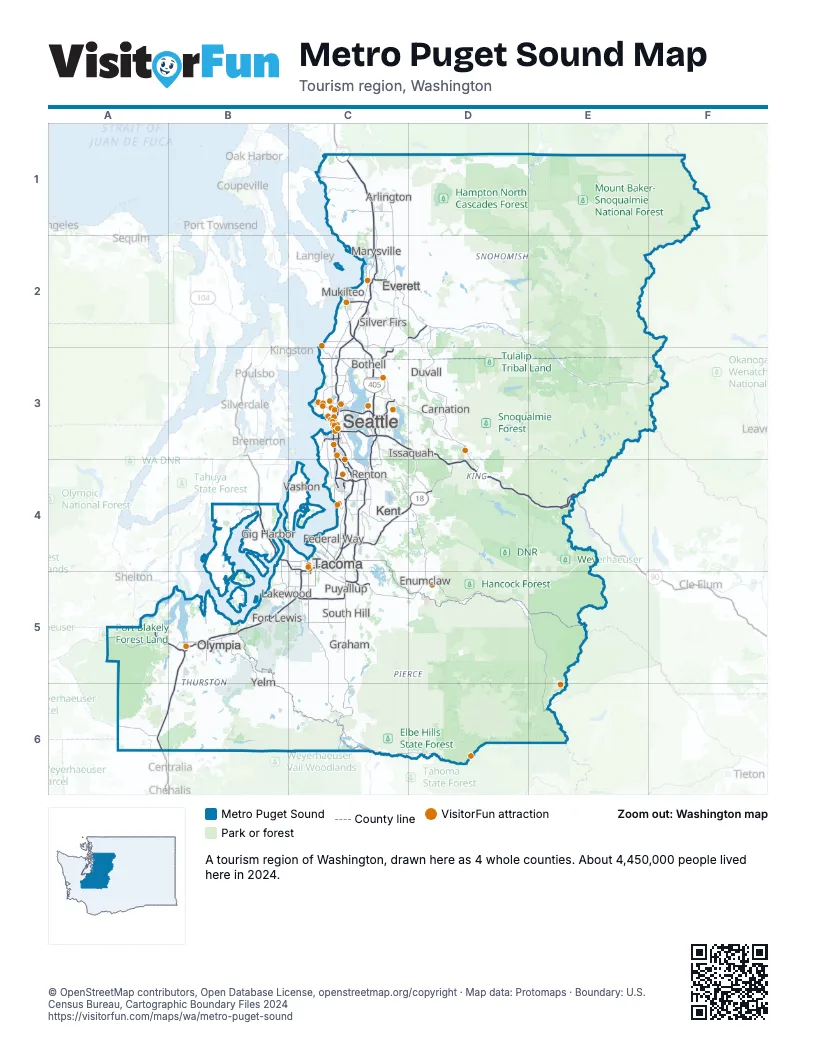
Highway index of Metro Puget Sound
Each highway on the sheet and the grid squares it crosses.
- I-5A6, B5, B6, C1, C2, C3, C4, C5
- I-90C3, D3, D4, E4
- I-405C2, C3, C4
- I-705C4
- US 2C2, D2, E2, E3, F3
- US 12A6
- US 101A5, B5
- SR 7C4, C5
- SR 8A5
- SR 16B4, C4, C5
- SR 18C4, D4
- SR 99C2, C3, C4
- SR 161C5
- SR 167C4, C5
- SR 304C3
- SR 410C5
- SR 509C3, C4
- SR 512C5
- SR 516C4
- SR 518C4
- SR 519C3
- SR 520C3
- SR 522C2, C3, D2
- SR 525C2
- SR 526C2
- SR 527C2
- SR 599C4
Things to do on the Metro Puget Sound map
- Argosy Cruises
- Ballard Locks
- Bellevue Square
- Beneath the Streets
- Bill Speidel's Underground Tour
- Boeing Future of Flight
- Burke Museum
- Capital Mall
- Cascadia Art Museum
- Chateau Ste. Michelle
- Chinatown-International District
- City Sightseeing Seattle
- Climate Pledge Arena
- Clipper Vacations
- Crystal Mountain Resort
- Customized Tours & Charters of Seattle
- Emerald Queen Casino
- Everett Mall
- Experience Olympia & Beyond Visitor Center
- Fremont Troll
- Gas Works Park
- Gum Wall
- Highline SeaTac Botanical Garden
- Imagine Children's Museum
- LeMay - America's Car Museum
- Let's Go Sailing
- Ling Shen Ching Tze Temple
- Mount Rainier National Park
- Mountain Rose Herbs Mercantile
- Muckleshoot Casino Resort
- Museum of Flight
- Museum of Glass
- Museum of History & Industry
- Museum of Illusions Seattle
- Museum of Pop Culture (MoPOP)
- Original Starbucks
- Pike Place Market
- Pioneer Square
- Pioneer Square Historic District
- Quick Shuttle
- Seattle Art Museum
- Seattle Escape Games
- Seattle Glassblowing Studio
- Seattle Ice Cream Cruise
- Seattle Scottish Highland Games
- Seattle-Bainbridge Island Ferry
- Snoqualmie Casino
- Space Needle
- St. James Cathedral
- T-Mobile Park
- Tacoma Glassblowing Studio
- The 5th Avenue Theatre
- The Commons at Federal Way
- The Village at Totem Lake
- Tours Northwest
- Town Center at Lake Forest Park
- Tulalip Resort Casino
- Vashon Heritage Museum
- Vashon Island Studio Tour
- Waterfront Adventures
- Waterland Arcade
- Waterways Cruises & Events
- Westfield Southcenter
- Wing Luke Museum of the Asian Pacific American Experience
Places on the map
- Arlington
- Bothell
- Carnation
- Duvall
- Enumclaw
- Everett
- Federal Way
- Fort Lewis
- Gig Harbor
- Graham
- Issaquah
- Kent
- Lakewood
- Marysville
- Mukilteo
- Olympia
- Puyallup
- Renton
- Seattle
- Silver Firs
- South Hill
- Tacoma
- Vashon
- Yelm
Next to Metro Puget Sound
© OpenStreetMap contributors, Open Database License, openstreetmap.org/copyright · Map data: Protomaps · Boundary: U.S. Census Bureau, Cartographic Boundary Files 2024