

Washington road map
I-82 in Washington map
I-82 is about 128 miles in Washington. It has 36 exits, from Exit 110 at mile 0 to Exit 131 at mile 126. It meets 13 highways; US 395, WA 821 and US 12 meet it in the most grid squares.
Open the map (PDF, US Letter)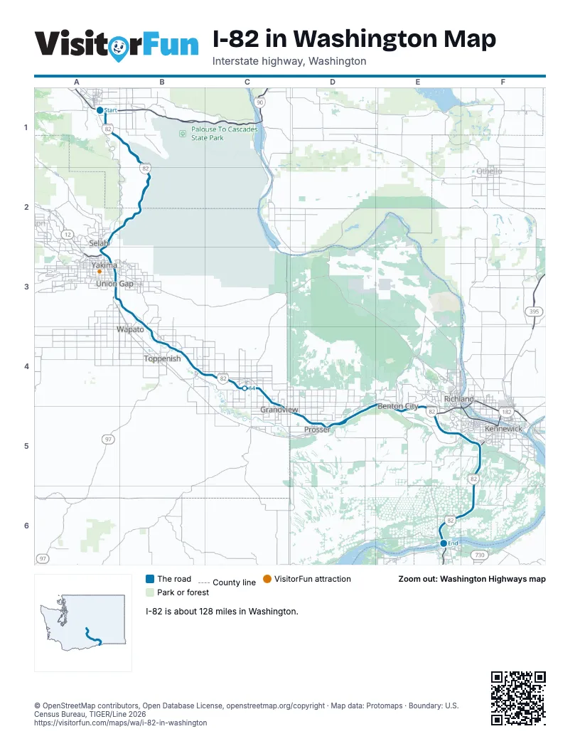
Exits on I-82 in Washington
Each exit in mile order, with its grid square.
- Exit 110mile 0, A1
- Exit 3mile 3, A1
- Exit 11mile 12, B1
- Exit 26mile 25, A2
- Exit 29mile 28, A2
- Exit 31mile 30, A3
- Exit 33Amile 31, A3
- Exit 33Bmile 31, A3
- Exit 33mile 32, A3
- Exit 34mile 32, A3
- Exit 36mile 35, A3
- Exit 37mile 36, A3
- Exit 38mile 36, A3
- Exit 40mile 38, B3
- Exit 44mile 42, B3
- Exit 50mile 47, B4
- Exit 52mile 49, B4
- Exit 54mile 52, B4
- Exit 58mile 56, B4
- Exit 63mile 61, C4
- Exit 67mile 64, C4
- Exit 69mile 66, C4
- Exit 73mile 70, C4
- Exit 75mile 72, C5
- Exit 80mile 76, D5
- Exit 82mile 79, D5
- Exit 88mile 84, D5
- Exit 93mile 90, E5
- Exit 96mile 92, E5
- Exit 102mile 98, E5
- Exit 104mile 101, E5
- Exit 109mile 105, F5
- Exit 113mile 108, F5
- Exit 114mile 110, F5
- Exit 122mile 118, F6
- Exit 131mile 126, E6
Highways I-82 meets
Each highway it meets and the grid squares where they meet.
- I-90A1
- US 97A1
- WA 821A1, A2
- US 12A3, E5
- WA 24A3
- WA 22B4, D5
- WA 223B4
- WA 241C4
- WA 225E5
- WA 224E5
- US 395E6, F5, F6
- WA 397F5
- WA 14E6
Towns along I-82 in Washington
In mile order, with the grid square of each.
- Ellensburgmile 0, A1
- Selahmile 28, A2
- Yakimamile 29, A3
- Terrace Heightsmile 31, A3
- Union Gapmile 34, A3
- Parkermile 38, B3
- Donaldmile 39, B3
- Buenamile 46, B4
- Toppenishmile 48, B4
- Zillahmile 49, B4
- Grangermile 55, B4
- Sunnysidemile 62, C4
- Grandviewmile 69, C4
- Prossermile 76, D5
- Benton Citymile 92, E5
- West Richlandmile 97, E5
- Richlandmile 99, E5
- Kennewickmile 105, F5
© OpenStreetMap contributors, Open Database License, openstreetmap.org/copyright · Map data: Protomaps · Boundary: U.S. Census Bureau, TIGER/Line 2026















