

Washington map
Oak Harbor map
About 24,163 people live here (Census Bureau, 2024 estimate). The sheet's index lists 300 streets; East Pioneer Way, State Route 20 and Torpedo Road cross the most grid squares. Things to do inside the boundary: Pacific Northwest Naval Air Museum.
Open the map (PDF, US Letter)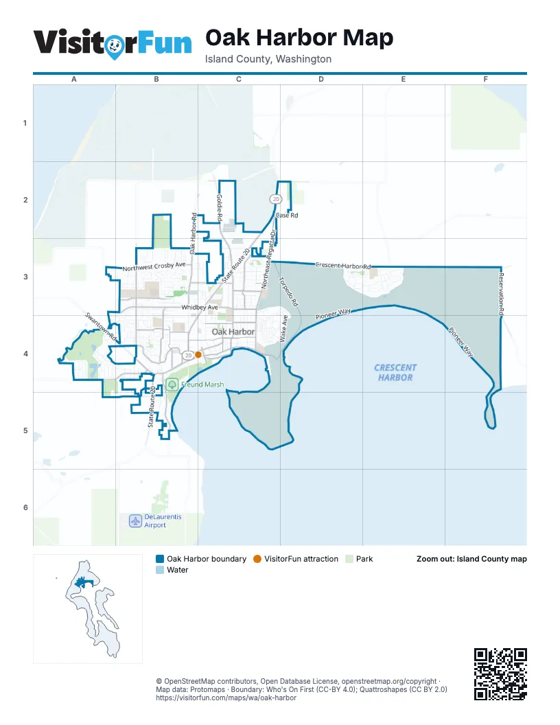
Street index of Oak Harbor
Each street on the sheet and the grid squares it crosses.
- State Route 20C2, C3, B4, B5
- West Fakkema RoadC2, D2
- Southeast Pioneer WayB4, C4
- Northeast Regatta DriveC2, C3
- Southeast Regatta DriveC3, C4
- Torpedo RoadC3, D3, C4, D4
- Northwest Crosby AvenueA3, B3
- Southwest Barrington DriveB4
- Southeast 8th AvenueB4, C4
- East Whidbey AvenueB3, C3
- Southwest Fort Nugent AvenueA4, B4
- Southwest Fairhaven DriveB3, B4
- Northeast Oleary StreetC3
- Northwest 2nd AvenueB3
- Southwest 6th AvenueB4
- Southwest Scenic Heights StreetB4, B5
- West Whidbey AvenueB3
- Southeast 4th AvenueC4
- Northeast 7th AvenueB3, C3
- East Crescent Harbor RoadD3, E3, F3
- Southeast Midway BoulevardC3, C4
- Southwest Heller StreetB3, B4
- Southwest Erie StreetB4
- Northeast Goldie StreetC2, C3
- Northeast Midway BoulevardC3
- Southeast Barrington DriveB4, C4
- Goldie RoadC2
- Northeast 5th AvenueC3
- Reservation RoadF3
- Oak Harbor RoadB2, B3
- Southeast Bayshore DriveC4
- Southeast Ireland StreetC4
- Northwest Heller StreetB3
- North Oak Harbor RoadB3
- North Oak Harbor StreetB3
- Southwest Loerland DriveA3, B3
- Ault Field RoadC2
- Southwest Swantown AvenueB4
- Swantown RoadA4, B4
- Southeast City Beach StreetC4
- Heller RoadB3
- Fort Nugent RoadA4
- Southwest Balda StreetB5
- West Crescent Harbor RoadC3, D3
- Northwest Heller RoadB3
- Southwest Barlow StreetB4
- Maui AvenueC4
- Southwest Swantown RoadB4
- Fairway LaneA4
- Loerland LaneA3
- East Pioneer WayD3, E3, D4, E4, F4
- West Coral Sea DriveC4, D4, C5
- Central DriveD3, E3
- Western DriveD3, E3
- East Coral Sea AvenueD4, C5, D5
- Wake AvenueC3, D3, C4, D4
- West Pioneer WayC4, D4
- Southeast 6th AvenueC4
- Southeast Ely StreetC3, C4
- Southwest Fairway Point DriveA4
- Larch DriveE3
- Southwest 8th AvenueB4
- Northeast 16th AvenueC3
- Vista LoopC5
- Southeast Pasek StreetC3, C4
- Southwest 3rd AvenueB3, B4
- Cascade CircleC5
- Northeast 10th AvenueB3, C3
- Northeast 4th AvenueC3
- Southeast Glencoe StreetC3, C4
- Southwest Robertson DriveA4, B4
- Rainier CircleC5
- Northwest Fairhaven DriveB3
- Northeast Ronhaar StreetC3
- Northeast 8th AvenueC3
- Southwest Putnam DriveA4, B4
- Southwest 24th AvenueB5
- Goldfinch StreetC4
- Northwest Columbia DriveB3
- Mountain CircleC5
- Forest DriveD3
- Northeast 6th AvenueC3
- Northeast 11th AvenueC3
- Southwest 16th AvenueA4, B4
- Southeast 9th AvenueC4
- Southwest Union StreetA4
- Southeast Jerome StreetC3, C4
- Northwest 5th AvenueB3
- Eastern DriveE3
- Northwest Cherry Hill LoopB3
- Southwest 10th AvenueB4
- Northwest Kathleen DriveB3
- Oriole StreetC4
- Southwest Thornberry DriveA4
- Southwest 17th AvenueA4, B4
- Southwest Stremler DriveB4
- Northwest Redwing DriveB3
- Southwest 1st AvenueB3
- Guam AvenueC4, D4
- Northwest 1st AvenueB3
- Southeast Maylor StreetC4
- Northeast Kettle StreetC3
- Jay AlleyC4
- Magnolia WayE3
- Northwest Cathlamet DriveB3
- Southwest Regency DriveB4
- Southwest Judson DriveB4
- Southwest 4th AvenueB4
- Northwest Longview DriveB3
- Lark StreetC4
- Southwest Rock Rose DriveA4, B4
- Southwest Harrier CircleB4
- Southwest 2nd AvenueB3
- Southeast Dock StreetC4
- Canary AlleyC4
- Southeast Oleary StreetC3, C4
- Northwest Dory DriveB3
- Northeast 9th AvenueC3
- South Beeksma DriveB4
- Northwest Outrigger LoopB3
- Case RoadC2, D2
- Northwest Elwha StreetB3
- Southwest Freund StreetB4, B5
- Northeast Harvest DriveC3
- Tulagi AvenueC4, D4
- Northeast Izett StreetC3
- Southwest Bayshore DriveB4
- Barron DriveB3, C3
- Southwest Harbor Vista CircleB4
- Elk LaneC4, D4, D5
- Southwest Victory StreetA4
- South Oak Harbor RoadB3, B4
- Northwest Clipper DriveB3
- Southwest Sunnyside AvenueA4, B4
- Northwest Camella LoopB3
- Northwest Almond LoopB3
- Northeast Sumner DriveC3
- Southwest Kalama LoopB4
- Meadow DriveC4
- Southwest Downfield WayA4
- Northwest Illahee DriveB3
- Technical DriveC2
- Northwest Ensign DriveB3
- Raven DriveC4, D4
- Southeast Quaker StreetC4
- Swan DriveC4, D4
- Southwest Castilian DriveB4
- Southwest Leschi DriveB3
- South West Navigator LoopB4
- Northeast Melrose DriveC3
- Southwest McCrohan StreetB4
- Upsala StreetA3, B3
- Colin LaneC2
- Southwest Berwick DriveA4
- Northeast Nunan LoopC3
- Southeast Catalina DriveC4
- Southwest Fleet StreetB4
- Southwest Dyer StreetB4
- Southwest Kimball DriveB4
- Southwest Xavier DriveA4
- Southwest Rosario PlaceB4, B5
- Northwest 12th LoopB3
- Northwest 6th AvenueB3
- Northwest Lanyard LoopB3
- Solomon DriveE3
- Southwest Tahoe StreetA4
- Southeast 3rd AvenueB4, C4
- Hickory LaneE3
- Northeast Big Berry LoopB3, C3
- Southwest Talon LoopB5
- Southwest Muzzall StreetB4
- Northwest Hiyu DriveB3
- Southeast Neil StreetC4
- Southwest Stroops DriveA4
- Northwest Anchor DriveB3
- West Capital StreetB5
- Northeast Ernst StreetC3
- Brant StreetC4
- Southwest Nienhuis StreetB4
- Northeast Taftson StreetC3
- Heron DriveC3
- Glacier LoopC5
- Northwest Falls Creek LoopB3
- Northwest Lofton LoopB3
- Northeast 1st AvenueC3
- Southeast Ilwaco AlleyC4
- Southwest Dillard LaneB4
- Southwest Orcas StreetB4
- Northwest 8th AvenueB3
- 1st StreetB3, C3
- Northwest Lateen StreetB3
- Northwest Hyak DriveB3
- Clover StreetC4
- Scenic Vista StreetA3
- Southeast Jensen StreetC4
- Southwest Lopez DriveB4
- Southwest Waterside CourtA4
- Northeast Cordero PlaceC3
- Shire StreetB3
- Northwest Quarterdeck LoopB3
- Oak StreetC2
- Northwest Frigate StreetB3
- Northwest Rigging StreetB3
- Spruce LaneE3
- Northwest 7th AvenueB3
- Gemstone DriveC3, D3, C4, D4
- Southeast Cabot DriveB4, C4
- Roeder DriveB3
- Northwest 3rd AvenueB3
- Gun Club RoadB2, C2
- Southeast Fidalgo AvenueC4
- Olympic CourtC5, D5
- Southwest Lansdale StreetB3, B4
- Pine LaneE3
- Southwest Ponsteen DriveB3
- Southwest Vista Park DriveB4, B5
- Blue Lake AvenueC5
- Grouse LaneC4, D4
- Northeast Queets StreetC3
- Southwest Looking Glass LoopB4
- Ridgeway DriveB4, B5
- Southwest London TerraceB4
- Southeast 5th AvenueC4
- Southwest Founders DriveB4
- Sandstone DriveD3, D4
- Southwest Echo LoopB4
- Southwest 7th AvenueB4
- Alder LaneD3, E3
- Northeast 7th CourtC3
- Southwest Petes LaneB5
- Northwest Mizzen DriveB3
- Southwest 9th AvenueB4
- 9th AvenueA3
- Southwest 13th AvenueB4
- Southwest Kaleeton LoopB4
- Northwest Prow StreetB3
- Northeast Narrows AvenueC3
- Northwest Jib StreetB3
- Easy StreetC3
- Southwest Kingma CourtB4
- Osprey StreetC3, C4
- Northwest 12th CourtB3
- Northwest 13th CourtB3
- Southwest Erie CircleB4
- Canary StreetC4
- Dusty LaneE3
- Southwest Bowmer StreetB4
- Southwest Glenmont CourtB4
- Baker CourtC5, D5
- Northeast 24th LaneC2
- Scenic Heights RoadB5
- Southeast 10th AvenueC4
- Southeast Hathaway StreetC4
- EvergreenC3
- Southwest Carnegie StreetA4
- Sandpiper CircleC4
- Southwest Roeder DriveB3, B4
- Southwest Vanguard StreetA4
- Maple LaneE3
- Northwest Key StreetB3
- Robin StreetC4
- Crescent Acres RoadD3
- HemlockB4
- Stuart LaneC5, D5
- Southwest Eagle Vista AvenueB5
- Southwest Aberdeen CourtA4
- Catfish LaneC3
- 2nd StreetB3, C3
- Hemlock DriveE3
- Crater LoopC5
- Scheer LaneB2
- Southwest Winchester StreetA4
- Prow StreetB3
- Eagle LoopC4, D4
- Southwest Waterloo AvenueB5
- Southwest Silverberry StreetA4
- Erin Park RoadC2
- Northeast 2nd AvenueC3
- Northeast 3rd AvenueC3
- Northeast Ellis WayC3
- Northwest Calista CourtB3
- Village DriveC3
- Industrial AvenueC2
- Fir StreetB4
- Northeast Koetje StreetC3
- Southwest Harrier StreetB4
- Northwest Oxford PlaceB3
- Southwest Quilcene LaneB4
- Northeast Riksen WayC3
- Southwest Damnview TerraceB5
- Southwest Ottercrest StreetB4
- Southwest Puffin StreetB4
- Elm LaneE3
- Southwest Periwinkle LaneB4
- Mount Erie LaneC5
- Northwest Clipper CourtB3
- Southwest Grientjes LaneB5
- Southwest Jib StreetB3
- Southeast 2nd CourtC3
- Southwest 11th CourtB4
Things to do on the Oak Harbor map
Places on the map
- 7-Eleven
- Ace Hardware
- Albertsons
- ampm
- Applebee's
- Arby's
- Artists Lounge
- Ashley's Design & Letterman Jackets
- Auld Holland Inn
- AutoZone
- Banner Bank
- Best Friend's Veterinary Center
- Best Western Plus - Harbor Plaza
- Big 5 Sporting Goods
- Broad View Elementary School
- Burger King
- Catalina Park
- Coachman Inn
- Fort Nugent Park
- Freedom Park
- Freund Marsh
- Harbor Station
- Hillcrest Elementary School
- Loers Pond
- Mariner Self Storage
- Midway Center
- North Whidbey Middle School
- Oak Harbor Elementary School
- Oak Harbor High School
- Oak Harbor Intermediate School
- Oak Harbor Libary
- Oak Harbor Town Center
- Olympic View Elementary School
- Ridgehaven Park
- Ridgewood Park
- The UPS Store
- Volunteer Park
- Whidbey Golf Club
- Whidbey Island Naval Air Station Seaplane Base
- Windjammer Park
© OpenStreetMap contributors, Open Database License, openstreetmap.org/copyright · Map data: Protomaps · Boundary: Who's On First (CC-BY 4.0); Quattroshapes (CC BY 2.0)















