

Washington map
Island County map
About 86,478 people live here (Census Bureau, 2024 estimate). The sheet's index lists 300 streets; State Route 525, State Route 20 and South East Camano Drive cross the most grid squares. Things to do inside the boundary: Bayview Corner, Earth Sanctuary and Ebey's Landing National Historical Reserve.
Open the map (PDF, US Letter)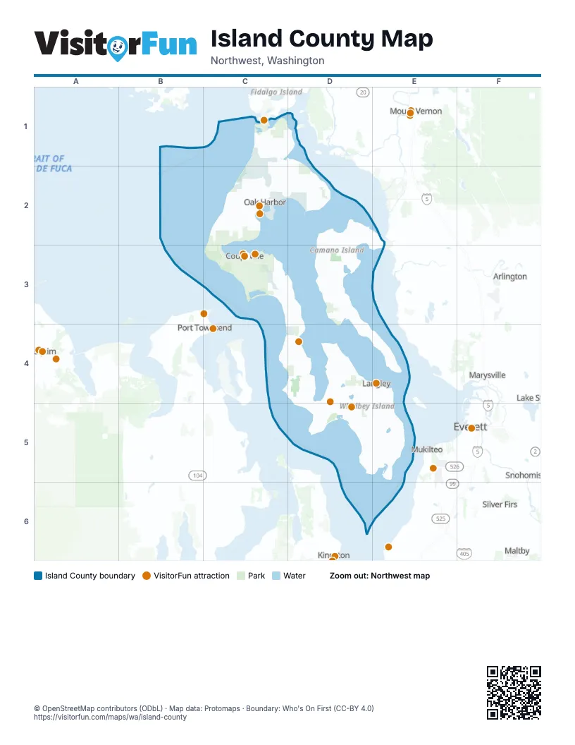
Street index of Island County
Each street on the sheet and the grid squares it crosses.
- State Route 20C1, C2, C3
- State Route 525C3, D3, D4, D5, E5
- State Route 532D2, E2
- West Fakkema RoadC2
- Ferry DockE5
- Deception Pass BridgeC1
- South Engle RoadC3
- South East Camano DriveD3, D4, E4
- South Camano DriveD3, D4, E4
- Maxwelton RoadE4, D5, E5
- South West Camano DriveD3
- Bayview RoadD4, D5
- Engle RoadC3
- Langley RoadE4, E5
- North East Camano DriveD2, D3
- North West Camano DriveD2, D3
- North Sunrise BoulevardD2, D3
- East North Camano DriveD2
- West North Camano DriveD2
- Elger Bay RoadD3
- East Mountain View RoadD3
- Southeast Pioneer WayC2
- Northeast Regatta DriveC2
- Brooks Hill RoadD4
- West Mountain View RoadD3
- 6th StreetD3, E4
- 3rd StreetD3, D4, E4
- 2nd StreetC2, D3, E4
- Southeast Regatta DriveC2
- Cascade AvenueE4
- South Main StreetC3
- Camano AvenueE4
- Park AvenueE4
- Anthes AvenueE4
- Marshview AvenueD5
- De Bruyn AvenueE4
- Main Street SouthC3
- Eagle Road (Ferry Turnaround)C3
- Smugglers Cove RoadC4, D4
- Saratoga RoadD4, E4
- East Harbor RoadD4, D5
- Cultus Bay RoadE5
- West Beach RoadC2, C3
- Jones RoadC1, D1
- North Bluff RoadD3, D4
- Coles RoadD4, D5
- Honeymoon Bay RoadD4
- Silver Lake RoadD2
- Taylor RoadD1, C2, D2
- East Crescent Harbor RoadC2, D2
- Madrona WayC3
- Scenic Heights RoadC2
- West Camano Hill RoadD3
- North Sunset DriveD2, D3
- Humphrey RoadE5
- Race RoadC3, D3
- Fort Casey RoadC3
- Campbell RoadE5
- Wilkinson RoadE4, E5
- Parker RoadC3, D3
- Hastie Lake RoadC2
- Lone Lake RoadD4
- Deer Lake RoadE5
- West Arnold RoadC2
- Double Bluff RoadD4, D5
- Strawberry Point RoadD2
- Monkey Hill RoadC1
- Bush Point RoadD4
- Bob Galbreath RoadE5
- Swantown RoadC2
- Torpedo RoadC2
- Cornet Bay RoadC1
- Bailey RoadD5, E5
- Crawford RoadD4, D5
- Ewing RoadD5
- Ault Field RoadC2
- Swede Hill RoadD5, E5
- Penn Cove RoadC2
- Holst RoadE5
- French RoadD5, E5
- Patmore RoadC3
- Glendale RoadE5
- Nortz RoadC1
- Mutiny Bay RoadD4, D5
- Sills RoadD5
- Keystone Hill RoadC3
- Lancaster RoadD5
- Newman RoadD4, D5
- Fort Nugent RoadC2
- Resort RoadD4
- Charles Porter AvenueC1, C2
- East Sleeper RoadC2, D2
- Crosby RoadC2
- Wanamaker RoadC3
- West Troxell RoadC1
- Polnell RoadD2
- Monroe Landing RoadC2
- Brainers RoadD4
- West Monticello DriveD3
- Reservation RoadD2
- South Mutiny Bay RoadD4
- Woodard AvenueD4, D5
- Libbey RoadC3
- Balda RoadC2
- Heller RoadC2
- Northwest Crosby AvenueC2
- Langley BoulevardC2
- Day RoadD4
- West Sleeper RoadC2
- East Frostad RoadC1, D1
- Dallman RoadE4
- Scatchet Head RoadE5
- Classic RoadD4
- South Fort Casey RoadC3
- Oak Harbor RoadC2
- Southwest Barrington DriveC2
- South Sunset DriveD3
- West Frostad RoadC1
- Fish RoadD5
- West Morris RoadC3
- Surface RoadE5
- Southeast 8th AvenueC2
- East Whidbey AvenueC2
- Northeast Parker RoadC3
- Golf Course RoadC2
- Amble RoadD4
- Lagoon Point RoadC4, D4
- Millman RoadD5
- Fairway LaneC2
- Goldie RoadC2
- Southwest Fort Nugent AvenueC2
- Lowell Point RoadD3
- East Fakkema RoadC2
- Harrington RoadC3
- Southwest Fairhaven DriveC2
- Northeast Oleary StreetC2
- Ducken RoadC1
- Midvale RoadE5
- Sandy Point RoadE4
- Northwest 2nd AvenueC2
- Chapman RoadD3
- Southwest 6th AvenueC2
- Southwest Scenic Heights StreetC2
- Terry RoadC3
- West Whidbey AvenueC2
- South Lone Lake RoadD4
- Southwest Heller StreetC2
- West Crescent Harbor RoadC2
- Clover Valley RoadC2
- Southeast 4th AvenueC2
- Northeast 7th AvenueC2
- East Welcher RoadC3
- Degraff RoadC1
- Miller RoadC2
- 1st StreetC2, D3, E4
- Sullivan RoadC1
- Southeast Midway BoulevardC2
- Christenson RoadD4
- Shoreview DriveD4
- Vista DriveD3
- Southwest Erie StreetC2
- Useless Bay AvenueD5
- Northeast Goldie StreetC2
- Main StreetD5
- North Main StreetC3
- Broadmoor RoadD4
- Sidney StreetC2
- Rocky Point DriveD2
- Southwest Swantown AvenueC2
- Northeast Midway BoulevardC2
- Andreason RoadD4
- Northwest Broadway StreetC3
- Southeast Barrington DriveC2
- East Camano Hill RoadD3
- Brokaw RoadD2
- Northeast 9th StreetC3
- West Welcher RoadC3
- Houston RoadD3
- Myrtle AvenueD4, D5
- Northeast 5th AvenueC2
- Southeast Bayshore DriveC2
- Sunnyshore DriveD4, E4
- Southeast Ireland StreetC2
- Northwest Heller StreetC2
- North Oak Harbor RoadC2
- North Oak Harbor StreetC2
- Loerland LaneC2
- Southwest Loerland DriveC2
- Scott RoadD3, D5
- Northwest Coveland StreetC3
- Stewart RoadD4, D5
- East Morris RoadC3
- South Bayview RoadD5
- Wonn RoadD4
- Orion AvenueC2
- East Monticello DriveD3
- Southeast City Beach StreetC2
- Southwest Balda StreetC2
- Enterprise RoadC1
- Howard RoadD5
- Northwest Heller RoadC2
- Northeast Leach StreetC3
- Southwest Barlow StreetC2
- Southeast Terry RoadC3
- Maui AvenueC2
- Southwest Swantown RoadC2
- Northwest Madrona WayC3
- Commercial StreetE5
- East Saratoga RoadD4
- Marble RoadD2
- North Monkey Hill RoadC1
- Zylstra RoadC2
- Utsalady RoadD2, E2
- East Pioneer WayC2, D2
- Heggenes RoadE5
- Arrowhead RoadD2, D3
- South Ebey RoadC3
- Goss Lake RoadD4
- Beach DriveD3, D4
- Devries RoadD2
- East Troxell RoadC1, D1
- West Cross Island RoadD3
- Wahl RoadD5
- Possession RoadE5
- Fox Spit RoadD4
- Lehman DriveD3
- Fort Ebey State Park RoadC3
- Intrepid RoadC1, C2
- South Camano Ridge RoadD3
- Lakeside DriveD4
- Green RoadD2
- Saratoga StreetC1, C2
- Oakes RoadC3, D3
- Boon RoadC2
- Deception Pass State Park RoadC1
- Highland DriveC2, D3
- Juniper Beach RoadD2, D3, E3
- Lawson RoadD3
- Lexington StreetC1, C2
- Thompson RoadD4, D5
- Goss Ridge RoadD4
- Country Club DriveD3, D5
- Shoreline DriveD4, E4
- West Henni RoadC1
- Cameron RoadD3, D4, D5
- Camano Island State Park RoadD3, D4
- Michael WayD3
- Hoffman RoadC1, C2
- Hunt RoadC2
- Lake DriveD3
- Emil RoadD4, D5
- Cook RoadC3, D3
- West Dry Lake RoadD3
- Tillicum WayD2
- Pioneer Park PlaceD5
- Rocky Point RoadC2
- Dodge RoadD2, D3
- North Surfcrest DriveC1
- Admiralty WayD3, D5
- Bonnie LaneD3
- Eastpoint DriveD4
- Central DriveC2, D2, D3
- Sunlight Beach RoadD5
- Jewett RoadE5
- Craw RoadD5, E5
- Wilson RoadC2
- Shore AvenueD5
- Glacier Peak DriveD3
- Riepma AvenueC2
- Russell RoadD3
- Log Cabin RoadE5
- West Coral Sea DriveC2
- Rhododendron Park RoadC3
- Bells Beach RoadD4
- Rekdal RoadD2
- Sandy Hook DriveE5
- Shumway RoadD3
- North Camano Ridge RoadD3
- Quade RoadD5, E5
- Smith RoadE2, E3
- Barnum RoadD3
- Keystone AvenueC3
- Haven PlaceD4
- Peters RoadD4
- Goodell RoadD4
- Bercot RoadD4
- Busby RoadD2
- Van Dam RoadC2
- East Henni RoadC1, D1
- Vesper WayD3
- Ellwood DriveD4
- Lake Wood PlaceC1, D1
- Jacobs RoadC3
- Chase WayD3
- New Morning RoadD3
- Plum Creek LaneC3
- Western DriveC2, D2
- Dugualla RoadD1
- Lola LaneD4
- Wagner RoadC2, D3
Things to do on the Island County map
Places on the map
- Admiralty Bay
- Barnum Point County Park
- Cama Beach State Park
- Camaloch Golf Course
- Camano
- Camano Island State Park
- Camano Ridge
- Casey Conference Center
- Clinton
- Coupeville
- Coupeville Airpark
- Coupeville Solid Waste Complex
- Cranberry Lake
- Cranberry Lake Campground
- Crescent Harbor
- Crockett Lake
- Crockett Lake Preserve
- Cultus Bay
- Deer Lagoon
- Deer Lagoon Preserve
- Deer Lake
- Deer Lake Drainage
- DeLaurentis Airport
- Double Bluff
- Double Bluff County Park
- Dugualla Bay
- Dugualla State Park
- Earth Sanctuary
- Ebey's Landing National Historical Reserve
- Ebey's Landing State Park
- Elger Bay
- Elger Bay Trust Land
- Fort Casey State Park
- Fort Ebey State Park
- Fossek Farm
- Freeland
- Freund Marsh
- Gallery Golf Course
- Goss Lake
- Naval Air Station Whidbey Island
Next to Island County
- Arlington
- Everett map
- Kingston
- Lake Stevens
- Maltby
- Marysville map
- Mount Vernon
- Mukilteo
- Port Townsend
- Sequim
- Silver Firs
- Snohomish
© OpenStreetMap contributors, Open Database License, openstreetmap.org/copyright · Map data: Protomaps · Boundary: Who's On First (CC-BY 4.0); Quattroshapes (CC BY 2.0)