

Washington map
Port Angeles map
About 20,112 people live here (Census Bureau, 2024 estimate). The sheet's index lists 300 streets; West 18th Street, West 12th Street and West 14th Street cross the most grid squares. Things to do inside the boundary: Coho Ferry, Field Arts & Events Hall and Port Angeles Fine Arts Center.
Open the map (PDF, US Letter)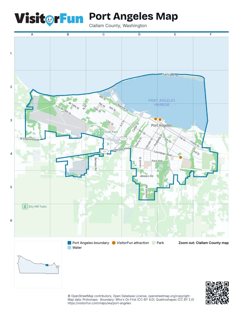
Street index of Port Angeles
Each street on the sheet and the grid squares it crosses.
- East 1st StreetE3, E4, F4
- East Front StreetE3, E4, F4
- West Lauridsen BoulevardB3, C3, C4, D4
- Tumwater Truck RouteD3, C4, D4
- Lauridsen BoulevardD4, E4
- Olympic HighwayB4, C4, D4
- South Lincoln StreetD3, E3, D4
- East Lauridsen BoulevardD4, F4
- Tumwater Truck RoadC4
- North Lincoln StreetE3
- Marine DriveC2, C3, D3
- South Race StreetE3, E4
- West 1st StreetD3, E3
- West Front StreetD3, E3
- North Race StreetE3
- West 18th StreetA2, B2, A3, B3, C3, C4
- West 8th StreetC3, D3
- East 5th StreetD3, E3, E4, F4
- South Peabody StreetE3, D4, D5
- South C StreetC3, D3, C4
- East 8th StreetD3, D4, E4
- West 16th StreetC3, C4, D4
- Hurricane Ridge RoadE4, E5
- South Mount Angeles RoadE4, E5
- South Airport RoadB3, B4
- West Edgewood DriveB3, A4, B4
- Lower Elwha RoadA3, A4
- North Peabody StreetE3
- Ediz Hook RoadC2, D2, E2
- West 12th StreetB2, B3, C3, D3, D4
- West 14th StreetB2, B3, C3, D3, D4
- West 6th StreetC2, C3, D3
- West 5th StreetC2, C3, D3
- 10th StreetB2, C2, C3, D3
- South Laurel StreetD3, D4, D5
- West 11th StreetC3, D3, D4
- West 15th StreetB3, C3, D4
- South Cherry StreetD3, D4
- East 4th StreetD3, E3, E4, F4
- South Oak StreetD3, D4
- East 6th StreetD3, E4, F4
- East Park AvenueD4, E4
- East 2nd StreetE3, E4, F4
- East 7th StreetD3, D4, E4
- West 13th StreetC3, D3, D4
- West 9th StreetC3, D3, D4
- East 3rd StreetD3, E3, E4, F4
- Critchfield RoadA3, B3
- South Cedar StreetD3, D4
- South Chase StreetE3, D4
- South Valley StreetD3, D4
- South Pine StreetD3, D4
- East 9th StreetD4, E4
- Golf Course RoadF4, F5
- South B StreetC3, D3, C4
- South D StreetC3, D3, C4
- South A StreetD3, C4, D4
- South Francis StreetE3, E4
- Old Mill RoadD5
- West 7th StreetC3, D3
- South Washington StreetE3, E4
- 7th StreetC2, C3
- South E StreetC3, D3, C4
- East 10th StreetD4, E4
- O StreetB2, B3
- Whidby AvenueD4, E4
- East Georgiana StreetE3, E4, F4
- N StreetC2, B3
- South I StreetC3
- West 10th StreetB2, D3, D4
- South Vine StreetE3, D4, E4
- South L StreetC2, B3, C3
- South Eunice StreetE3, E4, D5, E5
- South F StreetC3, C4
- Viewcrest StreetD4, E4
- Del Guzzi DriveF4
- South Albert StreetE3, E4
- East 11th StreetD4, E4
- South Liberty StreetE4
- South K StreetC2, C3
- Service roadE4, F4, F5
- Milwaukee DriveB2, C2, B3
- East Ennis Creek RoadF3, F4
- West 4th StreetC2, D3
- West Fairchild Airport RoadB3
- 16th StreetB3, C3
- Caroline StreetE3, E4, F4
- Rook DriveE5
- Lopez AvenueD4, E4
- West 3rd StreetD3
- Vashon AvenueD4, E4
- Campbell AvenueE5
- West 2nd StreetD3, E3
- South G StreetC3
- South Chambers StreetE4
- Eclipse West DriveB4
- South H StreetC3
- 4th StreetC2
- Orcas StreetD4
- East 12th StreetD4, E4
- South Ennis StreetE4
- Eclipse Industrial ParkwayB4
- McDougal AvenueE4, E5
- North Ennis StreetF3, E4, F4
- Porter StreetE4, E5
- Park Access RoadD4, E4
- Penn StreetF4
- M StreetC2, C3
- South Fairmont AvenueC4
- McDonald StreetB2, B3
- South Regent StreetD4, D5, E5
- Rayonier Access RoadF3, F4
- South M StreetC3
- West 17th StreetC3, C4
- East Lindberg RoadF4
- Butler StreetB3
- West 19th StreetB3, C3, C4
- Eckard AvenueE5
- North Jones StreetE3, E4
- North Liberty StreetF3, E4
- South Jones StreetE4
- West Hill StreetC2
- 8th StreetC2, C3
- East Ahlvers RoadD5
- West Ahlvers RoadD5
- Boathaven DriveD3
- Columbia StreetE3, F3
- West Park AvenueD4
- West Spruce StreetC4
- Rhodes RoadD5
- North Chambers StreetE3, E4
- East Woodhaven LaneF5
- North Francis StreetE3
- Benson RoadC4, B5, C5
- Grant AvenueE4
- Olympus AvenueE4
- West Samara DriveB3
- Craig AvenueE4, E5
- Canyon Edge DriveD5, E5
- Forrest AvenueD4
- Fogarty StreetD4
- South Alder StreetE4
- East Scribner RoadD5
- Columbus AvenueD4
- Seamount DriveC2, C3
- West Saddle Club RoadA3
- Gagnon RoadA4
- Westview DriveC3
- South Newell RoadC4
- Melody LaneF4
- Tumwater StreetD3
- Valley Creek DriveD5
- South Maple StreetD4, D5
- West Glenwood StreetC4
- Evans AvenueC2
- Dolan StreetD4
- Hancock AvenueD4
- Motor StreetD4
- North Eunice StreetE3
- East 13th StreetD4
- Green MidwayC3
- Crabapple StreetD5
- Owen AvenueB3
- Old Joe RoadC4
- Ennis CutoffF4
- Homestead AvenueE5
- East Maddock RoadF5
- Doyle RoadC4
- West Madrona StreetC4
- Hillcrest StreetD5
- West Nicholas RoadC4
- North Cedar StreetD3
- Park View LaneC3
- West Hazel StreetC4
- Service Access RoadD4, E4
- Water StreetE3, F3
- Church AvenueE5
- Dutch DriveB2
- Harbor Crest StreetF3, F4
- Discovery LoopB2, B3
- Joshua StreetB2
- Hamilton WayC3
- Morning CourtE5
- South Coyote Run LaneD5
- North Albert StreetE3
- Juniper LaneD5
- Dunker DriveB2, B3
- North Washington StreetE3
- Wolcutt StreetF4
- Yellow MidwayC3
- North Laurel StreetE3
- North Oak StreetD3
- Village CircleF4
- Fields DriveB4
- South Evans AvenueC3
- Oakcrest LoopD4
- Blue MidwayC3
- South Wabash StreetE5
- Bent Cedars WayE5
- Page StreetD5
- P StreetB2
- Red MidwayC3
- Park Knoll DriveD5
- South Lindberg RoadF4
- Hawthorne PlaceD5
- Madeline StreetB2
- Flores StreetB2
- Oakcrest AvenueD4
- Gakin RoadC4
- South Euclid AvenueC4
- South Reyes StreetB3
- Creekside North DriveD5
- Village PlaceF4, F5
- Eunice StreetE4
- West Edgewood PlaceD4
- West Duval PlaceB4
- Thistle StreetD5, E5
- Apple LaneD4
- Eclipse RoadC4
- Seabreeze PlaceC3
- West Railroad Avenue - lilút súɬD3, E3
- North Vine StreetE3
- Marie View DriveB3
- Pear PlaceB2
- Georgiana StreetE3
- South Currier CourtF4
- West Fountain StreetC4
- Driftwood PlaceB3
- East Railroad AvenueE3
- Galaxy PlaceD5
- Rolling Hills DriveB2, B3
- Franklin LaneE4
- McGill AvenueE5
- Pendley CourtB3
- Willow AvenueE5
- Benjamin AvenueE5
- East Nancy LaneF4
- West Columbus AvenueD4
- East Wabash StreetE5
- Aurora CourtB3
- Cathleen StreetB2, B3
- Highland AvenueE4
- Christman PlaceF4
- Forest TrailE5
- Arbutus LaneB3
- South Delores PlaceB3
- Apple Tree LaneB2
- City Light PlaceD4, D5
- South Center StreetE4, E5
- Eckard PlaceE5
- Dogwood PlaceD5
- Nygren PlaceE5
- Orchard AvenueB2
- Heritage CourtB2
- Hill CircleD5, E5
- Rose StreetD5
- North Alder StreetF4
- Hillcrest DriveD5
- South Seaview CircusC2
- Black Diamond RoadD4
- Park LaneD4
- Estes CourtC2
- Solar LaneE5
- Mill Creek CourtD5
- Bryson AvenueE4
- Peach CourtB2
- Cherry CourtB2
- South CenterE5
- Victoria StreetE3
- Burch AvenueE5
- East Lambert AvenueF4
- Alderwood CircleD4
- Grants View LaneD4, D5
- Elizabeth PlaceF4
- Plum CourtB2
- Vista View DriveD5
- Jeri Lynn StreetB2
- Canyon CircleE5
- Albert StreetD5
- South Upland LaneD5
- Fountain StreetC4
- Glenbrook CircleE5
- Meadow CircleD5
- South Pacific VistaB3
- Ediz Hook Boat LaunchE2
- Boulevard CourtE4
- South Woodside CourtB3
- North Baker StreetF4
- Oak LaneD4
- Sea View CircleC2
- South N StreetC2
- North Chase StreetE3
- Renee LaneB2
- North Cherry StreetD3
- South Samara PlaceB3
- East Rose StreetD5, E5
- Rolling Hills CourtB2
- East Keller DriveF4
- South Blue Water ViewE4
- Clipper CoveC3
Things to do on the Port Angeles map
Places on the map
- Airport Business Park
- Big Boy Pond
- Civic Field
- Clallam County Fairgrounds
- Coast Guard Air Station
- Ediz Hook
- Emerald Mobile Home RV Park
- Erickson Playfield
- Extreme Sports Park
- Franklin Elementary School
- Hamilton Elementary School
- Jefferson Elementary School
- Jessie Webster Park
- Lincoln Park
- Ocean View Cemetary
- Olympic Medical Center
- Olympic R/C Modelers
- Pebble Beach Park
- Peninsula Golf Club
- Port Angeles BMX Park
- Port Angeles Boat Haven
- Port Angeles Dog Park
- Port Angeles Harbor
- Port Angeles High School
- Port Angeles Plaza
- Port Angeles Regional Transfer Station
- Port Angeles Seaplane Base
- Shane Park
- Stevens Middle School
- The Lagoon
- The UPS Store
- Valley Creek Estuary Park
- Volunteer Field
- Webster's Woods Art Park
- William R. Fairchild International Airport
© OpenStreetMap contributors, Open Database License, openstreetmap.org/copyright · Map data: Protomaps · Boundary: Who's On First (CC-BY 4.0); Quattroshapes (CC BY 2.0)















