

Washington map
Ridgefield map
About 15,359 people live here (Census Bureau, 2024 estimate). The sheet's index lists 300 streets; Pioneer Street, South 6th Way and South Hillhurst Road cross the most grid squares. Also on it: Abrams Park, Discovery Ridge and McCuddy's Marina.
Open the map (PDF, US Letter)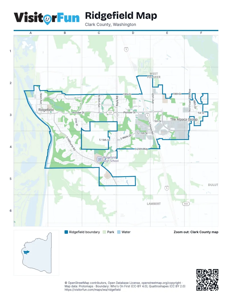
Street index of Ridgefield
Each street on the sheet and the grid squares it crosses.
- Pioneer StreetA3, B3, C3, D3, E3
- South Hillhurst RoadB3, B4, C4, C5
- South Royle RoadD3, C4, D4, C5
- South Union Ridge ParkwayE3, F3
- Northeast 10th AvenueF2, F3
- North Royle RoadD2, D3
- Northwest Hillhurst RoadC5, D5
- South 85th AvenueF3
- Northeast 259th StreetF3
- North 10th StreetC2, D2, E2, F2
- North Pioneer Canyon DriveC3, D3
- North Heron DriveA2, B2, A3, B3
- South Timm RoadD3, E3, E4
- North 65th AvenueE2, E3
- South 5th StreetE3, F3
- South 6th WayB3, C3, D3, E3, F3
- North Main AvenueA2, A3
- South 11th StreetD4, E4
- South Wells DriveD4
- North 35th AvenueC2, C3
- North Reiman RoadB2, B3
- South 10th StreetE3, E4
- Division StreetA3, B3
- South 56th PlaceD3
- South 65th AvenueE3
- South 74th PlaceE3
- Northwest 51st AvenueB2
- Northwest 11th AvenueE2
- North Discovery DriveD3
- Northwest Carty RoadC5
- South Sevier RoadB4, B5
- South Dolan RoadE3, E4
- South 8th WayB3, C3, D3
- Northwest 289th StreetD2, E2
- North 1st AvenueA2, A3
- North 88th DriveF2, F3
- South 3rd WayB3, C3, D3, F3
- North 4th StreetF3
- Northwest 229th StreetC5
- North 56th PlaceD3
- South Kennedy DriveC5
- South Refuge RoadB4
- North 5th WayB3, C3
- South 15th StreetC4, D4
- North 3rd WayB3, C3, F3
- South 21st PlaceB3, B4
- South 20th WayD4
- South White Salmon DriveB4, C4
- North 5th StreetD3, F3
- South Taverner DriveB4
- South Willow DriveC5
- South 1st StreetC3, F3
- South 16th DriveB4, D4
- North 32nd CourtC2, C3
- South 35th PlaceC3, C5
- North 40th AvenueC2, C3
- South 19th StreetD4
- North Falcon DriveB2, B3
- South Red Tail LoopC5
- North 91st AvenueF2, F3
- North 9th WayB2
- Northwest 26th AvenueD3
- North 2nd WayB3, C3, D3, E3
- North 8th WayB2
- South 17th WayB4, C4
- South Great Blue RoadB4
- South 15th CourtB3, B4
- North 6th StreetD3, F3
- North Railroad AvenueA2, A3
- South 15th WayB4
- South 88th AvenueF3
- North 4th WayB3, C3
- North Helens View DriveC2, C3
- South 7th WayC3, F3
- South 40th PlaceC4, C5
- North 30th DriveC3
- North 9th StreetD2, F2
- South Cornett DriveC4
- South 48th PlaceD3, D4
- South Discovery DriveD3, D4
- North 3rd AvenueA3
- South 13th StreetE4
- South 36th DriveC5, D5
- Maple StreetA3
- South Green Pastures DriveC5, D5
- South 46th PlaceD4
- South 4th WayB3, C3, F3
- South Ridge WayD4, E4
- South Dusky DriveB4
- South Fieldcrest DriveC4, D4
- South Royal CourtC4
- South 39th DriveC3
- South Settler DriveC3, D3
- Mill StreetA3
- Abrams Park RoadA3, B3
- North 10th StreethD2, E2
- South 44th LaneC5, D5
- South Lake River TerraceB4
- South Nighthawk RoadB4
- Simons StreetA3, B3
- South Bertsinger RoadB3, C3
- North 4th AvenueA3
- North 5th AvenueA3
- Shobert StreetB3
- South 17th DriveD4
- South 47th AvenueD3
- South 18th DriveD4
- South 24th PlaceB3, B4
- South 10th WayC3, C4
- South 41st PlaceC4, C5
- South 2nd WayB3, C3
- South Gee Creek LoopB3
- North 7th StreetF3
- North 1st StreetC3, F3
- South Harrier RoadB4
- North Lark DriveB2, B3
- South 11th WayC4, D4
- South 16th WayB4, C4
- North 1st WayC3, D3
- South 19th PlaceB3
- South 44th AvenueC4
- North Allen Creek DriveC3
- South Shobert StreetA3, B3
- South Oak RoadB3, B4
- North Auburn PlaceE2
- South 25th PlaceB3
- South Cispus WayB4
- South 29th CourtC4
- North 3rd CircleC3, F3
- South Cherry Grove WayC4, C5
- South 69th PlaceE3
- South 78th PlaceE3
- North 18th PlaceB2, B3
- South 42nd PlaceC5
- South Meadowlark LoopB4
- North Horns Corner DriveC3
- South 50th PlaceD4
- South 47th PlaceD4
- South Meadowlark DriveB4
- South 23rd CourtB3
- South Taverner CourtB4
- South 34th PlaceC3
- North McCanta WayC3
- South Cedar Ridge DriveC3
- South Osprey DriveB4
- South 31st CourtC4
- North Noble LoopD2
- South 3rd StreetF3
- South 11th PlaceE4
- South 8th AvenueB3
- North 20th PlaceB3
- South 32nd PlaceC3
- North 47th AvenueD2, D3
- South 5th AvenueA3
- South Chukar DriveB4
- South 87th AvenueF3
- Clark CollegeE3
- South 4th AvenueA3
- South Arwana LaneD5
- North 39th CourtC3
- South 29th PlaceC3, C4
- North 2nd LoopF3
- North 78th PlaceE3
- North 8th StreetD3, F3
- South 1st WayB3
- South 12th CircleC4, D4
- North 89th LoopF3
- South Harper Valley WayC4, C5
- Sargent StreetA3
- South 11th CircleC4, E4
- South Star View LoopC5
- North Ridgefield Woods DriveC2, C3, D3
- South 3rd AvenueA3
- North 33rd CourtC3
- North 34th CourtC3
- South 77th PlaceE3
- North 53rd PlaceD3
- South 51st PlaceD4
- South Rocher WayF3
- South 14th WayC4
- North Green Gables LoopC3
- North 8th AvenueB3
- North Russet PlaceF3
- South 43rd PlaceC4, C5
- Abrams ParkroadB3
- South 89th AveF3
- South 90th PlaceF3
- North 1st CircleD3, E3, F3
- North 93rd AvenueF2, F3
- South Old Pioneer WayB3
- South 5th WayC3, F3
- North 43rd PlaceC3
- South Sockeye DriveC4, C5
- North Fairhope PlaceE2
- North 22nd CourtB3
- South Nisqually AvenueB4
- South 22nd CircleB4, C4
- South Titan DriveB4
- South 4th DriveB3, C3
- North Squire DriveD2, D3
- South 7th AvenueB3
- Cemetery RoadB3
- North 38th PlaceC3
- Northridge DriveB3
- North Kemper LoopC3
- South 39th PlaceC5
- Riverview DriveB3
- South 11th CourtB3, B4
- South 50th CourtD4
- South 91st PlaceF3
- Depot StreetA2
- South Hay Field CircleC4
- North 4th PlaceA3
- North 41st PlaceC3
- South Farm View LoopC4
- South 22nd PlaceB3, B4
- South 23rd WayC4
- South Waters Edge WayC4
- North 48th AvenueD2, D3
- Cook StreetA2
- North 13th PlaceB2
- North 9th AvenueB3
- North 86th PlaceF3
- North Raven DriveB2
- South 1st CircleC3, D3
- Elm StreetA3
- South 14th PlaceB3
- South Sunset LaneB3
- South 88th DriveF3
- Hall StreetA3
- North 23rd PlaceB3
- South Mountain PlaceD4
- South Coho PlaceC4
- South Quail Hill PlaceE4
- North 10th WayB2
- South 21st CourtB4, B5
- South Sauk WayB4
- South 14th CourtB4
- North 9th CircleA2, B2
- North Avery DriveC3
- South Chinook DriveC4, C5
- Ash StreetA3
- North Kelsy PlaceC3
- South 9th WayC3
- North 90th AvenueF2, F3
- Northeast 2nd AvenueE2
- South 68th CourtE3
- West Division StreetA3
- South 13th CourtB3
- South Phoebe DriveB4
- South 26th AvenueC4
- South 30th PlaceC3
- South Ortman DriveE3
- North 44th PlaceD3
- South Union PlaceE4
- South Winery WayC4
- North Layla PlaceC3
- South 2nd PlaceA3
- North 28th PlaceC3
- South 26th PlaceC3
- North 49th AvenueD3
- South Main AvenueA3
- North 9th PlaceB2, B3
- North 19th CourtB3
- North 39th PlaceC3
- North 7th WayC3, D3
- South Quail Crossing PlaceE4
- North Abernathy CircleC2
- South 18th CircleB4
- South Harrier CircleB4
- Northwest 4th CourtE4
- South Wind River WayB4
- South 92nd PlaceF3
- Northwest 5th AvenueE2
- South 89th PlaceF3
- South 14th CircleB4
- North Madison CircleE2
- South 9th CircleB3, B4
- South Coopers DriveC5
- South Sevier CircleB4
- 9th LaneB3, B4
- South Eagle Ridge DriveC4
- South 2nd LaneF3
- South 93rd PlaceF3
- South 15th CircleB4
- North 41st AvenueC3
- South 2nd StreetC3
- South 44th PlaceC4
- South Nighthawk CircleB4
- North 35th PlaceC3
- Northeast 264th StreetF3
- South 9th CourtB3
- South 38th WayC5
- North Gibert CourtC2
- Railroad AvenueA2
- South 12th CourtB3, B4
- South 6th CircleC3
- South Quail Run PlaceE4
- North 42nd PlaceC3
- South Brookside PlaceC4
Places on the map
- 7-Eleven
- ABC's & 123's
- Abrams Park
- ampm
- Blue Heron Community Garden
- Boathouse 24
- Bob's Automotive
- Camp Bow Wow
- Center Market
- Clark College
- Columbia Credit Union
- Community United Methodist Church
- Costco
- Costco Gas Station
- Country Cafe
- DeMelo Park
- Discovery Ridge
- Gougér Cellars Winery
- Heron Gate
- Horns Corner Park
- In-N-Out Burger
- iQ Credit Union
- Junction Park and Ride
- Legacy Town Center
- Les Schwab Tire Center
- McCuddy's Marina
- Northwest Self Storage
- Old Liberty Theater
- Parr Lumber
- Pioneer Village
- Refuge Park
- Ridgefield Gateway
- Ridgefield High School
- Ridgefield Mini Storage
- Ridgefield Outdoor Recreation Complex
- Sunset Ridge Elementary School
- Sunset Ridge Intermediate
- The UPS Store
- Union Ridge Elementary School
- Union Ridge Town Center
Next to Ridgefield
- Duluth
- Lambert
- West Pioneer
© OpenStreetMap contributors, Open Database License, openstreetmap.org/copyright · Map data: Protomaps · Boundary: Who's On First (CC-BY 4.0); Quattroshapes (CC BY 2.0)















