

Washington map
San Juan County map
About 18,668 people live here (Census Bureau, 2024 estimate). The sheet's index lists 300 streets; Cattle Point Road, Deer Harbor Road and Heron Lane cross the most grid squares. Things to do inside the boundary: AdventureTerra, Alchemy Art Center and Christmas Spoken Here.
Open the map (PDF, US Letter)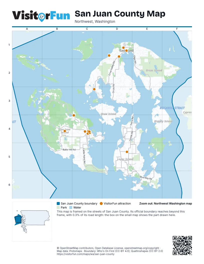
Street index of San Juan County
Each street on the sheet and the grid squares it crosses.
- Roche Harbor RoadB3, B4, C4
- Cattle Point RoadC4, C5, D5, C6, D6
- Orcas RoadD1, D2, D3
- Olga RoadE1, E2, E3
- Fisherman Bay RoadD4, D5
- West Side RoadA4, B4, B5
- Center RoadD4, E4, D5
- West Valley RoadB3, B4
- Mud Bay RoadD5, E5, E6
- Bailer Hill RoadB5, C5
- Beaverton Valley RoadB4, C4
- Mount Baker RoadD1, E1
- Ferry RoadE3, D4, E4
- Douglas RoadC4, C5
- Mitchell Bay RoadA3, A4, B4
- Terrill Beach RoadE1
- Argyle AvenueC4
- Spring StreetC4
- Guard StreetC4
- Mullis StreetC4
- Lover's LaneD1
- Harrison StreetC4
- Little RoadC5
- Tucker AvenueC4
- Ferry Waiting LaneD3
- Second Street SouthC4
- 2nd StreetE3, C4
- First Street SouthC4
- Friday Harbor Ferry TerminalC4
- Front Street SouthC4
- Deer Harbor RoadC2, D2, C3, D3
- Lopez Sound RoadD5, E5
- Crow Valley RoadD1, D2
- Port Stanley RoadE4, E5
- San Juan Valley RoadB4, C4
- Pear Point RoadC4, D4
- Wold RoadB4, B5
- Davis Bay RoadD5
- Sperry RoadE5, E6
- Aleck Bay RoadE6
- Turn Point RoadC4, D4
- Shark Reef RoadD5
- Mackaye Harbor RoadE6
- Richardson RoadD5, D6
- Lopez RoadD4
- Airport RoadC1, D5
- Vista RoadD6, E6
- Hummel Lake RoadD4, E4
- Cross RoadD4, E4
- School RoadD1, D5, E5
- Dill RoadD5
- Golf Course RoadC5
- Boyce RoadB4
- Crescent Beach DriveD1, E1
- Hodgson RoadD6
- Military RoadD4
- Kjargaard RoadD5
- Burt RoadD5
- Main StreetD1
- Weeks RoadD4
- Village RoadD4
- A StreetD1, C4
- Nichols StreetC4
- Washburn PlaceD4
- Lopez Road NorthD4
- Spencer RoadE3, E4, F4
- Dolphin Bay RoadD2, D3
- Mount Constitution RoadE2
- Point Lawrence RoadE2, F2, E3
- Channel RoadC2, C3, D5
- Mount Pickett RoadE2, F2
- Buck Mountain RoadE1
- False Bay DriveC5
- Raccoon Point RoadE1
- Enchanted Forest RoadD1
- Neck Point RoadC3, D3
- Killebrew Lake RoadD3
- Mount Dallas RoadB4, B5
- Obstruction Pass RoadE3
- Bakerview RoadE4, E5
- Blind Bay RoadD3
- Spring Point RoadC2, C3
- Rosario RoadE2
- Yacht Haven RoadA3, B3
- Egg Lake RoadB3, B4
- Twin Lakes DriveE1
- Bayshore RoadD4, B5, D5
- Thatcher Pass RoadE4, F4, E5
- White Point RoadA3, B3
- Cowlitz Bay - Waldron Center RoadC1
- Three Corner Lake RoadB3, B4
- Smugglers Cove RoadD3, A4
- Ben Nevis Loop RoadD3
- Day Lake RoadE1
- Lawson RoadB4
- Squaw Bay RoadD3, D4
- Reed Shipyard RoadE5
- Cady Mountain RoadB4
- Foster Point RoadD3, E3
- Three Meadows LaneB4, C4
- White Beach RoadD3, E3
- Forest LaneF2, E4
- Watmough Head RoadE6
- San Juan DriveB3
- Cormorant Bay RoadC2
- Eagle Ridge RoadE1, E2
- Spring Hill RoadD2
- Mountain Crest DriveD2
- Mount Woolard RoadD2, D3
- Chinook WayC4, E5
- Hoffman Cove RoadD3, D4
- Paradise RoadC5, D5, D6
- Midway RoadD3, D4
- Tarte RoadB3
- Kanaka Bay RoadB5
- Pioneer Hill RoadE2, E3
- Islandale RoadE5, E6
- Cousins RoadD5, E5, E6
- Timber LaneD1, B4
- Vusario LaneE2
- Victorian Valley DriveD3
- Terrace DriveC4
- Palisades DriveE2
- Circle RoadC3
- North Beach RoadD1
- Livesey LaneE2, E3
- Kahboo Hill RoadE2
- Sandwith RoadB4
- Elliott RoadE5
- Peninsula RoadD4, D5, E5
- West Beach RoadD1, D2
- Old Farm RoadD3, C5
- Pavey BoulevardE6
- Valley Farms RoadB4, B5
- Tibbs RoadC3, D3
- Outward Bound RoadF2
- Shooting Star LaneD2, D3, B4
- Sunderland RoadD2
- Discovery WayE2
- Shoreland DriveE4
- Deep Meadow LaneC2
- Gratzer RoadD3
- Eagle Lake LaneF2
- Decatur Head DriveE5, F5
- Lampard RoadC4
- Richard Lee LaneB4
- Fallingreen WayB4, C4
- No 2 School House RoadC4
- Old Johnson RoadwayC5
- Miller RoadB4
- Tomihi DriveE2
- Treeline DriveC5
- Aerie DriveB4, B5
- Guthrie Cove RoadD3, E3
- Kiya WayB4
- Beatrice LaneD2, E2, E3
- Deer Point RoadE3
- Lovers Cove RoadC2, D2
- Flint RoadE6
- Afterglow DriveB3
- Prohaska RoadB4
- Rouleau RoadB3
- Cole RoadE6
- Red Cross Quarry RoadD2
- Bullfrog RoadB4, B5
- Shoreline LaneC3, C4
- University RoadC4
- Grindstone Harbor RoadD3
- Mountain RoadC1
- Seduiml Hill RoadD3
- Portland Fair RoadC5
- Diamond Hill RoadE3
- Cedar Hill RoadD1
- Sawmill RoadC2
- Decatur Highland RoadE4, E5
- Harmon Ranch RoadE5
- Englehartson RoadD1, D2
- Swan RoadD2
- Bartel RoadD1, E1
- Northwest Thatcher Pass RoadE4
- Misty Isle DriveB3, C3
- Cherry Tree LaneD4, D5
- Eastman RoadD2
- Laporte RoadD3
- Bar Nothin Ranch RoadC4, D4
- Evergreen WayE3
- Victoria DriveB5
- Hannah RoadB5
- Trailhead RoadE3
- Eureka DriveC4
- Marine DriveE3
- Hidden Ridge TrailE1, E2
- Slanted Apple LaneD3
- Seth RoadE6
- Hawkins RoadD2
- Parks Bay DriveC3, C4
- Armadale RoadA3, B3
- Stehekin WayB4, B5
- Pleasure Horse RoadD2
- Wright RoadE1
- Cape DriveD5
- Petrich RoadB3
- Shaner-Armstrong LaneD2, E2
- Wildrose LaneC2, D2, D5
- Sunrise Ridge RoadB3
- Rebe RoadE3
- Julie RoadB4
- Westcott DriveB3
- Ridgedale RoadC4
- Raven Ridge RoadB4
- Limestone Point RoadB3
- Boundary Point RoadB3, C3
- Indian Cove RoadD4
- Capron RoadB4
- Marilee LaneD1
- Long LaneD4, E4
- Mount Entrance RoadE2, E3
- Roehl's Hill RoadE2, F2
- Fauntleroy Point DriveE4, F4
- Beach Haven RoadD1
- Nelson TrailA3
- Whiskey Hill RoadD5
- Big Foot RoadC4
- Evergreen LaneB5
- Jensen Bay RoadC5
- Osprey LaneD2
- Buckhorn RoadE1
- Wild Rose Ranch LaneB4, C4
- Byron RoadB3
- Gravel Pit RoadC1, D2
- Lookout LoopD1
- Blazing Tree RoadB3
- Blue Heron LaneD2, D3
- Harborview LaneC3
- Cape Saint Mary RoadE6
- Pickett's LaneE2, F2
- Halvorsen RoadC4
- Carousel RoadC3
- Carefree WayA4, B4
- Little Mountain RoadB5
- Bowers RoadE5, F5
- Hunter Bay RoadE5
- Bluebell Springs RoadE1
- Clam Harbor RoadD2, D3
- High Haro DriveB4
- Tralnes RoadE6
- Darwin TrailD3
- Heron LaneA3, B3, C3, D5
- Eliza LaneE6
- Telegraph LaneC5
- Gibson RoadD1
- Spirit RoadE5
- Brown IslandC4
- Rue GilsonD3, D4
- Highlands DriveE2, B3
- Old Sentinel RoadF2
- Rosler RoadC5
- Pinneo RoadD2
- Pine Ridge DriveE3
- Double Cove RoadD3
- Mineral Point RoadB3
- Darvill Farm RoadD1
- Mail Bay RoadC1
- Bonanza DriveE5
- Blanchard RoadD1
- Cottonwood RoadB5
- Williams LaneD4, D5
- Hooterville LaneE5
- Snowberry LaneD1, C4, C5, E6
- Longwood LaneE1
- Redoubt RoadC5
- Eagle Cove DriveC5
- Shawdow RoadE2
- Rustic Homestead LaneD3
- Marcotte DriveB3
- Minnow Creek LaneD2
- Mac Ginitie RoadB5
- Fitch RoadB4
- Dirt DriveE6
- Helen Loggie LaneE1
- Indian Point RoadC2
- Newton Beach RoadD3
- Kurth RoadD2
- Primrose LaneB3, C3
- Sutton RoadC4
- Bear Cove RoadC3
- Nordstroms LaneD2
- Cessna AvenueB3
- Hidden Meadows LaneB4
- Calendar DriveE1
- Purdue Lake RoadE1
- Lois LaneD2, E2
- Broken Point RoadD3
- Shady LaneD1, B4, D4
- Boddington LaneD2
- Dexter LaneB4
- Serendipity LaneC3, D3
- Doris RoadD5
- Nelson LaneD3, D4
- Dancing Deer DriveC2
Things to do on the San Juan County map
Places on the map
- Active Cove
- Aleck Bay
- Barlow Bay
- Beaverton Marsh
- Beaverton Marsh Preserve
- Blakely Island Airport
- Blakely Preserve
- Blind Bay
- Boundary Pass
- Briggs Lake
- Brown Island
- Buoy Bay
- Cady Mountain Preserve
- Camp Nor'Wester
- Camp Orkila
- Cascade Bay
- Cascade Lake
- Cayou Channel
- Center Island
- Charles Island
- Clark Island
- Clark Island Marine State Park
- Cowlitz Bay
- Crane Island
- Crescent Beach Preserve
- Davis Bay
- Deer Harbor
- Deer Harbor/DHB Seaplane Base
- Doe Bay
- Dream Lake
- East Sound
- Echo Bay
- False Bay
- Lopez Island Wildlife Area
- Moran State Park
- San Juan Islands National Wildlife Refuge
- Stuart Island Airpark - 7WA5
- Sucia Island Marine State Park
- Turtleback Mountain Preserve
- Waldron Airstrip
© OpenStreetMap contributors, Open Database License, openstreetmap.org/copyright · Map data: Protomaps · Boundary: Who's On First (CC-BY 4.0); Quattroshapes (CC BY 2.0)















