

Washington map
Spokane map
About 230,609 people live here (Census Bureau, 2024 estimate). The sheet's index lists 267 streets; South Rockwood Boulevard, South Hatch Road and North Nevada Street cross the most grid squares. Things to do inside the boundary: Northwest Museum of Arts and Culture and Wonders of the World.
Open the map (PDF, US Letter)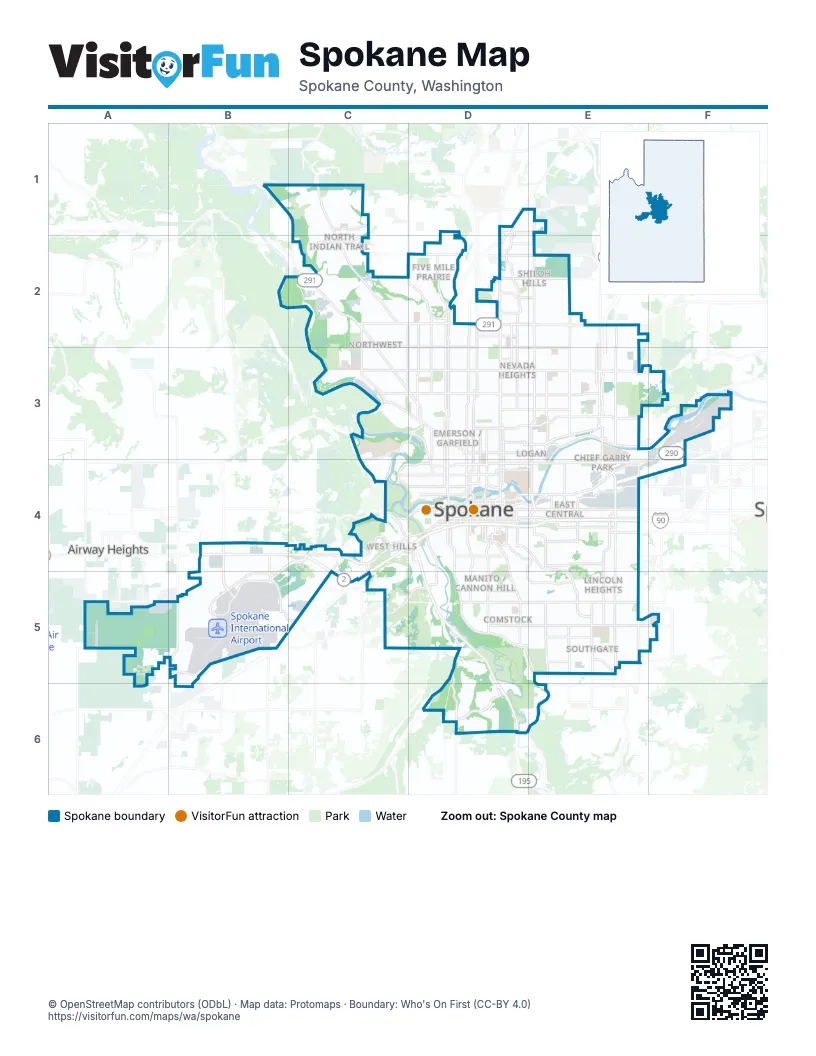
Street index of Spokane
Each street on the sheet and the grid squares it crosses.
- North Nine Mile RoadB1
- North Indian Trail RoadC1, C2
- West Shawnee AvenueC1
- East Hoerner StreetD1, D2
- East Holland AvenueD1, E1
- North Newport HighwayD1, D2
- East Hawthorne RoadE1
- North Nevada StreetE1, E2, E3
- Assembly StreetC2
- North A StreetC2, C3, D3
- North Assembly StreetC2, C3
- North Barnes RoadC2
- North Driscoll BoulevardC2, C3, D3
- West Barnes RoadC2
- West Francis AvenueC2, D2
- West Indian Trail RoadC2
- West Nine Mile RoadC2
- West Rowan AvenueC2, D2
- West Strong RoadC2, D2
- East Addison DriveD2
- East Central AvenueD2
- East Cozza DriveD2, E2
- East Francis AvenueD2, E2
- East Jay AvenueD2
- East Lincoln RoadD2, E2
- East Lyons AvenueD2
- East Magnesium RoadD2, E2
- North Addison StreetD2, D3
- North Alberta StreetD2, D3
- North Ash StreetD2, D3, D4
- North Austin RoadD2
- North Belt StreetD2, D3, D4
- North Cedar RoadD2
- North Colton PlaceD2
- North Colton StreetD2
- North Country Homes BoulevardD2
- North Division StreetD2, D3, D4
- North Five Mile RoadD2
- North Lidgerwood StreetD2, D3
- North Maple StreetD2, D3, D4
- North Monroe StreetD2, D3, D4
- North Standard StreetD2
- North Wall StreetD2, D3, D4
- West Cascade WayD2
- West Central AvenueD2
- West Five Mile RoadD2
- West Lyons AvenueD2
- North Crestline StreetE2, E3
- North Freya StreetE2, E3, E4
- North Haven StreetE2, E3, E4
- North Market StreetE2, E3
- North Spokane CorridorE2, E3
- West Garland AvenueC3, D3
- West Government WayC3, C4
- West Northwest BoulevardC3, D3
- West Wellesley AvenueC3, D3
- West Whistalks WayC3, D3, C4
- East Bridgeport AvenueD3, E3
- East Empire AvenueD3, E3
- East Glass AvenueD3
- East Illinois AvenueD3, E3
- East Indiana AvenueD3, E3
- East Montgomery AvenueD3
- East North Foothills DriveD3, E3
- East Queen AvenueD3
- East Rowan AvenueD3, E3
- East Wellesley AvenueD3, E3
- North Cochran StreetD3
- North Dakota StreetD3
- North Howard StreetD3, D4
- North Pettit DriveD3, D4
- North Post StreetD3, D4
- North Ruby StreetD3, D4
- North T J Meenach DriveD3
- North Washington StreetD3, D4
- West Augusta AvenueD3
- West Buckeye AvenueD3
- West Downriver DriveD3
- West Glass AvenueD3
- West Indiana AvenueD3
- West Providence AvenueD3
- West T J Meenach DriveD3
- West Walton AvenueD3
- East Carlisle AvenueE3
- East Ermina AvenueE3
- East Euclid AvenueE3
- East Frederick AvenueE3
- East Garland AvenueE3
- East Grace AvenueE3
- East Upriver DriveE3, F3
- East Valley Springs RoadE3, F3
- North Greene StreetE3, E4
- North Hamilton StreetE3, E4
- North Haven PlaceE3
- North North Center StreetE3
- North Perry PlaceE3
- North Perry StreetE3, E4
- North Ralph StreetE3
- East Rutter AvenueF3
- East Trent AvenueF3, E4, F4
- North Fancher RoadF3, F4
- North Park RoadF3
- South Flint RoadB4, B5
- West Airport DriveB4, C4, B5
- West Sunset HighwayB4, C4
- North Summit BoulevardC4
- South Assembly RoadC4
- South Geiger BoulevardC4, B5, C5
- South Government WayC4, D4
- South Grove RoadC4
- South Rustle RoadC4
- South West DriveC4
- South Westcliff PlaceC4
- West 13th AvenueC4, D4
- West Boone AvenueC4, D4
- West Broadway AvenueC4, D4
- West Deska DriveC4
- West Garden Springs RoadC4, C5
- West Riverside AvenueC4, D4
- West Rosamond AvenueC4
- West Summit BoulevardC4, D4
- West Sunset BoulevardC4, D4
- West West DriveC4
- East 10th AvenueD4
- East 14th AvenueD4
- East 2nd AvenueD4, E4
- East 3rd AvenueD4, E4
- East 4th AvenueD4, E4
- East 5th AvenueD4, E4
- East Main AvenueD4
- East Martin Luther King Jr. WayD4, E4
- East Mission AvenueD4, E4
- East Rockwood BoulevardD4, E4, E5
- East Sharp AvenueD4, E4
- East Spokane Falls BoulevardD4, E4
- East Sprague AvenueD4, E4
- North Adams StreetD4
- North Atlantic StreetD4
- North Bernard StreetD4
- North Browne StreetD4
- North Jefferson StreetD4
- North Lincoln StreetD4
- North Pine StreetD4
- North Riverpoint BoulevardD4
- North Sherman StreetD4
- North Stevens StreetD4
- Pettit DriveD4
- South Bernard StreetD4, D5
- South Browne StreetD4
- South Cannon StreetD4
- South Cedar StreetD4, D5
- South Cowley StreetD4
- South Division StreetD4
- South Grand BoulevardD4, D5
- South Grove StreetD4
- South Howard StreetD4
- South Inland Empire WayD4, D5
- South Jefferson StreetD4
- South Lincoln StreetD4, D5
- South Lindeke StreetD4
- South Maple StreetD4
- South McClellan StreetD4
- South Monroe StreetD4
- South Post StreetD4
- South Rockwood BoulevardD4, E4, D5, E5
- South Sherman StreetD4
- South Southeast BoulevardD4, E4, E5
- South Sprague WayD4, E4
- South Stevens StreetD4
- South Sunset BoulevardD4
- South Wall StreetD4
- South Walnut PlaceD4
- South Walnut StreetD4
- South Washington StreetD4
- Spokane Falls BoulevardD4
- West 14th AvenueD4
- West 16th AvenueD4
- West 1st AvenueD4
- West 2nd AvenueD4
- West 3rd AvenueD4
- West 4th AvenueD4
- West 5th AvenueD4
- West 6th AvenueD4
- West 7th AvenueD4
- West 8th AvenueD4
- West 9th AvenueD4
- West Freeway AvenueD4
- West Main AvenueD4
- West Mallon AvenueD4
- West Maxwell AvenueD4
- West Mission AvenueD4
- West North River DriveD4
- West Pacific AvenueD4
- West Rockwood BoulevardD4
- West Spokane Falls BoulevardD4
- West Sprague AvenueD4
- West Summit ParkwayD4
- East 17th AvenueE4
- East 18th AvenueE4
- East 8th AvenueE4
- East 9th AvenueE4
- East Alki AvenueE4
- East Alki WayE4
- East Broadway AvenueE4
- East Ferry AvenueE4
- East Hartson AvenueE4
- East Liberty Park PlaceE4
- East Newark AvenueE4
- East North Altamont BoulevardE4
- East Olive AvenueE4
- East Southeast BoulevardE4, E5
- North Altamont StreetE4
- North Fiske StreetE4
- North Freya WayE4
- North Havana StreetE4
- North Helena StreetE4
- North Napa StreetE4
- North Sprague WayE4
- Ray PlaceE4
- South Altamont StreetE4
- South Arthur StreetE4
- South Freya StreetE4, E5
- South Havana StreetE4, E5
- South Helena StreetE4
- South Madelia StreetE4
- South Napa StreetE4
- South Perry StreetE4, E5, E6
- South Pittsburg StreetE4
- South Ray StreetE4, E5
- South Thor PlaceE4
- South Thor StreetE4
- West McFarlane RoadA5
- Flightline BoulevardB5, C5
- South Hayford RoadB5
- South Spotted RoadB5
- West 53rd AvenueB5
- West Electric AvenueB5
- West Electric RoadB5
- South Garden Springs RoadC5
- West Lawton RoadC5
- West Thorpe RoadC5, D5
- East 25th AvenueD5
- East 29th AvenueD5, E5
- East 37th AvenueD5, E5, F5
- East High DriveD5
- High Drive ParkwayD5
- South Cedar RoadD5, D6
- South Cheney-Spokane RoadD5, D6
- South Hatch RoadD5, E5, D6, E6
- South High DriveD5
- South Scott StreetD5
- South Thorpe RoadD5
- West 23rd AvenueD5
- West 25th AvenueD5
- West 29th AvenueD5
- West 37th AvenueD5
- West High DriveD5
- East 44th AvenueE5
- East 49th AvenueE5
- East Thurston AvenueE5
- South Crestline StreetE5
- South Palouse HighwayE5
- South Regal StreetE5
- South Hangman Valley RoadD6
- South Meadow Lane RoadD6
- West Eagle Ridge BoulevardD6
- East 57th AvenueE6
Things to do on the Spokane map
Places on the map
- A & J Brokerage & Pallet Co
- A.M. Cannon Park
- ABC Mini-Storage
- Adams Elementary School
- Adirondack Lodge
- Adirondack Village
- All Saints Middle School
- Andrew Rypien Field
- Arlington Elementary School
- Ashburn Village
- Ashland Conservation Futures
- Audubon / Downriver
- Audubon Elementary School
- Audubon Park
- Austin Ravine Conservation Area
- Auto Credit Sales
- Avista Corporation
- Balboa / South Indian Trail
- Balboa Elementary School
- Beacon Hill Addition
- Beacon Hill Catering & Events
- Bemiss
- Ben Burr Park
- Biltmore Apartments
- Birkdale
- Blackwood
- Bluegrass
- Bowl and Pitcher Campground
- Bridlewood
- Browne Elementary School
- Browne's Addition
- Camp Chevrolet and Cadillac
- Campion Park
- Cannon Hill Park
- Canyon Bluffs
- Canyon Greens Apartments
- Carillon Place
- Casa Bella
- Cascade Manufactured Home Community
- Cedar Creek Village
Next to Spokane
- Airway Heights
© OpenStreetMap contributors (ODbL) · Map data: Protomaps · Boundary: Who's On First (CC-BY 4.0)