

Washington map
Tacoma map
About 228,202 people live here (Census Bureau, 2024 estimate). The sheet's index lists 238 streets; Norpoint Way Northeast, Marine View Drive and 6th Avenue cross the most grid squares. Things to do inside the boundary: LeMay - America's Car Museum, Museum of Glass and Tacoma Glassblowing Studio.
Open the map (PDF, US Letter)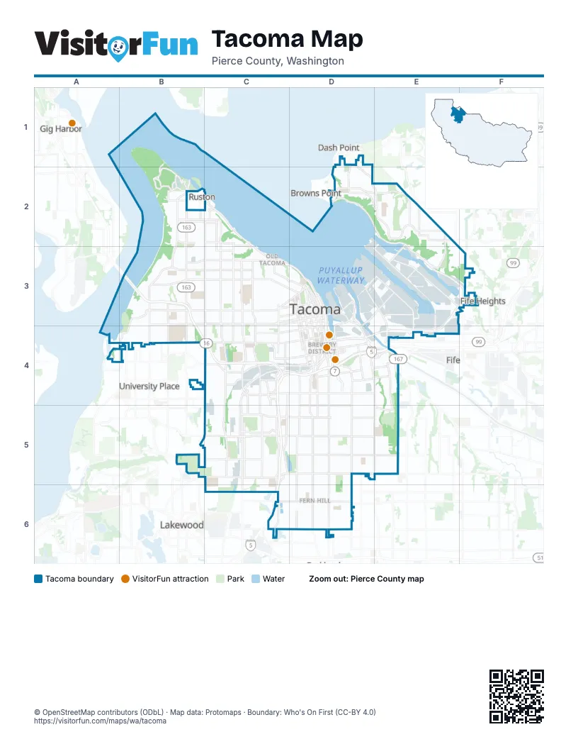
Street index of Tacoma
Each street on the sheet and the grid squares it crosses.
- North Owen Beach RoadB1, B2
- 21st Avenue NortheastD1
- Browns Point BoulevardD1, D2
- Norpoint Way NortheastD1, D2, E2, E3
- Animal Loop RoadB2
- Boat LaunchB2
- Ferry Waiting LanesB2
- Five Mile DriveB2
- Five Mile Extension DriveB2
- Fort Nisqually Bypass DriveB2
- Mildred St Exit RoadB2
- North 37th StreetB2, C2
- North 45th StreetB2, C2
- North 46th StreetB2, C2
- North 51st StreetB2
- North Baltimore StreetB2
- North Mildred StreetB2, B3
- North Narrows DriveB2, B3
- North Park WayB2
- North Pearl StreetB2, B3
- North Vassault StreetB2
- Wilderness Cut Off 1B2
- Wilderness Cut Off 2B2
- Wilderness Cut Off2B2
- Zoo Parking LoopB2
- Island View AvenueC2
- North 36th StreetC2
- North 49th StreetC2
- North Alder WayC2, C3
- North Cheyenne StreetC2, C3
- North Ferdinand StreetC2
- North Lawrence StreetC2, C3
- North Orchard StreetC2, C3
- North Proctor StreetC2, C3
- North Stevens StreetC2, C3
- North Waterview StreetC2
- Ruston WayC2, C3
- 51st Street NortheastD2
- Browns Point Boulevard NortheastD2, E2
- East Side Drive NortheastD2
- Marine View DriveD2, E2, E3, F3
- Northshore ParkwayD2, E2
- Slayden RoadD2
- Slayden Road NortheastD2
- 29th Street NortheastE2
- 31st Street NortheastE2
- 39th Avenue SouthwestE2
- 45th Avenue NortheastE2
- 49th Avenue NortheastE2
- 53rd Avenue NortheastE2
- East 11th StreetE2, D3, E3
- Southwest 356th StreetE2
- 6th AvenueB3, C3, D3, B4
- Bantz BoulevardB3
- North 17th StreetB3
- North 21st StreetB3, C3
- North 26th StreetB3, C3
- North 30th StreetB3, C3, D3
- North 9th StreetB3
- North Jackson AvenueB3
- South 12th StreetB3, C3, D3
- South Jackson AvenueB3, B4
- South Mildred StreetB3, B4
- South Pearl StreetB3, B4
- Tacoma Narrows BridgeB3
- Westgate BoulevardB3
- Division AvenueC3, D3
- Earnest S Brazill StreetC3, D3
- McCarver StreetC3
- North 34th StreetC3
- North Alder StreetC3
- North I StreetC3, D3
- North Schuster ParkwayC3, D3
- North Schuster Parkway RampC3, D3
- North Sprague AvenueC3
- North Tacoma AvenueC3, D3
- North Union AvenueC3
- South 11th StreetC3, D3
- South 9th StreetC3, D3
- South Alder StreetC3
- South Cedar StreetC3, C4
- South Orchard StreetC3, C4, C5
- South Proctor StreetC3, C4
- South Sprague AvenueC3, C4
- South Stevens StreetC3, C4
- South Union AvenueC3, C4
- A StreetD3, D4
- BroadwayD3
- Commerce StreetD3, D4
- Dock StreetD3, D4
- East 15th StreetD3, D4
- East Alexander AvenueD3, E3
- East Portland AvenueD3, D4, E4, E5
- Lincoln AvenueD3, E3, D4
- Market StreetD3, D4
- Martin Luther King Jr WayD3, D4
- Milwaukee WayD3, E3, E4
- North 1st StreetD3
- North E StreetD3
- Pacific AvenueD3, D4, D5, D6
- Saint Helens AvenueD3
- Saint Paul AvenueD3
- South 10th StreetD3
- South 13th StreetD3
- South 14th StreetD3
- South 4th StreetD3
- South 7th StreetD3
- South 8th StreetD3
- South I StreetD3
- South J StreetD3, D4
- South Schuster ParkwayD3
- South Stadium WayD3
- South Yakima AvenueD3, D4, D5, D6
- Tacoma Avenue SouthD3, D4
- Alexander Avenue EastE3, E4
- Marshall AvenueE3
- Port of Tacoma RoadE3, E4
- State Route 167E3, E4
- Taylor WayE3
- Taylor Way EastE3
- 27th Street WestA4
- Day Island Bridge Road WestA4
- Lemons Beach Road WestA4
- South 19th StreetA4, B4, C4, D4
- 19th Street WestB4
- 70th Avenue WestB4
- Alameda AvenueB4
- Bridgeport Way WestB4
- Columbia AvenueB4
- Elwood Drive WestB4
- Mildred Street WestB4
- South Walters RoadB4
- Center StreetC4, D4
- South 15th StreetC4, D4
- South 25th StreetC4, D4
- South 35th StreetC4
- South 36th StreetC4
- South 37th StreetC4
- South 38th StreetC4, D4
- South Alaska StreetC4, C5
- South Pine StreetC4, C5
- South State StreetC4
- South Steele StreetC4, C5, C6
- South Tacoma WayC4, D4, C5, C6
- South Trafton StreetC4
- South Tyler StreetC4, C5
- South Warner StreetC4, C5
- South Washington StreetC4, C5
- South Wilkeson StreetC4
- Sprague RampC4
- State Route 16C4
- Tacoma Mall BoulevardC4, C5, C6
- Bay StreetD4, E4
- Delin StreetD4
- East 25th StreetD4
- East 26th StreetD4
- East 27th StreetD4, E4
- East 28th StreetD4, E4
- East 30th StreetD4, E4
- East 34th StreetD4, E4
- East 38th StreetD4, E4
- East D StreetD4
- East Division LaneD4
- East Fairbanks StreetD4, E4
- East G StreetD4
- East L StreetD4
- East Q StreetD4
- Jefferson AvenueD4
- McKinley AvenueD4, D5, D6
- McKinley WayD4
- Puyallup AvenueD4
- South 17th StreetD4
- South 21st StreetD4
- South 24th StreetD4
- South 26th StreetD4
- South 27th StreetD4
- South 28th StreetD4
- South 34th StreetD4
- South C StreetD4
- South G StreetD4, D5
- South Hood StreetD4
- South J StD4
- South M StreetD4, D5
- South Thompson AvenueD4, D5
- Wiley AvenueD4
- 12th Street EastE4
- East 29th StreetE4
- East Grandview AvenueE4
- East R StreetE4
- East Roosevelt AvenueE4, E5
- East S StreetE4
- East Wright AvenueE4
- North Frontage RoadE4
- Pioneer WayE4
- Pioneer Way EastE4
- River RoadE4
- River Road EastE4
- Lakewood Drive WestB5
- 66th Street WestC5
- 74th Street WestC5
- Cirque Drive WestC5
- Orchard Street WestC5
- Railroad StreetC5
- South 47th StreetC5
- South 48th StreetC5, D5
- South 50th StreetC5
- South 54th StreetC5
- South 56th StreetC5, D5
- South 58th StreetC5
- South 66th StreetC5
- South 72nd StreetC5, D5
- South 74th StreetC5
- South Hosmer StreetC5, C6
- South Oakes StreetC5
- South Puget Sound AvenueC5
- South Railroad StreetC5
- East 43rd StreetD5
- East 48th StreetD5, E5
- East 56th StreetD5, E5
- East 64th StreetD5, E5
- East 72nd StreetD5, E5
- South 43rd StreetD5
- South 64th StreetD5
- South Sheridan AvenueD5, D6
- Thomp Yakim TransD5
- 64th Street EastE5
- East 44th StreetE5
- Steele Street SouthC6
- 85th Street EastD6
- 96th Street EastD6
- 96th Street SouthD6
- 99th Street EastD6
- 99th Street SouthD6
- East 84th StreetD6
- Pacific Avenue SouthD6
- South 84th StreetD6
- South 96th StreetD6
- Yakima Avenue SouthD6
Things to do on the Tacoma map
Places on the map
- 6th Avenue Plaza
- 72nd Street Square
- Alaska Street Reservoir
- Alderwood Park
- Alexander Avenue Wetland
- Allenmore Golf Course
- Allenmore Ridge
- Annie Wright School
- Baker Middle School
- Bass Pro Shops
- Bellarmine Preparatory School
- Bethlehem Baptist Church
- Birney Elementary School
- Blix Elementary School
- Blue Bird Apartments
- Boulevard Center
- Boze Elementary School
- Breakwater Marina
- Browns Point Athletic Complex
- Browns Point Elementary School
- Calvary Cemetery
- Catherine Ursich Park
- Central Wastewater Treatment Plant
- Champions Centre
- Charlotte's Blueberry Park
- Cheney Stadium
- Cherry Creek Apartments
- China Lake Park
- Chinese Reconciliation Park
- Commencement Bay
- Concordia Christian Academy
- Concrete Tech
- Costco
- Cummings Park
- DeLong Park
- Dickman Mill Park
- Dixon Village
- Downing Elementary School
Next to Tacoma
- Browns Point
- Dash Point
- Federal Way
- Fife
- Fife Heights
- Gig Harbor
- Lakewood
- Ruston
- University Place
© OpenStreetMap contributors (ODbL) · Map data: Protomaps · Boundary: Who's On First (CC-BY 4.0)