

Washington map
Washougal map
About 17,944 people live here (Census Bureau, 2024 estimate). The sheet's index lists 267 streets; Lewis and Clark Highway, B Street and G Street cross the most grid squares. Also on it: Captain William Clark Park, Orchard Hills Golf Course and Cottonwood Beach.
Open the map (PDF, US Letter)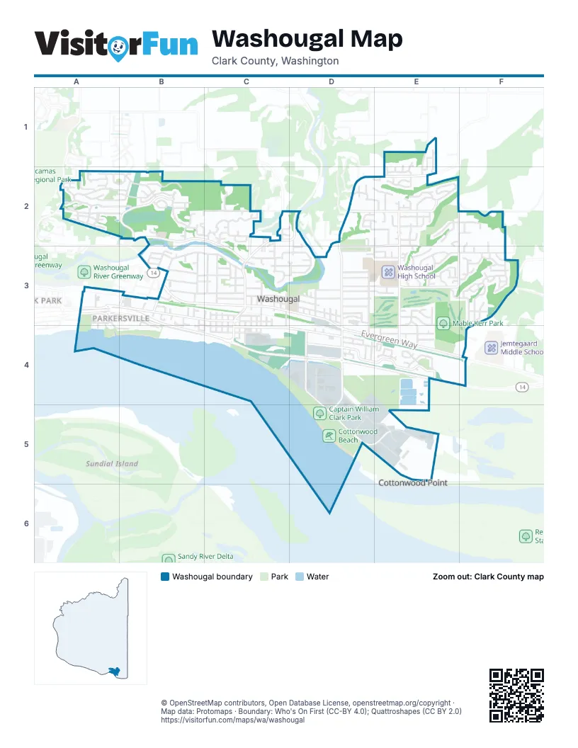
Street index of Washougal
Each street on the sheet and the grid squares it crosses.
- 37th CourtE1, E2
- 39th CourtE1, E2
- 41st CourtE1, E2, E3, E4
- 44th StreetE1, E2
- 45th StreetE1, E2, E4
- Fir StreetE1
- Forest View DriveE1, E2
- Southeast Lehr RoadE1, E2
- West 10th StreetA2
- West 11th StreetA2
- West 2nd StreetA2, B2
- West 5th StreetA2
- West 6th StreetA2
- West 7th StreetA2
- West 8th CourtA2
- West 8th StreetA2
- West 9th StreetA2
- West Alder CourtA2
- West Alder StreetA2
- West Bamboo CourtA2
- West Bamboo StreetA2
- West Chestnut StreetA2
- West Dogwood CourtA2
- West Dogwood StreetA2, B2
- West Lookout Ridge DriveA2, B2
- West S CircleA2
- West S StreetA2
- West T StreetA2
- West U StreetA2, B2
- West V StreetA2
- West W StreetA2, B2
- West X CircleA2, B2
- West X StreetA2
- West Y StreetA2, B2
- West Z StreetA2
- North 3rd StreetB2
- North 4th CourtB2
- North 4th StreetB2
- North 6th StreetB2
- North 7th StreetB2
- North 8th StreetB2
- North 9th StreetB2
- North Dogwood CourtB2
- North Lebrun DriveB2
- North P CourtB2
- North P StreetB2, C2, C3
- North Q StreetB2, C2, C3
- North R StreetB2, C2, D2
- North Shepherd RoadB2, C2, C3
- North Stonegate DriveB2
- North T StreetB2, C2
- North U StreetB2
- North V StreetB2
- North X CourtB2
- North X StreetB2
- North Y StreetB2
- West 1st StreetB2
- West Empress StreetB2
- North 10th CourtC2
- North 10th StreetC2
- North 11 DriveC2
- North 12th StreetC2
- North 14th StreetC2
- North 15th CourtC2
- North 15th StreetC2
- North 17th StreetC2
- North 18th CircleC2
- North 18th CourtC2
- North 18th StreetC2, C3
- North 20th PlaceC2, C3
- North 20th StreetC2, C3
- North 21st PlaceC2, C3
- North 23rd StreetC2
- North 24th CourtC2, D3
- North Blodgett CourtC2
- North Columbia Ridge WayC2
- North P CircleC2, D2, D3
- North Q CircleC2
- North S StreetC2, D2
- North Washougal River RoadC2, D2, C3
- North Woodburn RoadC2
- Southeast 40th StreetC2
- 33rd CourtD2
- 34th StreetD2, D3, D4
- 35th StreetD2, E3, D4
- Cedar CourtD2, E2
- North 25th StreetD2, D3
- R StreetD2, E2
- S StreetD2, E2, F2
- T StreetD2
- U StreetD2, E2, F2
- V StreetD2, E2
- W StreetD2, E2, F2
- X StreetD2, E2
- Y StreetD2, E2
- Z StreetD2, E2
- 36th StreetE2, E3, E4
- 37th StreetE2
- 38th CourtE2, E3
- 38th StreetE2
- 39th StreetE2, E3, E4
- 40th CourtE2, E4
- 40th StreetE2, E3
- 41st StreetE2
- 42nd CourtE2, E3
- 42nd StreetE2, E3, E4
- 43rd StreetE2, E3
- 48th StreetE2, E3
- 49th StreetE2, F2, E3, F3
- Birch StreetE2
- Cedar StreetE2
- Dr Eldridge DriveE2
- Elderberry StreetE2
- Q CircleE2
- Q StreetE2, D3, E3
- R CircleE2
- R DriveE2, F2, E3
- S CircleE2
- Southeast 34th StreetE2
- Southeast Lawton RoadE2
- T CircleE2
- Z CircleE2
- 50th StreetF2, F3
- 52nd CourtF2, F3
- 54th StreetF2, F3
- 57th AvenueF2, F3
- 1st StreetA3
- 2nd StreetA3
- 3rd StreetA3, B3
- C StreetA3, B3, C3, E4
- Lewis and Clark HighwayA3, B3, B4, C4, D4
- South 1st StreetA3, A4
- South 2nd StreetA3, A4, B4
- South A StreetA3, B3, B4
- South Marina WayA3, B3
- Southeast 10th AvenueA3
- Southeast 11th AvenueA3
- Southeast 8th AvenueA3
- 4th StreetB3
- 5th StreetB3
- 6th CourtB3
- 6th StreetB3
- 7th CourtB3
- 7th StreetB3
- 8th CourtB3
- 8th StreetB3, B4
- 9th StreetB3, B4, C4
- B StreetB3, B4, C4, D4, E4
- D StreetB3, C3, F3
- E StreetB3, C3, D3
- G StreetB3, C3, D3, E3, F3
- H StreetB3, C3, D3
- I StreetB3, C3, D3, E3, F3
- J StreetB3, C3, D3, E3, F3
- K StreetB3, C3, D3, E3, F3
- Northeast 3rd AvenueB3
- Northeast 4th AvenueB3
- South 6th StreetB3, B4
- South 7th StreetB3, B4
- Southeast J StreetB3
- Southeast Lechner StreetB3
- 10th StreetC3, C4
- 11th StreetC3, C4
- 12th StreetC3, C4
- 13th StreetC3, C4
- 14th StreetC3, C4
- 15th StreetC3
- 18th CourtC3
- 18th StreetC3
- 19th StreetC3, C4
- 20th StreetC3, C4
- 21st StreetC3, C4
- 22nd StreetC3, C4
- 23rd StreetC3
- 24th StreetC3, C4
- Durgan StreetC3, C4
- F StreetC3, D3, F3
- Love StreetC3, C4
- North 22nd StreetC3
- North 24th CircleC3, D3
- North L CourtC3
- North L DriveC3, D3
- North L StreetC3, D3
- North M CourtC3
- North M StreetC3, D3
- North O StreetC3, D3
- Pendleton WayC3, C4
- Washougal River RoadC3, C4
- 25th StreetD3
- 26th StreetD3
- 27th StreetD3, D4
- 28th CourtD3
- 28th StreetD3, D4
- 29th StreetD3, D4
- 30th StreetD3
- 31st StreetD3
- 32nd StreetD3, D4
- 33rd StreetD3, D4
- Evergreen WayD3, D4, E4, F4
- F PlaceD3
- G DriveD3
- H CircleD3
- L StreetD3, E3, F3
- North 24th StreetD3
- North 25th CircleD3
- North 28th StreetD3
- North N StreetD3
- P CircleD3, E3
- P StreetD3, E3, F3
- Webster LaneD3
- 43rd CourtE3, E4
- 45th CourtE3
- 47th StreetE3
- Center StreetE3, E4
- F CircleE3
- Fairway DriveE3
- Gifford PlaceE3
- K CourtE3
- Krause CourtE3
- L CircleE3
- Liedtke WayE3, E4
- M DriveE3
- M LoopE3
- M StreetE3
- McCallister PlaceE3
- P LoopE3
- Rolling Meadows DriveE3, F3
- 51st StreetF3
- 52nd StreetF3
- 53rd StreetF3
- 55th StreetF3
- 56th StreetF3
- 57th StreetF3
- L CourtF3
- M CourtF3
- N StreetF3
- O StreetF3
- Southeast Sunset View RoadF3, F4
- Southeast Wooding RoadF3
- Sunset Ridge DriveF3
- South A PlaceB4
- 21st CourtC4
- A StreetC4, D4, E4
- Front StreetC4
- Index StreetC4, D4
- Main StreetC4, D4
- South 15th StreetC4
- Addy StreetD4, E4
- Lewis LaneD4
- South 27th StreetD4
- South 28th StreetD4
- South 32nd StreetD4, D5
- South Ford StreetD4
- South Index StreetD4, D5
- South Truman StreetD4, D5, E5
- Southeast Lewis and Clark HighwayD4, E4
- A LoopE4
- Addy CircleE4
- Addy CourtE4
- Addy LoopE4
- Southeast 61st CircleF4
- Southeast Evergreen HighwayF4
- South 35th StreetD5
- South 37th StreetD5, E5
- Truman RoadD5
- South Grant StreetE5
- South Lincoln StreetE5
Places on the map
- 54-40 Brewing Company LLC
- 6th St. Storage
- Angelo Park
- AutoZone
- Bates Field
- Best Western Plus
- Bethel Community Church
- Bi-Mart
- Camas Washougal Animal Hospital
- Camas Washougal Municipal Court
- Camas-Washougal Moose Lodge 1042
- Campen Creek Park
- Campen Creek Wetland - Kerr Acquisition
- Captain William Clark Park
- Chevron
- Columbia Credit Union
- Convenient Food Mart
- Cottonwood Beach
- Elizabeth Park
- Excelsior High School
- forest moon yoga
- George Schmid Memorial Park
- Goodwill
- Hamllik Park
- Hartwood Park
- Hathaway Park
- Mable Kerr Park
- Orchard Hills Golf Course
- Parker's Landing Historic Park
- Steamboat Landing Park
- Stevenson Off Leash Dog Park
- The Crossing
- The Port
- The UPS Store
- Washougal Community Library
- Washougal High School
- Washougal Memorial Cemetery
- Washougal River Greenway
- Washougal River Natural Area
- Washougal Waterfront Park
Next to Washougal
- Cottonwood Point
- Oak Park
© OpenStreetMap contributors, Open Database License, openstreetmap.org/copyright · Map data: Protomaps · Boundary: Who's On First (CC-BY 4.0); Quattroshapes (CC BY 2.0)















