

Wisconsin map
Appleton map
About 63,145 people live here (Census Bureau, 2024 estimate). The sheet's index lists 300 streets; Tri-County Expressway, Midway Road and North Richmond Street cross the most grid squares. Things to do inside the boundary: The History Museum at the Castle.
Open the map (PDF, US Letter)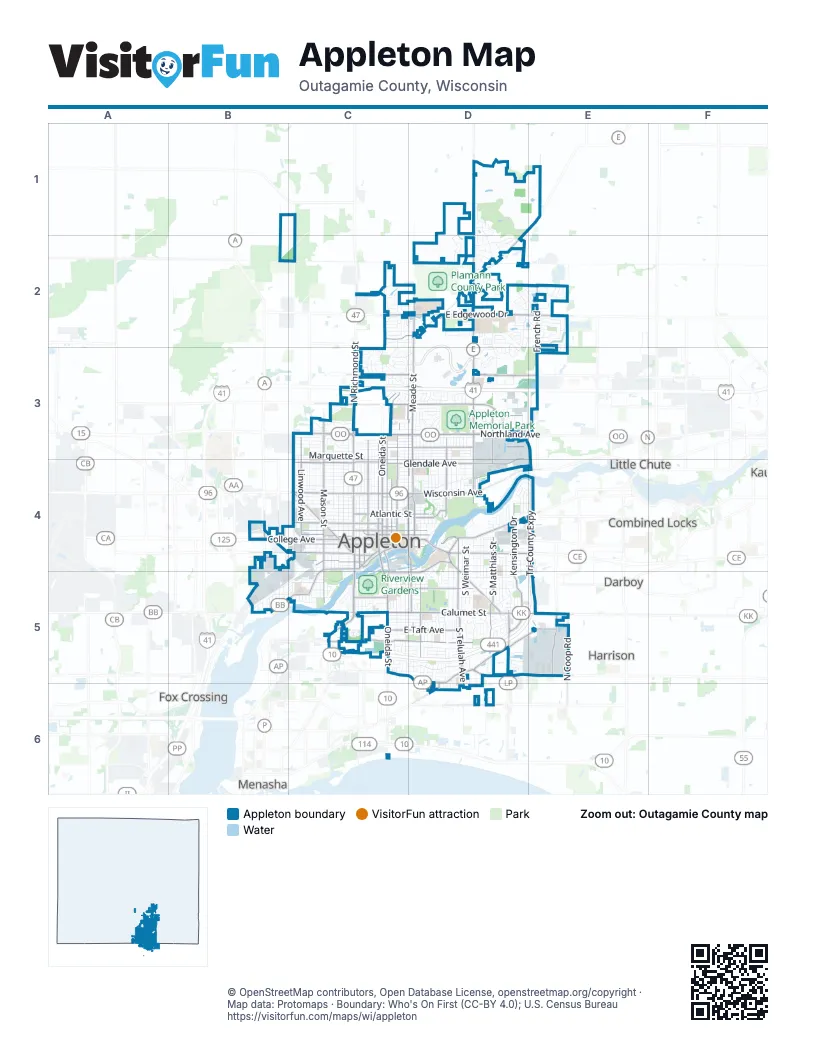
Street index of Appleton
Each street on the sheet and the grid squares it crosses.
- Tri-County ExpresswayE3, E4, C5, D5, E5
- North Richmond StreetC2, C3, C4
- West College AvenueB4, C4
- East College AvenueC4, D4, E4
- South Oneida StreetC4, C5
- South Memorial DriveC4, C5
- South Appleton StreetC4
- Appleton RoadC5
- South Oneida RoadC5
- North Ballard RoadD2, D3, D4
- North Meade StreetD2, D3, D4
- East Northland AvenueC3, D3, E3
- Midway RoadC5, D5, E5, D6
- East Calumet StreetC5, D5, E5
- East Edgewood DriveC2, D2, E2
- West Prospect AvenueC4, B5, C5
- East Wisconsin AvenueC4, D4
- North Mason StreetC3, C4
- North Morrison StreetC3, C4
- West Wisconsin AvenueC4
- West Northland AvenueC3
- East Apple Creek RoadC2, D2
- North Oneida StreetC3, C4
- East Newberry StreetD4, E4
- North Appleton StreetC3, C4
- South Lawe StreetD4, D5
- West Lawrence StreetC4
- North Lawe StreetC3, D3, D4
- North Badger AvenueC4
- South Mason StreetC4, C5
- Lake Park RoadD5
- South Lake Park RoadD5
- East Summer StreetC4, D4
- County Road ED1, E1, D2
- North Lynndale DriveB4
- South Badger AvenueC4
- West 6th StreetC4
- West Calumet StreetC5
- South Walter AvenueD4
- East Harris StreetC4
- West Main StreetD4, E4
- East Lawrence StreetC4
- West Kimberly AvenueE4
- South Morrison StreetC4
- Midway ExtendedE5
- Badger AvenueC4
- French RoadE1, E2, E3
- South Telulah AvenueD4, D5, D6
- East Glendale AvenueD3, C4, D4
- East Capitol DriveC3, D3
- North Drew StreetC3, C4
- East Plank RoadD5, E5
- East Pershing StreetC3, D3
- North Linwood AvenueC3, C4
- South Matthias StreetD4, D5
- North Division StreetC3, C4
- East John StreetD4, D5
- West Glendale AvenueC4
- North Durkee StreetC3, C4
- East Fremont StreetC5, D5
- West Spencer StreetB4, C4
- West Packard StreetC4
- East Evergreen DriveC3, D3
- South Kensington DriveD4, D5
- East Roeland AvenueC5, D5
- North Owaissa StreetD3, D4
- Eisenhower DriveE5
- South Carpenter StreetD5
- West 4th StreetB4, C4, E4
- West Franklin StreetC4
- East Taft AvenueC5, D5
- West Washington StreetC4
- East Pacific StreetC4, D4
- East South River StreetD4, C5, D5
- West College Service RoadB4, C4
- North Coop RoadE5
- North Roemer RoadD3, D4
- County Road EED1, D2
- East Washington StreetC4, D4
- East Atlantic StreetC4, D4
- East Franklin StreetC4, D4
- Valley RoadC5
- Kensington DriveD4, D5
- West Seymour StreetC5
- Manitowoc RoadD6
- North Kensington DriveD4
- South State StreetC4
- West Atlantic StreetC4
- South Olde Oneida StreetC4, C5
- West Capitol DriveC3
- Evergreen DriveD3, E3
- West Water StreetC4
- West Evergreen DriveC3
- South Walnut StreetC4
- Marcella StreetE4
- South Linwood AvenueC4
- East Water StreetC4
- South Drew StreetC4
- South Durkee StreetC4
- South Jackman StreetC4
- Chestnut LaneD6
- Plank RoadD6
- North Perkins StreetB4
- West North StreetC4
- East Meadow Grove BoulevardC5, D5
- South Kernan AvenueD4, D5, D6
- North Rankin StreetD3, D4
- North Union StreetC3, C4
- South Schaefer StreetD4, D5
- North Bennett StreetC3, C4
- North Locust StreetC3, C4
- East Frances StreetC4, D4
- North Superior StreetC3, C4
- North McDonald StreetD3, D4
- West Commercial StreetC4
- West Spring StreetC4
- West Winnebago StreetC4
- East Marquette StreetC3, D3
- East Lindbergh StreetC3, D3
- North Summit StreetC3, C4
- West Brewster StreetC4
- West Summer StreetC4
- West Marquette StreetC3
- East Sylvan AvenueC5, D5
- South Jackson StreetC5
- East Witzke BoulevardD3
- North Clark StreetC3, C4
- East Harding DriveC5, D5
- Lightning DriveD2, D3
- North Douglas StreetC3, C4
- Providence AvenueD2, D3
- South Walden AvenueD4, D5
- East Byrd StreetC3, D3
- North Haymeadow AvenueC2, C3
- East Broadway DriveD2
- West 8th StreetC4
- Schaefer CircleD5
- West Lindbergh StreetC3
- North Purdy ParkwayD1, D2
- South Weimar StreetD4, D5
- South Lee StreetD4, D5
- South Jefferson StreetC5
- North Racine StreetD3, D4
- East Forest StreetD4
- South Outagamie StreetC4, C5
- South Buchanan StreetD4, D5
- South Madison StreetC5
- East Lourdes DriveD4, D5
- East North StreetC4, D4
- West Parkway BoulevardC4
- West Grant StreetC4
- North Harriman StreetC3, C4
- North Ullman StreetD3, D4
- Apple Hill BoulevardD2
- North Smoketree PassD1, D2
- East Randall AvenueD4
- East Florida AvenueC3, D3
- South Fidelis StreetD4, D5
- South East StreetD5
- East Longview DriveC3, D3
- North Erb StreetC3, C4
- East Asbury DriveD2
- North Viola StreetD3, D4
- North Gillett StreetC3, C4
- River DriveC5
- North Briarcliff DriveD4, E4
- North Nicholas StreetC3, C4
- West 2nd StreetB4, C4
- North Conkey StreetD3
- North Outagamie StreetC3, C4
- West Pershing StreetC3
- East Mitchell AvenueC5, D5
- North State StreetC4
- North Story StreetC4
- West Harris StreetC4
- West Kamps AvenueC4
- South Lynndale DriveB5
- South Clara StreetD4, D5
- South Theodore StreetD4, D5
- South Midpark DriveD4, D5
- East Coolidge AvenueC5, D5
- South Joseph StreetD4, D5
- North Elinor StreetC3, C4
- East Rubyred DriveE2
- East Grant StreetC4, D4
- East Harrison StreetC5, D5
- North Birchwood AvenueC3, C4
- South Gladys AvenueD5
- East Hancock StreetC4, D4
- South Perkins StreetB4, B5
- South Douglas StreetC4, C5
- Cherryvale AvenueE2, E3
- West Taylor StreetC4
- Quest DriveD5, E5
- East Glenhurst LaneD3
- West Ridgeview DriveC3
- North Eugene StreetC3, C4
- North Alvin StreetC3, C4
- West 5th StreetC4
- South Arlington StreetD4, D5
- South Pierce AvenueC4, C5
- Milestone DriveD3
- East Brewster StreetC4, D4
- East McKinley StreetC5, D5
- East Service RoadC3, D3
- East Pauline StreetD4
- South Greenview StreetD5
- Baldeagle DriveD2
- East Commercial StreetC4, D4
- East Glory LaneD2, E2
- Mackville RoadD1
- West Pine StreetC5
- West Crossing Meadows LaneC3
- East Crestview DriveD4
- East 1st AvenueC3, D3
- West Frances StreetC3, C4
- East Murray AvenueC5, D5
- East Wilson AvenueC5, D5
- East Hoover AvenueC5, D5
- East Winnebago StreetC4, D4
- North Amethyst DriveD2, E2
- West Weiland AvenueC3
- South Christine StreetD4, D5
- East Amelia StreetD4
- East Maple StreetC5, D5
- Spartan DriveC2
- North Alexander StreetD3, D4
- Hillock CourtC3
- East Randall StreetC4, D4
- South Berry DriveD5
- East Woodland AvenueD4
- North Green Bay RoadD4
- North Edgewood AvenueC3, C4
- East Enterprise AvenueD3
- East Winslow AvenueD3
- North Knollwood LaneC2, C3
- East McArthur StreetC3, D3
- South Locust StreetC4, C5
- East Bona AvenueD5
- West Elsie StreetC4
- West Oklahoma StreetC4
- South Story StreetC4
- West Lorain StreetC4
- West Bell AvenueC4
- West Hawes AvenueC4
- East Greenleaf DriveD2, D3
- West Everett StreetB5
- East Henry StreetD4
- East Paris DriveE2
- North Charlotte StreetD4
- East Braeburn DriveE2
- Bellevue PlaceC2, D2
- East Rail RoadD5
- West Charles StreetB5, C5
- West Foster StreetC5
- East Park Hills DriveD5
- East Lincoln StreetC5, D5
- West Weiland LaneC3
- Homestead Drive WestC3
- East Crossing Meadows LaneC3, D3
- Ashbury DriveE2
- East Incline WayD2
- Windcross DriveC3
- East Eldorado StreetC4, D4
- North Marshall Heights AvenueC3
- South Harmon StreetD5
- South Fountain AvenueD5
- East Ashbury DriveD2, E2
- North Kurey DriveD2
- Osprey DriveD2
- West Rogers AvenueC5
- East Spring StreetC4, D4
- South Irma StreetD5
- Northbreeze DriveC3, D3
- South Horizon DriveD5
- North Helen StreetD3, D4
- Northwood DriveD3
- North Providence AvenueD2
- East Greenfield StreetC3, D3
- East Castlebury LaneC3, D3
- East Roosevelt StreetC4, D4
- West Roberts AvenueC4
- East Drake LaneD2
- East Edgemere DriveD4, E4
- North Fernmeadow DriveD4
- East Carrington LaneC2, D2
- Cloverdale Drive WestC3
- Eagle Flats ParkwayC4, D4
- East Lake Park CrossingD5
- Ramlen CourtC5
- Schindler PlaceC5
- East South Island StreetC4, D4
- Vantage DriveE5
- South Summit StreetC4
- Milis DriveE5
- East Wyndmere DriveD2
- South Driftwood LaneD5
- Timberline DriveC3, D3
- North Waterford DriveC2
- East Sunset AvenueD3
Things to do on the Appleton map
Places on the map
- Alicia Park
- Appleton East High School
- Appleton Highland Memorial Park Cemetery
- Appleton Memorial Park
- Appleton North High School
- Appleton West High School
- Appleton Yacht Club
- Arbutus Park
- Ascension Saint Elizabeth Hospital
- Ballard Pond
- Bruce B. Purdy Nature Preserve
- Calumet Village
- Canadian National Rail-Appleton Yard
- Care Partners
- Derks Park
- Edison Center
- Einstein Middle School
- Einstein Park
- Ellen Kort Peace Park
- Erb Park
- Evergreen Heights
- Faith Lutheran Church
- Fiesta Acres
- Fleet Farm
- Fox River Academy Ravine
- Historic Central
- Lawrence University
- Northeast Business Park
- Northland Mall
- Peabody Park
- Pierce Park
- Reid Municipal Golf Course
- Riverside Cemetery
- Riverview Gardens
- Saint Joseph Cemetery
- Sandy Slope Elementary School
- Telulah Park
- ThedaCare North Campus
- Youth Sport Complex
Next to Appleton
- Combined Locks
- Darboy
- Fox Crossing
- Harrison
- Kimberly
- Little Chute
- Menasha
© OpenStreetMap contributors, Open Database License, openstreetmap.org/copyright · Map data: Protomaps · Boundary: Who's On First (CC-BY 4.0); U.S. Census Bureau