

Wisconsin map
Northeast Wisconsin map
The sheet's index lists 29 highways; US 41, US 45 and I-41 cross the most grid squares. Things to do inside the boundary: Above & Beyond Children's Museum, Bay Beach Amusement Park and Bay Beach Wildlife Sanctuary. Also on it: Appleton, Clintonville and De Pere.
Open the map (PDF, US Letter)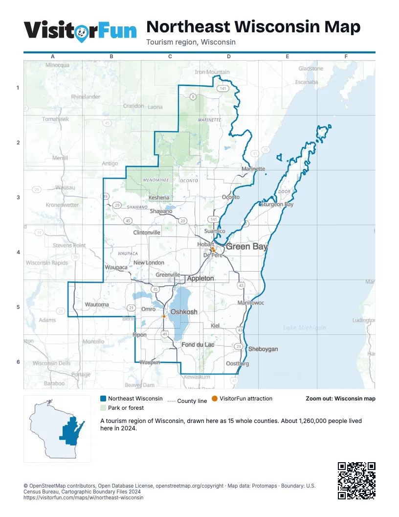
Highway index of Northeast Wisconsin
Each highway on the sheet and the grid squares it crosses.
- I-39A5
- I-41C4, C5, C6, D4
- I-43D4, D5, D6
- US 8C1, D1
- US 10B4, B5, C5, D5
- US 41C4, C5, C6, D2, D3, D4
- US 45B3, B4, C4, C5, C6
- US 51A5
- US 141D1, D2, D3, D4
- US 151C6
- WI 21A5, B5, C5
- WI 22B4, B5, C4
- WI 23C6, D6
- WI 26C6
- WI 29B3, C3, C4, D4
- WI 32C4, D4, D6
- WI 42E3
- WI 47C3
- WI 49B4, B5
- WI 52B3
- WI 54B4, D4
- WI 55C3, C4
- WI 57D3, D4, E3
- WI 73B5
- WI 110B4, B5
- WI 114C5
- WI 116C5
- WI 172D4
- WI 441C4, C5
Things to do on the Northeast Wisconsin map
- Above & Beyond Children's Museum
- Bay Beach Amusement Park
- Bay Beach Wildlife Sanctuary
- Copper Culture State Park
- EAA Aviation Museum
- Hamilton Wood Type and Printing Museum
- Hartman Creek State Park
- Heritage Hill State Historical Park
- High Cliff State Park
- John Michael Kohler Arts Center
- Kewaunee County Bruemmer Park and Zoo
- Lambeau Field
- National Railroad Museum
- Neville Public Museum of Brown County
- Newport State Park
- Paine Art Center and Gardens
- Peninsula State Park
- Potawatomi State Park
- Rock Island State Park
- The History Museum at the Castle
- Wade House Historic Site
- Whitefish Dunes State Park
- Wisconsin Maritime Museum
Places on the map
- Appleton
- Clintonville
- De Pere
- Fond du Lac
- Green Bay
- Greenville
- Hobart
- Keshena
- Kiel
- Manitowoc
- Marinette
- New London
- Oconto
- Omro
- Oostburg
- Oshkosh
- Ripon
- Shawano
- Sheboygan
- Sturgeon Bay
- Suamico
- Waupaca
- Waupun
- Wautoma
Next to Northeast Wisconsin
- Central Upper Peninsula
- North Central Wisconsin map
- South Central Wisconsin map
- Southeast Wisconsin map
© OpenStreetMap contributors, Open Database License, openstreetmap.org/copyright · Map data: Protomaps · Boundary: U.S. Census Bureau, Cartographic Boundary Files 2024