

Wisconsin map
Burlington map
About 10,939 people live here (Census Bureau, 2024 estimate). The sheet's index lists 212 streets; Milwaukee Avenue, Browns Lake Drive and South Pine Street cross the most grid squares. Also on it: Browns Lake Golf Course, Aurora Wellness Center and Burlington High School.
Open the map (PDF, US Letter)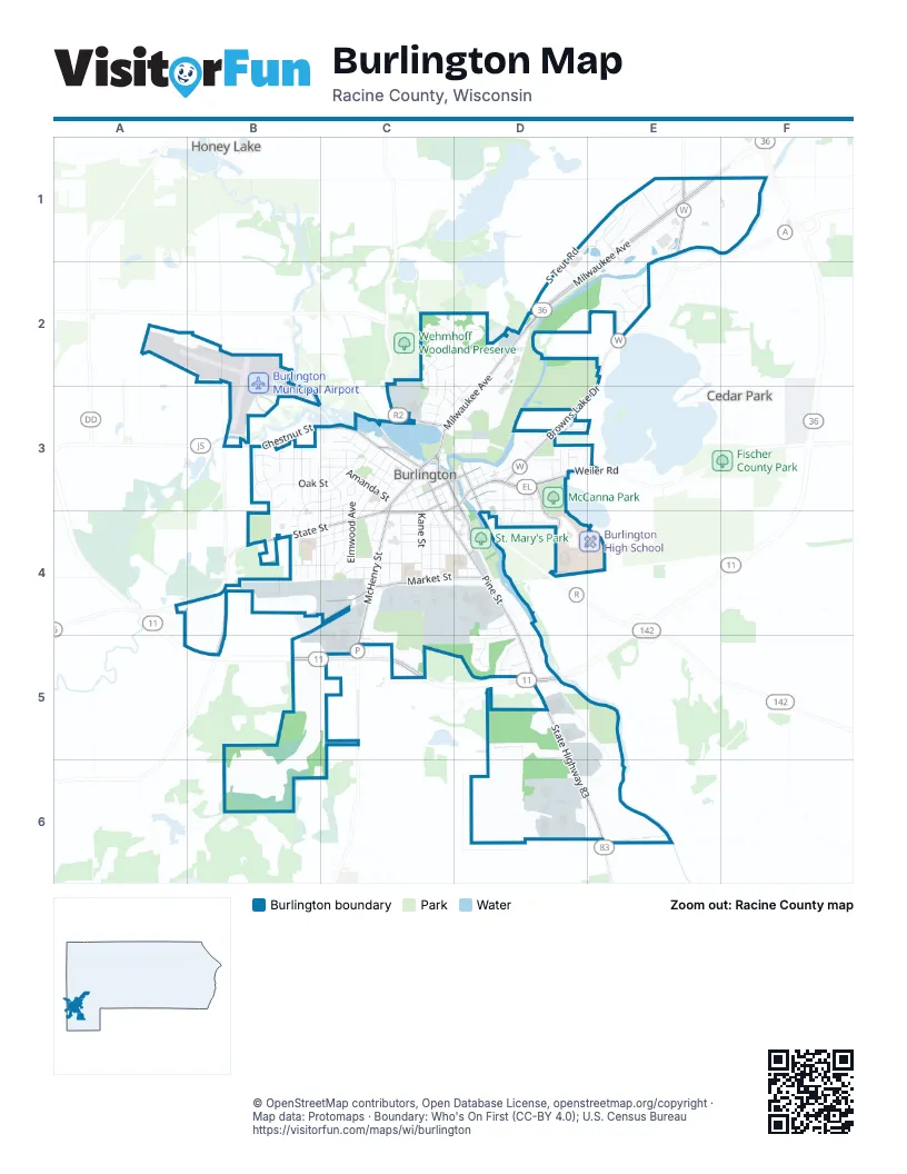
Street index of Burlington
Each street on the sheet and the grid squares it crosses.
- South Teut RoadD1, E1, D2
- Browns Lake DriveE1, E2, D3, E3
- Buckley StreetE1, E2
- Milwaukee AvenueE1, D2, E2, C3, D3, C4
- Old Spice RoadE1
- Ravenswood RoadE1
- Stonegate RoadE1
- TimberlaneE1
- Airport RoadB2
- Accipiter CourtC2
- Buteo CourtC2
- Cedar DriveC2, E2, C3
- Cooper Hawk DriveC2
- Crestwood DriveC2, C3
- Echo DriveC2, C3
- Falcon Ridge DriveC2, D2
- Joan StreetC2, D2, D3
- Joseph CourtC2
- Karyl StreetC2
- Monica AvenueC2, D2
- Peregrine CourtC2, D2
- South Honey Lake RoadC2, C3
- Droster AvenueD2
- Midwood DriveD2, C3, D3
- Walton RoadD2
- Wegge CourtD2
- Wegge RoadD2
- Barbara StreetE2
- Devon RoadE2
- Isabel LaneE2
- McWan DriveE2
- Olivia TrailE2
- Sara CourtE2
- Serena LaneE2
- Appomattax RoadB3
- Beth CourtB3, B4
- Bienemann RoadB3
- Briody StreetB3, C3
- Chantilly CourtB3
- Church StreetB3
- Gettysburgh RoadB3
- Highridge RoadB3
- Indian Bend RoadB3, B4
- Lewis StreetB3, C3
- North Kendrick AvenueB3, B4
- Oak StreetB3, C3
- Park AvenueB3, C3
- Pickett CourtB3
- Ridge RoadB3, C3
- Robins RunB3
- Shenandoah CourtB3
- Sheridan CourtB3
- Shiloh CourtB3
- Stonewall CourtB3
- Tower StreetB3, C3
- Travelers RunB3
- West AvenueB3
- West Chestnut StreetB3, C3
- West Wind RoadB3
- Westridge AvenueB3, C3, B4
- Adams StreetC3, D3, C4
- Amanda StreetC3
- Bieneman RoadC3
- Bridge StreetC3, D3, D4
- Center StreetC3
- Congress StreetC3, D3
- Conkey StreetC3, C4
- East Chestnut StreetC3
- East Jefferson StreetC3, D3
- East State StreetC3, D3, C4
- East Washington StreetC3, D3
- Entrance 1C3
- Entrance 2C3
- Entrance 3C3
- Fox StreetC3
- Grove StreetC3
- Herman StreetC3
- Hickory DriveC3
- Hillcrest DriveC3
- James StreetC3
- Johnson StreetC3, C4
- Kendall StreetC3, C4
- Madison StreetC3, D3
- McHenry StreetC3, C4, C5
- Mill StreetC3
- North Dodge StreetC3
- North Elmwood AvenueC3, C4
- North Kane StreetC3, C4
- North Maple AvenueC3, C4
- North Oakland AvenueC3, C4
- North Perkins BoulevardC3
- North Pine StreetC3
- Origen StreetC3
- Paul StreetC3, D3
- Peters ParkwayC3
- Pleasant AvenueC3
- Reynolds AvenueC3
- Ridge AvenueC3
- Smith StreetC3
- South Dodge StreetC3
- South Perkins BoulevardC3, C4
- South Pine StreetC3, C4, D4, D5
- Storle AvenueC3
- Terrace AvenueC3
- Teutonia DriveC3
- Tower Lawn DriveC3
- Tower RoadC3
- Walnut StreetC3, B4
- West Jefferson StreetC3
- West Washington StreetC3
- Bay Ridge LaneD3
- Bear Arbor DriveD3
- Bushnell RoadD3, D4
- Capital StreetD3
- Chapel TerraceD3, D4
- Chicory RoadD3
- Circle CourtD3
- Clover DriveD3
- Davidson DriveD3, E3
- Delaware AvenueD3
- Durand AvenueD3
- Edgewood DriveD3
- Evergreen CourtD3, D4
- Foxtrail CircleD3
- Foxtree CircleD3
- Larkspur CourtD3
- Larkspur LaneD3
- Maryland AvenueD3
- McCanna ParkwayD3, D4
- Michigan AvenueD3
- North Main StreetD3
- North Spring StreetD3
- North Wisconsin StreetD3
- Parkview DriveD3, D4
- Ridgemont DriveD3, E3
- Ridgeview DriveD3, D4
- South Spring StreetD3
- South Wisconsin StreetD3
- Terry LaneD3
- Uhen CourtD3
- Viewcrest TerraceD3, D4
- Weiler RoadD3, E3
- Cowdrey StreetE3
- Austin RoadB4
- Bluebird LaneB4
- Cardinal CircleB4
- Highway 36B4
- Hillside DriveB4, C4
- Jennifer AvenueB4
- Kings CourtB4
- Meadowlark DriveB4
- Orchard StreetB4, C4
- Rose Ann DriveB4, C4
- South Kendrick AvenueB4
- Spring Valley RoadB4, B5
- West State StreetB4, C4
- Beloit StreetC4
- Brookview AvenueC4, C5
- Dardis DriveC4
- Donald DriveC4
- Duane StreetC4
- Dutton StreetC4
- East Chandler BoulevardC4
- East Highland AvenueC4, D4
- East Market StreetC4, D4
- Edward StreetC4
- Emerson StreetC4
- Front StreetC4
- Gardner AvenueC4
- Garfield AvenueC4
- Hawthorn StreetC4
- Henry StreetC4
- Industrial DriveC4, D4
- Lincoln StreetC4
- Long Meadow DriveC4, D4
- McKinley StreetC4
- Northrop StreetC4
- Randolph StreetC4
- Robert StreetC4, D4
- Saint Marys StreetC4
- Schemmer StreetC4
- Sheldon StreetC4
- South Elmwood AvenueC4
- South Kane StreetC4
- South Maple AvenueC4
- South Oakland AvenueC4
- Summit AvenueC4
- Sunset DriveC4
- Wainwright AvenueC4, D4
- West Chandler BoulevardC4
- West Highland AvenueC4
- West Market StreetC4
- Alice StreetD4
- Calumet StreetD4
- Crest StreetD4
- Dale DriveD4, D5
- Dunford DriveD4
- Krift AvenueD4, D5
- Mary StreetD4
- Meadow LaneD4
- Burlington BypassB5, C5, D5
- Eastbrook DriveD5
- Haynes CourtD5
- Hidden Creek LaneD5
- Margaret CourtD5
- Springbrook DriveD5
- State Highway 83D5, D6, E6
- Tributary LaneD5
- Yahnke RoadD5
- Black Hawk DriveD6
- Liberty DriveD6, E6
- Whiting RoadD6
Places on the map
- Advance Auto Parts
- ALDI
- America’s Gunsmith Shop
- AmericInn by Wyndham Burlington
- Associated Bank
- Aurora Memorial Hospital of Burlington
- Aurora Wellness Center
- Auto Gallery LLC
- Ayra's
- B Towne Auto Service
- B.J. Wentker's Historic Fine Dining
- Beaumont & Congress Fields
- Beaumont Field
- Beijing Garden Chinese Food
- Berkot's Super Foods
- BMO
- Brannen Field
- Browns Lake Golf Course
- Bubba's Brickyard
- Burlington Baseball Diamond
- Burlington City Hall
- Burlington Fire Department
- Burlington High School
- Burlington Historical Society
- Burlington Municipal Airport
- Burlington State Habitat Area
- Devor Park
- Echo Veterans Memorial Park
- Hintz Complex
- Historic Downtown Burlington
- Lynch Chevrolet
- McCanna Park
- Menards
- Pinecrest
- Riverside Park
- Saint Charles Cemetery
- Saint Mary Cemetery
- St. Mary's Park
- Wagner Park
- Walmart Supercenter
Next to Burlington
- Browns Lake
- Cedar Park
- Honey Lake
© OpenStreetMap contributors, Open Database License, openstreetmap.org/copyright · Map data: Protomaps · Boundary: Who's On First (CC-BY 4.0); U.S. Census Bureau















