

Wisconsin map
Southeast Wisconsin map
The sheet's index lists 27 highways; I-43, I-41 and US 41 cross the most grid squares. Things to do inside the boundary: American Family Field, Bender Beach and Best Place at the Historic Pabst Brewery. Also on it: Brookfield, Burlington and Caledonia.
Open the map (PDF, US Letter)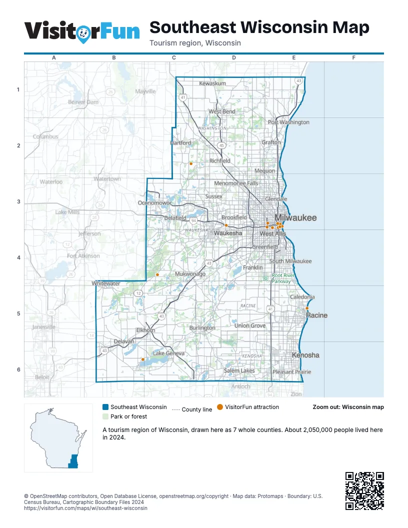
Highway index of Southeast Wisconsin
Each highway on the sheet and the grid squares it crosses.
- I-41C1, C2, D2, D3, D4, E4, E5, E6
- I-43B5, B6, C4, C5, D4, E1, E2, E3, E4
- I-94C3, D3, E3, E4, E5, E6
- I-794E3, E4
- I-894D3, D4, E4
- US 12B4, B5, C5, C6
- US 14B5, B6
- US 41C1, C2, D2, D3, D4, E4, E5, E6
- US 45D1, D2, D3, D4
- WI 11B5, C5, D5, E5
- WI 16C3, D3
- WI 32E1, E2, E3
- WI 36C5, D5
- WI 50C6, D6, E6
- WI 57E2
- WI 59B5
- WI 67B5, C3, C5
- WI 83D5, D6
- WI 89B4, B5
- WI 100D3
- WI 119E4
- WI 120C6
- WI 145D3
- WI 164D3
- WI 167D2
- WI 175E3
- WI 794E4
Things to do on the Southeast Wisconsin map
- American Family Field
- Best Place at the Historic Pabst Brewery
- Big Foot Beach State Park
- Boerner Botanical Gardens
- Clark House Museum
- Dousman Stagecoach Inn Museum
- Edelweiss Cruise Lines
- Forest Exploration Center
- Fox River Sanctuary
- Great Lakes Distillery
- Grohmann Museum
- Harley-Davidson Museum
- Hawks Inn & Delafield History Center
- Henry Maier Festival Park (Summerfest Grounds)
- Heritage Trails County Park
- Historical Park
- Holy Hill
- Kettle Moraine Low Prairie State Natural Area
- Lake Park
- Mayfair Mall
- Miller Brewery Tour
- Milwaukee Art Museum
- Milwaukee County Zoo
- Milwaukee Public Museum
- Mitchell Park Domes
- Mukwonago Historical Society - Red Brick Museum
- Museum of Wisconsin Art
- National Bobblehead Hall of Fame and Museum
- New Berlin History Museum
- North Point Water Tower
- Oconomowoc Area Historical Society and Museum
- Old World Wisconsin
- Patrick and Beatrice Haggerty Museum of Art
- Potawatomi Casino Hotel
- Pritchard Park Mall
- Racine Art Museum
- Racine Zoo
- Retzer Nature Center
- Richfield Historical Park
- Schleisingerville to Slinger Historical Museum
- The Avenue (Milwaukee)
- The Civil War Museum of Delafield
- The Corners of Brookfield
- Thomas A. Greene Memorial Museum
- Virmond Park
- West Allis Historical Society
- Wisconsin Automotive Museum
- Wisconsin Museum of Quilts & Fiber Arts
- Yerkes Observatory
Places on the map
- Brookfield
- Burlington
- Caledonia
- Delafield
- Delavan
- Elkhorn
- Franklin
- Glendale
- Grafton
- Greenfield
- Hartford
- Kenosha
- Kewaskum
- Lake Geneva
- Menomonee Falls
- Mequon
- Milwaukee
- Mukwonago
- Oconomowoc
- Pleasant Prairie
- Port Washington
- Racine
- Richfield
- Salem Lakes
- South Milwaukee
- Sussex
- Union Grove
- Waukesha
- West Allis
- West Bend
- Whitewater
Next to Southeast Wisconsin
- Chicago & Beyond
- Northeast Wisconsin map
- South Central Wisconsin map
© OpenStreetMap contributors, Open Database License, openstreetmap.org/copyright · Map data: Protomaps · Boundary: U.S. Census Bureau, Cartographic Boundary Files 2024