

Wisconsin map
Marshfield map
About 17,907 people live here (Census Bureau, 2024 estimate). The sheet's index lists 300 streets; Veterans Parkway, South Central Avenue and North Lincoln Avenue cross the most grid squares. Also on it: Marshfield Municipal Airport, Marshfield Air Park and Mill Creek Business Park.
Open the map (PDF, US Letter)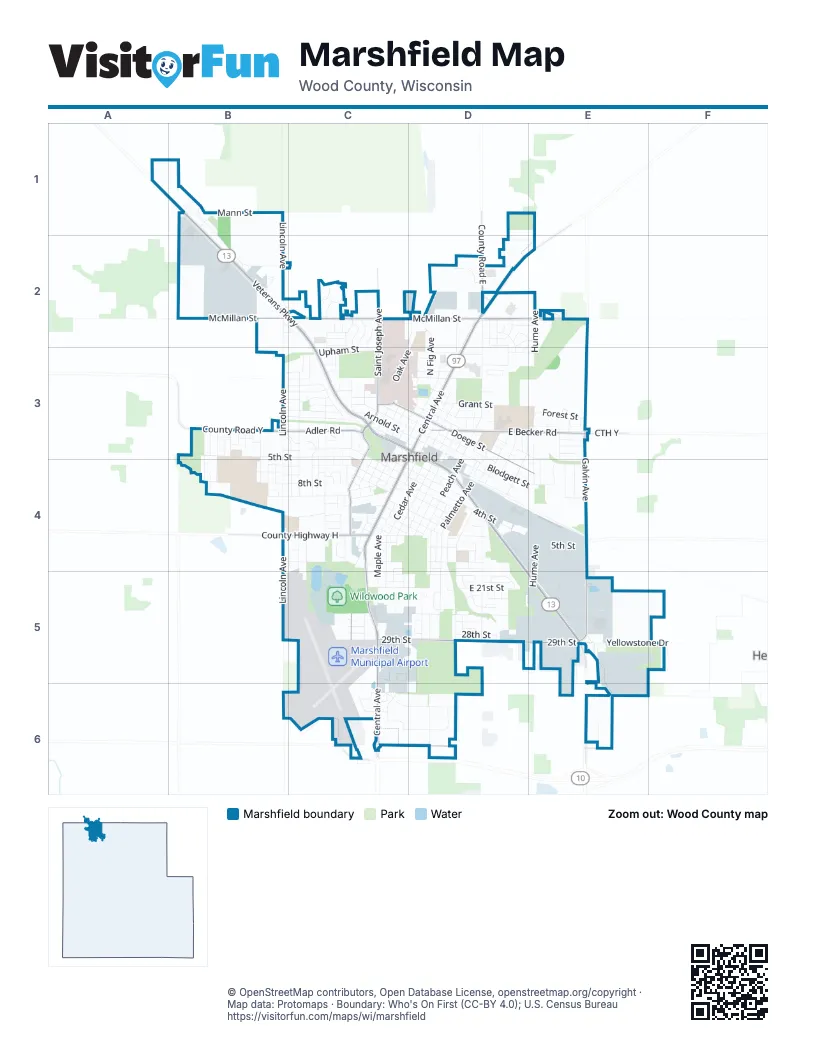
Street index of Marshfield
Each street on the sheet and the grid squares it crosses.
- Veterans ParkwayB1, B2, C2, C3, D3, D4, E5, E6
- South Central AvenueD3, C4, C5, C6
- North Central AvenueD2, E2, D3
- State Highway 97E2
- West McMillan StreetB2, C2, D2
- South Oak AvenueC3, C4, C5
- North Galvin AvenueE2, E3, E4
- East Becker RoadD3, E3
- County Highway HB4, C4
- East 29th StreetC5, D5, E5
- Saint Joseph AvenueC2, C3
- East McMillan StreetD2, E2
- East Doege StreetD3, D4, E4
- South Galvin AvenueE4, E5
- Heritage DriveC6, D6, E6
- County Road YB3
- Adler RoadB3, C3
- County Road ED2
- West Doege StreetC3, D3
- McMillan StreetB2, C2
- CTH YE3
- North Lincoln AvenueB1, B2, C2, B3
- East 4th StreetC4, D4, E4
- West 5th StreetB3, C3, C4
- South Maple AvenueD3, C4, D4, C5
- South Peach AvenueD4, D5
- North Peach AvenueD2, D3, D4
- East 8th StreetC4, D4
- South Lincoln AvenueB3, B4, B5
- West Upham StreetC2, C3, D3
- East Blodgett StreetD3, D4, E4
- Large Animal DriveC4, C5
- South Palmetto AvenueD4, D5
- South Adams AvenueC3, C4
- South Vine AvenueC4, D4, C5
- North Hume AvenueE2, E3, E4
- East 21st StreetC5, D5, E5
- South Cherry AvenueC4, D4, C5, C6
- South Cedar AvenueC4, D4, C5
- South Schmidt AvenueC3, C4, C5
- West Blodgett StreetB3, C3, D3
- North Chestnut AvenueD2, C3, D3
- South Washington AvenueD4, D5
- West 4th StreetB3, C3, C4
- North Oak AvenueC2, D2, C3
- West 6th StreetB4, C4
- East 17th StreetC4, D4
- East Arnold StreetD3, D4, E4
- Mann StreetB1
- West 8th StreetB4, C4
- South Hume AvenueE4, E5
- East 5th StreetC4, D4, E4
- East 25th StreetC5, D5
- South Apple AvenueD4, D5
- South Felker AvenueD4, D5
- West 7th StreetB4, C4
- East Depot StreetD3, D4
- North Walnut AvenueC3, D3
- East Fillmore StreetD3, E3, E4
- East Commerce DriveC6, D6
- West 11th StreetB4, C4
- South Chestnut AvenueC3, C4
- Madison AvenueD4, D5
- North Cedar AvenueD3
- Arlington StreetB4, C4
- North Palmetto AvenueD2, D3, D4
- West Ives StreetB3, C3, D3
- North Hinman AvenueD2, D3, D4
- East Cleveland StreetD3, D4
- West Kalsched StreetC3, D3
- West 17th StreetB4, C4
- East 15th StreetC4, D4
- Forest StreetE3
- East 6th StreetC4, D4
- East 14th StreetC4, D4
- North Wood AvenueC2, C3
- Yellowstone DriveE5
- West Arnold StreetC3, D3
- North Maple AvenueD3
- Frontage RoadC2, C3
- North Willow AvenueD3, D4
- East 3rd StreetC4, D4
- Corporate AvenueC6, D6
- West Veterans ParkwayB2
- Maryknoll AvenueB3, C3, C4
- North Schmidt AvenueC3
- Popp AvenueB1, B2
- East 9th StreetC4, D4
- West State StreetB3, C3
- North Pine AvenueC3
- North Fig AvenueD2, D3
- North Anton AvenueE3, E4
- East 20th StreetC5, D5
- North Adams AvenueC2, C3
- North Apple AvenueD2, D3, D4
- East 2nd StreetC4, D4
- East 26th StreetD5, E5
- East 19th StreetC5, D5
- East 18th StreetC4, D4, E4
- North Cherry AvenueD3
- Cherry StreetC5, C6
- West 3rd StreetB3, C3, C4
- South Linden AvenueB3, B4
- Sycamore AvenueB3, B4
- North Broadway AvenueC2, C3
- West Park StreetC4
- West Spencer StreetB2
- South Spruce AvenueC3, C4
- Pecan ParkwayD5
- South Ash AvenueD4
- East Franklin StreetD3
- South Anton AvenueE4, E5
- East Edison StreetD3
- East Upham StreetD3, E3
- South Locust AvenueC4
- West Cleveland StreetC3, D3
- West Jefferson StreetB3, C3, D3
- West Depot StreetC3, D3
- Business Park DriveD6
- East Grant StreetD3
- Jefferson StreetD3
- Western StreetC3
- Butternut ParkwayD4, D5
- North Juno AvenueD3, D4
- South Balboa AvenueC4, C5
- South Cypress AvenueB3, B4
- North Ash AvenueD3
- Hawthorn AvenueB3, B4
- Laemle AvenueE4, E5
- South Tamarack AvenueD4, D5
- Briarwood StreetB3, C3
- West 29th StreetC5
- Marathon StreetB2, C2, C3
- South Pine AvenueC4
- East 28th StreetD5
- North Vine AvenueD3, D4
- South Mallard AvenueE5, E6
- Fairview DriveB3, C3
- South Drake AvenueC3, C4
- Downwind DriveC6
- South Columbus AvenueC3, C4
- East 10th StreetC4, D4
- Renee LaneD2, E2, D3
- Wilderness View DriveD2, E2
- Waushara DriveD2
- South Walnut AvenueC3, C4
- Ridge RoadB3, C3
- Wisconsin AvenueC3, C4
- East Ives StreetD3
- Meadow LaneE4
- East 22nd StreetD5, E5
- Columbus DriveC3
- Green Acres DriveD5
- North Frey AvenueB1
- Pheasant Run DriveC2
- East 11th StreetC4
- South Hemlock AvenueD4
- South Popple AvenueD4, E4
- North Spruce AvenueC3
- South Birch AvenueB3, B4
- Highview DriveD2
- Erickson AvenueD4
- West 2nd StreetC3, C4
- Laird StreetC2
- Onstad DriveC3
- North Shawano DriveC2, C3
- Wildwood CourtC4
- South Wallonnie DriveD5
- Magee StreetC4
- South State AvenueC3
- 34th StreetE6
- Devine DriveC4
- North Plum AvenueD3
- Sawyer DriveC3
- West North StreetC3
- East Kalsched StreetD3
- Holly AvenueB3, B4
- Larch AvenueB3
- South Cedar StreetC5
- East Hintz StreetE3
- Lawraine StreetE3
- South Wittman AvenueC5
- Palmetto AvenueD3
- Meadowbrook DriveE4
- North Auburn AvenueE3, E4
- Emerald StreetE3
- Meadow AvenueC2
- South Draxler DriveE6
- Wallonie DriveD5
- West 12th StreetC4
- West 26th StreetC5
- Carmen DriveD2
- North Irene AvenueE3
- South Roddis AvenueC4
- West 13th StreetC4
- Prairie DriveC2
- North Columbus AvenueC3
- U W DriveB3, B4
- East Enterprise DriveC6
- Heide LaneD2, E2
- Westview DriveC3
- Willow AvenueD4
- Martin DriveC4
- South Auburn AvenueE4, E5
- Ash StreetD2
- Chapel StreetC2
- Debra LaneD2, E2
- Cherry AvenueC5
- East 23rd StreetD5
- East Harrison StreetD3
- South Maywood AvenueD5
- Mannville LaneB1
- North Weber AvenueD3
- Vine AvenueC4, C5
- South Karau DriveD4
- Hickory LaneB3, C3
- West Huetter StreetB1
- Colonial StreetC2
- North Hills AvenueC2, C3
- Monique LaneE3
- East Vilas StreetD2
- North Bluebird AvenueE4
- Wildflower DriveC2
- Evergreen AvenueB3
- Praschak StreetC5
- Laurel StreetC3
- South Concord AvenueC3
- Highland AvenueC4
- Air Park RoadC6
- West Marathon StreetC3
- North Hamus DriveD2
- West 9th StreetC4
- Anton CourtE3
- West Edison StreetD3
- Magnolia DriveB3
- North Elm AvenueD4
- North Purdy AvenueD4
- West 27th StreetC5
- West 28th StreetC5
- East Forest StreetD3
- Woodsview DriveB4
- East 12th StreetC4
- Shortess DriveB2
- East 7th StreetD4
- Bluebird LaneE4
- Praschek ParkC5
- East 24th StreetE5
- George DriveC4
- Frey CourtB1
- Grant StreetD3
- West Leonhard StreetD3
- West 25th StreetC5
- North Balsam AvenueC3
- East 27th StreetD5
- South Clark AvenueC4
- Ley AvenueB3
- Northridge StreetD2
- West 1st StreetC3, D3
- Mulberry AvenueB3
- East 1st StreetD4
- Circle DriveD3
- South Basswood AvenueD5
- South Aspen AvenueD5
- South Cottonwood AvenueD5
- Drake CourtC3
- South Severns AvenueC4
- Nelson StreetB2, C2
- North Hills DriveC2
- South Ironwood AvenueD5
- North Juniper AvenueE3
- Luther CourtC2
- Immanuel CourtC2
- West Franklin StreetD3
- West Grant StreetD3
- Tremmel CourtD5
- West Harrison StreetD3
- Quentin AvenueC3, C4
- East 16th StreetC4
- Old County Road ED2
- Red Hawk LaneD2
- Short LaneE4
- West 16th StreetC4
- East Waushara DriveD2
- Laurel CourtC3
- Katherine CourtD2
- Tiny Tigers CourtD3
- 4th StreetB3
- South Prospect AvenueC4
- Weister CourtD4
- North Carmen DriveD2, D3
- Omaha StreetC4
- South Butternut ParkwayD5
- South Madison AvenueD5
- Washington CourtD4
- Eastside CircleD5
- Upham StreetC3
- Juno CourtD3
- Holly CourtB4
- Bluebird CourtE4
- 16th StreetC4
Places on the map
- Advance Auto Parts
- Aldi
- AmericInn by Wyndham
- Applebee's
- Arby's
- Baltus Car Wash
- Baltus Full-Service Car Wash
- Baymont
- Beell Stadium
- Benedict Park
- Bison
- Braem Park
- Burger King
- Central Wisconsin Fairgrounds
- Grant Elementary School
- Griese Park
- Hillside Cemetery
- Lower Pond
- Madison Elementary School
- Marshfield Agricultural Research Station South Campus
- Marshfield Air Park
- Marshfield Children's Hospital
- Marshfield High School
- Marshfield Junior High School
- Marshfield Medical Center - Marshfield
- Marshfield Municipal Airport
- Marshfield Post Office
- Menards
- Mill Creek Business Park
- Miller Recreation Area
- Norwood Health Center
- Praschak Park
- Upper Pond
- Walmart Supercenter
- Washington Elementary School
- White-tailed Deer
- Wildwood Park
- Wildwood Zoo
- Zoo Drive
© OpenStreetMap contributors, Open Database License, openstreetmap.org/copyright · Map data: Protomaps · Boundary: Who's On First (CC-BY 4.0); U.S. Census Bureau















