

Wisconsin map
Wood County map
About 73,943 people live here (Census Bureau, 2024 estimate). The sheet's index lists 300 streets; State Highway 73, County Line Road and County Highway N cross the most grid squares. Also on it: Wood County Forest, Wood County Wildlife Area and Sandhill Wildlife Area.
Open the map (PDF, US Letter)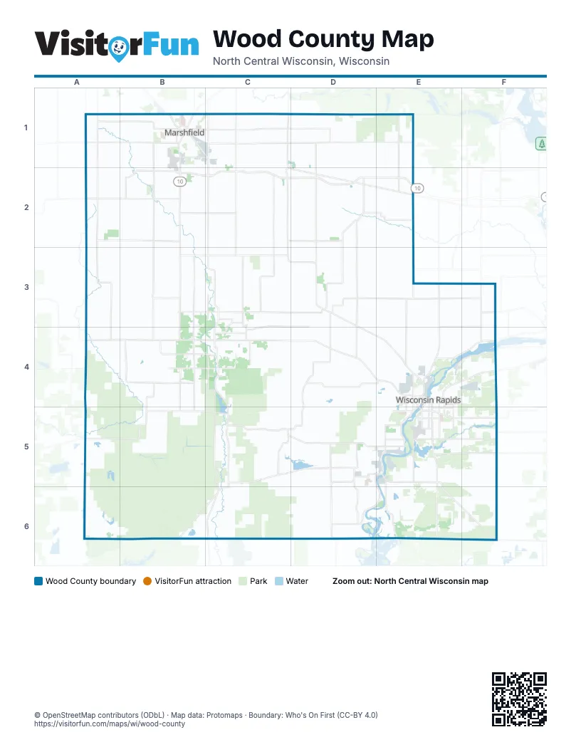
Maps inside Wood County
3 maps inside, from the street map of Wood County down.
Street index of Wood County
Each street on the sheet and the grid squares it crosses.
- US Highway 10A2, B2, C2, D2, E2
- State Highway 73A4, B4, C4, D4, E4, E5, E6, F6
- State Highway 80B2, B3, B4, C4, C5, C6
- State Highway 54A5, B5, C5, D5, E5
- State Highway 173C5, D5, B6, C6
- Plover RoadE4, F4, E5
- Veterans ParkwayB1, C1, C2
- 8th Street SouthE4, E5
- State Highway 66E4, F4
- State Highway 13E5, E6
- Mill AvenueE5, F5
- East Riverview ExpresswayE4, E5
- West Grand AvenueE4
- Wood AvenueD5, E5, F5
- 2nd Avenue SouthE4, E5
- Wisconsin River DriveE5
- West Riverview ExpresswayE4
- Letendre AvenueE5
- Prospect AvenueE5
- Market StreetE4, D5, E5
- 1st AvenueC4
- Cedar StreetC1, C5, D5
- Adams AvenueE5, F6
- Vietnam War Veterans Memorial HighwayB2
- State Highway 186C2, C3, D3, D4
- 80th Street SouthF4, F5, F6
- Rangeline RoadD1, D2, E5, E6
- County Highway GD5, D6
- Griffith AvenueE5, F5
- South Central AvenueB1, B2
- County Highway ZE5
- Kellner RoadE5, F5
- County Highway WE5
- North Central AvenueB1
- Wisconsin StreetC3, D3, E4
- Baker StreetE4
- East Cameron AvenueD3
- Baker DriveE4
- West Cameron AvenueD3
- 8th Street NorthE4
- County Road GD6
- County Highway VA1, A2, A3, A4, B4
- County Highway NE1, A2, B2, D2, E2, B3, C3
- County Highway BB1, B2, B3, B4
- County Highway EastC2, C3, B4, C4, B5
- County Highway SE1, E2, E3, E4
- County Highway AC2, C3, C4
- Main StreetC2, D2, E2, E3, C4, F5
- County Highway DD4, C5, D5
- County Highway CB3, C3, D3
- Elm RoadC2, D2, F3, C4, D4
- County Highway FD3, D4, E4
- CTH YC1, D1
- Seneca RoadD5, E5
- Heritage DriveB2, C2
- Park RoadA2, B2, E3, C4, C5, E5
- County Highway HA1, B1
- County Road CD3, E3
- Polish RoadB3, B4
- County Road XC5, C6
- County Highway QD4, E4
- Dairy RoadD2, B4, B5
- County Road YA1, B1
- County Highway XB4, B5
- County Road AAD6, E6
- Townline RoadE5, F5
- Apple RoadC3, C4, D4
- Jackson RoadC3, D3, C4
- Bethel RoadC3
- County Road EEB2, C2
- County Highway HHD3, D4
- Oak StreetD3, C4, E4, C5, C6, F6
- East McMillan StreetB1, C1
- Dexter-Wood RoadB4, C4
- County Road JJD5, D6
- North Biron DriveE4, F4
- County Highway OF3, F4
- 32nd Street SouthE4, E5
- County Road DDE3, F3
- County Road GGD5
- Lincoln StreetE4, E5
- 16th Street SouthE4, E5
- Chestnut StreetE5
- Two Mile AvenueE5
- Peach StreetE4
- Hilltop RoadC4
- North Galvin AvenueC1
- County Road EC3, C4
- Ver Bunker AvenueE5
- West McMillan StreetB1
- County Highway CCB3
- East 29th StreetB1, C1
- 3rd Street SouthE4, E5
- Copper LaneC3
- County Highway N/SE2
- South Biron DriveE4
- Port RoadE5
- Pepper AvenueE5
- South Oak AvenueB1
- Deer LaneC4, E5, D6
- 1st Street SouthE3, E5
- Point Basse AvenueD5, E5, E6
- Gaynor AvenueE5
- Pine StreetD3, C4, E4, C5, E5, C6, F6
- South County Highway BBB2
- County Road HHD3
- Shady LaneA1, B4, E5
- East Becker RoadB1, C1
- Birch StreetD3, E4, C5, D5, C6
- 80th Street NorthF4
- 25th Avenue SouthE4, E5
- Chase StreetE4
- Sunset RoadC3, C5
- Bonow AvenueE4
- Ubinger RoadC4
- 3rd Street NorthE3, E4
- East Doege StreetB1
- 17th Avenue SouthE4, E5
- East Grand AvenueE4
- County Highway PPF3
- Range Line RoadD1
- South Galvin AvenueC1
- Blenker RoadD2
- County Highway UE4, F4
- Saint Joseph AvenueB1
- County Highway PC2, E2
- County Highway MC1, C2
- Adler RoadB1
- Sunrise LaneB3
- 16th Street NorthE4
- East Jackson StreetE4
- Veedum StreetC4
- Jackson StreetC4, E4
- West Jackson StreetE4
- White StreetD3
- West Doege StreetB1
- County Road WF5
- County Road VA1
- Swallow LaneC4
- County Road ZA5
- Rabbit LaneC4
- Homestead LaneC3
- Wilderness RoadB4
- County Road MC1, E3
- Wilson StreetE4
- County Road WWF5
- County Road HA1
- Cedar LaneB4
- Biron Drive EastF4
- County Road FFF5
- North RoadD1, D2, D3, D4
- Mill Creek DriveA2, B2, C2
- County Line RoadC1, D1, E3, F3, B6, C6, E6, F6
- Robin RoadB1, B2, B3
- Bluff DriveA3, B3, C3
- South Lincoln AvenueB1, B2, B3
- Ball RoadA5, B5, C5
- Falcon RoadB1, B2, B3
- Eagle RoadA1, A2, A3
- Yellowstone RoadC1, D1, E1
- Oak RoadC3, C4, E4, F4
- Swedish RoadE2, E3, E4
- 64th Street SouthF4, F5, F6
- 1st Street EastC6, D6
- Richfield DriveB2, C2, D2
- Rock Inn RoadC1, C2
- Batterman RoadC6, D6
- Lincoln RoadC4, D4
- Stadt RoadC1, C2
- 5th Avenue NorthE3, E4
- Grant RoadC3, D3
- Klondike DriveB2, C2
- Church AvenueE5, F5
- Brookside RoadD1, D2
- Maple RoadC2, D2, E3
- South Washington AvenueB1, B2
- Day RoadC1, C2
- Kimball AvenueD5, D6
- Lynn Hill RoadD6, E6
- Spruce RoadC2, D3, D4
- Maplewood RoadC3, C4
- Tower RoadE3, F3, E6, F6
- Fair Haven AvenueA1, A2, A3
- Yellowstone DriveC1
- Ranger RoadE5, F5
- Town Hall RoadD3, E3, C5
- Hetze RoadE2, E3
- Arpin-Richfield RoadC2, C3
- 3rd Avenue NorthE3, E4
- Hemlock RoadC4, D4
- Ten Mile AvenueE6
- West Fence LaneB5, B6
- Arpin-Sherry RoadD2, D3
- Creamery RoadC6, D6
- Washington StreetC4, E4, F4
- Steffek RoadA3, B3
- Eisenhower DriveA2, B2
- 2nd Avenue NorthF3, E4, F4
- Reddin RoadE4
- Patton DriveA3, B3
- Smokey Hill RoadD1, D2
- Lumberg RoadD3, D4
- Evergreen AvenueB1, E6, F6
- 52nd Street SouthF5, F6
- 48th Street SouthF4, F5
- Shady RoadC1, C2
- Blueberry RoadE1, E2
- Plum RoadE3, F3
- Tower DriveD2
- Amundson RoadB6
- Cary-Rock DriveA3, B3
- Lindsey RoadA3, A4
- Pine RoadC3, E4
- Macarthur DriveA2, B2
- Trestik DriveD2, E2
- Necedah RoadC6
- Pleasant Hill RoadC1, D1
- Yellow River RoadA1, B1
- Rocky Run RoadE2, B3, C3
- Johnson RoadB3, B4
- Church RoadC2, C3
- Airport AvenueE5, F5
- George RoadE4, E5
- Hoffman RoadB4, D6
- Whitrock AvenueE5, F5
- Cranberry RoadE4, A5, A6
- West StreetE2
- Vruwink RoadD2, D3
- Mayflower RoadD1, D2
- Hay Creek RoadA4, B4
- Marsh RoadF3, D4, E4, F4
- Grove AvenueE5, F5
- Rose RoadD3, E3
- Cary Hiles RoadB4
- South Hollywood RoadE5, E6
- Wilhorn RoadD5, E5
- Tresik DriveD2
- Richfield Wood RoadC3
- West 5th StreetB1, C1, D5, E5
- Deer RoadE5, F5
- Stout Marsh RoadA6, B6
- Old 10C2
- Lincoln Spencer RoadA1, B1
- Yetter RoadB4
- Ruess RoadD3, D4
- Bell RoadE6
- Deer Ridge RoadE6, F6
- Puff Creek BoulevardC3
- Partner RoadE2
- 64th Street NorthF4
- Lonesome RoadC5
- 48th Street NorthF4
- Weisner RoadB5
- Range RoadD4, D5
- Blue Ridge LaneE6
- Park RoadsC3
- Hemlock TrailC4, C5
- 1st StreetC1, D1, D3, C4, D5, E5
- McKeel RoadC6
- Richfield RoadB3, C3
- Butternut RoadC3, D3, E3
- 3rd StreetD1, D2, E2, D3, C4, E5
- Deer Run DriveE1
- Fisher RoadE4
- 6th AvenueE3, C4, E4
- Tenpas RoadD3
- Poplar DriveD1
- Lonely RoadD3, E3
- Sampson StreetE5
- Accola RoadA4
- Progress RoadA3, B3, B4
- Chapel RoadE3
- Lone Pine RoadE4
- Knuth RoadD4
- Ward BoulevardC3
- Meunier RoadD4
- Hickory RoadC3, C4
- 1st Street NorthE3, E4
- Saint Johns RoadD4, E4
- Green Elm RoadD3
- Wazeecha AvenueF5
- East 4th StreetB1, C1
- Young RoadD4
- Nepco Lake RoadE5
- Becker RoadD1
- Ridge RoadB1, D4
- 2nd StreetD1, D2, E2, D3, C4, E5
- Ingram RoadB6
- 12th Street SouthE4, E5
- Hillcrest AvenueE3, E6
- Zimmerman RoadB6, C6
- Arpin Hansen RoadD3
- Searles RoadD4
- West Ives StreetB1
- 4th StreetB1, C4, E5
- 10th Street SouthE4, E5
- Daly AvenueE5, F5
- Saratoga StreetE4
- Sparks RoadA3
- Swanson RoadD5
Places on the map
- 44 Reservoir
- Arpin
- Auburndale
- Big Island
- Biron
- Biron Business Park
- Bull's Eye Country Club
- Cranberry Creek Landfill
- Domtar
- Hewitt
- Lake 28-11 8
- Lake Dexter
- Lake Wazeecha
- Marshfield
- Marshfield Air Park
- Marshfield Country Club
- Marshfield Municipal Airport
- Marshfield School Forest
- Mill Creek Business Park
- Milladore
- Nekoosa
- Nepco Lake
- Nepco Lake County Park
- North Wood County Park
- Pittsville
- Pittsville School Forest
- Port Edwards
- Powers Bluff County Park
- River Edge Golf Course
- Riverside Park
- Ross Lake
- Rudolph
- Sandhill Wildlife Area
- Saratoga Cranberry Co.
- South Wood County Airport
- South Wood County Park
- The Ridges Golf Course
- Town of Arpin
- Wood County Forest
- Wood County Wildlife Area
© OpenStreetMap contributors, Open Database License, openstreetmap.org/copyright · Map data: Protomaps · Boundary: Who's On First (CC-BY 4.0); Quattroshapes (CC BY 2.0)















