

Wisconsin map
Plover map
About 14,208 people live here (Census Bureau, 2024 estimate). The sheet's index lists 300 streets; Plover Road, Hoover Avenue and Post Road cross the most grid squares. Things to do inside the boundary: Food + Farm Exploration Center.
Open the map (PDF, US Letter)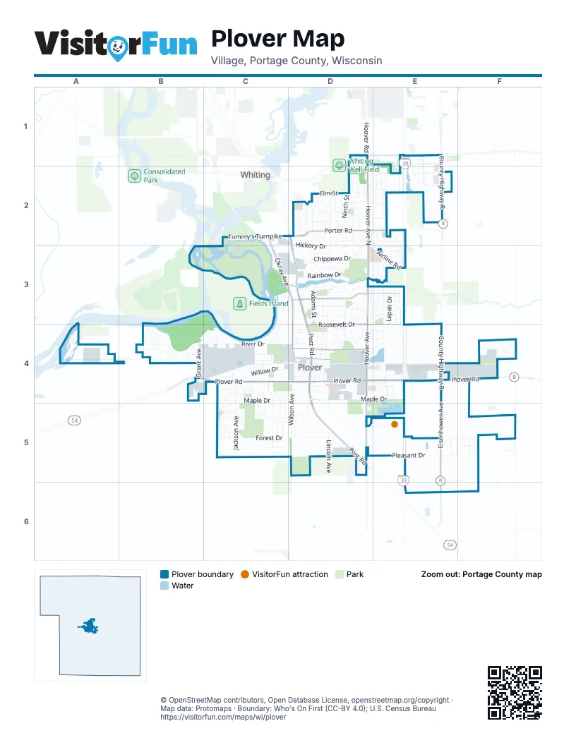
Street index of Plover
Each street on the sheet and the grid squares it crosses.
- Plover RoadB4, C4, D4, E4, F4
- Post RoadD2, D3, D4, D5
- State Highway 54D5
- County Highway RE1, E2, E4
- Eisenhower AvenueE4, E5, E6
- McDill AvenueD1, E1
- Brilowski RoadE1
- Hoover AvenueD1, D2, D3, D4, D5
- Hoover Avenue NorthD2, D3
- Porter RoadD2, E2
- Okray AvenueC2, C3, D3, D4
- Roosevelt DriveE3, D4, E4
- Plover Springs DriveD3, E3
- Cedar DriveD4
- Tommy's TurnpikeC2, D2
- Chestnut DriveD4
- Porter DriveE2
- Hoover RoadD1
- River DriveB4, C4, D4
- Maple DriveC4, D4, E4
- Pleasant DriveD5, E5, F5
- Forest DriveC5, D5
- Airline RoadD2, D3, E3
- Willow DriveC4, D4
- Wisconsin AvenueD3, D4
- Washington AvenueD3, D4
- Madison AvenueD3, D4
- Chippewa DriveD3
- Seventh StreetD2, D3
- Commons CircleE1, E2
- Jackson AvenueC4, C5
- Hickory DriveD2, D3
- Cleveland AvenueC4, C5
- Springvile DriveD3
- Crossroads DriveE1, E2
- Village Park DriveE4
- Easlan DriveD3, D4
- Wilson AvenueD4, D5
- Rainbow DriveD3
- Shadow View CircleD3, D4
- Evergreen DriveC4, C5
- Magnolia DriveD3
- Corporate AvenueC4
- Juniper LaneD2
- River Bend RoadC3, C4
- Ashwood DriveD2, D3
- Mecca DriveD4
- Green Tree DriveD2, E2, E3
- Conventry DriveD2
- Golden DriveD3
- Jelinski CircleD3
- Park RoadE4
- Eighth StreetD2, D3
- Patti DriveC5
- South DriveD4
- Canterbury DriveD2
- Tall Pine DriveC4
- Adams StreetD3
- Mirage CircleC4
- Oakwood AvenueE2
- Grant AvenueB4
- Maplewood DriveD4, E4
- Foremost RoadC4
- True North TrailC3, D3
- Meridian DriveE2
- Red Oak DriveD3, D4
- Norway Pine DriveE3, E4
- OK Bluff CircleB4
- Fourth StreetD2
- Elm StreetD2
- Ninth StreetD2
- Lombard DriveD2, E2
- Lepak DriveE3, E4
- Twin Towers DriveF4
- Weslan DriveD4
- Fifth StreetD2
- Aspen LaneC3, D3, C4
- Zblewski DriveE2, E3
- Arbor Haven WayF5
- Third StreetD2
- Green DriveD4
- Mission LaneC4
- Pine Tree AvenueD5
- Lincoln AvenueD5
- Gilman DriveC4, D4
- Highland DriveD2, E2
- Ponderosa StreetD2, E2
- Roger's DriveE2, E3
- Still Meadow LaneB4
- Pineries RoadD3
- Exploration WayD5, E5
- Fawn LaneD2
- Butternut StreetD2
- Sandy Acres DriveC4, C5
- Black Forest DriveF4
- Revere RoadC4
- Nassau BoulevardC4
- Ridgewood CircleD3
- Meadow LaneD4
- Moore RoadF4
- Ramble LaneD2
- Haga DriveD5
- Earhart AvenueD4
- Clar-Re DriveD4, E4
- Tamarack StreetD2, E2
- Green Pastures TrailE5, F5
- Fieldstone DriveB4
- Truman AvenueB4
- Torrey Pines WayE5, F5
- Anne Marie DriveC5
- Rosewood DriveC4, C5
- Hoffman DriveC4, C5
- Kerrington PlaceC5
- Katherine CircleC4
- Johnson AvenueD4, D5
- Heatherton LaneD3
- Page DriveC5
- Royal Oak DriveC5
- River Edge CourtC4
- Oneida DriveD3
- Locust DriveD4
- Opportunity LaneD4
- Menards DriveE4
- Liberty LaneB4
- Chandler AvenueD2
- Vineyard DriveD4
- Gloria StreetD2
- White Oak AvenueE2
- Bob's DriveD2
- Contractor's BoulevardC3
- Oak Leaf LaneD3
- Russet RoadD3
- School DriveD4
- Silverleaf CourtF5
- Crossbow DriveD2
- Brentwood DriveD2, E2
- Sterling DriveB4
- Rosalie ParkwayD4
- Mac Arthur WayC3, D3
- Copper Leaf CourtF5
- Ashford DriveE3
- Brookridge DriveD3, E3
- Jay-Mar RoadD4
- Fairfield DriveB4
- Birch DriveD3
- Evergreen CourtC5
- Alan's WayC4
- Bel Aire DriveE2
- Kohler Dr.E5
- Porter CourtD2
- West Breezewood CourtE3, E4
- Cumberland DriveE5, F5
- Kensington PlaceC5
- East Breezewood CourtE3, E4
- Brookhaven WayE3
- Timber Ridge DriveB4, C4
- Brookshire DriveE3
- Windsor CourtD1
- Gerri CourtC4, C5
- Anne's LaneD4
- Woodduck LaneC3
- Tanglewood LaneD2
- Larry DriveC4
- Disk DriveE4
- Buckskin LaneB4
- Lanaeh LaneD2
- Sumac DriveD4
- Spruce DriveD2, D3
- Barrington PlaceC5
- Precision DriveC4
- Cubbie LaneE4
- Sixth StreetD2
- Bridlewood DriveD5
- Spring StreetC2
- Coolidge AvenueB4
- Water WayF4
- Monica LaneC4, C5
- Hamilton CourtE2
- Black Forest CircleF4
- Ojibwa DriveD3
- First StreetD2
- Whispering Pine DriveD3, E3
- Arbor Vitae LaneC4, C5
- Victorian LaneD2
- Commerce PlaceE1
- Wintergreen CourtE3
- Ridgewood StreetD3
- Wanta DriveC2
- Buckingham DriveD2
- Bimini CourtC4
- Roberts RoadD3
- White Pines DriveD4, E4
- Burin CourtD3
- Patton DriveC3, D3
- Hearthstone PlaceD2
- Homestead WayB4
- Mulberry DriveD3
- Woodbridge CourtD3
- Dennis DriveE3
- Shady DriveE6
- Brenda AvenueE3
- Billy LaneE2
- Walnut DriveD4
- Bea-Jay LaneD3
- Brett's DriveC4
- Dodds DriveC2, C3
- Key LaneC4
- Red Pine DriveC4
- Crescent CourtD4
- Auburn Ridge DriveB4
- Nottingham DriveD2, D3
- Timber View DriveC4
- Saddlewood DriveD5
- Moodie DriveD5
- Devonshire CourtD1
- Rapid River RunE3
- Cambridge CourtD2
- Fox LaneD3
- Windsong PlaceB4
- Beechwood DriveE4
- Pinecrest DriveE2
- Court StreetD3
- Emerald DriveE2, E3
- Cimarron DriveD5
- Pine StreetD4
- Deepwood CourtD4
- Clearview CourtE5
- Waterview BoulevardE3
- Concord BoulevardC4
- American DriveE4
- Fred CourtE2
- New Freedom DriveD4
- Poplar AvenueE2
- Clar-Re CourtD4, E4
- Darlington PlaceC5
- Graystone PlaceF5
- Sycamore AvenueE2
- Crabtree AvenueE2
- Worthington PlaceC5, D5
- Pendleton PlaceC5, D5
- Saeco DriveF4
- Parkdale CourtD3
- Patricia LaneC4
- Hawthorne AvenueD2
- Melody LaneE2
- Larry CourtC4
- Apache DriveF4
- Iber LaneD4
- Jonathan's courtE3
- Cherry StreetC2
- Apple CourtD2, E2
- Arbor Vitae CourtC5
- Clarence CourtD4
- Derby CourtD5
- Oxford CourtD1
- River Bend CourtC4
- Woodland CourtD2
- Blueberry driveE2
- Newby LaneD2
- Monica CourtC4
- Ashwood CourtD3
- Melissa CourtE3
- Crimson CourtE3
- Elm CourtD2
- Black Forest LaneF4
- Pepper Tree PlaceB4
- Kurt's DriveE3
- Drake StreetD2
- Flowing Brook CoveE3
- Integrity ParkwayC3, D3
- Tree LaneD2
- Carmel CourtD4
- Whitewater CoveE3
- Sunny Brook CourtE3
- Londonderry CourtE2
- Don's DriveD4
- Lucene CourtE2
- Menito CourtD4
- Delane CourtD4
- Carol's CourtD3
- Enterprise CourtD4
- Mischa DriveE3
- Conestoga TrailB4
- Circle CourtD4
- Little StreetB4
- Cobblestone CourtD2
- Shannon CourtD2
- Chadwick CourtD2
- Black Oak DriveE4, F4
- Breezewood CourtE3
- Waterview CoveE3
- Holly LaneE2, D3
- Sunrise CourtE4
- Sunset CourtD4
- Surrey DriveD5
- Katherine CourtC4
- Kevin's DriveE3
- Plum StreetD2
- Rose CourtD3
- Chets CourtD2
Things to do on the Plover map
Places on the map
- 5 Star Lanes
- AmericInn
- Anytime Fitness
- Associated Bank
- Backcountry Brewing
- Beautiful Savior Lutheran Church
- Best Buy
- BMO
- BMO Harris Bank
- Boys & Girls Club of Portage County
- Brookridge Church
- Central Wisconsin
- Cleveland Heights
- Comfort Inn
- Crossroads Commons
- Culver's
- Divine Word Lutheran Church
- Dollar Tree
- Easlan-Weslan Park
- Food + Farm Exploration Center
- Forest Pines Park
- Good Shepard Lutheran
- Goodwill
- Grazin' Angus Relaxed Dining & Spirits
- Great Northern Distillery
- Hampton
- Heritage Park
- Highland Church
- Iber Park
- Little Plover River Park
- Lowe's
- Menards
- Pacawa Park
- Plover Cemetery
- Springville Pond
- Springville Pond Park
- Veteran's Memorial Park
- Walmart Supercenter
- Woodlands Church
- Woyak Park
Next to Plover
- Whiting
© OpenStreetMap contributors, Open Database License, openstreetmap.org/copyright · Map data: Protomaps · Boundary: Who's On First (CC-BY 4.0); U.S. Census Bureau















