

Wisconsin map
Portage County map
About 72,040 people live here (Census Bureau, 2024 estimate). The sheet's index lists 300 streets; County Road A, County Road D and US Highway 10 cross the most grid squares. Things to do inside the boundary: Food + Farm Exploration Center.
Open the map (PDF, US Letter)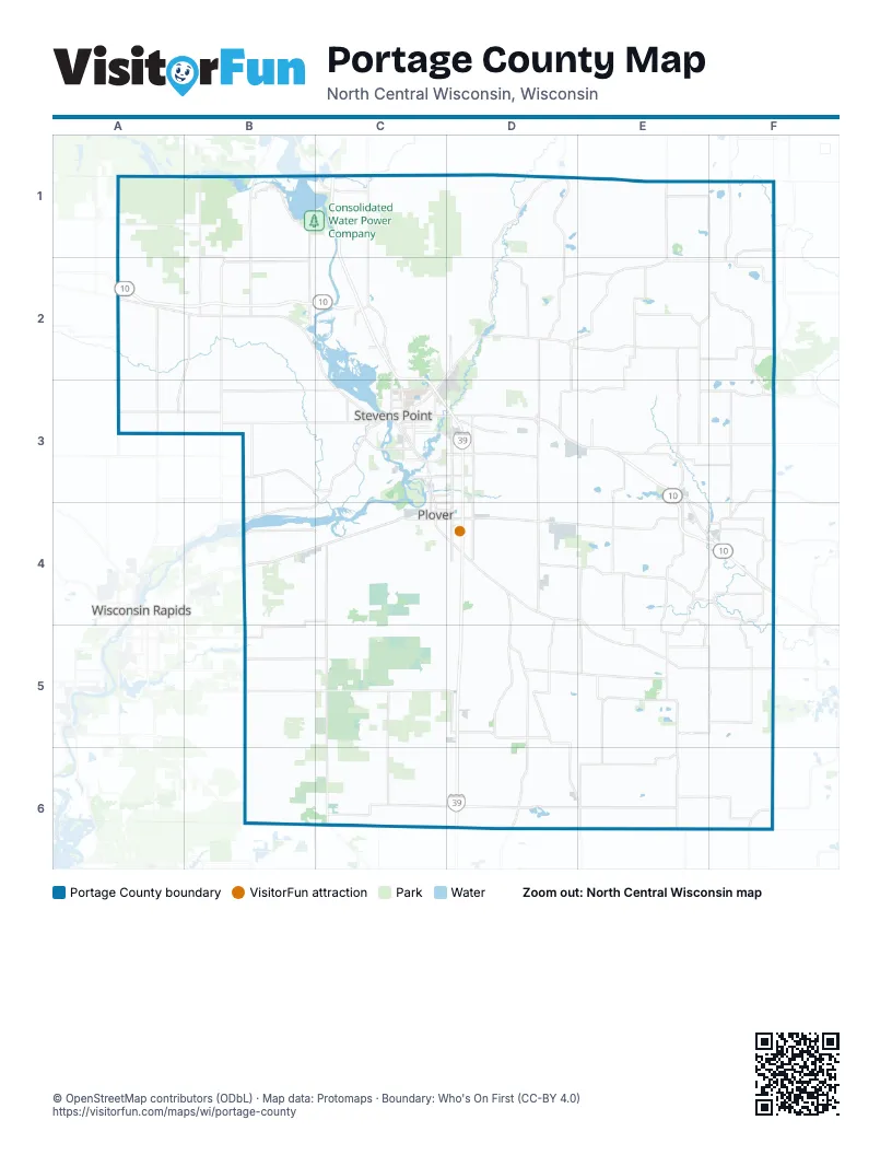
Maps inside Portage County
3 maps inside, from the street map of Portage County down.
City
Towns
Street index of Portage County
Each street on the sheet and the grid squares it crosses.
- US Highway 10A2, B2, C2, D3, E3, E4, F4
- Plover RoadB4, C4, D4
- State Highway 66D2, E2, C3, B4, C4
- Main StreetB2, C3, D3, E3, D5
- Post RoadC3, C4, D4
- State Highway 49F1, F2
- State Highway 34B1, B2
- County Highway PA2, B2
- State Highway 161E3, F3
- Water StreetE2, C3, E3
- Victory RoadA1, A2
- Clark StreetC3, D3
- State Highway 22F6
- Loberg RoadE3
- West Clark StreetC3
- State Highway 54D4
- Centerpoint DriveC3
- WI 34B2
- West Jackson StreetC3
- State Highway 134B2
- Vietnam War Veterans Memorial HighwayD3
- County Road DD4, E4, F4, E5, F5, C6, D6, E6
- County Road AE1, F1, E2, F2, E3, E4, F4, E5, E6
- County Road BF3, D4, E4, F4
- County Highway HHB2, C2, C3
- North 120th StreetC5, C6
- McDill AvenueC3, D3
- County Road AAE6, F6
- River View AvenueC3
- Brilowski RoadD3
- County Highway RD3, D4
- Church StreetB2, D2, E2, C3, D5, D6
- Division StreetC3, F4, D5, E6
- Eisenhower AvenueD4
- Stanley StreetC3
- Grand Avenue EastE2, F2
- West Grand AvenueC3
- Grand Avenue WestE2
- County Road JD1, D2, D3, D4, D5, D6, E6
- County Road KD2, D3, E3, E4, E5
- County Road TF2, F3, F4
- County Road WB5, C5, D5
- County Road IE1, E2, D3, E3
- County Road BBD4, D5, D6
- County Road ZD2, E2, F2
- County Road EEE4, E5, E6
- County Road QE3, E4, E5
- County Road YD1, D2
- Torun RoadD1, D2
- Old Highway 18D3, E3
- County Road EB1, B2, C3
- County Road CB3, C3
- County Road ND5, E5
- Elm RoadC5, C6
- 1st StreetE2, E3, D4, D5, D6
- County Road FC4, C5
- Hoover AvenueD3, D4
- Second Drive NorthC2, C3
- County Road K NorthD2
- County Road MA3, B3
- County Road GA2, B2, A3
- County Road ZZE2, E3
- County Road FFB4, C4, B5
- County Road PPB3, C3
- County Road JJD5
- County Road IIB3, B4
- County Road SSE3, F3
- County Road WWB5, C5
- County Road TTE5, F5
- 2nd StreetE2, E3, D4, E6
- County Road MME3, F3
- Central Sands RoadD5, D6
- Biron Drive EastB4, C4
- County Road OB2, B3
- North Point DriveC3, D3
- County Road OOE2
- County Road GGE5
- Buelow RoadF5
- Casimir RoadC2
- Hoover Avenue NorthD3
- County Road DBC1
- County Road VF4
- County Road J NorthD2, D3
- County Road CCD2, E2
- County Road NNF1, F2
- CTH OB1
- Fourth AvenueC3
- Michigan AvenueC3
- County Road DDF4
- Hoover RoadD3
- Lake DriveE3, B4
- Sky View RoadE3
- Patch StreetC3
- Porter RoadC3, D3
- Roosevelt DriveC4, D4
- County Road T SouthF3
- Okray AvenueC3, C4
- Jefferson StreetE2, C3, D3
- North Lakeview RoadF2
- School RoadE3, E4, F4, D5
- Plover Springs DriveC3, D3
- Maria DriveC3
- County Road A NorthE3
- Porter DriveD3
- Maple Bluff RoadD3
- County Road QQE3
- First StreetC3
- Dixon StreetC3
- Wisconsin AvenueC3, C4
- Sherman AvenueC3
- Whiting AvenueC3
- Country Club DriveD3
- Saddle Sore LaneC5, D5
- Second StreetC3
- Cedar DriveC4, D4
- Western WayE4
- Portage StreetC3, E6
- Tommy's TurnpikeC3
- Sawmill RoadC2
- North Main StreetE1, E2, F4
- County Road T NorthF3
- Mill StreetF4, D6, E6
- Nebel StreetC3
- Green AvenueC3
- Wilshire BoulevardC3
- South Main StreetE2, E4, F4
- Wisconsin StreetC3
- North AvenueB2
- Prentice Street NorthC3
- County Highway PPB3
- Chestnut DriveC4
- County Highway AAE6
- Industrial Park RoadC3, D3
- Green Avenue NorthC3
- County Highway JE6
- Pinecrest AvenueC3
- County Road K/ZD2
- West Limits RoadB2
- County Highway BBD6
- Akron AvenueC6, D6, E6, F6
- 2nd AvenueF4, C6, D6, E6, F6
- Birch DriveC1, D1, D3, B4, C4, D4
- 3rd AvenueF5, C6, D6, E6, F6
- Taft RoadC4, C5, C6
- Townline RoadC4, C5, C6
- Mill RoadE4, B5, C5, D5
- Tower RoadE4, B6, C6
- Lake RoadB1, E4, B5, C5
- River RoadC1, B2, C2, E3, E4, F4
- Deer RoadE2, D3, E3, E4, B5, C5, E5
- Oak StreetC3, E3, B6, C6, D6, E6
- 4th StreetD3, E3, D4, E4, E5, E6
- 5th AvenueD5, E5, F5, D6
- West River DriveC3, C4
- 5th StreetD3, E3, E6
- Isherwood RoadD4, D5
- Sunset DriveC1, C2, E2
- Old Amish RoadD4, E4
- Custer RoadD3, D4
- Town Line RoadB3, E3, E4, C6
- Prairie DriveD2, C4, D4
- Maple DriveC2, C4, D4, E5
- Shady DriveD4, D5
- 110th Street SouthB4, B5, B6
- Dewey DriveC2, D2
- Ridge RoadB2, C2, C3, E3, D4
- 100th Street SouthB4, B5
- 90th Street SouthB4, B5, B6
- Griffith AvenueB5, C5
- Rolling Hills RoadD3, E3
- Jordan RoadC2, D2
- Trestik RoadA2
- Kennedy AvenueD3, D4
- Pleasant DriveD4, E5
- 4th AvenueD5, E5
- Town Hall RoadB2, E3, D4
- Hay Meadow DriveC1, C2
- Harding RoadD5, D6
- Woodland RoadE1, E2, D3
- Willow Springs DriveC2, D2
- 3rd StreetE3, D5, D6, E6
- Wilderness DriveD1, E1
- 14th RoadE5, E6
- Long RoadB1, B2
- Pine StreetC3, C4, D5, B6, D6
- Bentley RoadD1, D2
- Quarry RoadB5, C5
- Evergreen AvenueC2, B6, C6
- 130th Street SouthC4, C5
- 6th StreetD3, E3
- Oakwood DriveC1
- Sunset Lake RoadF2, F3
- Coddington RoadC5, D5
- Merryland DriveD2, E2
- Maple RoadE1, B2, C2
- North Elm RoadB2, B3
- Trout Creek RoadE3, F3
- Oakdale DriveE5, F5
- Coolidge AvenueC4
- Elm StreetC3, D3, B4, D6, E6
- Pioneer RoadC2, D2
- Oak RoadF1, B3, E3, C6
- Krogwold RoadE2, F2
- Bluff RoadD3, D4, D5
- Forest DriveE3, C4
- Twin Lakes DriveD1, E1
- North Maple RoadB2, B3
- Tommorow River RoadF3, F4
- 16th RoadF5, F6
- White Pine RoadB2, F2
- Badger DriveF5
- North Reserve DriveC2
- Standing Rocks RoadD4, E4
- Washington StreetB4, C4, E4, F4
- Wilshire Boulevard NorthC2, C3
- Jackson AvenueC4
- Hotvedt RoadE3, F3
- Oak DriveE4, E5
- Isaacson RoadF3
- Bear Creek RoadB3
- Burbank RoadD1, D3
- River DriveE1, C4
- North Deer LaneC1, B2, B3
- Brilowski Road NorthD2, D3
- Swamp RoadC5
- Buena Vista DriveC5
- Old Wausau RoadC2, C3
- Ellis RoadD2
- Oak Hill RoadB2
- Eckels RoadD4, D5
- 110th Street NorthB4
- Meadow LaneD1, A2, C3, D4, E4
- Lake Emily RoadE3, E4
- Smokey RoadE3, E4
- Robin LaneC2, D2, C3, D3
- Minnesota AvenueC3
- Reserve Street NorthC2, C3
- Monroe AvenueC4
- Hoover Avenue SouthD4
- County Line DriveD1, E1
- Lake Thomas RoadD3, E3
- Pine RoadA2, B2
- Lime Lake RoadE4
- Fountain Grove RoadE4
- Marsh RoadB2, B3
- Lake Meyers RoadE3, F3
- Morgan RoadF4, E5, E6
- Granite Ridge RoadC2
- Five Corner RoadE3
- Patterson Lake RoadD5, E5
- 100th Street NorthB4
- 90th Street NorthB4
- Grant StreetC3, E4, B5, C5
- Washington AvenueE2, C3, C4
- Linwood DriveB3
- Evergreen DriveC2, E2, C4
- Sherman RoadD5, E5
- 15th RoadE6
- Fountain Lake AvenueF5
- Lincoln AvenueC3, C4, E6
- Corrigan RoadE5
- 95th Street SouthB4, B5, B6
- Buena Vista RoadB5, C5
- Bestul RoadF3
- 6th Street NorthE5
- Meehan DriveC4
- Grayson RoadE3
- Marsh DriveC4, D4
- Lauras LaneD6
- East Saumer RoadF1
- 90th StreetB6
- Stratton Lake RoadF5, F6
- Edgewood Road NorthE2, E3
- Farmers RoadC5, C6
- Ole River RoadB4, C4
- Robin RoadA2, B2
- Little Chicago RoadC3
- Music DriveD2
- Damrau RoadE4
- South Elm RoadB3
- Hayes AvenueC4
- North Merryland RoadD2, E2
- Stashek LaneA2
- Glenwood RoadB4
- Pavelski RoadE3
- Lone Elm RoadA2
- Brandl LaneA3
- Peterson RoadB1, B2
- North Star RoadD2
- Sandy RoadC1, C6, D6
- Ellis StreetC3, D3
- Wigwam RoadF1
- Birch RoadE1
- Heffron StreetC3, D3
- East Hamilton RoadE2
- Saint Adalberts RoadE2
- Hillcrest RoadE2
- Alm RoadE3, E4
- North Oak RoadB2, B3
- Otto RoadF4
Things to do on the Portage County map
Places on the map
- Almond
- Almond-Bancroft School Forest
- Amherst
- Amherst Junction
- Amherst Millpond 90
- Bass Lake
- Becker Lake Recreational Area
- Buena Vista Wildlife Area
- Bukolt Park
- Consolidated Park
- Consolidated Water Power Company
- Crossroads Commons
- Dewey Marsh Recreational Area
- Dewey Marsh Wildlife Area
- DuBay Park
- Fields Island
- Fogarty Marsh
- Iverson Park
- Jordan County Park
- Jordan Pond
- Junction City
- Lake Emily
- Lake Emily Park
- Lake Helen
- Lions Lake
- Lost Creek
- Lost Creek Wetland
- Mead Conifer Bogs State Natural Area
- Mead State Wildlife Area
- Nelsonville
- Park Ridge
- Plover River
- Portage County Business Park
- River's Edge Campground
- Rocky Run Preserve
- Rosholt
- Schmeeckle Reserve
- SentryWorld Golf Course
- Spring Lake
- Standing Rocks Park
Next to Portage County
© OpenStreetMap contributors, Open Database License, openstreetmap.org/copyright · Map data: Protomaps · Boundary: Who's On First (CC-BY 4.0); Quattroshapes (CC BY 2.0)















