

Wisconsin map
Town of Oshkosh map
About 67,242 people live here (Census Bureau, 2024 estimate). The sheet's index lists 99 streets; Brooks Road, County Road S and Green Valley Road cross the most grid squares. Also on it: Bare Bones Brewery, E.D. Chase Roofing and Fish Tales.
Open the map (PDF, US Letter)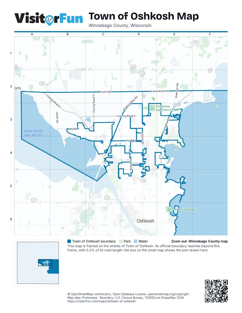
Street index of Town of Oshkosh
Each street on the sheet and the grid squares it crosses.
- Brooks RoadA2, B2, C2, D2
- Clover LaneA2
- County Road SA2, B2, B3, C3
- Fox StreetA2
- Ivy LaneA2
- Nickels DriveA2
- Primrose LaneA2
- Skeleton Bridge RoadA2
- Violet LaneA2
- Luebke RoadB2
- Wiouwash State Recreation TrailB2
- Clevedon LaneC2
- County Road TC2, C3
- St Ives RoadC2
- Green Valley RoadD2, C3, D3, C4
- Indian Point RoadD2, E2, F2
- Jackson StreetD2, D3, D4, D5
- Juniper LaneD2
- State Highway 76D2
- Tamarack TrailD2
- Tumblebrook DriveD2
- Bittersweet LaneE2
- British LaneE2
- County Road AE2, F2, E3, E4
- Island View DriveE2, F2, E3
- Sherman RoadE2, E3, E4
- Channel View DriveF2
- Chesapeake CourtF2
- I-Ah-Maytah RoadF2
- Killdeer LaneF2
- Indian Bend RoadA3
- Plummers Point RoadA3, B3
- Walden LaneA3, B3
- Andrew StreetB3, C3
- Edgewood LaneB3, B4
- Gray Wolf DriveB3
- Leach RoadB3
- Old Oak RoadB3
- Red Fox RoadB3
- Ryf RoadB3, C3
- Shangri-La Point RoadB3, B4
- West County Road YB3, C3, D3
- Kristine StreetC3
- Lake Butte des Morts DriveC3, C4
- Pip LaneC3
- Richards AvenueC3
- Roberts AvenueC3
- Schneider AvenueC3
- Sky Ranch AvenueC3
- Stearns DriveC3, C4
- Ulman StreetC3
- Courtland AvenueD3
- East County Road YD3, E3
- Glendale AvenueD3
- Kope AvenueD3
- Nielsen DriveD3
- Norton AvenueD3
- Showview LaneD3
- Western DriveD3
- Butler AvenueE3
- Cedar View DriveE3
- Island Estates CourtE3
- Pickett AvenueE3
- Sunnyview RoadE3
- Edgewood RoadB4
- Algoma BoulevardC4
- Basler LaneC4
- Bellaire LaneC4
- Glenway DriveC4
- Marine DriveC4
- Stillman DriveC4
- Sunset Point LaneC4
- US Highway 45C4
- Walter StreetC4
- West Fernau AvenueC4, D4
- West Snell RoadC4, D4
- Westwind RoadC4
- Anderson StreetD4
- Christian DriveD4
- Farmington AvenueD4
- Industrial AvenueD4
- Olson AvenueD4
- Vinland StreetD4, D5
- Zion StreetD4
- Bowen StreetE4
- Cozy LaneE4
- East Snell RoadE4
- Harbor Bay RoadE4
- Harrison StreetE4
- Macarthur RoadE4
- Miller LaneE4
- Nicolet AvenueE4, E5
- Shadow LaneE4
- Shorewood DriveE4
- Shorewood LaneE4
- Clover StreetC5
- West Packer AvenueC5, D5
- Park Ridge AvenueD5
- Hickory LaneE5
Places on the map
- Bare Bones Brewery
- E.D. Chase Roofing
- Fish Tales
- Gallinger Airport
- Hickory Oaks Campground
- Island Park
- Jaegers Island Wildlife Area
- Lake Butte des Morts
- Lake Winnebago
- McKay Garden Center
- Millers Bay
- Mobil
- Mobil Mart
- North Asylum Bay
- Plummer Cemetery
- South Asylum Bay
- Winnebago Post Office
- Winnebagoland BMX
Next to Town of Oshkosh
© OpenStreetMap contributors, Open Database License, openstreetmap.org/copyright · Map data: Protomaps · Boundary: U.S. Census Bureau, TIGER/Line Shapefiles 2024