

Wisconsin map
Wisconsin Rapids map
About 18,675 people live here (Census Bureau, 2024 estimate). The sheet's index lists 300 streets; 3rd Avenue South, 8th Street South and Lincoln Street cross the most grid squares. Also on it: Woodlands Business Center, Aspirus Riverview Hospital and Ben Hansen Park.
Open the map (PDF, US Letter)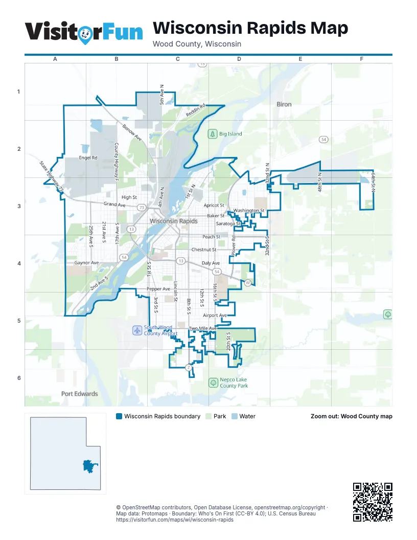
Street index of Wisconsin Rapids
Each street on the sheet and the grid squares it crosses.
- Plover RoadD2, D3, D4
- East Riverview ExpresswayB4, C4, D4
- 8th Street SouthC3, C4, C5, C6
- West Grand AvenueA3, B3, C3
- 2nd Avenue SouthC3, B4, A5
- West Riverview ExpresswayB3, C3, B4
- State Highway 73A2, A3
- Baker StreetC3, D3
- County Highway WD4
- Baker DriveC3, D3
- Griffith AvenueC6
- 8th Street NorthC3
- Lincoln StreetC3, C4, C5, C6
- 16th Street SouthD3, D4, D5
- Peach StreetC4, D4
- County Highway FB1, B2, B3
- Chestnut StreetC4, D4
- Two Mile AvenueC5, D5
- 3rd Street SouthC3, C4, C5
- Pepper AvenueB4, C4, D4
- 25th Avenue SouthB3, B4
- Chase StreetA3, B3, C3
- 1st Street SouthC4, C5
- Bonow AvenueB1, B2, C2
- 17th Avenue SouthB3, B4
- East Grand AvenueC3, D3
- Gaynor AvenueA4, B4
- 3rd Street NorthC2, D2, C3
- 16th Street NorthD3
- East Jackson StreetC3
- West Jackson StreetC3
- 32nd Street SouthD4
- Seneca RoadA5
- Wilson StreetC2
- Jackson StreetC3
- 1st Street NorthC2, D2, C3
- 12th Street SouthC3, C4, C5, C6
- Airport AvenueC5, D5
- 5th Avenue NorthC1, C2, C3
- 4th Street SouthC3, C4, C5
- Daly AvenueB4, C4, D4
- Washington StreetC3, D3
- 10th Street SouthC3, C4, C5
- Oak StreetC3, D3, D4
- 14th Street SouthC3, C4, D5
- Grove AvenueC5, D5
- 2nd Street SouthC3, C4, C5
- Saratoga StreetC3, D3
- 11th Street SouthC3, C4, C5, C6
- 20th Street SouthD3, D4, D5, D6
- Sampson StreetC4, C5
- High StreetB3, C3
- 21st Avenue SouthB3, B4
- 15th Street SouthD3, D4, D5
- Franklin StreetC3, D3, E3
- 9th Street SouthC3, C4, C5, C6
- 5th Street SouthC4, C5
- 48th Street NorthE2, E3
- 64th Street NorthF3
- 6th Street SouthC3, C4, C5
- Reddin RoadC1, C2
- Dewey StreetC4
- Engel RoadA2, B2
- Apricot StreetC3, D3
- 7th Street SouthC3, C4, C5
- Cook AvenueC5, D5
- Whitrock AvenueC5, D5
- Alton StreetB3
- Clyde AvenueC5, D5
- 18th Avenue SouthB3, B4
- 2nd Street NorthC2, D2, C3
- Industrial StreetA3, B3
- Spring StreetC3, D3
- 32nd Street NorthD3
- East G StreetC4, D4
- Apple StreetC4, D4
- Boles StreetA4, B4
- 19th Avenue SouthB3, B4
- Norton StreetC3, D3
- 10th Avenue NorthB2, B3
- Kingston RoadD3, E3
- 22nd Avenue SouthB3, B4
- 13th Street SouthC3, C4, C5
- Carey StreetA4, B4
- 28th Street NorthD3
- Elm StreetC3, C4
- Jefferson StreetA2, B2
- 26th Street NorthD2, D3
- Cliff StreetC4, C5
- 1st Avenue SouthB3, C3, B4
- 17th Street NorthD3
- 20th Avenue SouthB3, B4
- Miller AvenueC4
- Avon StreetC3, D3
- 3rd Avenue SouthB3, C3, A4, B4, A5
- Prospect StreetC3, D3
- Taylor AvenueC4
- Fremont StreetB3, C3
- Goodnow AvenueC4
- 14th Street NorthC3, D3
- 4th Avenue NorthC3
- Wisconsin StreetC3, D3
- Mc Kinley StreetB3, C3
- Wood AvenueC4
- 13th Street NorthC3
- Strodman AvenueC4
- 23rd Avenue SouthB3, B4
- 11th Avenue NorthB2, B3
- Wylie StreetC3, D3
- 24th Avenue SouthB3, B4
- Township AvenueC5, D5
- 23rd Street NorthD3
- 17th Street SouthD4
- Irving StreetC3, D3
- 12th Street NorthC3
- Mead StreetC4
- Rosecrans StreetB2, B3
- 13th Avenue SouthB3, B4
- 15th Street NorthD3
- Clark StreetB3
- Brown StreetB2, C2
- 24th Street SouthD3, D4, D5
- Woodland DriveC5
- Shady LaneC5
- Piltz AvenueC4
- 11th Street NorthC3
- Riverwood LaneB4
- Commerce DriveE2
- 19th Street SouthD4
- 29th Avenue NorthA2, A3
- Huntington AvenueC5, D5
- 25th AvenueB2, B3
- Sweat AvenueC5, D5
- 27th Avenue SouthA3, A4, B4
- 5th Street NorthC3, D3
- 18th Street NorthD3
- 29th Avenue SouthA4
- George RoadA3
- 23rd Avenue NorthB2, B3
- 10th Street NorthC3
- 22nd Street NorthD3
- Garfield StreetC3, C4
- Rapids StreetC4
- Nash RoadB2, C2
- Russell StreetB4
- Hale StreetB3, C3
- 25th Avenue NorthB3
- Witter StreetC3, C4
- Hill StreetC4
- 9th Avenue NorthB2, B3
- Riverview DriveC2, C3
- 10th Avenue SouthB3, B4
- 9th Street NorthC3
- Pear StreetC4, D4
- Canal StreetB3
- Amundson StreetD3
- Wyatt AvenueC4
- 12th Avenue NorthB3
- 21st Avenue NorthB2, B3
- Dura Beauty LaneB3, C3
- 13th Avenue NorthB3
- Glenwood HeightsC5
- 8th Avenue NorthB3, C3
- 14th Avenue SouthB3
- Ridgeview LaneD5, D6
- 18th Street SouthD4, D5
- North AvenueC1
- 19th Street NorthD3
- 14th Avenue NorthB3
- 20th Street NorthD3
- Birch StreetC3, C4
- 12th Avenue SouthB3
- Gardner StreetB3, C3
- Wolosek AvenueE2
- Smith StreetC2, C3
- State StreetC4, C5
- 21st AvenueB2
- 15th Avenue NorthB3
- 4th Street NorthD2, C3, D3
- Green Bay StreetB3
- Corey AvenueC5, D5
- 16th Avenue SouthB3
- 21st Street NorthD3
- Washington SchoolD3
- Wickham AvenueB4
- Maple Manor DriveC6
- Port StreetC4, C5
- Vanburen StreetB3, C3
- Blue Violet LaneC5, D5
- Ash StreetC2, D2, D3
- 16th Avenue NorthB3
- 26th Avenue SouthB3, B4
- 6th AvenueC2, C3
- Brickyard RoadB1
- Kuhn AvenueC6, D6
- Lyons StreetB4
- Maple StreetC3, C4
- Lake AvenueD4
- Rosewood AvenueC5, D5
- 24th Street NorthD3
- 23rd Street SouthD4
- Plover StreetC3
- 18th Avenue NorthB3
- Ruby AvenueC6
- 7th Street NorthC3
- 25th Street NorthD3
- 21st Place SouthD5
- 31st Street NorthD3
- Grape StreetC4
- Essex StreetB3
- Plum StreetC4, D4
- 28th Avenue SouthA4
- Sparks AvenueC5
- Engler DriveA4, B4
- 5th AvenueC2
- Goggins StreetB3, C3
- Condo DriveA2
- Lee StreetC4, D4
- Peterson AvenueC6
- Rainbow DriveB2, C2, C3
- Weeping Willow DriveC5
- Monroe StreetC3, D3
- Pleasant View DriveD2, D3
- Metcalf PlaceD4
- Dove AvenueC5
- Snyder StreetD4
- Travis DriveA4
- 19th Avenue NorthB3
- 6th Avenue NorthC2, C3
- Cherry StreetC2, C3
- Poplar StreetC2, C3, D3
- Pine StreetC3, C4
- Mohawk StreetA2
- 8th Avenue SouthB3
- Strawberry LaneD2
- Boles CircleA4, B4
- Pioneer RoadA4
- Case AvenueC4
- Crocket LaneA4
- Harrison StreetB3, C3
- Bridle PathB4
- Spencer StreetA4, B4
- Bassett PlaceD4
- Boone CircleA4
- 14th Place SouthC5, C6
- Hurley StreetA5
- Broadway StreetC3
- Drake StreetC3
- Lily LaneC4, D4
- 7th Avenue NorthC3
- 11th Avenue SouthB3, B4
- Shorewood TerraceD2, D3
- 9th Avenue SouthB3
- Brianwood AvenueC6
- 15th Place SouthD5, D6
- Woodbine StreetB4
- Walnut StreetC3, C4
- Market StreetC3
- Edgewood PlaceC1
- Pine AvenueC5
- Thalacker AvenueC5
- Park AvenueB4
- Blue Heron LaneB4
- Spruce StreetC4
- James CourtC4, D4
- Johnson StreetC3
- 7th Avenue SouthC3
- River Ridge RoadB4, C4
- 17th Avenue NorthB1
- Cleveland StreetB2
- Daffodil DriveC5, D5
- Yard EntranceC2
- Menominee StreetA2
- 20th PlaceD4
- Ridgeview CourtD6
- Railroad StreetC3
- 29th Street NorthD3
- Davis AvenueC4
- 30th Street NorthD3
- 27th Street NorthD3
- Court StreetC4, C5
- Deer AvenueA2
- Lavigne StreetC3
- 28th Street SouthD4
- Blue Iris CourtC5
- Evergreen LaneD3
- Webb AvenueC5
- Locust StreetC3, C4
- Love StreetC3
- Sherman StreetC4
- Sherri LaneC4
- Madison StreetC4
- 25th PlaceD3
- 3rd Avenue NorthC3
- 6th Street NorthC3
- Carriage CourtB4
- Butler StreetB3
- 15th Avenue SouthB3
- Dale StreetC4
- Sherwood CourtD5
Places on the map
- 1st Choice Automotive Repair
- 27th Avenue South
- A1 Economy Roofing
- Advance Auto Parts
- ALDI
- AmericInn
- Applebee's
- Aspirus Doctors Clinic
- Aspirus Riverview Hospital
- Assumption High School
- Auto Pro Repair
- Baker Street Community Church
- Baltus Bread & Butter
- Ben Hansen Park
- Bowlmor Lanes
- Boys and Girls Club
- Calvary Cemetery
- Central Wisconsin BMX
- Edwards Island
- Forest Hill Cemetery
- Garrison Island
- Gaynor Park
- Howe Elementary School
- Legion Park
- Lincoln High School
- Lyon Park
- McMillian Memorial Library
- Mead Athletic Field
- Robinson Park
- South Wood County 2000 Field
- The UPS Store
- Walmart Supercenter
- Wisconsin National Guard
- Wisconsin Rapids City Hall
- Wisconsin Rapids Municipal Zoo
- Wisconsin Rapids Post Office
- Witter Park
- Woodlands Business Center
Next to Wisconsin Rapids
- Biron
- Port Edwards
© OpenStreetMap contributors, Open Database License, openstreetmap.org/copyright · Map data: Protomaps · Boundary: Who's On First (CC-BY 4.0); U.S. Census Bureau















