

West Virginia road map
I-64 in West Virginia map
I-64 is about 171 miles in West Virginia. It has 55 exits, from Exit 1 at mile 1 to Exit 183 at mile 171. It meets 26 highways; US 60, WV 25 and US 19 meet it in the most grid squares.
Open the map (PDF, US Letter)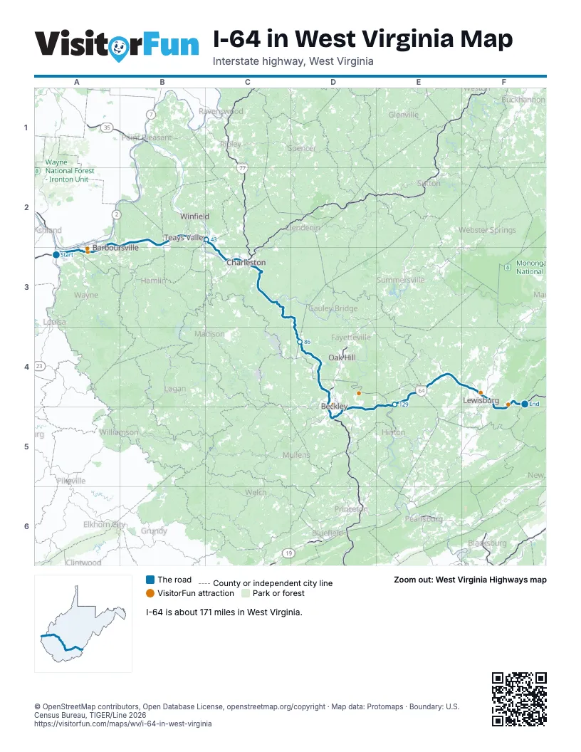
Exits on I-64 in West Virginia
Each exit in mile order, with its grid square.
- Exit 1mile 1, A3
- Exit 8mile 7, A3
- Exit 11mile 10, A3
- Exit 15mile 13, A3
- Exit 18mile 17, A2
- Exit 20Amile 18, A2
- Exit 20Bmile 19, B2
- Exit 20mile 19, B2
- Exit 28mile 26, B2
- Exit 34mile 33, B2
- Exit 39mile 37, B2
- Exit 40mile 39, B2
- Exit Exit 45mile 43, C2
- Exit 47Amile 46, C2
- Exit 47Bmile 46, C2
- Exit 47mile 46, C2
- Exit 50mile 48, C3
- Exit 53mile 51, C3
- Exit 55mile 53, C3
- Exit 56mile 53, C3
- Exit 58Amile 55, C3
- Exit 58Bmile 56, C3
- Exit 58Cmile 56, C3
- Exit 100mile 57, C3
- Exit 99mile 58, C3
- Exit 98mile 59, C3
- Exit 97mile 60, C3
- Exit 96mile 61, C3
- Exit 95mile 61, C3
- Exit 89mile 66, C3
- Exit 85mile 71, C3
- Exit 79mile 75, C3
- Exit 74mile 80, D3
- Exit 66mile 87, D4
- Exit 60mile 93, D4
- Exit 54mile 97, D4
- Exit 45mile 105, D4
- Exit 44mile 107, D4
- Exit 42mile 109, D5
- Exit 124mile 115, D5
- Exit 125Amile 115, D5
- Exit 125Bmile 115, D5
- Exit 125mile 116, D5
- Exit 129Amile 118, D5
- Exit 129Bmile 119, D5
- Exit 129mile 119, D5
- Exit 133mile 123, D5
- Exit 139mile 129, E4
- Exit 143mile 133, E4
- Exit 150mile 139, E4
- Exit 156mile 146, E4
- Exit 161mile 151, F4
- Exit 169mile 159, F4
- Exit 175mile 164, F5
- Exit 183mile 171, F4
Highways I-64 meets
Each highway it meets and the grid squares where they meet.
- US 52A3
- WV 75A3
- US 60A2, A3, C3, E4, F4, F5
- WV 152A3
- WV 527A3
- WV 10A3
- WV 193A2
- WV 34B2
- US 35B2
- WV 817B2
- WV 25C2, C3
- WV 622C2
- WV 601C3
- WV 61C3
- US 119C3
- I-77C3
- WV 114C3
- WV 94C3
- WV 612D4
- US 19D4, D5
- WV 3D4, D5
- WV 16D5
- WV 20E4
- WV 12F4
- US 219F4
- WV 311F4
Towns along I-64 in West Virginia
In mile order, with the grid square of each.
- Kenovamile 0, A3
- Ceredomile 1, A3
- Huntingtonmile 4, A3
- Barboursvillemile 14, A2
- Pea Ridgemile 14, A2
- Miltonmile 24, B2
- Cullodenmile 28, B2
- Hurricanemile 32, B2
- Teays Valleymile 34, B2
- Nitromile 43, C2
- Pocamile 43, C2
- Cross Lanesmile 45, C2
- Jeffersonmile 48, C3
- Dunbarmile 50, C3
- South Charlestonmile 50, C3
- Charlestonmile 52, C3
- Coal Forkmile 61, C3
- Marmetmile 65, C3
- Chesapeakemile 67, C3
- Chelyanmile 71, C3
- Shrewsburymile 72, C3
- Paxmile 97, D4
- Bradleymile 102, D4
- Prosperitymile 104, D4
- Beckleymile 105, D4
- Mabscottmile 108, D5
- MacArthurmile 109, D5
- Crab Orchardmile 109, D5
- Beavermile 112, D5
- Raleighmile 113, D5
- Danielsmile 114, D5
- Lewisburgmile 158, F4
- White Sulphur Springsmile 164, F5
Things to do on the I-64 in West Virginia map
© OpenStreetMap contributors, Open Database License, openstreetmap.org/copyright · Map data: Protomaps · Boundary: U.S. Census Bureau, TIGER/Line 2026