

West Virginia road map
I-79 in West Virginia map
I-79 is about 149 miles in West Virginia. It has 35 exits, from Exit 104 at mile 0 to Exit 155 at mile 143. It meets 20 highways; US 119, US 19 and WV 4 meet it in the most grid squares.
Open the map (PDF, US Letter)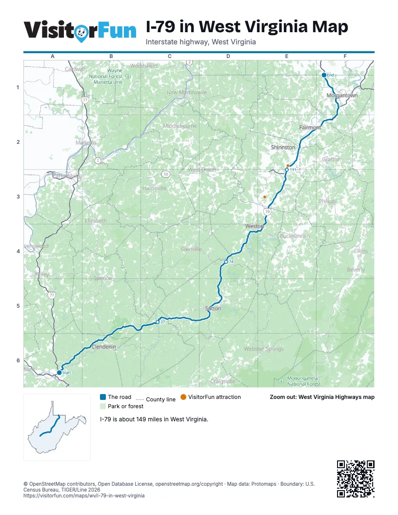
Exits on I-79 in West Virginia
Each exit in mile order, with its grid square.
- Exit 104mile 0, A6
- Exit 5mile 4, A6
- Exit 9mile 9, A6
- Exit 19mile 18, B6
- Exit 25mile 23, B5
- Exit 34mile 31, B5
- Exit 40mile 36, C5
- Exit 46mile 42, C5
- Exit 51mile 47, C5
- Exit 57mile 52, D5
- Exit 62mile 56, D5
- Exit 67mile 61, D5
- Exit 79mile 72, D4
- Exit 91mile 83, D4
- Exit 96mile 88, D4
- Exit 99mile 91, E4
- Exit 105mile 96, E3
- Exit 110mile 101, E3
- Exit 115mile 106, E3
- Exit 117mile 108, E3
- Exit 119mile 110, E3
- Exit 121mile 112, E2
- Exit 124mile 114, E2
- Exit 125mile 115, E2
- Exit 132mile 122, E2
- Exit 133mile 123, E2
- Exit 135mile 125, E2
- Exit 136mile 126, E2
- Exit 137mile 127, E2
- Exit 139mile 129, F2
- Exit 146mile 135, F2
- Exit 148mile 138, F1
- Exit 152mile 142, F1
- Exit 153mile 142, F1
- Exit 155mile 143, F1
Highways I-79 meets
Each highway it meets and the grid squares where they meet.
- I-77A6
- US 119A6, B6, E4
- WV 114A6
- WV 36B5
- WV 16C5
- WV 4C5, D5
- US 19D4, D5, F1
- WV 5D4
- US 33E4
- US 48E4
- WV 270E3
- WV 20E3
- WV 58E3
- US 50E3
- WV 279E2
- WV 131E2
- US 250E2
- WV 73E2
- WV 310E2
- WV 7F1
Towns along I-79 in West Virginia
In mile order, with the grid square of each.
- Charlestonmile 0, A6
- Big Chimneymile 4, A6
- Suttonmile 57, D5
- Flatwoodsmile 62, D5
- Burnsvillemile 72, D4
- Westonmile 88, D4
- Jane Lewmile 96, E3
- Lost Creekmile 100, E3
- Stonewoodmile 107, E3
- Anmooremile 108, E3
- Clarksburgmile 109, E3
- East Viewmile 109, E3
- Despardmile 110, E3
- Bridgeportmile 110, E3
- White Hallmile 121, E2
- Pleasant Valleymile 123, E2
- Fairmontmile 123, E2
- Morgantownmile 138, F1
- Westovermile 141, F1
- Granvillemile 142, F1
- Star Citymile 143, F1
- Cassvillemile 145, F1
Things to do on the I-79 in West Virginia map
© OpenStreetMap contributors, Open Database License, openstreetmap.org/copyright · Map data: Protomaps · Boundary: U.S. Census Bureau, TIGER/Line 2026