

West Virginia map
Jefferson County map
About 61,264 people live here (Census Bureau, 2024 estimate). The sheet's index lists 300 streets; Charles Town Road, Leetown Road and Summit Point Road cross the most grid squares. Things to do inside the boundary: Devil's Due Distillery, Harpers Ferry National Historical Park and Hollywood Casino at Charles Town Races.
Open the map (PDF, US Letter)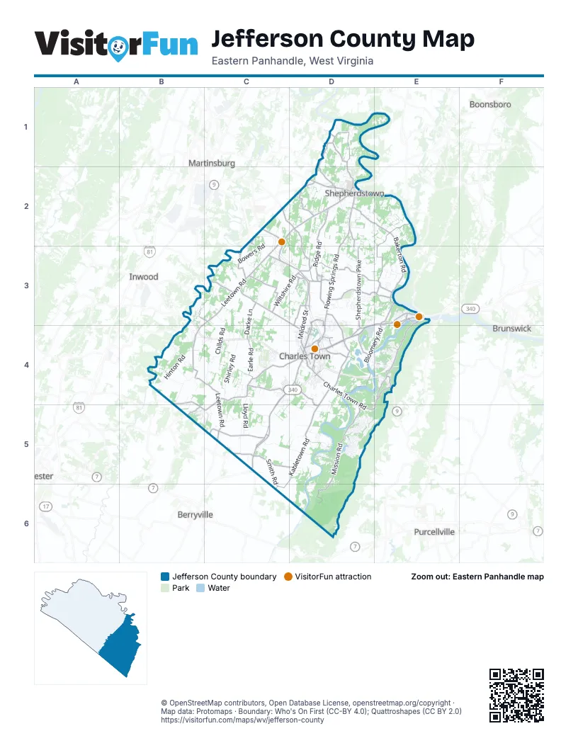
Street index of Jefferson County
Each street on the sheet and the grid squares it crosses.
- Frank Buckles ParkwayC2, C3, D3, D4
- Leetown RoadC2, C3, B4, C4, C5
- William L. Wilson FreewayD3, E3, D4
- Shepherdstown PikeD2, D3, D4
- Berryville PikeC4, D4, C5
- Kearneysville PikeC2, D2
- East Washington StreetD2, D4
- North Mildred StreetD3, D4
- Martinsburg PikeD2
- Currie RoadD3, D4
- South George StreetD4
- South Fairfax BoulevardD4
- West Washington StreetD2, D4
- South Mildred StreetD4
- North George StreetD4
- Hillside DriveD4
- North Duke StreetD2
- South Duke StreetD2
- West German StreetD2
- Martin Luther King BoulevardD4
- Lancaster CircleD4
- Lord Fairfax HighwayC5
- Charles Town RoadC2, C3, D3, D4, E4, D5, E5
- Summit Point RoadB4, C4, D4, B5, C5
- Flowing Springs RoadD2, D3, D4
- Chestnut Hill RoadE3, E4
- Wiltshire RoadC3, D3
- War Admiral BoulevardD3
- Augustine AvenueD4
- Sulphur Springs RoadC3
- Washington StreetE3
- East 5th AvenueD4
- Mountain Laurel BoulevardD4
- Hardesty RoadB5
- Potomac Farms DriveD2
- Shenandoah StreetE3
- High StreetE3, D4
- East German StreetD2
- South West StreetD4
- South Princess StreetD2
- Chestnut HillE4
- Old Charles Town RoadE4, B5
- Mission RoadD5, D6
- Kabletown RoadD4, C5, D5, C6
- Engle Molers RoadD2, E2, E3
- Bakerton RoadE2, E3
- Bloomery RoadE3, D4, E4
- Ridge RoadD2, D3
- Shepherd Grade RoadD1, D2
- Leetown PikeC3, D3, D4
- Withers & Larue RoadC5
- Warm Springs RoadD2, D3
- North Fairfax BoulevardD3, D4
- Hite RoadC3
- Smith RoadC5, C6
- Huyett RoadC4, D4
- Earle RoadC4
- Cattail Run RoadD4
- Scrabble RoadD1
- Luther Jones RoadD3
- Paynes Ford RoadC3
- Keyes Ferry RoadD4, E4
- Darke LaneC3, C4
- Persimmon LaneD2, E4
- Engle Switch RoadD3, E3
- Country Club RoadD3, D4
- Job Corps RoadD3
- Turner RoadD1, D2
- Old Cave RoadD4, D5
- Melvin RoadD3
- Knott RoadE2
- Daniel RoadD3
- Rippon Village DriveC5
- Hostler RoadE4
- Billmyer Mill RoadD2
- Shoreline DriveE3, E4
- Clipp RoadC5, D5
- Shenandoah Junction RoadD3
- Van Clevesville RoadC2, D2
- Lewisville RoadC5
- Blair RoadD4
- Halltown RoadD3, D4
- Kidwiler RoadD3, E3
- Harry Shirley RoadB3, C3
- Oak Lee DriveD3, D4
- Somerset BoulevardD4
- Jefferson AvenueD4
- Best RoadE3
- Border RoadC3
- Marlowe RoadD4
- Winebrenner RoadD2
- McGarry BoulevardD3
- Old Martinsburg RoadD2
- Patrick Henry WayD4
- West Burr BoulevardD3
- 16th AvenueD4
- Potomac AvenueD3
- Foal StreetD4
- Queen StreetB4
- 4th StreetD3, D4
- Cave RoadD4
- Stratus DriveC2
- Coast Guard DriveC2
- Zion RoadC3
- Park Service RoadE3
- Union StreetE3
- Cirrus WayC2
- Bakerton StreetE3, D4
- 18th AvenueD4
- Old Leetown PikeC3
- Rippon Commons CourtC5
- Blair Quarry RoadD4
- Pacesetter WayD4
- Glenwood LaneC5
- Briar Run DriveD4
- Golf Course RoadC2
- State Line RoadB4
- Shepherds Mill RoadC5
- Withers Larue RoadC5
- Swan Pond RoadD2
- River RoadD2, E2
- Bowers RoadC2, C3
- Shirley RoadC4
- Trough RoadD2, E2
- Hinton RoadB4
- South Childs RoadC4
- Opequon DriveB3, B4
- Terrapin Neck RoadD1, E1
- Brucetown RoadB4
- Myerstown RoadC5, D5
- Lloyd RoadC4, C5
- Shennandoah CircuitB5
- Box Factory RoadB4
- Wide Horizon BoulevardB3, C3
- Mt Hammond LaneD5
- Summit Point CircuitB5, C5
- Shenandoah River DriveD5
- Gardners LaneD2
- North Childs RoadC3, C4
- Johnnycake LaneD5
- Rolling LaneD5
- Valley View DriveE4, D5
- Patriots WayD6
- Cloverdale RoadC4, D4, C5
- Shenandoah DriveE3, C4, D4, E4
- Carter AvenueE3
- Avon Bend RoadD5
- Wilt RoadD4
- Huckleberry LaneD5
- Duncan RoadE2
- Wheatland RoadC5
- Morgan Grove RoadD2
- French RoadD3
- Uvilla RoadD3, E3
- Cherry Meade RoadB4
- Upper Loop RoadD1, E1
- Eagle's Nest LaneD5
- Whitmer RoadD3
- Cranes LaneC4, D4
- John Brown Farm RoadD5
- Pembroke WayC4
- Archer RoadC3
- Beallair Manor DriveD3, D4
- Prospect Hill BoulevardC4, D4
- Jefferson Orchard RoadC3
- Edgewood School RoadD2
- Lord Fairfax StreetC4
- General Rogers RoadD5
- Northport AvenueC3, D3
- Shannondale RoadD5
- Wildrose LaneD5
- Gingerbread LaneD5
- Candlewood DriveD4
- Stone Ridge RoadD5
- Deer Mountain DriveE3
- Willowdale DriveD2
- Wrens View LaneD5, E5
- FranklintownC5
- Amber LaneC4
- Red Maple LaneE4
- Gruber RoadB4
- Meadowland DriveC4
- Lower Clubhouse DriveD5
- Roper North Fork RoadC5, D5
- Hollywood DriveD4
- Jefferson CircuitB5, C5
- Woodbury DriveC3
- Chickamauga DriveD3, D4
- Bunny LaneD5
- Training Campus RoadC5
- Marsh Hawk WayD2
- Mountain Top TrailE4
- Wagon Trail RoadE4
- Waterside DriveD4
- Skyline TrailD5
- Barksdale DriveD4
- Prospect AvenueD2, E3, D4
- Cherry Run RoadE3
- King Lear DriveD5
- River Haven DriveD5
- Eastland DriveD4
- Country Club DriveE4
- Ann Lewis RoadD5
- Wren LaneD5, E5
- Cedar LaneB3, C3, E4
- Willingham RoadC3, C4
- Declaration DriveC4
- Deerfield DriveD1, C4
- Mason DriveE3
- Jenkins Hill RoadC5
- Lower Loop RoadD1, E1
- Cedar DriveB3, B4
- Citizens WayD4
- James Burr BoulevardD3
- Vance RoadE2
- Red Bird LaneD5
- Bunk House RoadC3
- Crosswinds DriveD4
- Morgana DriveD2
- Sawgrass DriveC4
- South Samuel StreetD4
- Fruit Hill LaneD2
- Pheasant Hill RoadC5
- Quail Run RoadC5, D5
- Dutch LaneD5
- Dogwood LaneD2, E4, D5
- Oregon TrailD3
- Elk Run DriveE3
- Peace Ridge RoadE3
- State Route 9B4
- Strider RoadC3
- 1st StreetC3, D3
- Duncan Field LaneD3
- Skid Pad RoadC5
- Spruce Hill WayC4
- University DriveD2
- Mission Ridge DriveD4, D5
- Shade Tree LaneD3
- Cynara LaneE3
- Orchard Lodge LaneD3
- Opequon LaneB3
- Willow Spring DriveD4
- Howard Farm RoadD1, D2
- Apple Cross RoadD3
- Sycamore RoadE4
- South Church StreetD2, D4
- Stonewall Estates RoadD3, E3
- Shepherd LaneD2
- Green Hill Farm LaneD2
- General Early DriveD3
- Lakeside Drive WestD5
- Conservation WayD1
- Shipley School RoadD3, E3, D4
- Robert C Byrd DriveD4
- FLOC WayD6
- Breckenridge WayD3
- Stubbs RoadC2, C3
- Acorn CircleD3
- Grubertown LaneB4
- Mara Rose LaneD3
- Leisure WayD1
- Hawthorne Dale RoadD5
- Old Shenandale RoadD5
- Stratford LaneD5
- Reynard RoadC3
- Multnomah LaneD5, D6
- Grouse LaneC5, D5
- Gap View BoulevardD3
- Cub Run LaneD5
- Turnberry DriveC4
- Fernbank DriveD2
- Cherry Hill Farm DriveB4
- Saint Andrews DriveC4
- Logie LaneC2
- Revenoor RoadD5
- Sylvan LaneD5
- Kryskerry WayD3
- Tuscawilla DriveC4
- Quinn Lea RoadD2, E2, E3
- Lakeside Drive SouthD5
- Stafford LaneD3
- Pack Horse LaneC5
- Rudder RoadD2
- Keyes Gap RoadE4
- Adelaide CircleD5, D6
- John Rissler RoadD4, D5
- Jefferson Circuit RoadB5, C5
- Wild Turkey RoadD5
- Paulas CircleB4
- Maple LaneE4
- Staley DriveD1
- Thumper DriveD3
- Rion Farm LaneD4
- Gray Fox RoadD5
- Bedford DriveD5
- Maddex Farm DriveD2
- Writt RoadE2
- Old Furnace RoadE3
- Riverside DriveD6
- Claymont Mansion RdC4
Things to do on the Jefferson County map
Places on the map
- Bavarian Inn
- Bolivar
- Charles Town
- Charles Town Plaza
- Cool Spring Preserve
- Cress Creek Country Club Golf Course
- Harpers Ferry
- Harpers Ferry Jobs Corps
- Harpers Ferry National Historical Park
- Jefferson Circuit
- Jefferson County Fairgrounds
- Jefferson Crossing
- Jefferson High School
- Keystone Quarries
- Lake Shannondale
- Leetown Science Center
- Locust Hill Golf Course
- Marketplace at Potomac Towne Center
- Middleway
- Moulton Park
- Murphy-Chambers Farm
- Needwood Farm Airport
- Potomack Canal
- Ranson
- Rolling Ridge Conservancy
- Sam Michaels Park
- Shannondale
- Shannondale Springs Wildlife Management Area
- Shenandoah Junction
- Shennandoah Circuit
- Shepherd University
- Shepherdstown
- Sleepy Hollow Golf and Country Club
- Somerset Village
- South Jefferson Park
- Summit Point Circuit
- Summit Point Motorsports Park
- Wildwood Middle School
- Willingham Knolls Park
- Windmill Crossing
Next to Jefferson County
- Berryville
- Boonsboro
- Brunswick
- Inwood
- Martinsburg
- Purcellville
© OpenStreetMap contributors, Open Database License, openstreetmap.org/copyright · Map data: Protomaps · Boundary: Who's On First (CC-BY 4.0); Quattroshapes (CC BY 2.0)