

Wyoming map
Campbell County map
About 47,946 people live here (Census Bureau, 2024 estimate). The sheet's index lists 300 streets; Highway 50, North US Highway 14-16 and Echeta Road cross the most grid squares. Things to do inside the boundary: Rockpile Museum.
Open the map (PDF, US Letter)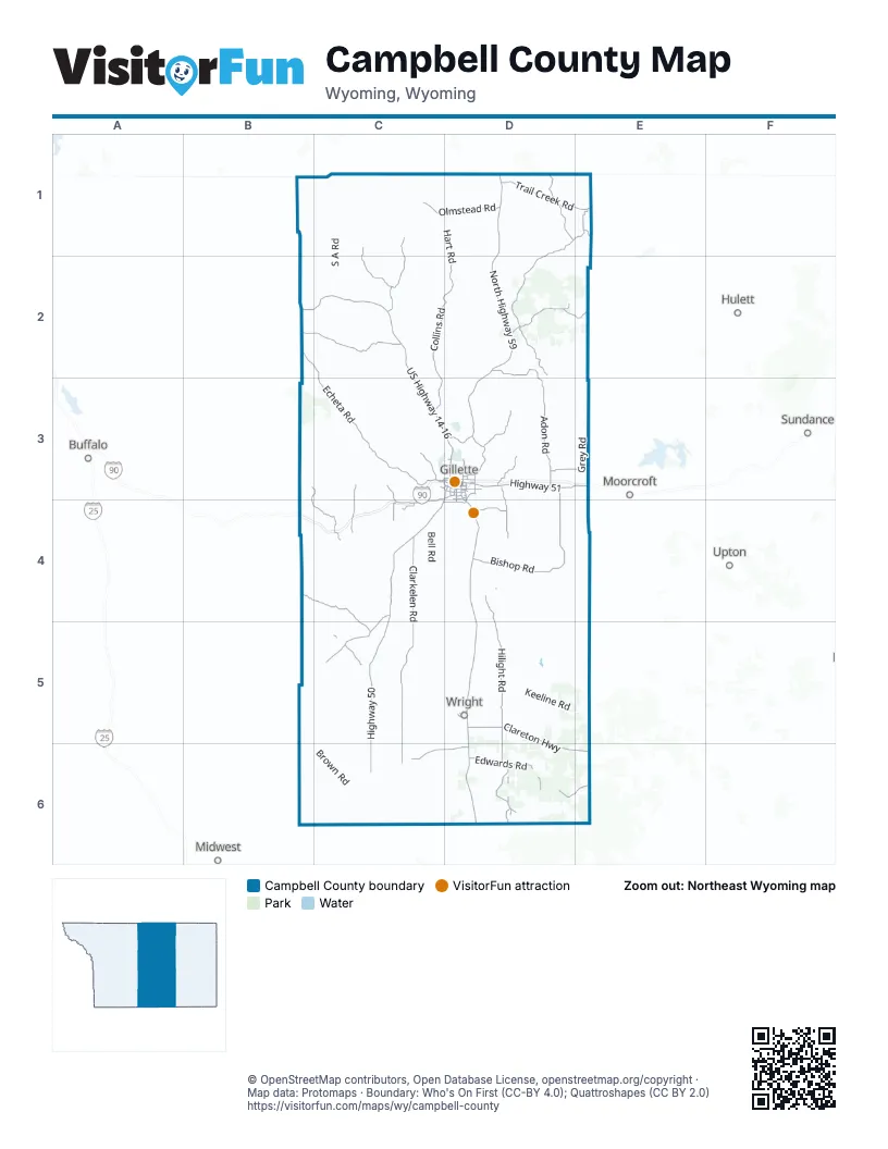
Maps inside Campbell County
1 map inside, from the street map of Campbell County down.
Street index of Campbell County
Each street on the sheet and the grid squares it crosses.
- State Highway 59 SouthD4, D5, D6
- North Highway 59D1, D2, D3
- Highway 50D3, C4, D4, C5, C6
- North US Highway 14-16B2, C2, C3, D3
- Clareton HighwayD5, D6, E6
- North Garner Lake RoadD3
- South Douglas HighwayD3, D4
- South Garner Lake RoadD3, D4
- East US Highway 14-16D3
- Skyline DriveD3
- West Southern DriveC4, D4
- East Southern DriveD4
- East 2nd StreetD3
- West 2nd StreetD3
- Highway 450E6
- Highway 51D3, E3
- Northern DriveD3
- East Boxelder RoadD3
- Butler-Spaeth RoadD3, D4
- West Boxelder RoadD3
- West 4-J RoadD3
- West Lakeway RoadD3
- South 4-J RoadD3
- Enzi DriveD3, D4
- East Lakeway RoadD3
- 4-J RoadD3
- Airport RoadD3
- State Highway 51E3
- Clarkelen RoadC4, C5, C6
- Echeta RoadB2, C2, C3, D3
- Hilight RoadD4, D5, D6
- Bishop RoadD3, D4
- Rocky Point RoadD1, E1, D2
- Collins RoadC2, D2, C3
- Black and Yellow RoadC4, C5
- Middle Prong RoadB2, C2
- Adon RoadD3
- Antelope RoadD6
- Trail Creek RoadD1, E1
- Iberlin RoadB4, C4, C5
- Recluse RoadC1, C2
- Olmstead RoadC1, D1
- Barber Creek RoadB3, C3, B4, C4
- Parks RoadD1
- Heald RoadD2
- Force RoadC3, D3, C4
- Edwards RoadD6
- Soda Wells RoadD2
- Cow Creek RoadD2, D3
- Cosner RoadC6, D6
- Greenough RoadC1, C2
- Mackey RoadD6, E6
- Fairview RoadD3, D4
- American RoadD3
- Union Chapel RoadD4
- Kingsbury RoadC3, C4
- West McKenzie RoadC3
- South Heptner RoadD3, E3
- Bergreen RoadD2, E2
- Wild Horse RoadB2, C4
- Westover RoadC3, D3
- Shober RoadC4
- East Warlow DriveD3
- Kluver RoadD3
- Little Powder River RoadD3
- Wright BoulevardD5
- Barlow RoadC4
- D RoadE1
- South Burma AvenueD3
- Overdale DriveC3, D3
- Foothills BoulevardC3, D3
- West Warlow DriveD3
- Sinclair StreetD3
- East Shoshone AvenueD3
- Country Club RoadD3
- North Gurley AvenueD3
- Harder DriveD3
- West 1st StreetD3
- Shoshone AvenueD3
- East 12th StreetD3
- Reno DriveD5
- Oakcrest DriveD3
- Moonshiner LaneD3
- Hay Creek RoadD5
- North Burma AvenueD3
- Sagebluff DriveD5
- South Gurley AvenueD3
- Bison AvenueD5
- North Brooks AvenueD3
- West Shoshone AvenueD3
- East 1st StreetD3
- Old Highway 59D3
- Gurley AvenueD3
- La Ranch RoadE2
- Garst RoadD1
- Wildhorse Creek RoadC4
- Rocky Point Ridge RoadE1
- Mine 8.4 RoadD5, D6
- Buffalo Cut Across RoadB4, C4
- Bay Horse RoadC1, C2
- Keeline RoadD5, E5
- Napier RoadC4
- South A RoadC1, C2
- Lawver RoadD5
- Oil Field RoadD2, D3, C4
- Bitter Creek RoadC1
- Apache Gas Plant RoadC1, C2
- Christensen RoadC5
- Montgomery RoadC3
- Elk Creek RoadC2, D2
- Spring Creek RoadD2, E2, D3
- Beason RoadC1
- Fortification RoadB3, C3
- Bell RoadC4
- Big Powder River Cut Across RoadB1, C1
- Grey RoadE3
- Brown RoadC6
- Horse Creek RoadD2
- Four Corners RoadD4
- Matheson RoadD6
- Hart RoadD1, D2
- Hoe Creek RoadC4, D4
- Lewis RoadC4
- Matz RoadC1, B2, C2
- Bowers Ute RoadD1
- Ivy Creek RoadB2, C2
- Werner RoadC2
- Bozeman TrailB6, C6
- Alcott RoadD5
- Sunny Slope RoadD3, D4, E4
- York RoadD2
- Kinney Divide RoadB3, C3
- School Creek RoadD6
- Mine Access RoadD4
- Rafter Star RoadC5, D5
- Burlap RoadC1
- Fence Creek RoadB1, C1
- Moore RoadC5
- O-R RoadD4, E4
- Jenkins RoadD1, E1, E2
- Savageton RoadC5
- Deadman RoadE2
- Todd RoadC5, C6
- Hall RoadC2, C3
- T-7 RoadD4
- Hoadley RoadD5
- Jeep TrailB1, C1
- Breene RoadD5
- Wagonhammer RoadD3, E3
- Jack Smith RoadD3, D4
- Wagensen RoadD5
- Heptner RoadD3
- McGee RoadC3, D3
- Barton RoadB2, C2
- Hayden RoadC4
- Rustic Hills RoadD3
- Van Buggenum RoadC5
- Stewart RoadD3
- Timber Creek RoadD3, D4
- Haight RoadD4
- Svalina RoadD3
- Little Thunder RoadD5, D6
- Broyles RoadC2
- Moncreiffe Ridge RoadC3
- Maycock RoadC3
- Hannum RoadD3
- Ridge Way RoadC3, C4
- K C Ranch RoadD3
- Manor StreetC2
- Jacobs RoadD5
- Cook RoadC3
- Reno RoadD6
- Swanson RoadD4
- Peaceful Valley DriveC3
- Cloud Peak RoadC3
- Story AvenueD5
- Elk Valley RoadD4
- Weischedel RoadC1
- Fitch RoadC3
- Angie LaneD3
- Shiplap SpurC4
- Bald Mountain RoadC3
- L V B RoadD3
- WildwoodD3
- Saunders RoadC4
- Coal Train RoadD4
- Oedekoven RoadC2
- Oriva RoadC3
- Dusty TrailD4
- Antelope Valley StreetD3, D4
- Phillips RoadD6
- Coal Dust RoadD4
- Red Hills RoadC4
- Corder Creek Road Mine 8.4D6
- North Sage Hill RoadC4
- Victoria RoadD3, D4
- Melicia DriveD5
- Pineview DriveC3
- Brunsen RoadD3, D4
- Small RoadD5
- Daly RoadC3
- Noonan RoadD5
- Spring Hill RoadC3, D3
- Bomber Mountain RoadC3
- Penrose Peak RoadC3
- Gold Buckle PlaceD3
- Taylor RoadC3
- Garman RoadD3
- Stone Place AvenueC4
- Wolff RoadD4
- Grey-Simpson RoadE3
- Brittney LaneD5
- Reno-Douglas RoadD6
- Rocky Point DriveC3, C4
- Pine Tree RoadC6
- Cedar Hills DriveD3
- Gap RoadD4
- Wessex RoadE3
- J M RoadC4
- Sherard RoadD4
- Wild Bronc WayC3
- Overbrook RoadC4
- Milne Valley RoadC4
- Duffy RoadD5
- Whatta RoadD3
- Coyote Trail RoadC3, C4
- Dust Cutter WayD3
- South Sage Hill RoadC4
- Old North Garner Lake RoadD3
- Willow Lake RoadC3
- Robin DriveD4
- Rule RoadC2
- Stone Trail AvenueC4
- Patrick Henry RoadD4
- Nathan Hale RoadD4
- Beaver DriveD3
- American Ranch RoadD3
- Night Train RoadD3
- Box N Ranch RoadC4
- Stone Crest DriveC4
- Rustic Hills Road WestD3
- Knollwood DriveD3
- Spring Valley LaneD3
- Blake RoadD3
- Grand View DriveD3, D4
- Thunder Speedway RoadD3
- East Lincoln StreetD3
- East 6th StreetD3
- Casa Quinta AvenueD3
- Alpine DriveC4
- Hayfield PlaceD4
- Bertha RoadE3
- Deer Run RoadC4
- Tanner DriveD3, D4
- Lowery RoadC4
- Bejamin StreetC3
- Stone Gate AvenueC3, C4
- Grey Dillinger RoadE3
- East 4th StreetD3
- Arapahoe AvenueD3
- Hidden Valley RoadC3, D3
- Buffalo Back Peak RoadC3
- Steamboat RoadC3, C4
- Franklin AvenueC3, C4
- Edison AvenueC3, C4
- Tressa RoadC4, D4
- Gold DriveD3
- Meister RoadD5
- Lone Tree DriveC4
- Chad RoadD5
- East 7th StreetD3
- South Emerson AvenueD3
- Madsen RoadD3
- Meadow LaneD3
- North LandfillD3
- Redrock DriveC3
- Hackathorn LaneD3
- South Gillette AvenueD3
- K-7 LaneC4
- Eychander RoadD2
- Kindt RoadC4
- Big Valley Estates LaneD3
- Sioux AvenueD3
- Borderline RoadC4
- Logger RoadD3
- East 5th StreetD3
- County Road 1811D3
- Sandy TrailD3
- Bearclaw CircleD3
- East Collins RoadD3
- Cowboy WayD5
- Stone Place LoopC4
- Foothills CircleD3
- 5 Finger Peaks RoadC3
- Wrangler RoadD3
- Martingale DriveD3
- Palamino RoadD3
- Centennial DriveC3
- East 3rd StreetD3, D4
- Toro RoadD3
Things to do on the Campbell County map
Places on the map
- Allee Reservoir
- Antelope Valley-Crestview
- Artesian Upper Reservoir
- Bell Nob Golf Course
- Belle Ayr Mine
- Bicentennial Park
- Black Thunder Mine
- Buckskin Mine
- Bundy Addition
- Burlington Lake
- Burnt Hollow
- Caballo Mine
- CAM-PLEX Equestrian Park
- CAM-PLEX Multi Event Facilities
- CAM-PLEX Park
- Campbell County Arboretum
- Campbell County Health
- Campbell County Landfill
- Campbell County North Landfill
- Centennial Section
- Dalbey Memorial Park
- Ditto Lake
- Donna Reservoir
- Dry Fork Mine
- Eagle Butte Mine
- Energy Capital Sports Complex
- Fortification Creek Wilderness Study Area
- Garner Lake
- Gillette
- Gillette Golf Club
- Hay Creek Golf Club
- Little Thunder Reservoir
- McManamen Park
- North Antelope Rochelle Mine
- Powder Basin Motocross
- Rawhide Mine
- Sleepy Hollow
- Westside Addition
- Wright
- Wyodak Mine
Next to Campbell County
- Buffalo
- Hulett
- Midwest
- Moorcroft
- Sundance
- Upton
© OpenStreetMap contributors, Open Database License, openstreetmap.org/copyright · Map data: Protomaps · Boundary: Who's On First (CC-BY 4.0); Quattroshapes (CC BY 2.0)















