

Wyoming map
Gillette map
About 33,846 people live here (Census Bureau, 2024 estimate). The sheet's index lists 300 streets; South Douglas Highway, South Garner Lake Road and East US Highway 14-16 cross the most grid squares. Things to do inside the boundary: Rockpile Museum.
Open the map (PDF, US Letter)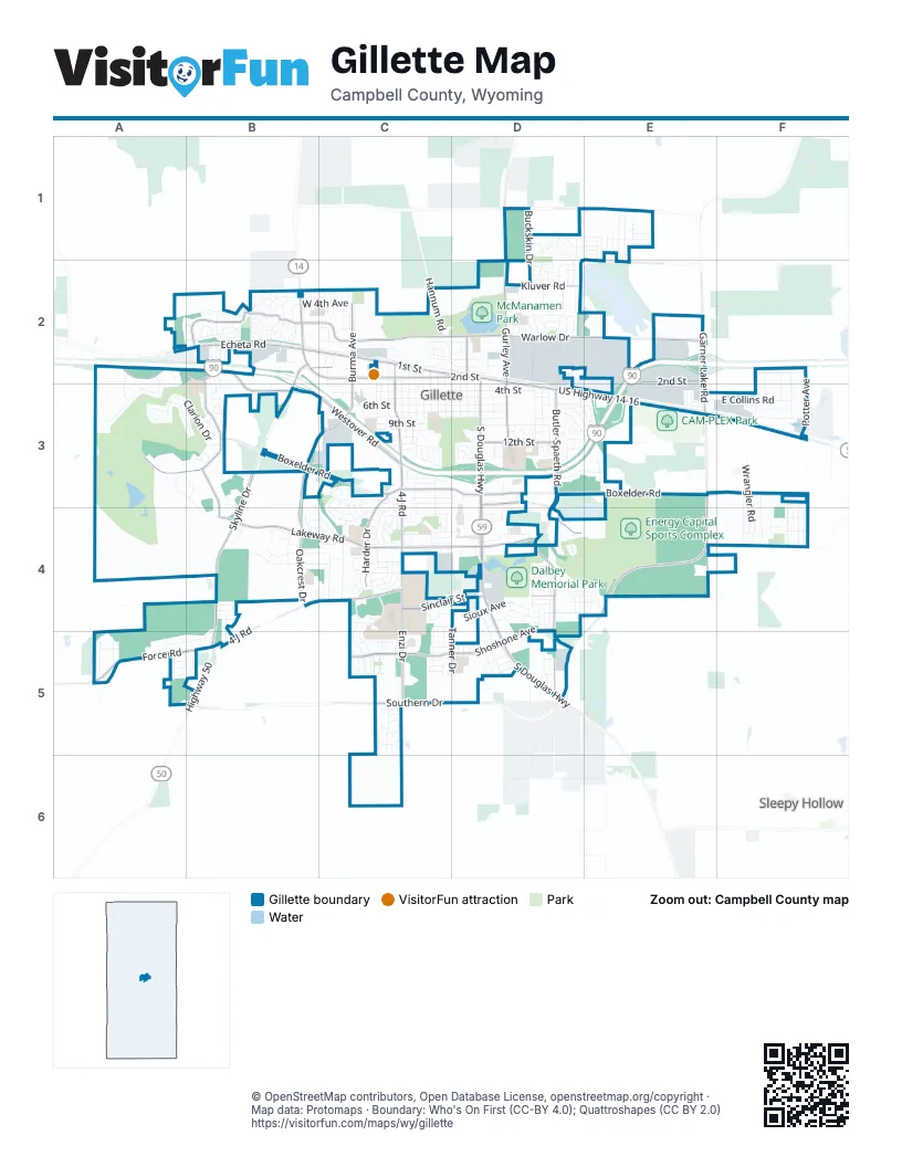
Street index of Gillette
Each street on the sheet and the grid squares it crosses.
- South Douglas HighwayD2, D3, D4, D5
- South Garner Lake RoadE2, E3, E4, D5
- East US Highway 14-16D2, D3, E3, F3
- Skyline DriveB2, B3, B4
- East 2nd StreetC2, D2, E2
- West 2nd StreetB2, C2
- North US Highway 14-16B2
- North Garner Lake RoadE2
- East Southern DriveC5, D5
- West Southern DriveB5, C5
- Highway 50B5
- East Boxelder RoadC3, D3, E3, F3
- Butler-Spaeth RoadD3, D4, D5
- West Lakeway RoadB4, C4
- West Boxelder RoadB3, C3
- South 4-J RoadC3, C4
- West 4-J RoadB4, C4, B5
- Enzi DriveC4, C5
- East Lakeway RoadC4, D4
- 4-J RoadC2, C3
- Northern DriveD1, E1
- Westover RoadA2, B2, B3, C3
- East Warlow DriveC2, D2, E2
- South Burma AvenueC2, B3, C3, B4
- Echeta RoadB2, C2
- Overdale DriveB2, A3, B3
- Kluver RoadD2, E2
- Foothills BoulevardB2
- West Warlow DriveB2, C2
- Sinclair StreetC4, D4
- East Shoshone AvenueD4, C5, D5
- Force RoadA5, B5
- North Gurley AvenueD2
- Harder DriveC3, C4
- West 1st StreetB2, C2
- Shoshone AvenueC5
- Country Club RoadD3, D4
- East 12th StreetD3
- Oakcrest DriveB4
- Moonshiner LaneB3, B4
- North Burma AvenueC2
- South Gurley AvenueD3
- Little Powder River RoadD1, D2
- North Brooks AvenueD2
- West Shoshone AvenueC5
- East 1st StreetC2, D2
- Gurley AvenueD2, D3
- Beaver DriveB3, C3, C4
- Knollwood DriveB4, C4
- East Lincoln StreetD2
- East 6th StreetC3, D3
- Tanner DriveD4, D5
- East 4th StreetC3, D3
- Hidden Valley RoadA5, B5
- East 7th StreetC3, D3
- South Emerson AvenueD2, D3, C4, D4
- Meadow LaneB4, C4
- South Gillette AvenueC2, C3, C4
- East 5th StreetC3, D3
- East Collins RoadE3, F3
- Foothills CircleB2
- Brorby BoulevardC4, C5
- Clarion DriveA3, B3
- West 6th StreetC3
- Buckskin DriveD1, D2
- East 3rd StreetD2, C3, D3
- East 9th StreetD3
- East 8th StreetC3, D3
- Fairway DriveA2, A3, B3
- West 4th StreetC3
- Sierra CircleD3, E3
- Sioux AvenueD4
- West 3rd StreetC3
- Frontage RoadD2, A5, B5
- Arapahoe AvenueD4
- Energy StreetD2
- Rohan AvenueC2, C3
- East Laramie StreetC2, D2
- Potter AvenueF2, F3
- Conestoga DriveE2
- Wigwam BoulevardD4, D5
- Metz DriveC3
- Lakeland Hills DriveD2
- Estes LaneD2
- Ridgecrest DriveC4
- Christinck AvenueC4, C5
- Par DriveA3
- East Railroad StreetC2, D2
- Green AvenueD2, D3
- Longmont StreetC2, D2
- Constitution DriveD1
- Stocktrail AvenueC2, C3
- Town Center DriveD4
- Wrangler RoadF3, F4
- Lexington AvenueC4, C5
- Mountain Shadow DriveA3
- Church AvenueD3
- South Ross AvenueC2, C3
- Goldenrod AvenueB2
- West 4th AvenueB2, C2
- Sako DriveC5
- South Warren AvenueC2, C3
- Wagonhammer LaneC3, C4
- West 8th StreetC3
- Stanley AvenueD3
- Spring Hill RoadA4
- Limecreek AvenueE1
- Primrose DriveD1, D2
- Running W DriveC5
- West 10th StreetC3
- West 9th StreetC3
- University RoadF3
- Richards AvenueC2, C3
- Hi-Line RoadF2
- Hannum RoadC2
- Harvest Moon DriveD4, E4
- Meadow Rose AvenueD1, D2
- Glock AvenueC5
- Pathfinder CircleD2
- Rose Creek DriveC4
- Shalom AvenueD3, E3
- Augusta CircleD4, E4
- Plumcreek AvenueE1
- Granite StreetC3, C4
- Oregon AvenueB2, B3
- Cascade DriveC4
- Watsabaugh DriveC4
- American LaneD1, D2
- Hillcrest DriveB4, C4
- Mills AvenueF2, F3
- South Kendrick AvenueC2, C3
- Carey AvenueC2, C3
- Greenway DriveB2
- Cimarron DriveD3, E3
- Nogales WayB2
- South Osborne AvenueD2, D3
- Badger AvenueF2, F3
- Dogwood AvenueC4
- Larch StreetC2
- West 5th StreetC3
- Sutherland DriveC4
- Almon DriveC4
- Crestline CircleB2
- Enterprise AvenueD2
- Veterans DriveD3
- Beech StreetC2
- South Brooks AvenueD2, D3
- South Miller AvenueD2, D3
- Rockpile BoulevardC2, C3
- Axel's AvenueE3
- Quarter Horse AvenueC4, C5
- Ash Meadows DriveE1
- Chara AvenueE3
- Anvil LaneF3, F4
- Smithie RoadF3, F4
- Westhills LoopB2, B3
- Kristan AvenueF3, F4
- College Park CircleC4
- Cheryl AvenueF3, F4
- East Sinclair StreetD4, E4
- Castle Pines DriveD4
- Commercial DriveC2
- Apricot StreetC2
- Independence DriveD2
- Sammye AvenueF3, F4
- Radio RoadF3
- Summerfield LaneA3, B3, B4
- Stetson DriveD3
- Lodahl AvenueC4
- Saunders BoulevardC4
- Teepee StreetD4, D5
- West 7th StreetC3
- Red Lodge DriveD4
- Bluffs Ridge DriveB3, B4, C4
- Hoback AvenueD4
- Alex WayA5, B5
- Limestone AvenueE2
- Vanscoy DriveC4
- Monte Vista LaneD3, E3
- Frontier DriveC4
- Daybreak DriveF3, F4
- Orchid LaneD2
- Alberta DriveC4
- Elon AvenueD3
- West Juniper LaneC3
- Rocking T DriveC5
- Stafford BendC5
- Fitch DriveC4
- Pintail DriveD4
- West Flying Circle DriveC3
- Tepee StreetD5
- Darrell StreetF4
- Huntington DriveA2, A3
- Vaquero AvenueE2
- Lonigan CircleB2
- West Walnut StreetC4
- Big Lost DriveB4
- East Sunset DriveC2
- Sunridge AvenueA3, B3
- Hunters DriveD4, E4
- Kilkenny CircleB2
- High Cliff AvenueA5
- Ledoux AvenueB4
- Dryfork DriveC3
- Poplar LaneD2
- Eagles Nest CircleD3
- Kiowa AvenueD5
- Edwards StreetD4
- Jayhawker StreetB4, B5
- Collins AvenueF2, F3
- Express DriveC5
- Overland TrailD3
- Wolf Creek LaneD4, E4
- Dakota StreetD5
- Tower AvenueF2, F3
- Mahogany CircleC4
- Milton StreetF3
- Circle DriveD3
- Dalbey AvenueC3
- E-Z StreetD4
- Wilson WayA5
- Prairieview DriveD3
- Saint Andrews LaneD4, E4
- Arizona StreetD1, E1
- Melissa DriveC3
- Cherry LaneD2
- West 12th StreetC3
- Boysen Creek DriveE1
- O'Hara DriveD3
- Sierra DriveD3, E3
- Doud DriveA5
- West 11th StreetC3
- Lakeside DriveC2, D2
- Sunflower LaneD1
- College DriveC4, C5
- Fir AvenueC2
- Trails CircleB3
- Rawhide DriveD2
- Vivian StreetC4
- Chancery LaneA3
- Chippewa AvenueD4
- Almon CircleC4
- Liberty LaneD2
- Aspen LaneD2
- Alison AvenueD5
- Phoenix AvenueD1, D2
- Parkside CircleD4
- Pioneer AvenueB3
- Wilderness DriveC3, C4
- Gabriel DriveD2
- Mountain View DriveB2
- Boise AvenueE1, E2
- Hemlock AvenueB2
- East Limestone AvenueD2, E2
- Quacker AvenueD4
- Kettleson CrossingC5, D5
- Ventura AvenueB2
- Bridger StreetB2
- East Walnut StreetC4, D4
- Cattail DriveD4
- Camel DriveD3
- Derringer DriveC5
- J Cross AvenueC5
- El Camino RoadD3
- Lee-Esther LaneB3
- Utah StreetD1, E1
- Arcadia AvenueD2
- Denver AvenueE1
- Baywood StreetE1
- Kinner DriveC4
- Industrial Park DriveE2, E3
- Helena AvenueE1
- North Gillette AvenueC2
- Exchange AvenueC2
- Bundy AvenueD2
- Mountain Meadow LaneB2
- Sutherland Cove LaneC4
- Federal AvenueD4
- Works AvenueD2
- Mitchell AvenueD4
- North Butler Spaeth RoadD2
- Hunt AvenueC3
- Kirk StreetF4
- Silver Spur AvenueC4, C5
- Saddle String CircleB2
- Mercantile DriveF3
- Cottonwood LaneC3
- West Tonk StreetC3
- Carlisle StreetD4
- Big Sky StreetD4
- Gordon StreetF4
- KG AvenueD4
- Ariel AvenueD4
- Bantam AvenueD4
- Decoy AvenueD4
- Sequoia DriveC4, D4
- East Timothy StreetC4, D4
- Washington StreetB4
- Allen AvenueC4
- Chickasaw AvenueD5
Things to do on the Gillette map
Places on the map
- 1001 Plaza
- 4-J Business Park
- Bell Nob Golf Course
- Bicentennial Park
- Bundy Addition
- Burlington Lake
- Campbell County Health
- Campbell County High School
- Dalbey Memorial Park
- Davis Chevrolet Subdivision
- East Lakeway II Subdivision
- Energy Capital Sports Complex
- Energy Technical Center Tract
- Enzi Practice Fields
- Evangelical Church Subdivision
- Gillette Business Park
- Gillette Fishing Lake
- Gillette Golf Club
- Gillette Gun Club
- Glacier Park Addition
- Highway Addition
- Homestead Addition
- I-90 Addition
- J & L Addition
- Legacy Pointe
- Lincoln Addition
- McManamen Park
- Morrish Property
- Mount Pisgah Cemetery
- Powder Basin Center
- Southside Business Park
- Stocktrail Subdivision
- Sunflower Park
- Thunder Basin High School
- Town Center Subdivision
- Turner Subdivision
- Wagensen Addition
- West Valley Subdivision
- Westside Addition
- Y.E.S. House
Next to Gillette
- Sleepy Hollow
© OpenStreetMap contributors, Open Database License, openstreetmap.org/copyright · Map data: Protomaps · Boundary: Who's On First (CC-BY 4.0); Quattroshapes (CC BY 2.0)















