

Wyoming map
Casper map
About 58,823 people live here (Census Bureau, 2024 estimate). The sheet's index lists 300 streets; CY Avenue, Southeast Wyoming Boulevard and South Walnut Street cross the most grid squares. Also on it: Aaron's, Amoco Park and Banner Wyoming Medical Center.
Open the map (PDF, US Letter)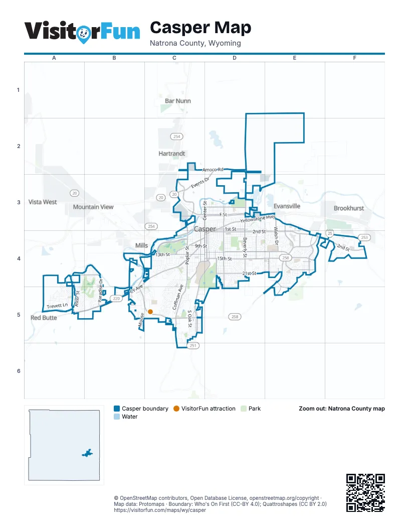
Street index of Casper
Each street on the sheet and the grid squares it crosses.
- CY AvenueB4, C4, A5, B5
- Southwest Wyoming BoulevardB4, B5, C5
- South Poplar StreetC4, C5
- Southeast Wyoming BoulevardE3, E4, C5, E5
- North Poplar StreetC3, C4
- East Yellowstone HighwayD3, E3, D4
- Events DriveD2, C3, D3
- East 1st StreetD3, E3
- East F StreetD3
- East E StreetD3
- West 1st StreetC3, D3, C4
- North Center StreetD3
- West F StreetC3, D3
- North Beverly StreetD3
- State Highway 220A5
- East 2nd StreetD4, E4, F4
- East 15th StreetD4, E4
- Casper Mountain RoadC4, D4, C5
- Amoco RoadC2, D2, D3
- West 13th StreetB4, C4, D4
- South Center StreetD3, D4, C5
- South Beverly StreetD3, D4
- Bryan Stock TrailD2, D3
- West Collins DriveC4, D4
- South Wolcott StreetD3, D4
- South Durbin StreetD3, D4
- South Robertson RoadA4, A5
- North McKinley StreetD3
- Robertson RoadA4, A5
- West 9th StreetC4, D4
- North Hereford LaneD3
- East Midwest AvenueD4
- East 12th StreetD4, E4
- East 21st StreetD4, E4
- King BoulevardC4
- Country Club RoadD4, E4, E5
- South McKinley StreetD3, D4
- South Ash StreetC3, C4, C5
- Newport StreetE4
- East K StreetD3
- Blackmore RoadE4, F4
- Paradise DriveB4, B5
- College DriveC4, D4
- Kingsbury DriveE4
- South Oakcrest AvenueD4
- South Walsh DriveE4
- Riverbend RoadA4, B4
- West English AvenueC3
- Centennial Hills BoulevardE4
- Landmark DriveE4
- North Walsh DriveE3, E4
- Western AvenueE3
- North Mc Kinley StreetD3
- West K StreetC3, D3
- Centennial Hills Boulevard / East 21st StreetE4
- Allendale BoulevardD4
- South Oak StreetC4, C5
- East 18th StreetD4, E4
- South Walnut StreetC3, C4, C5, C6
- South Jefferson StreetD3, D4
- East 8th StreetD4, E4
- Waterford StreetE4
- South Jackson StreetD3, D4
- South Coffman AvenueC4, C5
- South David StreetC3, C4, C5
- East 3rd StreetD4
- South Washington StreetD3, D4
- East 4th StreetD4
- East A StreetD3
- South Elm StreetC3, C4, C5
- East 5th StreetD4, E4
- South Spruce StreetC4, C5, C6
- South Conwell StreetD3, D4
- West 15th StreetC4, D4
- Indian PaintbrushA4, A5, B5
- East 24th StreetD4, E4
- East C StreetD3
- South Melrose StreetD4
- South Nebraska AvenueD3, D4
- Heathrow AvenueE4, E5
- South Lennox AvenueD4, D5
- East 10th StreetD4
- East 14th StreetD4, E4
- Ridgecrest DriveC4, C5
- East 22nd StreetD4, E4
- South Missouri AvenueD4
- South Mitchell StreetD4
- East 6th StreetD4
- South Cedar StreetC4, C5
- South Lincoln StreetD3, D4
- Pheasant DriveC4, C5
- South Fairdale AvenueD4
- Farnum StreetD4
- South Chestnut StreetC4, C5, C6
- Morado DriveF4
- East 17th StreetD4, E4
- Trevett LaneA5
- South Beech StreetD3, D4
- East 19th StreetD4, E4
- Goodstein DriveC5
- West 14th StreetC4, D4
- East 23rd StreetD4, E4
- East 7th StreetD4
- South Forest DriveD4, E4
- Bellaire DriveC4
- South Elk StreetD3, D4
- East 11th StreetD4
- Glendale AvenueD4
- Begonia StreetB4
- West 12th StreetC4, D4
- Aster StreetA5
- Nottingham DriveE4
- Eagle DriveB5, C5
- Cornwall StreetE4
- Trigood DriveE3, D4, E4
- Metro RoadD3, E3
- Arroyo DriveC5
- Honeysuckle StreetB5
- Bonnie Brae StreetD4
- Brookview DriveC5
- East H StreetD3
- ColumbineA5, B5
- Donegal StreetE4
- Valley RoadC5
- South Pennsylvania AvenueD3, D4
- Campus DriveC4, D4
- Valley DriveA5, B5
- Trojan DriveE4
- Navarre RoadC4, C5
- South Wilson StreetD3, D4
- Linda Vista DriveE4
- Carriage LaneE4
- Burlington AvenueD3
- South Fenway StreetD3, D4
- South Boxelder StreetC4
- Kelly DriveE4
- Swanton AvenueD4, E4
- West 29th StreetC4, C5
- Wilkins CircleC3
- Bretton DriveE4
- Belmont RoadC4, C5
- Foster RoadC3
- Sagewood AvenueD4, D5
- East 20th StreetD4, E4
- East Collins DriveD3, D4
- Talon DriveB5, C5
- Saratoga RoadC4, C5
- North Beech StreetD3
- North Kimball StreetD3
- North Durbin StreetD3
- North Wolcott StreetD3
- West 39th AvenueC5
- South Grant StreetD4
- West 11th StreetC4, D4
- North Park StreetD3
- North Grant StreetD3
- West 45th StreetB5, C5
- East 13th StreetD4
- Circle DriveC3
- Whispering Springs RoadA5
- East 16th StreetD4, E4
- South Kenwood StreetD3, D4
- Sunflower StreetA4, B4, A5
- West Midwest AvenueC4, D4
- Lisco DriveC4, D4
- North Glenn RoadC3
- Magnolia StreetB5
- Manor DriveE4
- Meadowlark DriveB5, C5
- North Jackson StreetD3
- Fremont AvenueC4
- West Coffman AvenueC4
- North Lincoln StreetD3
- Village DriveA4, A5
- Shumway AvenueD4, D5
- Knollwood DriveC4, C5
- East L StreetD3
- Mariposa BoulevardC5
- Elkhorn Valley DriveE4
- Indian Scout DriveA5
- East 26th StreetD4
- Payne AvenueD4
- Jonquil StreetB4
- Shattuck AvenueD4
- Rustic DriveD4, E4
- Brentwood DriveC5
- Thelma DriveE3, E4
- South Illinois AvenueD4
- Aster RoadA5
- East M StreetD3
- West Yellowstone HighwayC4
- Stafford StreetE4
- Marigold StreetB5
- South Park StreetD3, D4
- Kearney AvenueC4
- North Washington StreetD3
- Hyview DriveC4
- Lilac StreetB4
- Dahlia StreetB5
- Kit Carson AvenueC4
- West 27th StreetC4, C5, D5
- Yucca CircleA5
- North Jefferson StreetD3
- South Odell AvenueC4, C5
- MooseB5
- Jim Bridger AvenueC4
- South Lowell StreetD3, D4
- Fetterman AvenueC4
- Granite Peak DriveF4
- Painted Horse TrailA4
- Buckboard RoadA5
- Monte Vista DriveC5
- Hanway AvenueC4, C5
- East 25th StreetD4, E4
- Hawthorne AvenueC5
- West 20th StreetC4
- Herrington DriveA5
- West Odell AvenueC5
- Boots DriveE4, E5
- Station RoadE2, E3
- West 25th StreetC4
- Laramie AvenueC4
- Vista WayC5
- Bryan-Evansville RoadD3
- Pinyon ParkwayD4
- Aspen PlaceB5, C5
- Gannett StreetE4
- Miracle DriveE4
- Josendal RoadC4
- Granada AvenueC5
- Placid DriveC5
- Desmet DriveC4
- Calypso StreetB4, B5
- Coronado DriveF4
- Pay It Forward DriveE4
- West 38th StreetB5
- Preserve CircleD4
- FoxB5
- Mountain WayC5
- Wind River AvenueE4
- West 17th StreetC4
- West 60th StreetC5
- East 9th StreetD4
- Kingsboro RoadC5
- Custer AvenueC4
- Prospector DriveB5
- Trappers TrailA5
- West 50th StreetC5
- West 10th StreetC4, D4
- Cody AvenueC4
- Long LaneE4
- Daffodil StreetA5, B5
- Drayton WayE4
- North Lennox StreetD3
- Coulter DriveC4
- Glenarm StreetD3
- Amherst AvenueD4
- North Elma StreetD3
- Washakie StreetE4
- Oleander StreetA5, B5
- Ivy LaneE4
- Cherokee LaneA4, A5
- Coliseum WayF4
- West 19th StreetC4
- Fairview AvenueD4
- Danford CourtE4
- North Elk StreetD3
- South Wisconsin AvenueD4
- Bentley CircleF4
- Cheney LoopE4
- Carmel DriveC5
- Central DriveC5
- Brigham Young AvenueC4
- Coates RoadA5, B5
- West 21st StreetC4
- West 53rd StreetC5
- South Huber DriveD3, D4
- South Magnolia StreetB5
- North Sun DriveD3, E3
- South Willow StreetC4
- Yesness CourtC5
- Bon AvenueD4
- Breck AvenueD4
- Fairgrounds RoadC4
- North Lowell StreetD3
- West 42nd StreetC5
- Ranch RoadF4
- Puma DriveB5
- Luker DriveE4
- South Kimball StreetD3, D4
- Centennial Village DriveE4
- Primrose StreetB4, B5
- North Minnesota AvenueD3
- Clifton AvenueE4
- Falcon Crest BoulevardD5
- Dolomite CircleE4
- North David StreetC3
- North Forest DriveE3, E4
- North Pennsylvania AvenueD3
- Lexington AvenueD4
Places on the map
- Aaron's
- Amoco Park
- Banner Wyoming Medical Center
- Blackmore Marketplace
- Casper College
- Casper Municipal Golf Course
- Casper Speedway
- Centennial Junior High
- Cheney Alumni Field
- Clarion Inn at Platte River
- CY Middle School
- Eastdale Park
- Eastridge Mall
- Field of Dreams Baseball Complex
- Fort Caspar Academy
- Frontier Middle School
- Goodstein Park
- Harry Geldien Stadium
- Highland Cemetery
- Highland Park
- Kelly Walsh High School
- Lavia Linda Trail
- Lincoln Elementary School
- Menards
- Mike Sedar Park
- Mountain Plaza
- Nancy English Park
- Natrona County High School
- North Casper Park
- Paradise Valley Country Club
- Saint Anthony Catholic School
- Summit Medical Center
- The UPS Store
- Three Crowns Golf Club
- Verda James Elementary
- Walmart Supercenter
- Washington Park
- Wyoming Behavioral Institute
- Yesness Park
- Yesness Pond
Next to Casper
- Bar Nunn
- Brookhurst
- Evansville
- Hartrandt
- Mills
- Mountain View
- Red Butte
- Vista West
© OpenStreetMap contributors, Open Database License, openstreetmap.org/copyright · Map data: Protomaps · Boundary: Who's On First (CC-BY 4.0); Quattroshapes (CC BY 2.0)