

Wyoming map
Natrona County map
About 80,410 people live here (Census Bureau, 2024 estimate). The sheet's index lists 300 streets; Thirtythree Mile Road, North Dry Creek Road and West US Highway 20-26 cross the most grid squares. Things to do inside the boundary: Casper and Independence Rock.
Open the map (PDF, US Letter)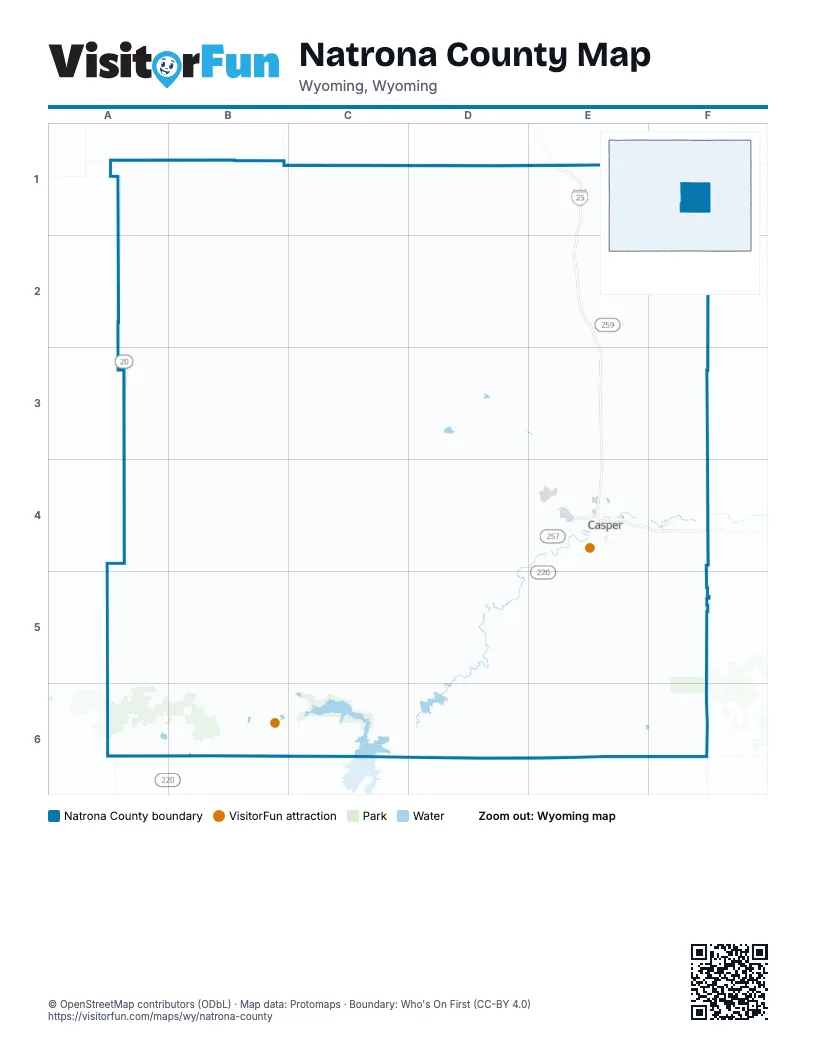
Maps inside Natrona County
1 map inside, from the street map of Natrona County down.
Street index of Natrona County
Each street on the sheet and the grid squares it crosses.
- US Highway 20-26 BypassE4
- West US Highway 20-26A3, B3, C3, D3, D4
- State Highway 220E4, D5, E5
- State Highway 487D5, E5, E6
- East Yellowstone HighwayE4, F4
- CY AvenueE4
- West Belt LoopE4
- West Yellowstone HighwayE4
- Southeast Wyoming BoulevardE4
- Southwest Wyoming BoulevardE4
- South Poplar StreetE4
- North Poplar StreetE4
- Events DriveE4
- East F StreetE4
- East 1st StreetE4
- West 1st StreetE4
- Bryan Stock TrailE4
- East E StreetE4
- Horseshoe RoadE2, E4
- North Center StreetE4
- Curtis StreetE4
- West F StreetE4
- US Highway 87-26-20F4
- North Beverly StreetE4
- Poison Spider RoadA4, B4, C4, D4, E4
- Hat Six RoadF4, F5
- Casper Mountain RoadE4, E5
- North Cole Creek RoadF4
- Salt Creek HighwayE3, E4
- East 2nd StreetE4, F4
- East 15th StreetE4
- Amoco RoadE4
- West 13th StreetE4
- South Robertson RoadE4
- South Center StreetE4
- South Beverly StreetE4
- Yellowstone-Cole Creek RoadF4
- North Robertson RoadE4
- West Collins DriveE4
- Westwinds RoadE4
- South Wolcott StreetE4
- South Durbin StreetE4
- Cole Creek RoadF3, F4
- Howard StreetE4
- North McKinley StreetE4
- Robertson RoadE4
- North Hereford LaneE4
- West 9th StreetE4
- East Midwest AvenueE4
- Cole Creek Road / Hat Six RoadF4
- Thirtythree Mile RoadB1, C1, D1, D2, D3, E3, E4
- Frontage RoadE2, E3
- South Circle DriveE5
- Cottonwood RoadD6
- Pathfinder RoadC5, C6
- Fremont Canyon RoadC6, D6
- Bessemer Bend RoadD4, D5, E5
- Zero RoadD4, E4
- Muddy Mountain RoadE5
- East 12th StreetE4
- West Zero RoadE4
- Six Mile RoadE4
- Garden Creek RoadE4
- East 21st StreetE4
- South McKinley StreetE4
- Goose Egg RoadD5, E5
- Seven Mile RoadE4
- King BoulevardE4
- Country Club RoadE4
- West Ormsby RoadE3
- Blackmore RoadE4, F4
- 6N RoadE4
- Antelope DriveE4
- County Road 705E3
- Sunset BoulevardE4
- East Lathrop RoadE4
- Morgan StreetE4
- South Ash StreetE4
- Newport StreetE4
- Airport ParkwayE4
- East K StreetE4
- Allendale BoulevardE4
- Chamberlain RoadE4
- Pendell BoulevardE4
- Paradise DriveE4
- Kingsbury DriveE4
- College DriveE4
- Alcova AvenueD6
- County Road 202E4
- 1st StreetE4
- West English AvenueE4
- Lewis StreetE1
- Salt Creek ParkwayE4
- South Oakcrest AvenueE4
- South Walsh DriveE4
- McMurry BoulevardE4
- South 4th AvenueE4
- Riverbend RoadE4
- Commerce DriveE4
- Skinner AvenueE4
- Centennial Hills BoulevardE4
- Center StreetE1
- Landmark DriveE4
- Western AvenueE4
- North Walsh DriveE4
- County Road 117E1
- Northwestern AvenueE4
- North 2nd StreetE1
- County Road 119E4
- Van Horn AvenueE4
- North Mc Kinley StreetE4
- South 2nd StreetE1
- West K StreetE4
- Dry Creek RoadD6
- Centennial Hills Boulevard / East 21st StreetE4
- Kortes RoadD6
- North Dry Creek RoadA4, B4, E4, B5, B6, C6
- Buffalo Creek RoadC1, B2, C2
- Oregon Trail RoadD4, E4, C5, D5
- Bates Creek RoadE5, E6, F6
- Oakie TrailA1, B1, A2, B2
- Long Canyon RoadD1, E1, D2
- Baker Cabin RoadB2, C2
- Oil Camp RoadC3, C4, D4
- Bates Hole Stock TrailD5, E5, E6
- Gas Hills RoadB3, A4, B4
- Bolton Creek RoadD5, D6
- Naval RoadE2, F2, F3
- West Willow Creek RoadC1, D1
- East Ormsby RoadE3, F3
- Lost Cabin RoadA2, B2
- Bighorn Mountain RoadB1, B2
- Notches RoadB2, C2, C3
- County Road 211C3, B4, C4
- Spindle Top RoadD5, D6
- Antelope Springs Ranch RoadD1, E1
- Cedar Gap RoadA2
- Lone Bear RoadD1, D2
- Beck RoadC3, D3
- Natrona RoadC3, C4, D4
- Stinking Creek RoadD5, E5
- Bucknum RoadD3, D4
- Canal RoadD5, D6
- Canal Bank RoadD5
- Trapper RoadD5
- Buzzard RoadB6, C6
- Arminto RoadB2, B3
- Forest Oil RoadC4, C5
- Geary Dome RoadF4
- Coal Mountain RoadD5, E5
- Wild Horse RoadD2
- Powder River RoadC3, C4
- Twentymile Hill RoadE2, E3
- Smokey Gap RoadE1
- Sunburst DriveE4, F4
- County Road 506E5
- Lox RoadB3, C3
- Butler Oil RoadA3, A4, B4
- Lakeshore DriveD6
- Oregon TrailB6
- Old Salt Creek HighwayE2, E4
- County Road 607F5
- Bishop RoadD4, E4
- Waltman Sweetwater Freight RoadA4, A5
- Bishop Point RoadC6
- Turkey Track RoadB6
- Ten Mile RoadE4
- Coates RoadE4, E5
- Tye Moore RoadD5
- County Road 315D4, D5
- High LaneD4, D5
- Barron RoadC3
- East Salt Creek RoadE1, F1
- Buelah Belle RoadB6, C6
- Trapper Route RoadD5
- Old Glenrock HighwayE4, F4
- Jim Bridger TrailA2, A3
- County Road 319C5, C6
- Iron Creek RoadD4
- Gray Reef RoadD5, D6
- Twelve Mile RoadD4
- Cottonwood Stock TrailC2, C3
- Lamb RoadF4, F5
- Miles Ranch RoadD5
- Pr RoadE4
- East Henrie RoadwayF4
- Smith Creek RoadF5
- Alcova Hill RoadC6, D6
- Clearfork RoadF4
- South Oak StreetE1, E4
- Micro RoadE5
- Clark RoadD5
- South Jefferson StreetE4
- Scorpion WayF4
- County Road 403E6
- Annis TrailC6
- West Old Yellowstone HighwayE4
- East 18th StreetE4
- Negro Hill RoadF5
- South Walnut StreetE4
- Garbutt RoadD4, E4
- Old Yellowstone HighwayE4
- Harford Airfield RoadE4
- East 8th StreetE4
- Hat Six Access RoadE5
- Flory Sullivan RoadC3
- Wild Horse (113) TrailD2
- Bessemer Bend South RoadD5
- Pedro's PassD3
- Hopi RoadE3, E4
- Platte River RoadF4
- Cardine RoadF5
- Engburg RoadD4, E4
- Johnson Lateral RoadE4
- Waterford StreetE4
- OsageE3, E4
- South Jackson StreetE4
- South Coffman AvenueE4
- California Emigrant RoadA6
- Opal StreetF4
- South David StreetE4
- Chameleon StreetF4
- Speas RoadD4, D5
- East 3rd StreetE4
- MohicanE3, E4
- Lockner RoadE4
- Wolf Creek RoadE4
- Hogadon RoadE5
- South Washington StreetE4
- Palomino AvenueE4
- Alexander RoadF4
- Cottonwood Beach RoadD6
- Rasmus Lee RoadD4, D5
- ArapahoeE3, E4
- Wildcat RoadE4, F4
- East 4th StreetE4
- East Scenic RouteE4
- East A StreetE4
- South Elm StreetE4
- East 5th StreetE4
- Black Beach RoadD6
- South Spruce StreetE4
- South Conwell StreetE4
- Archery Range RoadE5
- Goose Creek CircleF4
- Platte Park RoadE4
- Everett LaneE5
- Bates Creek RouteD5
- Bonnie Brae StreetE4
- West 15th StreetE4
- Silver Leaf RoadE5
- Sandpiper StreetF4
- Cow Camp RoadB4
- Indian PaintbrushE4
- East 24th StreetE4
- East C StreetE4
- Scenic RouteE4
- West 6 WN RoadE4
- West Ross Ridge RoadE4
- Casper CanalD4, D5
- Squaw Creek RoadE4
- South Pou RoadF4
- Twelve RoadD4
- South Melrose StreetE4
- South Nebraska AvenueE4
- Davis WayE4, E5
- Mystery Bridge RoadE4, F4
- Gust RoadA2
- 8 Mile RoadE4
- Homa Hills RoadE3
- Lakeview RoadD6
- Nine Mile RoadE4
- Crimson Dawn RoadE5
- Boles RoadE4
- 6 Mile RoadE4
- Goose Creek RoadF4
- Heathrow AvenueE4
- County Road 212A4
- South Lennox AvenueE4
- Alcova Dam Access RoadD6
- East 10th StreetE4
- Cattle Drive RoadD4
- East 14th StreetE4
- Lone Tree RoadD5
- Ridgecrest DriveE4
- County Road 307D4
- East 22nd StreetE4
- South Missouri AvenueE4
- South Mitchell StreetE4
- Veterans RoadE4
- East 6th StreetE4
- Sharrock RoadE4
- Prairie LaneE4
- South Cedar StreetE4
- North Grass Creek RoadE4
- Bishop LateralE3
- 5th StreetE4
- South Lincoln StreetE4
- Pheasant DriveE4
- South Fairdale AvenueE4
Things to do on the Natrona County map
Places on the map
- Airport Parkway
- Alcova
- Alcova Reservoir
- Antelope Hills
- Bar Nunn
- Bates Creek Reservoir
- Bessemer Bend
- Brookhurst
- Casper
- Casper Country Club
- Casper Mountain
- Casper Municipal Golf Course
- Casper Nordic Center
- Central Wyoming Fairgrounds
- Edgerton
- Edness K. Wilkins State Park
- Evansville
- Gray Reef Reservoir
- Hartrandt
- HAT SIX WILDCAT LAND LLC
- Hogadon Basin Ski Area
- Homa Hills
- Jackson Lake
- John Beaton Reservoir
- Johnson Reservoir Number 1
- Lavia Linda Trail
- Meadow Acres
- Midwest
- Miller Spring Wilderness Study Area
- Mills
- Mountain Plaza
- Mountain View
- North Platte River
- North Platte Riverbank
- Paradise Valley Country Club
- Pathfinder National Wildlife Refuge
- Powder River
- Pratts Soda Lake
- Red Butte
- Reshaw Park
© OpenStreetMap contributors, Open Database License, openstreetmap.org/copyright · Map data: Protomaps · Boundary: Who's On First (CC-BY 4.0); Quattroshapes (CC BY 2.0)