

Wyoming map
Fremont County map
About 39,721 people live here (Census Bureau, 2024 estimate). The sheet's index lists 300 streets; Gas Hills Road, Main Street and Riverview Cutoff cross the most grid squares. Things to do inside the boundary: Wind River Country.
Open the map (PDF, US Letter)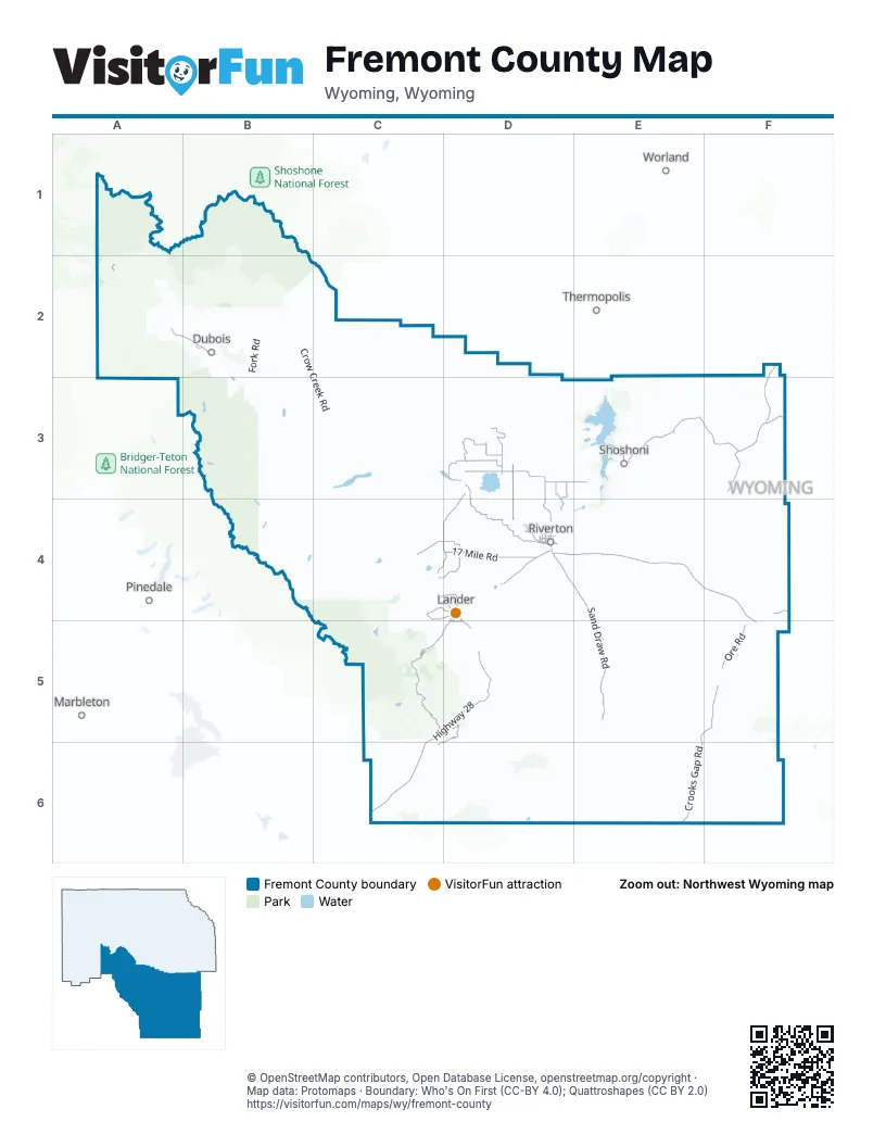
Maps inside Fremont County
1 map inside, from the street map of Fremont County down.
Street index of Fremont County
Each street on the sheet and the grid squares it crosses.
- Gas Hills RoadD4, E4, F4, F5
- Highway 28C5, D5, C6
- Sand Draw RoadD4, E4, E5
- US 26 / US 287A2, B2
- East Main StreetD4, D5
- West Main StreetD4
- Main StreetE3, F3, D4, D5
- West Ramshorn StreetB2
- North Federal BoulevardD4
- Idaho StreetE3
- South 1st StreetB2, D4
- Buena Vista DriveD4
- South Federal BoulevardD4
- South Main StreetD3, D4
- East 2nd StreetE3, D4
- West 2nd StreetE3, D4
- East Ramshorn StreetB2
- Missouri Valley RoadD3, E3
- 17 Mile RoadD4
- Blue Sky HighwayD3, C4, D4
- Rendezvous RoadD4
- Sinks Canyon RoadD4, C5, D5
- Ethete RoadC4, D4
- Airport RoadB2, D4
- Valley View RoadB2, D4
- Fremont StreetB2, F3, D4
- Chandelle BoulevardD4
- South 5th StreetD4
- Badwater RoadE3, F3
- Louis Lake RoadC5
- Ore RoadF4, E5, F5
- Riverview RoadD3, D4
- Crooks Gap RoadE5, E6
- Tunnel Hill RoadD3
- Nowood RoadF2, F3
- Eight Mile RoadD3, D4
- North Pavillion RoadD3
- Plunkett RoadC4, D4
- West Pavillion RoadD3
- Lysite Moneta RoadF3
- Burma RoadD3, D4
- Bonneville RoadA2, E3
- Atlantic City RoadD5, C6, D6
- Two Valley RoadD3, D4
- East Pavillion RoadD3
- Baldwin Creek RoadC4, D4
- West Powerline RoadD3
- Squaw Creek RoadC4, D4
- Davidson RoadD3, D4
- North 2nd StreetD4
- Highway 28 SpurD5
- North 8th Street WestD4
- Mortimore LaneD5
- Kinnear Spur RoadD3
- Williams RoadD3
- Lower North Fork RoadC4, D4
- Major AvenueD4
- East Monroe AvenueD4
- Sand Draw Field RoadE5
- West Sunset DriveD4
- East Webbwood RoadD4
- East Adams AvenueD4
- West Monroe AvenueD4
- North Broadway AvenueD4
- East Pershing AvenueD4
- College View DriveD4
- East Sunset DriveD4
- South 2nd StreetD4
- Hillcrest DriveD4, D5
- South 9th StreetD4
- Webbwood RoadD4
- South Broadway AvenueD4
- West Pershing AvenueD4
- West Adams AvenueD4
- Schoening StreetF3
- Custer StreetD4
- West Center AvenueD3
- Bridger StreetF3, D4
- Monroe AvenueD4
- South Dexter AvenueD5
- East Center AvenueD3
- Wamsutter-Crooks Gap RoadE6
- Riverview CutoffD4, D5, D6, E6
- Maverick Springs RoadC2, C3
- East Fork RoadB2, B3
- Bison Basin RoadE5, E6
- Union Pass RoadA2, A3
- Burris-Lenore RoadB3, C3
- Green Mountain RoadF5, F6
- Castle Garden RoadF3, F4
- Muskrat RoadE3, E4
- Crow Creek RoadB2, C2, B3, C3
- Beaver Creek RoadD4, E4, D5
- Shotgun Butte RoadC2, D2, D3
- Strutting Ground RoadD4, D5
- Moccasin Lake RoadC4
- Arapahoe Ranch RoadD3
- Agate Flat RoadF5, F6
- Buck Camp RoadF3, F4
- Graham RoadE5
- Oil Springs RoadE4
- Wyoming Canal RoadD3
- Wiggins Fork RoadB1, B2
- Bridger Creek RoadF2, F3
- Sheldon Dome RoadC2, C3
- West Shore DriveE3
- Wilderness RoadB3, C3
- Circle Ridge RoadC2
- Twin Creek RoadD5
- Deer Creek RoadF4
- North Fork RoadC4
- Mail Camp RoadC2, C3
- Long Creek RoadA2
- Bass Lake RoadE3
- Paradise Valley RoadD3, D4
- Lysite Creek RoadF3
- Sand Mesa RoadD3, E3
- Washakie Park RoadC4
- Horse Creek RoadB2
- Davison Ranch RoadE3, E4
- Warm Springs Creek RoadA2
- Old Yellowstone HighwayB3, C3
- Gun Barrel RoadF3
- Saint Lawrence Ranger Station RoadC4
- Oregon Buttes RoadC6
- Red Canyon RoadD5
- Fremont County Road 5F4, F5
- Birdseye RoadE2, E3
- Dunoir RoadA2
- West Shoreline DriveE3
- Trail Lake RoadB2, B3
- Point of Mountain RoadE3, F3
- Fort Stambaugh LoopD5
- Brooks Lake RoadA2
- Lewiston RoadD6
- Scotty Clark RoadF3, E4, F4
- North Graham Butte RoadF3
- Sage Creek RoadC4
- Bushwacker RoadD3, E3
- Bear Creek RoadB2
- Hudson-Atlantic City RoadD5
- Riverton Oil Field RoadD4, E4
- South Pass City RoadC5, C6
- West Dinwoody Lake RoadB3
- Gabes RoadD3
- Lyons Valley RoadD4, D5
- Landler Cuttoff RoadC6
- South Fork RoadC4
- Service Canal RoadD3
- Crooks Mountain RoadE6
- Bringolf Ranch RoadD5, E5
- Buckhorn Flats RoadD3, D4
- Poston Ranch RoadE4
- North Portal RoadD3
- Diversion Dam RoadC3
- Warm Springs LoopA2
- Limestone Mountain RoadD5
- Trout Creek RoadC4
- Shoshoni Lake RoadC4, C5
- Quien Sabe RoadE3
- Lost Cabin RoadF3
- North Hidden Valley RoadE3, E4
- Bighorn RoadC3
- Coalmine RoadD4
- North Muddy RoadD3
- Pelham Lake RoadA2
- McCullough RoadD3, D4
- Harris RoadD2, D3
- South Muddy RoadD3
- Lander Mountain RoadC5
- Parque Creek RoadB2
- Left Hand Ditch RoadD4
- Big Eagle RoadE6, F6
- Willow Creek RoadD5
- Burroughs Creek RoadB2
- East Powerline RoadD3
- Dinwoody RoadB3
- Bighorn TrailF3
- Ramshorn Ranch RoadA2
- Little Wind River Bottom RoadD4
- Wildcat RoadA2
- Old Wind River HighwayC4
- North Mountain View DriveB2, D4
- Lost Wells CircleD3, D4
- Johnstown Valley RoadD4
- Clothesline RoadD3, E3, E4
- Water Well RoadF3
- Sheep Creek RoadE6, F6
- Peterson RoadD4
- Harris Bridge RoadD3
- Moneta Shortcut RoadF3
- Goes in Lodge RoadD4
- Canal Service RoadD3, D4
- Angler RoadD3
- Pilot Butte RoadC3, D3
- Indian Ridge RoadD3
- Sheep Camp RoadD3
- South Hidden Valley RoadE3
- Sidewinder RoadD3
- Sand Gulch RoadD3
- Lost Wells Butte DriveD3, D4
- Teacher's RoadD3
- Sand Butte RoadD3
- Pony Creek RoadB2
- Lander Cutoff RoadC6
- Brandau RoadF3
- Pattison Farms RoadD3
- South Ohio AvenueD4
- Urbigkeit RoadC3
- Young RoadD4
- Shetland RoadD3
- Enos Creek RoadA2
- Gravel Pit RoadB2, F3
- Hoot Owl RoadD4, E4
- Mazet RoadD4
- Moccasin Basin RoadA2
- Mill Creek RoadD4
- Ocean Lake RoadD3, D4
- Delfelder RoadD4
- Tweed LaneD4
- Bee RoadD4
- Yellow Calf RoadD4
- River Bluffs RoadC3
- South Fork Fish Creek RoadA2, A3
- Hutchinson RoadD4
- Riverview Cutoff/Continental Divide TrailD6
- Bull Lake RoadC3
- Wilderness DriveB3, C3
- Hall RoadD3, D4
- Fish Lake RoadA2
- Herbst RoadE3
- Ocean View DriveD3
- Soda Springs DriveB2
- Klocke RoadE3, E4
- Fourmile Creek RoadA2
- Little Shield RoadC4, D4
- Stoney Point RoadA2, B2
- Porcupine DriveA2
- Country Acres RoadD4
- Red Creek RoadD6
- North Smith RoadD4
- River Bottom RoadD3
- Givens RoadD4
- Grand Cedars RoadD5
- Winter RoadC5, D5
- Fox Run (Private)B2
- Honor Farm RoadD4
- Riggs RoadE3
- Country Garden LaneD4
- Mission RoadD4
- Long Point RoadD3
- Marlatt RoadD3, E3
- Lower Pelham Creek RoadA2
- Morgan RoadD3
- Shady LaneD3
- Johnstown SpurD4
- Mills RoadD3
- Two Mile RoadD3
- South Irishman RoadD3
- Muddy Creek RoadD3
- Hackamore LaneD3
- North 1st StreetB2, D4
- Gertrude StreetD5
- Fish Hatchery RoadB2
- East 1st StreetE3, D4
- Wilson RoadD4
- Fir RoadA2
- Dirt RoadD3
- Goose Knob DriveD3
- Haymaker RoadD4
- Percheron PathD4
- Ray Lake RoadC4
- Saint Clair SpurC4
- Pickaxe RoadD5, D6
- Iiams RoadD5
- Zig Zag RoadD3
- Alaska RoadD3, D4
- Short Cut RoadF3
- Chugwater RoadC5, D5
- Arkansas Rose RoadD3
- Cooper RoadD4
- Tipperary RoadD3
- Cedar Butte LaneC4
- Sweeney Basin RoadE5
- Trosper RoadD4
- Hancock DriveD4, D5
- Washakie StreetB2, C4, D4
- Missouri RoadD3
- Disneyland RoadD3
- Crow AvenueD4
- V-1 RoadD4, D5
- Mountain View DriveB2
- Lockhart Ranch RoadE6
- Moon Lake RoadA2
- East Park AvenueD4
- Boulder Flats RoadC4
- C Hair LaneD4
- Picket RoadD3
- Gannett Peak RoadB3
- Deadhorse RoadC4
Things to do on the Fremont County map
Places on the map
- Alpine Lake
- Arapahoe
- Atlantic City
- Atlantic City Iron Mine
- Baptiste Lake
- Beaver Creek Nordic Ski Area
- Big Milky Lake
- Bonneville Reservoir
- Boulder Flats
- Boysen Reservoir
- Boysen State Park
- Brooks Lake
- Brown Cliff Lake
- Bull Lake
- Bull Lake Glacier
- Christina Lake
- Continental Glacier
- Copper Mountain Wilderness Study Area
- Crater Lake
- Crowheart
- Deadman Lake
- Dennis Lake
- Dinwoody Glacier
- Dinwoody Lake
- Double Lake
- Downs Glacier
- Downs Lake
- Dubois
- Dubois Badlands Wilderness Study Area
- Ethete
- Fitzpatrick Wilderness
- Florence Lake
- Fort Washakie
- Fortress Lake
- Four Creek Lake
- Frye Lake
- Gannett Glacier
- Gannett Peak
- Gooseneck Glacier
- Popo Agie Wilderness
Next to Fremont County
- Marbleton
- Pinedale
- Thermopolis
- Worland
© OpenStreetMap contributors, Open Database License, openstreetmap.org/copyright · Map data: Protomaps · Boundary: Who's On First (CC-BY 4.0); Quattroshapes (CC BY 2.0)















