

Wyoming map
Riverton map
About 10,953 people live here (Census Bureau, 2024 estimate). The sheet's index lists 291 streets; Davis Lane, West Main Street and North Federal Boulevard cross the most grid squares. Also on it: Riverton Country Club, Aspen Park Elementary and Jaycee Park.
Open the map (PDF, US Letter)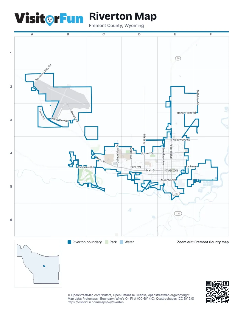
Street index of Riverton
Each street on the sheet and the grid squares it crosses.
- Paradise Valley RoadA2
- Haymaker RoadE2
- Delfelder RoadF2, F3
- Lewis RoadA3
- Valley View RoadA3, B3
- Airport DriveB3
- Airport RoadB3
- Cessna DriveB3
- Chandelle BoulevardB3
- Skylane AvenueB3
- Stinson LaneB3
- Apache AvenueE3, F3
- Clear View DriveE3
- Comanche DriveE3, F3
- Country Acres RoadE3
- Honor Farm RoadE3, F3
- North Federal BoulevardE3, E4, E5
- Shoshone DriveE3, F3
- Sitta DriveE3
- Sunnyside AvenueE3, E4
- Wyoming Penitentiary FarmE3, E4
- Arapahoe DriveF3
- Blackfoot DriveF3
- Cherokee AvenueF3
- Cheyenne AvenueF3
- Crow AvenueF3
- Navaho StreetF3
- North Smith RoadF3, F4, F5
- Sioux AvenueF3
- Welcome RoadF3
- Cathedral CourtB4
- Cathedral DriveB4
- Chimney Rock DriveB4
- Pinehurst CourtB4
- Raintree DriveB4
- Ridgeway RoadB4
- Riverview RoadB4, C4, D5
- Tam-O-Shanter DriveB4, C4, C5
- Temple CourtB4
- Temple Peak DriveB4
- Village DriveB4, B5, C5
- West Mountain View DriveB4
- Windsong DriveB4
- Beth DriveC4
- Broadacres DriveC4, D4
- Brunton CourtC4
- Burton LaneC4
- Campbell LaneC4
- Circle DriveC4
- College View DriveC4
- Connell LaneC4
- Davis LaneC4, D4, C5, D5
- Day DriveC4
- Henry RoadC4
- Hill StreetC4
- Maddux RoadC4
- Mam's WayC4
- Mary DriveC4
- Meadowlark LaneC4
- Morfeld DriveC4
- North Hill StreetC4
- Peck AvenueC4
- Prairie RoadC4, D4
- Rose LaneC4, D4
- Rustler Equine CenterC4
- Short StreetC4
- Watt CourtC4
- West Bend AvenueC4, D4
- West Main StreetC4, D4, D5, E5
- West Park AvenueC4, D4, E4
- West Sunset DriveC4, D4, E4
- Wind River DriveC4
- Wolf Creek DriveC4
- Ash StreetD4
- Big Bend AvenueD4, D5
- Buck Board AvenueD4
- Cactus CircleD4
- Cascade StreetD4
- Dinwoody CircleD4
- Downs CircleD4
- Elizabeth DriveD4
- Elm StreetD4
- Flag DriveD4
- Gasser RoadD4
- Glacier CircleD4
- Hillside StreetD4, D5
- Homestead AvenueD4
- Hunter CircleD4
- Independence DriveD4
- Liberty DriveD4
- Lombardy CircleD4
- Major AvenueD4
- Maple StreetD4
- Mesquite CircleD4
- North 10th Street WestD4, D5
- North 11th Street WestD4, D5
- North 2nd Street WestD4, D5
- North 4th Street WestD4
- North 5th Street WestD4, D5
- North 6th Street WestD4, D5
- North 7th Street WestD4, D5
- North 8th Street WestD4, D5
- North 9th Street WestD4, D5
- Northpointe DriveD4
- PetersdorfD4
- Pioneer AvenueD4
- Sage CircleD4
- Shamrock StreetD4
- Sherry DriveD4
- Sierra DriveD4
- Stoner CircleD4
- Wagon CircleD4
- West Bell AvenueD4, E4
- West Fremont AvenueD4, E4
- West Jackson AvenueD4, E4
- West Lincoln AvenueD4, E4
- West Pershing AvenueD4, E4
- Westwood DriveD4
- Willow RidgeD4
- Antelope DriveE4
- Ashley AvenueE4
- Aspen DriveE4
- Beech DriveE4
- Belinda DriveE4
- Big Horn DriveE4
- Buffalo DriveE4
- Cheryl Sue DriveE4
- Christy DriveE4
- Cindy CircleE4
- Concord AvenueE4
- Debbie StreetE4
- Deer AvenueE4
- Dickinson DriveE4
- Dorrie StreetE4
- East Bell AvenueE4
- East Forest DriveE4
- East Fremont AvenueE4
- East Jackson AvenueE4
- East Lincoln AvenueE4
- East Park AvenueE4, F4
- East Pershing AvenueE4
- East Pine StreetE4
- East Roosevelt AvenueE4
- East Sunset DriveE4
- East Webbwood RoadE4
- Eastview DriveE4
- Edith StreetE4
- Edward AvenueE4
- Eileen StreetE4
- Elk DriveE4
- Energy LaneE4
- Evelyn StreetE4
- Fir StreetE4
- Forest DriveE4
- Hewitt AvenueE4
- Juniper DriveE4
- Lewis StreetE4
- Maple LaneE4
- Mary Anne DriveE4
- Miniweb AvenueE4
- Moose DriveE4
- North 10th Street EastE4, E5
- North 12th Street EastE4, E5
- North 13th Street EastE4, E5
- North 14th Street EastE4
- North 15th Street EastE4
- North 16th Street EastE4
- North 17th Street EastE4
- North 18th Street EastE4
- North 1st StreetE4, E5
- North 2nd Street EastE4, E5
- North 3rd StreetE4
- North 3rd Street EastE4, E5
- North 5th Street EastE4, E5
- North 6th Street EastE4, E5
- North 7th Street EastE4, E5
- North 9th Street EastE4
- North Broadway AvenueE4, E5
- North Forest DriveE4
- Northridge DriveE4
- Northview DriveE4
- Peckham LaneE4, E5
- Philip StreetE4
- Pine StreetE4
- Pinecrest StreetE4
- Porter AvenueE4
- Pure Gas RoadE4
- Railroad AvenueE4, D5
- Rainbow DriveE4
- Redwood DriveE4
- Rose Marie DriveE4
- Southridge DriveE4
- Spencer StreetE4
- Spruce StreetE4
- Sunset PlazaE4
- Timber LaneE4
- Valley CircleE4
- Westridge DriveE4
- Westview DriveE4
- Woodridge DriveE4
- Yvonne DriveE4
- Diamond DriveF4, F5
- Opal DriveF4, F5
- Sapphire AvenueF4
- Stone DriveF4, F5
- Inverness CourtB5
- Prestwich PlaceB5
- Saint Andrew's PlaceB5
- Spy Glass CircleB5, C5
- Torey Pines CourtB5
- Valley Green CircleB5
- Westchester CircleB5
- Westchester CourtB5
- Augusta DriveC5
- Riverside DriveC5
- Arroyo AvenueD5
- Basin AvenueD5
- Butte DriveD5
- Cliff AvenueD5
- East Adams AvenueD5, E5, F5
- Fairview DriveD5
- Falls CourtD5
- Gannet DriveD5
- Hursh StreetD5
- Mesa CourtD5
- Monroe AvenueD5, E5
- Palisades CourtD5
- Peak DriveD5
- Piedmont CircleD5
- Pinnacle DriveD5
- Plateau CourtD5
- Plywood RoadD5
- Rill CourtD5
- South 10th Street WestD5
- South 2nd Street WestD5
- South 3 StreetD5
- South 3rd Street WestD5
- South 4th Street WestD5
- South 5th Street WestD5
- South 6th Street WestD5
- South 7th Street WestD5
- South 8th Street WestD5
- South 9th Street WestD5
- Spire DriveD5
- Summit DriveD5
- Tundra DriveD5
- West Adams AvenueD5
- West Jefferson AvenueD5, E5
- West Madison AvenueD5, E5
- West Monroe AvenueD5, E5
- West Washington AvenueD5
- East Jefferson AvenueE5
- East Madison AvenueE5
- East Main StreetE5
- East Monroe AvenueE5, F5
- East Washington AvenueE5
- Fairgrounds DriveE5
- Heather DriveE5
- Kinnikinnick DriveE5
- Linda Lee RoadE5
- Market AvenueE5
- River LaneE5
- South 10th Street EastE5
- South 11th Street EastE5
- South 12th StreetE5
- South 12th Street EastE5
- South 13th Street EastE5
- South 16th StreetE5
- South 1st StreetE5
- South 20th Street EastE5
- South 2nd Street EastE5
- South 3rd Street EastE5
- South 5th Street EastE5
- South 6th Street EastE5
- South 7th Street EastE5
- South 8th Street EastE5
- South Broadway AvenueE5
- South Federal BoulevardE5
- Tamarisk DriveE5
- Academy CourtF5
- Birch AvenueF5
- Freedom DriveF5
- Garnet AvenueF5
- Jade CircleF5
- Lough StreetF5
- Monroe CourtF5
- Oak LaneF5
- Shortite DriveF5
- South Smith RoadF5
- Sycamore DriveF5
- Walnut DriveF5
Places on the map
- Acme Theatre
- Ashgrove Elementary School
- Aspen Park Elementary
- Atlantic City Federal Credit Union
- Central Wyoming College
- Central Wyoming Regional Airport
- Chopstix Asian Bistro
- Comfort Inn & Suites
- Cornerstone Community Church
- Exxon
- Fremont County Public Library Riverton Branch
- Gem Theatre
- Hampton Inn & Suites Riverton
- Holiday Inn Riverton-Convention Center
- Homestead Living
- Jaycee Park
- Jaycee Park Baseball Field
- Kingdom Hall of Jehovah’s Witnesses
- McDonald's
- Motel 6 Riverton, WY
- Ol' Wyoming Motel
- Paintbrush Inn
- Pit Stop
- Pizza Hut
- Rien Park
- Riverton City Park
- Riverton Country Club
- Riverton High School
- Riverton Middle School
- Riverton Museum
- Riverton Raiders Legion Field
- Riverton Regional Airport
- Riverton Regional Airport Fire Station
- Riverton Town Hall
- Riverton Town Hall and Police Department
- Riverton Volunteer Fire Department
- Rodeway Inn & Suites
- Sunset Park
- Walmart Supercenter
© OpenStreetMap contributors, Open Database License, openstreetmap.org/copyright · Map data: Protomaps · Boundary: Who's On First (CC-BY 4.0); Quattroshapes (CC BY 2.0)















