

Alabama map
Fort Payne map
About 15,017 people live here (Census Bureau, 2024 estimate). The sheet's index lists 300 streets; Greenhill Boulevard Northwest, Gault Avenue South and Gault Avenue North cross the most grid squares. Also on it: Terrapin Hills Country Club, DeKalb Regional Medical Center and Isbell Field.
Open the map (PDF, US Letter)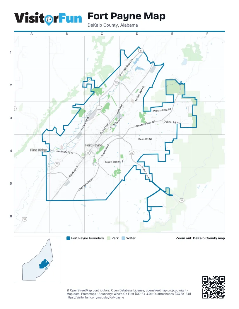
Street index of Fort Payne
Each street on the sheet and the grid squares it crosses.
- Greenhill Boulevard NorthwestD1, C2, D2, C3
- Gault AvenueD2, C3, D3
- Gault Avenue SouthB4, C4, B5, B6
- Glenn Boulevard SouthwestB4
- Wallace AvenueD4, D5
- Wallace Avenue NortheastC4, D4, D5
- Gault Avenue NorthD1, D2, C3, C4
- 5th Street NortheastC4
- 5th StreetC4
- North Valley AvenueB6
- Dogtown Road SoutheastC4, B5, C5, B6
- Adamsburg Road EastC4, C5, D5
- 49th Street NorthwestC2, D2
- Adamsburg RoadC4
- 3rd Street SoutheastC4
- 3rd StreetC4
- Adamsburg AvenueC4
- Desoto Parkway NortheastD3, E3, D4
- Airport Road WestB3, C3, B4
- Scenic Road EastC4, D4
- Desoto ParkwayE2, E3
- Lebanon Road SouthwestA5, B5
- Pine Ridge Road SouthwestA4, B4
- Old Highway 35 EastA4
- Lookout Mountain ParkwayE2
- County Road 51 NorthA5
- Lebanon RoadB5
- County Road 115E2
- Little River Canyon ParkwayE5
- Main RoadE2
- County Road 89E2
- Godfrey AvenueC3, D3, C4
- Grand AvenueC3, B4, C4, B5
- Fruit Farm Road EastC4, D4
- Dean Road NortheastD4, E4
- Houston Loop Road WestB3, C3, B4
- Pumpkin Center Road NortheastD4, E4
- Forest Avenue NorthwestC3, C4
- Fischer Road NortheastD3, E3, E4
- Murdock Road NortheastD3, E3
- Citadell Rock RoadD3
- County Road 255D5, D6
- Alabama Avenue NorthwestC3, C4
- Godfrey Avenue SouthB4, C4, B5
- Briarwood Avenue SouthwestB4, B5
- Martin Avenue NortheastD2, D3
- 67th Street NorthwestD1, D2
- Oakhill Road NortheastE3
- Alabama Avenue NorthC3, D3
- Jennings RoadC5, C6
- Beason Gap Road NortheastC3, C4, D4
- Industrial Lane SouthwestB4, A5, B5
- Williams Avenue NortheastD2, D3, C4
- Chisenhall Road WestB3, B4
- Howell Drive NortheastE3
- Dugout Valley RoadB3, A4, B4
- Hixon Road NorthwestC2, C3
- Williams AvenueC3, D3, C4
- Sylvania Road NorthwestB3, C3
- Kelly Road EastD4, D5
- County Road 78D5, E5
- Big Wills Drive NorthwestD2
- Industrial Boulevard SouthwestB4
- Lincoln Avenue SoutheastC4
- Clark AvenueC3, D3, C4
- County Road 256D6, E6
- Prestwood Drive SouthwestB4
- Gray Road NortheastE2, E3
- Eberhart Road SoutheastC5
- 11th Street NorthwestC3, C4
- McCurdy DriveD4
- Quail Hollow Road NorthwestD1
- Bird Dog Trail NortheastD4, E4
- Driver Road NorthwestD2
- Culpepper Road NortheastD3, D4
- Mitchell Road NortheastE3
- Sanders AvenueC3, C4
- Wooten Gap Road NorthwestC2
- County Road 609B2, C2
- Wade Gap / County Road 604D1, E1
- Sanders Avenue NortheastD3, C4
- Skyline Avenue NortheastC4, D4
- Malibu Road NortheastD4, E4
- Dogwood Circle NorthwestD2
- Kennedy Road NortheastE3, E4
- Stadium DriveD2
- Lincoln AvenueC3, C4
- Boulder DriveC5
- Gann Road SouthwestA5, B5
- Alabama AvenueC4, B5
- Roden Drive NortheastD3
- 48th Street NorthwestC2, D2
- Wilks Drive EastC4
- 35th Street NortheastC3, D3
- Turner AvenueC4
- Portobello Road NorthwestD1
- Chitwood Avenue SoutheastB4, C4
- Hardinger Road NorthwestC2
- Godfrey Avenue SoutheastB4, B5
- Beck Industrial Boulevard NorthwestC3
- Fairway Road NorthwestD2
- 1st StreetC4
- 22nd Street SoutheastB5
- Watkins AvenueC3, C4
- Browder Road NorthwestC2, C3
- Shanna Avenue NortheastD2
- Peachtree Avenue EastC4
- Turner Avenue NortheastC4
- Clark Avenue NortheastC4
- Morrow Road NortheastE3
- 38th Street NortheastD3
- 15th Street NorthwestC3
- 15th StreetC3, B4, C4
- West Horton RoadB3, B4
- Lakewood Drive NorthwestD2
- Forest AvenueC4
- Hester RoadD4
- 9th Street NorthwestC4
- Womack Drive NortheastE2
- New Oregan DriveD3
- 55th Street NortheastD2
- Pack Road NorthwestB3
- Adamsburg Road NortheastC5, D5
- Turner Avenue SoutheastC4
- Crystal Lake DriveC3
- Valhalla Road SoutheastC5
- Oakwood Drive NorthwestD1, D2
- Green AvenueB4, C4
- Lynndale Drive NorthwestC2
- Smith Gap Road NortheastC2
- Sola Circle NortheastD3
- South Old Water Works RoadB4
- 13th Street NorthwestC3, C4
- Grand Avenue NorthC4
- Dunn Road NortheastE3
- 38th StreetC3, D3, B5
- 7th StreetB4, C4
- 8th Street NorthwestC4
- County Road 610C2
- Terminal Drive NorthwestC3
- Cunningham Drive EastC5
- Lookout Terrace EastC4
- Whitehall Cemetery Lane NorthwestD1
- 8th Street SoutheastC4
- Cryer Lane NortheastE3
- Deir Avenue NortheastD5
- Blalock DriveE2
- 8th StreetC4
- Tony Creek Road NortheastD4
- 24th StreetC3, B5
- Lovers LaneD4
- Green Valley Circle NortheastD2
- Tate Road NorthwestC2
- 14th StreetB4, C4
- Anderson Drive NortheastE3
- Evergreen Drive NorthwestD2
- Tyler Avenue SouthC4
- Wills Creek Road NorthwestC3
- Margaret Thacker Lane SouthwestB4
- 18th StreetC3, C4
- Thurmond Loop Road NortheastD3
- Elizabeth Drive NortheastC3
- 4th Street SouthwestC4
- 16th StreetC3, B4, C4
- Gorham Drive NortheastD3
- 10th StreetC4
- 6th Street NortheastC4
- Carrington Avenue SoutheastC5
- Spring Drive NorthwestB3, C3
- 45th Street NortheastD2, D3
- 10th Street NorthwestC4
- 68th Street NorthwestD1, D2
- 19th Street NorthwestC3
- Alabama Avenue SouthwestB4
- Harris Drive NorthwestC3
- Calvin Drive SouthwestB4
- Brookwood Terrace SouthwestB4
- Hawthorne DriveE3
- Hiawatha DriveD1, D2
- Plains Avenue SouthwestB5
- 2nd Street NorthwestC4
- 19th Street NortheastC3, C4
- 35th StreetB5
- Timber Lane NortheastE3, F3
- Evatt Drive SoutheastC5
- Rice Boulevard WestC3
- Owens DriveD4
- Banks Drive NorthwestD2
- Horseshoe Circle SouthwestB5
- Mallard Drive NortheastE3
- 16th Street NorthwestC3
- 4th StreetC4
- Mills Road EastD5
- Westwind Drive NorthwestD1
- 11th StreetC4
- 12th StreetB4, C4
- Mountain Brow Road EastC4
- Mountain Road SoutheastC4
- Field Road NortheastE4
- Jordan Road SouthwestB4
- Lynn Drive NorthwestC3
- Terrace Heights Drive NorthwestD1
- Little Ridge Road NorthwestD2
- Eastview BoulevardC4
- Quail Hollow Drive NorthwestD1
- Caufield Drive NortheastD4
- 3rd Street NortheastC4
- 30th Street NorthwestC3
- Cedarwood Drive SouthwestB4
- Prestwood Avenue NorthwestC3
- Circle Drive NortheastD3
- Hamilton Drive NortheastC3
- 15th Street NortheastC4
- Club Drive NorthwestD2
- Washington Street WestB4
- 4th Street SoutheastC4
- 2nd Street NortheastC4
- 21st Street NorthwestC3
- Mims Street NortheastC3
- Crow Boulevard NorthwestC2
- McCurdy Drive EastD4
- Dewyer Avenue SouthwestB4
- 18th Street SouthwestB4
- Chisenhall Road SouthwestB4
- 8th Street NortheastC4
- 4th Street NorthwestC4
- Grand Avenue SouthwestB4, B5
- Brian Drive NorthwestD2
- Golf Road NorthwestD2
- Tyler Avenue NortheastC4
- Wills Valley DriveD3
- 2nd Street SoutheastC4
- Bear Creek Road SoutheastC5
- 14th Street NortheastC4
- Sequoyah Drive NortheastD2
- Kite Meadow RoadE4
- 41st Street SouthwestB5
- Field Road NorthwestE4
- Green Avenue NorthwestC3, C4
- 13th Street NortheastC4
- Watkins Avenue NortheastC4
- Allen Switch Road NorthwestD2
- Logan Street SoutheastC4
- 35th Street NorthwestC3
- Meadow Drive NortheastE3
- Burk Street NorthwestD1
- 12th Street NorthwestC4
- Monta Vista Drive NorthwestD1
- Grand Avenue SouthB4, C4
- 4th Street NortheastC4
- Isbell Boulevard NorthwestC3
- Laurel Lane SouthwestB4
- 20th StreetC3, B4
- Leath Drive NortheastD3
- Desoto Drive NortheastC3
- Putter LaneD2
- 39th StreetB5
- Dogwood Boulevard NortheastC3, D3, D4
- 34th Street NortheastD3
- Circle DriveD3
- Everett Drive WestC3
- Hollywood Lane EastC4
- 34th StreetB5
- Willowbrook Lane NorthwestC3
- Ruby Lane NortheastD3
- 6th Street SoutheastC4
- 39th Street NortheastD3
- 40th Street NortheastD3
- 45th StreetD2
- Deer Run RoadE3
- Lakeview Road SoutheastC4
- 44th Street NortheastD3
- Clark Avenue SoutheastC4
- Godfrey Avenue NortheastD2, D3, C4
- 5th Street NorthwestC4
- Steele Avenue SouthwestB5
- Allan Lane NorthwestD2
- Manning Drive NorthwestD1
- Stout Road NortheastD4
- 18th Street NorthwestC3
- Rucker Street NortheastC4
- 17th StreetC3, B4
- Copperhead LaneD5
- Buckley DriveD4
- 7th Street NorthwestC4
- Lala Ellen Drive NortheastC3
- 11th Street NortheastC4
- Sanders Avenue SouthC4
- 9th StreetB4, C4
- Louise Avenue NorthwestC3
- 14th Street NorthwestC3, C4
- 2nd Street SouthwestC4
- 63rd Street NorthwestD2
- Daisy Lane SoutheastC5
- Kellett Circle NortheastD3
- 20th Street NortheastC3
- Bear Creek Road NortheastC5
- 6th StreetC4
- Arrowhead Road NorthwestD2
- Cheryl Street NorthwestC2
Places on the map
- Alabama CancerCare
- Alabama Music Park
- All Sorts Liquidation
- Allen Memorial Baptist Church
- Allen Memorial Cemetery
- Bruce's Foodland
- Carter's Beverages
- Castle Rock
- Cecil's Alignment Shop
- Cherokee Plantation
- CITGO
- City Park
- Cricket Wireless
- Days Inn by Wyndham Fort Payne
- DeKalb County Courthouse
- DeKalb County Public Library
- Dekalb County VFW Agricultural Fairgrounds
- DeKalb Regional Medical Center
- Dekalb VFW Agricultural Fairgrounds
- Desoto Country Club and Golf Course
- Desoto State Park Improved Campground
- Desoto State Park Lodge
- Doctors Med Care
- Econo Lodge
- First Presbyterian Church
- Fischer Cemetery
- Fort Payne Boom Town Historic District
- Fort Payne Family Worship Center
- Fort Payne High School
- Fort Payne High School Football
- Fort Payne High School Soccer
- Fort Payne Main Street Historic District
- Fort Payne Memorial Gardens
- Fort Payne Middle School
- Glenwood Cemetery
- Isbell Field
- Terrapin Hills Country Club
- The UPS Store
- Vulcan Materials - Fort Payne Quarry
- Walmart Supercenter
Next to Fort Payne
- Pine Ridge
© OpenStreetMap contributors, Open Database License, openstreetmap.org/copyright · Map data: Protomaps · Boundary: Who's On First (CC-BY 4.0); Quattroshapes (CC BY 2.0)















