

Alabama map
DeKalb County map
About 73,122 people live here (Census Bureau, 2024 estimate). The sheet's index lists 300 streets; State Highway 75, County Road 51 and County Road 47 cross the most grid squares. Things to do inside the boundary: Little River Canyon National Preserve.
Open the map (PDF, US Letter)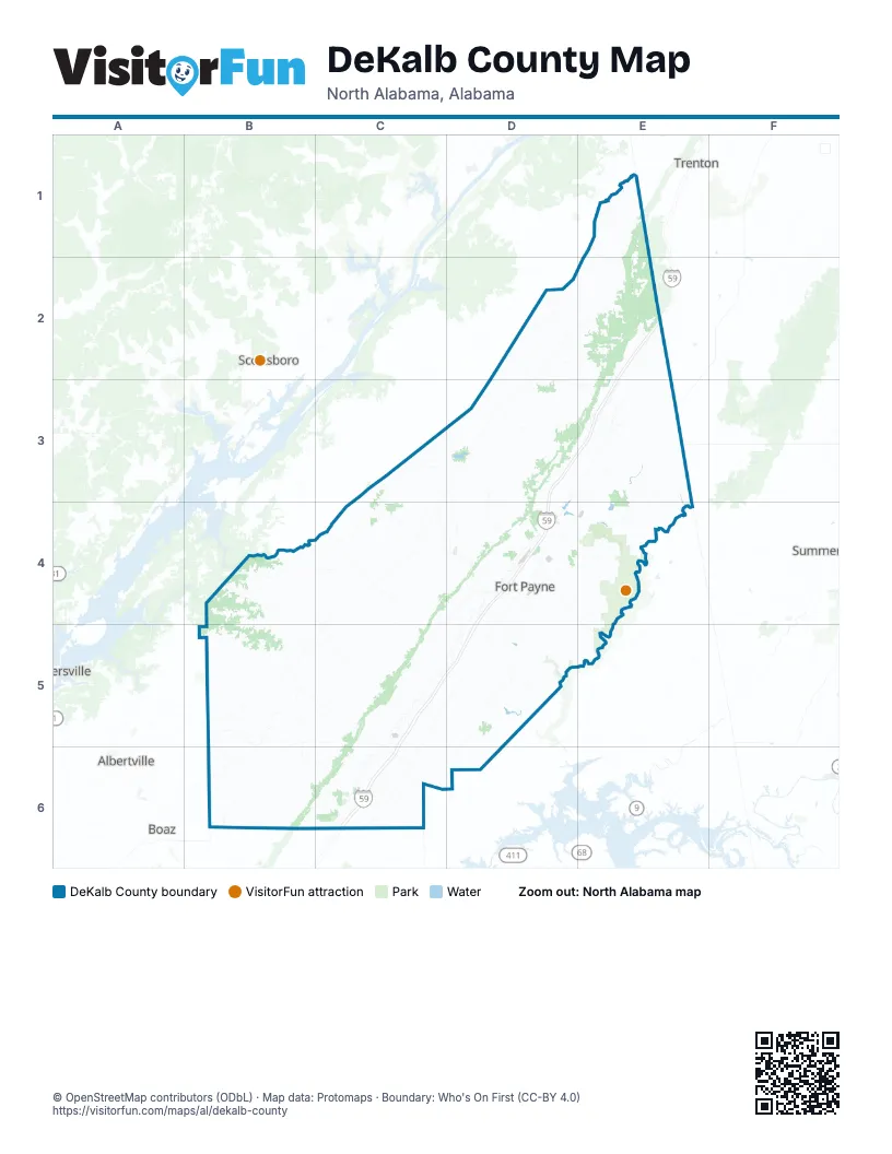
Street index of DeKalb County
Each street on the sheet and the grid squares it crosses.
- North Valley AvenueC5, D5, C6
- Greenhill Boulevard NorthwestD3, D4
- East Main StreetC4, D4, C6
- Gault AvenueD4, E4
- Gault Avenue SouthD4, D5
- Glenn Boulevard SouthwestD4
- Main Street WestC4
- Main Street EastC4, D4
- Wallace AvenueD4, E4
- Wallace Avenue NortheastD4, E4
- West Main StreetC3, C4, C6
- Gault Avenue NorthD4, E4
- Love RoadD4
- South Valley AvenueC6
- 5th Street NortheastD4
- 5th StreetC4, D4
- Tammy Little DriveC3
- State Highway 75E1, D2, E2, C3, D3, C4
- Main StreetC4, B5
- County Road 3B5, C6
- Dogtown Road SoutheastD4, D5
- County Road 137E3, E4
- McCurdy Avenue NorthC4
- Adamsburg Road EastD4, D5
- State Highway 40D3
- McCurdy Avenue SouthC4
- 49th Street NorthwestD4
- Main Street ShilohC4
- Adamsburg RoadD4
- 3rd Street SoutheastD4
- 3rd StreetC4, D4
- DogtownD5
- Tabor RoadC6
- Adamsburg AvenueD4
- Cherokee County 3D6
- Little River Canyon ParkwayD5, E5
- County Road 50B4, C4, C5
- County Road 51C3, D4, C5, C6
- County Road 89E3, E4
- County Road 155E1, E2
- County Road 51 NorthD4, C5, D5
- Blue Pond Boulevard EastD3, D4
- Desoto ParkwayE3, E4
- County Road 47C3, D3, C4, D5
- County Road 88D4, D5
- County Road 24B5
- County Road 106E3, E4
- Wester RoadE3, E4
- County Road 479B6
- Hawkins RoadE2, E3
- County Road 20B4, B5, C5
- County Road 400B4, C4, C5
- County Road 134D2
- Desoto Parkway NortheastD4, E4
- County Road 140E2
- County Road 12B6, C6
- Traylor Street EastC4, C5
- County Road 27C3, D3
- County Road 34B5
- Airport Road WestD4
- Dawson Fairview RoadC5
- County Road 169E1
- County Road 843C5
- County Road 138D2, D3, E3
- Old Highway 35 EastD4
- County Road 115E4, D5
- County Road 180D3, D4
- Marshall Road NortheastC4
- Scenic Road EastD4
- Church Avenue NorthwestC4
- South Broad StreetC4
- County Road 56C4
- North Broad StreetC3, C4
- Traylor Street WestC4
- Lebanon RoadD4, B5, C5
- Lebanon Road SouthwestD4
- West Traylor StreetC4
- County Road 165D2, E4
- County Road 363C6
- Lingerfelt Road NortheastD4
- County Road 835D4
- Lingerfelt RoadD4
- Central RoadD3
- Pine Ridge Road SouthwestD4
- Lookout Mountain ParkwayE4
- Main Street NorthD3, C4
- County Road 634E3, E4
- Main RoadE4
- County Road 59C3
- Bruce RoadB6
- Michaels RoadE1
- County Road 52B5, C5, D5
- County Road 121C3, D3, D4
- County Road 72B4, C4
- County Road 44C4, D4, C5
- County Road 76B4, C4
- County Road 223C5
- County Road 26B6
- County Road 23B5
- County Road 85D3, D4
- County Road 58B5
- County Road 739E2
- County Road 122D3
- County Road 9E3, B5
- County Road 446C4, C5
- County Road 104B5, B6
- County Road 57C5
- County Road 221C5, B6, C6
- County Road 28B5, D5
- County Road 43B4, C4
- County Road 141D2, E2
- County Road 150C5
- County Road 4B6
- County Road 159D2, E2
- County Road 469C6
- County Road 458C4, D4, C5
- County Road 83C5, D5, D6
- County Road 255D5, E5
- Ridgeview DriveD3
- County Road 751D3, E3
- County Road 356B4
- County Road 429C4
- County Road 39C6
- County Road 822C5, D5, C6, D6
- County Road 445C4
- County Road 192B5, C5
- County Road 107D5
- County Road 611E2, E3
- County Road 667D2, D3
- County Road 46B5, C5
- County Road 112D3
- County Road 127D5
- County Road 411B4, B5
- County Road 29B6
- County Road 712D2, E2, D3
- County Road 55D5
- County Road 608D3, E3
- County Road 41C4
- Wills Valley RoadE2, E3
- Citadell Rock RoadD4, E4
- County Road 665D3
- County Road 62C5
- County Road 25B6
- Godfrey AvenueD4
- County Road 30C5
- Greenbriar DriveD3
- County Road 642E3
- County Road 120D3, E3, C4
- County Road 22D5, C6, D6
- County Road 792E1, E2
- County Road 33C4, C5
- Grand AvenueD4, D5, C6
- County Road 631E3
- County Road 685D3, B4
- County Road 114D3
- Lacy RoadD3
- County Road 143D3
- County Road 101D5, D6
- County Road 17B6
- County Road 538B4, C4
- County Road 536B4
- County Road 92C4
- County Road 179B5, B6
- County Road 8B6
- County Road 345B6, C6
- County Road 494D4
- County Road 37C5, B6, C6
- County Road 776D2, E2
- County Road 730E2, E3
- Shady LaneD2, E2, D3
- County Road 630E3
- County Road 788E2
- County Road 569B5
- County Road 651E2
- County Road 329B5
- County Road 90D4
- Fruit Farm Road EastD4
- County Road 108C3, D3, D4
- County Road 119D3
- County Road 116D3
- County Road 512E2
- County Road 671D3
- County Road 732D2
- County Road 386B6
- Kirk Road SouthwestC4
- County Road 6C6
- County Road 79D5
- Everett StreetC4, D4
- County Road 505D4
- Rainbow Avenue NorthwestC4, D4
- County Road 478B6
- County Road 296C5
- County Road 42C5
- Oakhill Road NortheastE4
- County Road 610D3, D4
- County Road 21B6
- County Road 568B5
- County Road 19B4
- County Road 852C5, D5
- County Road 432C4, C5
- County Road 212C5
- VioletE3
- County Road 146E1
- County Road 102C3
- County Road 468B5
- County Road 91C3, D3, C4
- County Road 86C5, C6
- Tumlin RoadC4
- County Road 392B6, C6
- County Road 482B5
- County Road 664D3, E3
- County Road 10B6
- County Road 326C4, C5
- Wade GapD3, D4, E4
- County Road 249D5
- County Road 515C4, D4
- County Road 261E4, D5, E5
- Fischer Road NortheastE4
- County Road 307C5
- County Road 433D3, B5, B6
- County Road 82B5, B6
- Bellview RoadD2, D3
- Rainbow AvenueD3, C4
- County Road 683D3
- County Road 799E1, E2
- County Road 78D5, E5
- County Road 837B6
- Dean Road NortheastD4, E4
- County Road 81E1, D5
- County Road 111B5
- County Road 32D5
- County Road 502C4, D4
- County Road 328B5, C5
- County Road 209C5
- County Road 537B5, B6, C6
- County Road 365B5
- County Road 308C4, D4
- County Road 381B6
- County Road 391B5
- County Road 70B4, B5
- County Road 485D4
- County Road 782E2
- Houston Loop Road WestD4
- County Road 130D5
- County Road 764D2
- County Road 290C5, D5
- County Road 67C3
- County Road 550B4
- Pumpkin Center Road NortheastD4, E4
- County Road 45C5
- Gourge RoadD3
- County Road 572C3
- Union Grove RoadB5, C5, C6
- County Road 15B6
- County Road 571C3, C4
- County Road 821B5
- Forest Avenue NorthwestD4
- County Road 715D2, D3
- Hilltop RoadD3
- Parker Avenue SoutheastC4
- County Road 270D5
- County Road 532C4
- County Road 625E4
- County Road 247C3, D5
- County Road 190C5
- County Road 204C5
- County Road 380B6
- County Road 384B6
- County Road 194D3
- County Road 678D3
- County Road 318C5
- County Road 276C5
- County Road 443C5
- Garrett Street SoutheastC4
- County Road 474E4
- County Road 49C5
- County Road 153E4, E5
- County Road 196C5
- County Road 281D5
- County Road 727D2, E2
- County Road 99D5, D6
- County Road 455B6
- County Road 917C5
- County Road 371D2
- Murdock Road NortheastE4
- County Road 359B5
- County Road 207C5
- County Road 313C5
- County Road 420C4, C5
- Wade Gap / County Road 604E4
- Alabama Avenue NorthwestD4
- County Road 520E3
- County Road 18B5
- County Road 320C4, C5
- County Road 135B5, C5
- County Road 61C4
- County Road 288C6
- County Road 360B5
- County Road 54B5, C5
- Godfrey Avenue SouthD4
Things to do on the DeKalb County map
Places on the map
- Achunachi Lake
- Alabama Welcome Center
- Buck's Pocket State Park
- Camp Comer Scout Reservation
- Cashs Lake
- Castle Rock
- Chitwoods Lake
- Collinsville
- Collinsville Trade Day
- Crossville
- DeKalb County Public Lake
- DeKalb Regional Medical Center
- Fort Payne
- Fyffe
- Geraldine
- Geraldine School
- Geraldine Town Park
- Gilberts Lake
- Gilliam Loop
- Hammondville
- Henagar
- Ider
- Isbell Field
- John Poe Mine
- Lake Lahusage
- Lakeview
- Little River Canyon National Preserve
- Mentone
- Pine Ridge
- Powell
- Rainsville
- Republic Lake
- Sand Valley Landfill
- Sharp Branch Lake
- Shiloh
- Sylvania
- Temples Lake
- Terrapin Hills Country Club
- Valley Head
- Vulcan Materials - Fort Payne Quarry
Next to DeKalb County
- Albertville
- Boaz
- Guntersville
- Scottsboro
- Summerville
- Trenton
© OpenStreetMap contributors, Open Database License, openstreetmap.org/copyright · Map data: Protomaps · Boundary: Who's On First (CC-BY 4.0); Quattroshapes (CC BY 2.0)