

Alabama map
Mobile map
About 201,367 people live here (Census Bureau, 2024 estimate). The sheet's index lists 300 streets; Government Boulevard, Dauphin Street and Airport Boulevard cross the most grid squares. Things to do inside the boundary: Colonial Fort Condé (Fort Charlotte), Gulf Coast Exploreum Science Center and Mobile Carnival Museum.
Open the map (PDF, US Letter)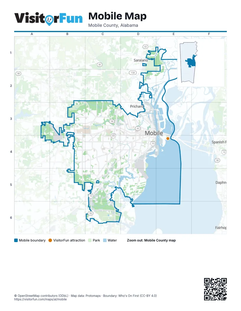
Street index of Mobile
Each street on the sheet and the grid squares it crosses.
- Jubilee ParkwayF2
- George C. Wallace TunnelE2
- Government BoulevardE2, D3, C4, C5, C6
- Dauphin StreetC2, D2, E2, C3, D3
- Moffett RoadB1, C1, C2, D2
- Spring Hill AvenueD2, E2
- Old Spanish TrailE2, F2, F3
- Government StreetE2, D3, E3
- South Broad StreetE2, E3
- West I-65 Service Road NorthD1, D2
- East I-65 Service Road NorthD1, D2
- Saint Stephens RoadD2, E2
- Telegraph RoadE1, E2
- Africatown BridgeE1, E2
- Springhill AvenueC2, D2
- Congress StreetE2
- Canal StreetD3, E3
- Beauregard StreetE2
- South Water StreetE2, E3
- North Water StreetE2
- Broad StreetE3
- North Broad StreetE2
- Saint Anthony StreetE2
- Saint Louis StreetE2
- Africatown BoulevardE1
- Addsco RoadE2, F2
- Claiborne StreetE3
- Bankhead TunnelE2
- Mobile Infirmary BoulevardD2, E2
- South Jackson StreetE2, E3
- Mobile Bay CausewayF3
- Bay Bridge RoadE1, E2
- South Craft HighwayD2, E2
- US 98E2, F2
- New Bay Bridge RoadE1
- Airport BoulevardB2, A3, B3, C3, D3
- Rangeline RoadC5, D5, D6
- Dauphin Island ParkwayD3, D4, E4, D5, E5
- Halls Mill RoadD3, E3, C4, D4, C5
- Zeigler BoulevardB2, C2
- University Boulevard SouthC2, C3, C4
- Michigan AvenueE3, E4
- Hamilton BoulevardC6, D6
- University BoulevardC2, C3
- Demetropolis RoadC4, C5
- Doctor Martin Luther King Junior AvenueD2, E2
- North University BoulevardC1, C2
- Schillinger Road NorthB2, B3
- I- 10 Service RoadE3
- Schillinger Road SouthB3
- Saint Francis StreetE2
- Williams StreetD3
- Victor Birch Memorial BridgeD6
- South Wilson AvenueD2
- Theodore Dawes RoadC6
- Old Shell RoadB2, C2, D2, E2
- Hillcrest RoadB2, B3, B4, B5
- Cottage Hill RoadC3, D3, B4, C4
- Grelot RoadB3, C3
- Azalea RoadC3, C4, D4
- Knollwood DriveC3, C4
- Cody RoadB2, B3
- West I-65 Service Road SouthD2, D3, D4
- Pleasant Valley RoadC3, D3
- Overlook RoadB2, C2
- Duval StreetD3, E3
- Mobile StreetD2
- East I-65 Service Road SouthD2, D3
- Virginia StreetE3
- Conception Street RoadE2
- Howells Ferry RoadC1, B2
- Stanton RoadD2
- Michael BoulevardC3, D3
- Wolf Ridge RoadC1, D1, C2
- South Ann StreetE2, E3
- Shelton Beach RoadC1, C2
- Girby RoadB4, C4
- Airport Boulevard Service RoadC3, D3
- Tanner Williams RoadA2, B2
- Houston StreetE2, D3, E3
- Sollie RoadB4
- Government Boulevard Service RoadD3, C4
- Air Terminal DriveA3
- Bit and Spur RoadC2, C3
- Texas StreetE3
- Summerville StreetD2
- North Lawrence StreetE2
- Ezra Trice BoulevardE3
- South Conception StreetE2, E3
- South Sage AvenueD2, D3
- South Florida StreetD2, D3
- Cody Road NorthB2
- 1st AvenueD1, B2, D2
- State Docks RoadE2
- Chin StreetE1
- South Royal StreetE2, E3
- Paper Mill RoadE1
- Main StreetD1, D2
- Mc Vay Drive NorthD3, D4
- North Catherine StreetE2
- Industrial Canal Road WestE2
- South McGregor AvenueC2, C3
- Old Government StreetD3, E3
- Holcombe AvenueD3
- Industrial Canal RoadE2
- Monroe StreetE2, E3
- North Lafayette StreetE2
- Montlimar BoulevardC3, D3
- Hurtel StreetD3, E3
- Tuthill LaneC2
- Lakeside DriveD3
- McVay Drive NorthD3, D4
- Nevius RoadB4, C4, C5
- Three Notch-Kroner RoadC5
- North Ann StreetE2
- North Sage AvenueD2
- Costarides StreetD2, E2
- McGregor AvenueC3
- Deckle DriveE2
- Bellingrath RoadC6
- North McGregor AvenueC2
- Pleasant AvenueD2, E2
- Springdale BoulevardD2, D3
- North Claiborne StreetE2
- Edwards StreetE1
- Bel Air BoulevardD3
- North Florida StreetD2
- South Claiborne StreetE2, E3
- Hitt RoadB3
- Dawes RoadB3
- Grant StreetD3
- South Catherine StreetE2, E3
- South Lafayette StreetE2, E3
- South State Docks RoadE2
- Cody Road SouthB2
- Noble C. Beasley AvenueD2
- University Hospital DriveD2
- Shelby StreetE1
- Montlimar DriveC3, D3
- Englewood StreetD4
- Woodland AvenueE1
- Delchamps DriveE2
- Old Pascagoula RoadC5
- Page AvenueD2
- Gosson StreetD3
- Tin Top LaneE1
- Kenneth StreetE2
- Rachel DriveB2
- Carol Plantation RoadC6
- Glidden PlaceE2
- Tin Top AlleyE1
- Todd Acres DriveC5, C6
- Navco RoadD3, D4
- Emogene StreetD3
- Bear Fork RoadB1, C1, D1
- Old Military RoadD4, C6
- Bayfront RoadE4, E5
- Church StreetE2, E3
- Riverside DriveD4, E4
- Club House RoadD4, E4, D5
- Service RoadC5
- Conti StreetE2, D3, E3
- Old Bay Front DriveE4
- Gill RoadD4, E4
- South Washington AvenueE2, E3
- Wellington StreetD1, D2
- Higgins RoadC5, D5
- Demetropolis Service RoadC4
- Marine StreetE2, E3
- Donald StreetD2, E2
- Riviere du Chien RoadC4, D4
- West Commerce BoulevardC5
- Venetia RoadD4
- Zeigler Boulevard Service RoadB2, C2
- Lloyds LaneB4
- Highway 90 DriveD3, C4
- Perimeter RoadE3, D4
- Elmira StreetE3
- Museum DriveC2
- Palmetto StreetE3
- Center StreetE1, B2, E2
- Glenwood StreetD3
- Baker StreetE3
- Riverforest DriveD5
- Alba Club RoadD4, D5
- Perimeter DriveE4
- Airbus WayE4
- Ralston RoadD3
- State StreetE2
- Staples RoadD5, E5
- Mohawk StreetD2, D3
- Adams StreetE2
- New Jersey StreetE3
- Satchel Paige DriveD3
- Boykin BoulevardD5, E5
- Westwood StreetD2, D3
- Pinehill DriveD3
- Mac Bayou DriveD6
- South Warren StreetE2, E3
- Gayle StreetE3
- Rangeline Service RoadC5, D6
- Flave Pierce RoadA2, A3
- Selma StreetE3
- South Lawrence StreetE2, E3
- 6th StreetB2, E3
- Longleaf DriveC4
- West Riviere du Chien RoadD4, D5
- Dickens Ferry RoadB2
- Osage StreetD2, E2
- Hunter AvenueD3, E3
- Hannon RoadE5
- Todd BoulevardC5
- John Counts DriveB2
- Stewart RoadE4, E5
- Crenshaw StreetD2, D3
- Viaduct RoadE1
- Kooiman RoadC5
- Scenic DriveD5
- Aubrey Green DriveB2, C2
- Bay AvenueE3
- South Scott StreetE2, E3
- Somerby DriveB3
- South Dearborn StreetE2, E3
- Gaillard DriveC2
- Jessie StreetD1, D2
- Park AvenueB2, D2, D3, D4
- Eagle DriveD3, E3
- Lees LaneD4
- Japonica LaneC3
- Saint Emanuel StreetE2, E3
- Stein StreetC2, D2
- Burma RoadC4
- Cherokee StreetD3, E3
- Foreman RoadB2, B3
- Providence Park DriveB3
- Antwerp StreetE3
- Middle Ring RoadB2
- Pace ParkwayC3, C4
- Ghent StreetE3
- Basil StreetE2
- East RoadC3, C4, C5
- Pecan StreetE2
- Shipyard RoadC4, C5
- Park RoadE5
- Augusta StreetE3
- Gulfdale DriveE4
- Charleston StreetE3
- Saint Michael StreetE2
- Baltimore StreetE3
- South Cedar StreetE2, E3
- Forest Hill DriveC2
- Fairway DriveD3
- Commanders DriveE3, E4
- Mill StreetD2
- Josephine StreetD2
- West Cardinal DriveD3, E3
- North Jackson StreetE2
- Willis RoadC5
- McRae AvenueD3
- Raines DriveC3
- Old Government Street RoadB3
- Downtowner BoulevardC3
- Farnell DriveD4
- Colonial Oaks DriveC1, C2
- Rosedale RoadD4, E4
- Cedar Crescent DriveE4
- South StreetD2, D3
- Rochester RoadC3
- Terrell RoadD5, E5
- Butler StreetD1, D2
- Wesley AvenueC3
- Usa North DriveB2, C2
- Schaub AvenueB3
- Carlisle Drive EastC1, C2
- Farnell LaneD3
- Rutgers RoadC5
- Western DriveD2
- Berkley AvenueD1
- Savannah StreetE3
- South Bayou StreetE2, E3
- Louise AvenueB3
- Yeend StreetE3
- Darwood DriveD4
- Saint Madar StreetE2
- 8th StreetB2, E3
- Cypress Shores DriveC5
- Athey RoadB2
- Kentucky StreetE3
- Eslava StreetE2, E3
- Avenue CB2, E3
- Jaguar BoulevardB2, C2
- Panorama BoulevardC3
- 9th StreetB2, E3, E4
- McNeil AvenueB3, C3
- Morgan AvenueD3
- Roosevelt AvenueB2, D2
- Cotton StreetD2
- Woodland RoadC4
- Magnolia RoadD3
- South Monterey StreetE2, E3
Things to do on the Mobile map
Places on the map
- Africatown Historic District
- Alabama Army National Guard
- APM Intermodal Terminal
- Azalea City Golf Course
- Battleship USS Alabama
- BayPointe Hospital
- Bel Air Mall
- Brookley by the Bay
- Campground Historic District
- Church Street East Historic District
- Cypress Creek Golf Course
- Downtown
- Glenn Sebastian Nature Trails
- Heron Lakes Country Club
- Hog Bayou
- Langan Park
- Leinkauf Historic District
- Magnolia Grove Golf Course
- Maysville Historic District
- McDuffie Island
- McGowin Park
- Medal of Honor Park
- Meggison Park
- Midtown Historic District
- Mobile City Council District 1
- Mobile City Council District 2
- Mobile City Council District 3
- Mobile City Council District 4
- Mobile City Council District 5
- Mobile City Council District 7
- Mobile Infirmary
- Oakdale Historic District
- Pinto Pass
- Spring Hill Lake
- The Country Club of Mobile
- Tom Roush Tract
- Twelvemile Island
- USA Mountain Bike Trails
- USS Alabama Battleship Memorial Park
- W. L. Holland Wildlife Management Area
Next to Mobile
- Prichard
© OpenStreetMap contributors, Open Database License, openstreetmap.org/copyright · Map data: Protomaps · Boundary: Who's On First (CC-BY 4.0); Quattroshapes (CC BY 2.0)