

Alabama map
Montgomery map
About 195,818 people live here (Census Bureau, 2024 estimate). The sheet's index lists 300 streets; Vaughn Road, Northern Boulevard and Eastern Boulevard Service Road cross the most grid squares. Things to do inside the boundary: Alabama Department of Archives and History, Alabama State Capitol and Civil Rights Memorial.
Open the map (PDF, US Letter)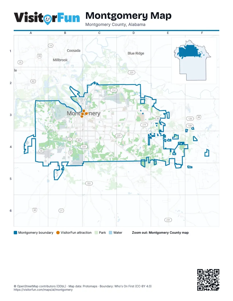
Street index of Montgomery
Each street on the sheet and the grid squares it crosses.
- Northern BoulevardC2, D2, B3, C3
- Selma HighwayA4, B4
- Atlanta HighwayC3, D3, E3
- Taylor RoadD3, D4
- Eastern BoulevardD3, C4, D4
- Troy HighwayC4, D4, D5
- Birmingham HighwayA3, B3
- Eastern Boulevard Service RoadD2, D3, C4, D4
- East South BoulevardC4
- Norman Bridge RoadC3, C4
- South Court StreetC3, C4
- South BoulevardB4, C4
- West BoulevardB3, B4
- Mobile HighwayB3, B4, B5
- East Boulevard Service RoadD3, D4
- Day StreetB3
- Wetumpka HighwayD2
- Chantilly ParkwayE3
- Hackel DriveD3
- Vaughn RoadC3, D3, F3, D4, E4, F4
- Woodley RoadC3, C4, D4
- Wares Ferry RoadD2, C3, D3
- Congressman W. L. Dickinson DriveC2, D2
- Federal DriveC2, C3
- Coliseum BoulevardC2, C3
- Carter Hill RoadC3, C4
- Lower Wetumpka RoadC2, C3
- Maxwell BoulevardB3
- South Perry StreetC3, C4
- Perry Hill RoadC3
- Highland AvenueC3
- Madison AvenueC3
- McLemore DriveD2, D3
- Upper Wetumpka RoadC3
- North Court StreetC2, C3
- West Fairview AvenueB3, C3
- North Decatur StreetC3
- Ann StreetC3
- East Fairview AvenueC3
- North Ripley StreetC3
- McGehee RoadC4
- Bell StreetB3
- Technacenter DriveE3
- South Decatur StreetC3
- Alabama River ParkwayC2
- 6th StreetC2, B3, C3, B4
- Zelda RoadC3
- Clay StreetB3
- Jackson Ferry RoadC2, C3
- Herron StreetB3
- South Union StreetC3
- Mc Gehee RoadC4
- East Jefferson StreetC3
- High StreetC3
- Fisk RoadC4
- North Perry StreetC3
- Columbus StreetC3
- Dickerson StreetB3
- Arba StreetC3
- East South StreetC3
- Bibb StreetB3, C3
- North Union StreetC3
- Tallapoosa StreetB3, C3
- North Holt StreetB3
- Lee StreetC3
- Crestview StreetC3
- West Jefferson StreetC3
- South StreetC3
- Bell RoadD3, D4
- Narrow Lane RoadC3, C4
- Hyundai BoulevardB5, C5
- Old Selma RoadA3, B3, A4
- Old Pike RoadE4, E5
- Oak StreetB3, B4
- Ray Thorington RoadD4, E4
- Rosa L Parks AvenueB3, B4
- Hayneville RoadB3, B4
- Eastchase ParkwayD3, E3
- North Burbank DriveD3
- Carmichael RoadC3, D3
- Well RoadB3, A4
- Air Base BoulevardB3
- Fieldcrest DriveC3, C4
- Virginia Loop RoadC4
- Halcyon BoulevardD3, D4
- West Edgemont AvenueB3, C3, B4
- McInnis RoadC4
- Hill StreetB3
- Fairground RoadC2, C3
- South Holt StreetB3
- Dalraida RoadC3
- Early StreetB3, C3
- Ryan RoadE3, E4
- South McDonough StreetC3
- South Lawrence StreetC3
- Harrison RoadC3
- Adams AvenueC3
- Mobile RoadB3
- Parallel StreetB2, B3
- Poplar StreetB3, C3
- East Edgemont AvenueC3
- Chestnut StreetB3, C3
- Buckingham DriveC4
- East Patton AvenueC4
- Meriwether RoadD3, E5
- Gibson StreetC2
- Clayton StreetB3, C3
- Wasden RoadB5
- Berryhill RoadD3
- Mount Meigs RoadC3
- Dexter AvenueC3
- Forest AvenueC3
- Monroe StreetC3
- Mulberry StreetC3
- West Patton AvenueB4, C4
- Washington AvenueC3
- Mildred StreetB3, C3
- North Mc Donough StreetC3
- East Vandiver BoulevardC2
- South Burbank DriveD3
- South Capitol ParkwayC3
- South Bainbridge StreetC3
- Holcombe StreetB3
- Adrian LaneC4
- North Lawrence StreetC3
- North Bainbridge StreetC3
- South Ripley StreetC3
- Mobile StreetB3
- Glen Grattan DriveC3
- Catoma StreetB3, C3
- Capitol ParkwayC3
- Coosa StreetB3, C3
- North Capitol ParkwayC3
- Putnam StreetC3
- Church StreetB3, C3
- North Goldthwaite StreetB3
- Twain CurveD3
- Aster DriveD3
- West 2nd StreetC3
- Goldthwaite StreetB3
- West South StreetB3, C3
- Glen Grattan AvenueC3
- South Boulevard Service RoadB4, C4
- Greenwood CemeteryC3
- March StreetB3
- Park CrossingD4, E4
- Hunter Loop RoadA3, B3
- Washington Ferry RoadA3, B3
- Deer Creek BoulevardE4
- Wynlakes BoulevardE3, E4
- Fernway DriveC3, C4
- Festival DriveD3, D4
- Edgar D Nixon AvenueB3, B4
- Thomas AvenueC3, C4
- River RoadB3
- AUM DriveD3
- South Hull StreetC3
- Woodmere BoulevardD3
- Roquemore StreetA3, B3
- Cloverdale RoadC3, C4
- Dunbarton RoadD3
- Lamar RoadB4
- Old Hayneville RoadA4
- Audubon RoadC3, C4
- Gunter Park Drive WestC2, D2, C3, D3
- County Downs RoadC3, D3
- Gaston AvenueB3, B4
- Foshee RoadB3
- Brewbaker DriveD4
- Fuller RoadD2
- Richardson RoadA4, B4
- Southmont DriveC3, C4
- Concrete DriveC2, C3
- Todd RoadD2
- Pelzer AvenueC3
- Red Tail DriveA4
- Le Bron RoadC3, C4
- Vaughn Lakes BoulevardD3, D4
- Forbes DriveC2
- Pinebrook DriveD3
- Gilmer AvenueC3, C4
- Kathmoor DriveD3
- Young Meadows RoadD4
- Fairlane DriveD3, C4, D4
- Arrowhead DriveE3
- Willow Lane DriveC3
- Baldwin Brook DriveC4
- Folmar ParkwayB5
- Halcyon Summit DriveD3
- Lakeridge DriveD3, E3, E4
- Hall StreetC3
- Spring Valley RoadC4
- Harmony StreetB3, B4
- Felder AvenueC3
- Biltmore AvenueC3
- West Fleming RoadB4, C4
- Ray DriveC3, D3
- Seminole DriveD3, E3
- Halcyon DriveD3
- Central ParkwayD3
- Monticello DriveD3
- Wentworth DriveC3
- Payne RoadD4
- Karen RoadC3
- Tower RoadA4
- Lynwood DriveC4
- Strathmore DriveC4
- Wilmington RoadC3, C4
- Bienville RoadC3, D3
- Taylor Oaks CircleD4
- Carol Villa DriveD3
- West Fred D. Gray AvenueB3, C3
- Edinburgh DriveD4
- Remington RoadD4
- Woodmere LoopD3
- Lansdowne DriveC3, C4
- Green Ridge RoadC3
- Gunter Park Drive EastD2, D3
- Eastdale CircleD3
- Sunshine DriveC4
- Old Marsh WayD3, D4
- Lagoon Business LoopD2, D3
- Ashley RoadB3
- Eastchase LaneD3, E3
- Malabar RoadC4
- Watson CircleD3
- Mossy Oak DriveE3, E4
- Woodley CircleD4
- North McDonough StreetC3
- Bellehurst DriveC3
- Seibles RoadC4
- Copperfield DriveD3, E3
- Willow Springs DriveB4, A5
- Beardsley DriveC3, D3
- Bankhead AvenueC3, C4
- Southlawn DriveB4
- Selfridge StreetB3
- Sanders LaneD2
- Hillman StreetC3
- Mill StreetB3
- Chisholm StreetC2
- Marlowe DriveC4
- Lockwood LaneC4
- University Drive NorthC3
- Vaughn LaneC3
- Queensbury DriveC4
- Plantation WayD3
- Dalraida ParkwayC3
- Wallahatchie RoadE4, E5
- Young Farm PlaceD3, D4
- Princeton RoadC4
- Grove StreetC3
- Augusta AvenueC4
- Marston WayE4
- Oakbrook DriveC2
- Patrick RoadB3
- Johnstown DriveC3, D3
- Macedonia DriveD4
- East DriveB3, D3
- Thomason AvenueB3
- Avondale RoadC3
- Brewer RoadA4, B4
- Lakewood DriveB3, C3
- Chennault CircleB3
- Promenade BoulevardD3
- Minnie Brown RoadE3
- Green Leaf DriveB4
- Mulzer BoulevardB3
- Autumnbrooke WayE4
- Stoneybrooke WayE3
- Winona AvenueC3
- North Colonial DriveC4
- St Charles AvenueC3
- Plymouth StreetC3
- Autumn Ridge RoadD3, E3
- National StreetB4, C4
- Chappelle LaneD4
- Windsor AvenueC3
- Ryan Ridge LoopE3
- Emory Folmar BoulevardC2
- Chadburn CrossingD4
- Rosedon DriveC4
- Oldfield DriveD3, E3
- Yancey AvenueC3
- Rigby StreetC2
- Parkview Drive SouthD3
- Felder RoadA4
- Yarbrough StreetC2
- Ryan StreetC3
- Terminal RoadB3
- Medal of Honor Memorial DriveC3
- Ellis DriveB3, B4
- Cedar StreetC2, B3, C3
- Lancaster LaneC3
- Myrtlewood DriveC3
- Cherry Hill RoadD4
- Plum StreetC3
- Sayre StreetC3
- Kingsbury DriveC3, C4
- Lagoon Park DriveD3
Things to do on the Montgomery map
Places on the map
- 187th Fighter Wing
- Alabama Agricultural Center
- Alabama National Guard
- Alabama State University
- Arrowhead Country Club
- Baptist Medical Center East
- Baptist Medical Center South
- Blount Cultural Park
- Buddy Watson Park
- Centennial Hill Historic District
- Chisholm Park
- City of St. Jude
- Cottage Hill Historic District
- Crump Park
- Cypress Tree Golf Club
- Eastdale Mall
- Encompass Health Rehabilitation Hospital Of Montgomery
- Froggy Bottom Pond
- Gateway Golf & Learning Center
- Gateway Park
- Goodwyn Park
- Greenwood Cemetery
- James W. Wilson Jr YMCA
- Lagoon Park
- Lagoon Park Golf Course
- Maxwell Air Force Base
- Maxwell Air Force Base - Gunter Annex
- Montgomery Academy
- Montgomery Country Club
- Montgomery Regional Airport (Dannelly Field)
- Montgomery Whitewater
- Montgomery Youth Facility
- Montgomery Zoo
- North Ramp
- Park Crossing
- Park Crossing High School
- Peacock Tract Historic District
- Saint James School
- The Shoppes at Eastchase
- Wynlakes Golf and Country Club
Next to Montgomery
- Blue Ridge
- Coosada
- Millbrook
© OpenStreetMap contributors, Open Database License, openstreetmap.org/copyright · Map data: Protomaps · Boundary: Who's On First (CC-BY 4.0); Quattroshapes (CC BY 2.0)