

Alabama map
Talladega County map
About 81,375 people live here (Census Bureau, 2024 estimate). The sheet's index lists 300 streets; Stemley Bridge Road, Valley Road and Springhill Road cross the most grid squares. Things to do inside the boundary: International Motorsports Hall of Fame, Majestic Caverns and Talladega Superspeedway.
Open the map (PDF, US Letter)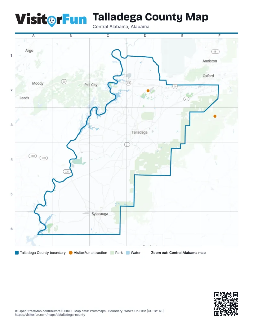
Street index of Talladega County
Each street on the sheet and the grid squares it crosses.
- Western BypassD3
- Stemley Bridge RoadC2, D2, C3, D3
- Broadway AvenueD3, C5, C6
- Bullocks Ferry RoadC4
- Providence RoadD2, D3
- Priebes Mill RoadE2
- Forest Glen RoadB5, C5
- Rockford HighwayC6
- New Lincoln RoadD3
- West Fort Williams StreetC6
- Jones LaneD2, C3, B5
- County Road 414D2
- Old Lincoln HighwayD2
- Idelia RoadD3
- Gantts Junction RoadB5, B6
- Orangevale RoadC4
- North Broadway AvenueC6
- South Broadway AvenueC6
- Pine School RoadC4
- County Road 364D2
- Conchardee LaneD2
- Odyssey LaneD3
- Donald G. Holmes BypassE2
- Piney LaneC4
- Plant RoadC3, B4, C4
- Ashland HighwayD3, D4
- Stemley RoadC2, C3
- Desoto Caverns ParkwayB4, C4, B5
- Eastaboga RoadD2, D3
- Renfroe RoadB3, C3, B4
- Speedway BoulevardD2
- Goodwater HighwayC6
- McIntosh RoadE2, F2
- Mudd StreetD1, D2
- North Street EastD3
- Old Birmingham HighwayB5, C5, C6
- Millerville HighwayC6
- Fort Lashley AvenueD3
- West Battle StreetD3
- East Renfroe RoadC3, D3
- John N Wills AvenueD2
- Coosa Pines RoadB4, B5
- East Battle StreetD3
- West Mc Millan StreetD3
- 3rd StreetC6
- Court Street NorthD3
- Haynes StreetD3
- North East StreetD3
- Chandler CircleD4
- County Road 7D2, D4
- 1st Street SouthwestB5
- 1st Street SoutheastB5
- South East StreetD3
- North StreetF2, D3
- Highway 77D4
- West McMillian StreetD3
- Jackson Trace RoadD1, D2, D3
- Childersburg Fayetteville HighwayB5, B6
- Berneys Station RoadD3, C4, D4
- Old Sylacauga HighwayB5, C5
- Sylacauga-Fayetteville HighwayB6, C6
- Glovers Ferry RoadB3, C3, B4
- Howells Cove RoadC2, D2, C3
- Curry Station RoadD2, E2, D3
- Valley RoadE2, D3, C5, D5
- Kings Chapel RoadB4, C4
- West Renfroe RoadC3
- Stockdale RoadD3, D4
- Plantersville RoadC3, C4
- Oakdale RoadC4, C5
- Oldfield RoadC5
- Allison Mill RoadD3, D4
- Shocco Springs RoadC3, D3
- Richeytown RoadD2, E2
- Cove Acess RoadC2, C3, D3
- Coaling RoadC6
- Whiting RoadC4
- Holly Hills RoadD1, D2
- Cheaha RoadE3
- County Line RoadD1, F2
- Talladega Springs RoadA6, B6
- Jennifer RoadE2
- Glade RoadC2, C3
- Wolf Pond RoadC3
- Logan Martin RoadB3, C3
- Odena Road SouthC5
- Kelly Ranch RoadC4, D4, C5
- Ledbetter Flat RoadC4, C5
- Tallasshatche RoadC5
- Horns Lake RoadD4, E4
- Old Rockhouse RoadC6
- Old School RoadE2
- Chastain RoadC4
- Draper RoadC3
- Campbell RoadE2, E3
- Cove Shocco RoadC3, D3
- Blue Springs RoadC1, D1, C2
- Old Lincoln RoadD2
- Magnolia StreetD2, B5
- Gunnels LaneF2
- Main StreetE2, C5
- Alabama AvenueC5
- Howard StreetD3
- Kirby RoadE2, F2
- Hepzibah RoadC3
- North Main AvenueC5, C6
- Club House RoadC5
- West Walnut StreetC6
- West Park StreetC6
- West 4th StreetC6
- Holmans Crossroads RoadC6
- Old Talladega HighwayD4, C5, C6
- Pulliam StreetD3
- Avondale AvenueC5, C6
- East Street SouthD3
- East Fort Williams StreetC6
- Buckhorn RoadF2
- South Main AvenueC6
- Lower Settlement RoadC6
- Bankhead BoulevardD3
- Martin Luther King DriveD3
- West 8th StreetC6
- Lions RoadE2
- Norton AvenueC6
- North Norton AvenueC5, C6
- West 10th StreetC5
- County Road 142D5
- Harvest RoadC6
- Friendship RoadF2
- County Road 207C2
- East 8th StreetC6
- South Hammett AvenueC6
- Magnolia Street SouthD2
- McKinley StreetD3
- Buchorn RoadF2
- County Road 41C6
- Cheaha DriveF2
- Bullgap-Sycamore RoadD5
- Battle Street WestD3
- Clay County 7D4
- County Road 213C4
- County Road 209E4
- County Road 74C6
- 4th Street WestC6
- Idaho RoadE4
- Grist Mill RoadB4, C4
- McGowans Ferry RoadA5, B5, B6
- Ironaton RoadD3, E3
- County Road 234C4, D4
- Salt Creek RoadF2, E3, F3
- Odens Mill RoadB5, C5, B6
- McElderry RoadE2, D3, E3
- Union T RoadE3, E4
- Embry Bend RoadC1, D1
- Patton Chapel RoadD1, D2
- Old Fayetteville RoadB6
- Germany Mountain RoadD4
- Rocky Mountain Church RoadC5, D5
- Riser Mill RoadC4, C5
- Shelvin Rock RoadB6
- Griffitt Bend RoadC3
- Flag Pole Mountain RoadB5
- County Road 149C5, D5
- Woolfolk RoadD3, E3
- Kentuck RoadE2, F2, E3
- Russell Chapel RoadA6, B6
- Nottingham RoadC3, C4
- Odena Road NorthC5
- Coleman RoadB5, C5
- Pine Grove RoadB5, C5
- Twin Churches RoadE3
- Cemetery Mountain RoadE3, E4
- Feddisburg RoadC3, C4
- Wiregrass RoadC5, D5, C6
- Silver Run RoadE2
- Chinabee RoadD3, E3
- East Marble Valley RoadB6
- Hopeful RoadE2, E3
- Kentuck Tower RoadE2, F2
- Trammel MotorwayC6
- Barclay RoadC3, C4
- Paper Town RoadC5
- New County Line RoadB6, C6
- Stephens StreetE2, F2
- Machen RoadC5
- Sleepy Mann RoadE3, E4
- Mardisville RoadC4
- Turner Mill RoadD2
- Pioneer Village RoadA5, A6
- Cedar Creek RoadA6, B6
- Pecan RoadB5, C5
- Henderson Lake RoadE2, B6
- Lock 4 RoadC1, D1, D2
- Settlement RoadC6
- Mgm LaneE3
- Tyler Road WestD4
- Alpine Winterboro RoadC4
- Saint Mary RoadD1, D2
- Marble Valley RoadB6
- Woods Ferry RoadC1, D1
- Ledbetter RoadE2
- Soldiers Graveyard RoadA6
- Lawler CircleC4, D4
- Allen DriveD3, B4, C6
- Old Shocco RoadC3, D3
- Renfroe Tower RoadC3
- England RoadC2
- Cedars RoadE2, E3
- Coleman Bridge RoadB4, B5
- Cosper Bend RoadB5
- Taylors Mill RoadD3, D4
- Goins RoadB5
- Rushing Springs RoadC2, D2
- Bon Air RoadB5
- Springhill RoadC2, D2, C3, C5
- Quail Run RoadD3, E3
- Lost RoadD2
- Watts RoadD2, E2
- Eureka RoadC2
- Kimberly RoadB5
- Selwood RoadC4
- Constellation AvenueB3
- Kymulga RoadB4, C4, B5
- Indian Valley RoadB4, C5
- Brooks Lake RoadD1
- Bell Spring RoadE2
- Kahatchee LoopB5
- Brickyard RoadC6
- Horse Creek RoadE3
- Mayfield RoadD1
- County Road 396E3
- Landmark RoadC4
- Seven Sweet Gums RoadA6, B6
- Meadow CircleB5
- Perimeter RoadD3, C6
- Plum Springs RoadD1, D2
- Fulton Gap RoadB5
- McCaig RoadC2, D2
- West Taft Brown RoadC5, C6
- Church RoadC4, C5
- Jones RoadB3, C3
- New Maryland RoadC4
- Camp Brownie RoadA5, A6
- Old Cemetery RoadC5
- Rocky Tower RoadC6
- Turners Mill RoadD2
- Forest Hill DriveD3, B4, B5
- Shelton Shores DriveC2, D2
- Mount Olive CircleD3
- Limbaugh RoadB5
- Dry Valley RoadD2
- Dukes LaneD4
- Joe Gamble RoadC3
- Harris LaneD2, D3
- Zuber RoadB5, C5
- Shady LaneD2, B4, C4
- Tipton RoadD2
- Horns Valley RoadD4
- Center Hill RoadB5
- Concord Church RoadC3
- Cobb RoadE2
- Tyler Road EastD4, E4
- Gene E Stewart BoulevardB6, C6
- Meadow River RoadC3
- Airport RoadD2, B6
- Truitt RoadB5, C5
- Reynolds Mill RoadC4
- Scott Lake Road EastD4
- Mountain View RoadD3, D4
- Talladega Grand Prix RacewayE3
- Shade Tree RoadC4
- Cedar Springs RoadD3
- Paul Bear Bryant RoadC3
- Phipps LaneD4
- Wills Farm RoadD1, D2
- Old Cedar Creek RoadA6
- Brickstore RoadD2
- Ragans LaneC4
- Chris Leigh LaneD2
- Willingham RoadB3, C3
- Lands End RoadA6
- Maddox RoadB5
- Matson RoadE2
- Nimitz AvenueD3
- 4th Street SoutheastB5
- Haynes RoadD2
- Peaceful Valley RoadD2, E2
- Marble Quarry RoadD4
- Blue Eye Springs RoadD2
- Cole RoadE2
- Stephen J White Memorial BoulevardD3
- Brooks RoadC5
- EmeraldValleyLaneB5
- Black Snake RoadC3, D3
- Big Oak RoadD2
- Country Valley RoadB6
- Chandler Springs RoadD4, E4
- Carr RoadC3, C4
- Truss Ferry RoadC2
- South Talladega Springs RoadA6, B6
Things to do on the Talladega County map
Places on the map
- Bon Air
- Brooks Lake
- Browns Quarry
- C C W Dam Number 6 Lake
- Carrols Lake
- Childersburg
- Childersburg Quarry
- CMP Talladega Marksmanship Park
- Combat Park
- Coosa Pines Golf Club
- Coosa River
- EH Gentry Technical Facility
- Evergreen Cemetery
- FarmLinks Golf Course at Pursell Farms
- Fayetteville
- Former Alabama Army Ammunition Plant
- Gantt's Quarry
- Lake Mary
- Lake Robin
- Lake Tate
- Lanes Lake
- Lincoln
- Lincoln High School
- Majestic Caverns
- Marble City Quarry
- Mignon
- Mump Creek Reservoir
- Munford
- Munford High/Middle School
- Oak Grove
- South Park D
- Speedway Quarry
- Stewarts Lake
- Sylacauga
- Sylaward Mtb Ridge Loop
- Talladega
- Talladega Springs
- Talladega Superspeedway
- Talladega-Lincoln Outdoor Park
- Waldo
Next to Talladega County
- Anniston
- Argo
- Leeds
- Moody
- Oxford
- Pell City
© OpenStreetMap contributors, Open Database License, openstreetmap.org/copyright · Map data: Protomaps · Boundary: Who's On First (CC-BY 4.0); Quattroshapes (CC BY 2.0)